Fall is a time for change, and we’ll have some changes coming this week.
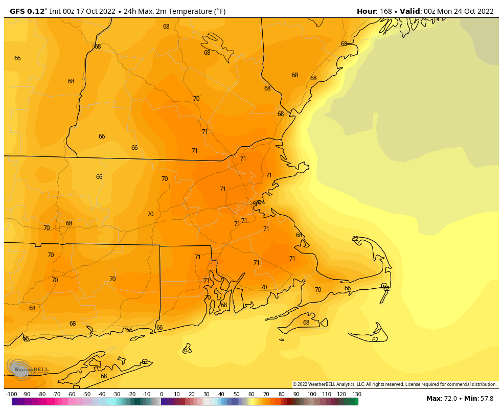
Our unseasonably warm air remains in place for one more day today. A few showers are possible this morning as a cold front crosses the region, then we’ll have a sunny a warm afternoon. The colder air lags a bit behind the front, but it will start to move in late in the day. High pressure then builds inf for Tuesday and Wednesday with sunshine and much cooler temperatures, though they’ll actually be fairly close to normal for early November. As the high slides off to the east, well warm back up for Thursday and Friday. While it won’t be as warm as it was over the weekend, it’ll still be rather mild for the first half of November. After that, the changes really start.

An area of low pressure is slowly organizing east of the Bahamas. It will likely become a tropical depression soon (possibly even before you read this). It will likely become a tropical storm or the next day or so, and could even become a hurricane. While it may seem unusual for a hurricane this late in the year, Hurricane Season doesn’t end until November 30 for a reason. This system will likely head westward, passing close to or over the northern Bahamas before heading for the east coast of central Florida. Eventually, the storm will turn northward as a deepening trough of low pressure moves toward the East Coast. When this turn occurs is still a bit of a question, and while it will have a significant impact for Florida and the Southeast, for us up here, it doesn’t make too much of a difference (more on that in a bit). A turn before reaching Florida would obviously spare the state from the worst of the impact, delaying the turn until it crosses the state and moves into the Gulf increases the threat to western Florida and possibly the Panhandle. The most likely scenario though is a northward turn shortly after landfall, bringing it up Florida and into the Southeast. This brings heavy rain and strong winds to much of the state, while storm surge also an issue for the east coast of Florida.
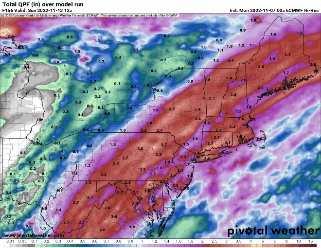
Once it makes that turn, it will turn more toward the northeast, likely moving back offshore off the coast of Georgia, and passing close to or just off the Carolina coastline. After that it will head up the coast, passing south and east of New England on Saturday. It won’t be tropical any more at this point, but it will still be a potent nor’easter. As a result, we’ll have some rain, likely heavy, from Friday night into late Saturday. Gusty winds are also likely near the coast. Some of the models are trying to bring a tremendous amount of rain into eastern New England, and given the system’s tropical roots, this is certainly a possibility. However, we’ve seen time and time again the models forecast some very heavy rain several days in advance, and slowly back off those totals as the system gets closer.
As the system moves away, a strong cold front will move through. Behind it, we’ll clear out on Sunday, but much cooler air will settle into the region with high pressure building in. In fact, a much cooler pattern is shaping up for next week, with temperatures likely below normal for a good chunk of the week.

Monday: Cloudy, breezy, and mild with a shower possibly early, then skies clear out in the afternoon. High 71-78.
Monday night: Clear skies (Perfect for viewing the total lunar eclipse late at night). Low 37-44.
Tuesday: Plenty of sunshine, breezy, much cooler. High 48-55.
Tuesday night: Clear skies. Low 28-35.
Wednesday: More sunshine. High 47-54.
Thursday: Sunshine and a few afternoon clouds, milder. High 59-66.
Friday: Increasing and thickening clouds, showers possible late in the day, steady rain develops at night. High 63-70.
Saturday: Cloudy and breezy with periods of rain, possibly heavy at times, ending at night. High 61-68.
Sunday: A mix of sun and clouds, breezy, and much cooler. High 46-53.