Despite the snow last night and this morning, temperatures will remain above normal for much of the upcoming week.
Low pressure slowly pulls away from the region today, with snow lingering near the coast , but the sun may come out as you head westward. Skies should clear out near the coast as well Monday night as the storm finally moves far enough away. Tuesday starts off nice, but clouds return during the afternoon ahead of another fast-moving but weak storm system. A few showers are possible, but temperatures will also turn milder, helping to melt the snow that fell late Sunday and Monday. We’ll start to clear out again on Wednesday as high pressure builds back in with mild temperatures once again.
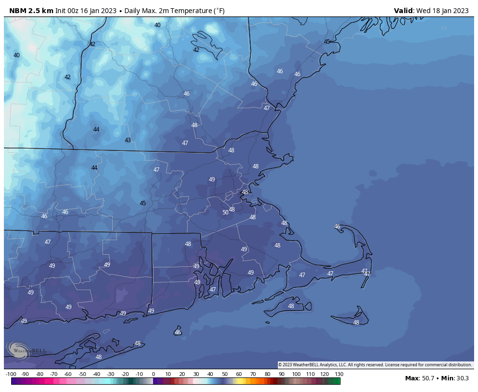
Temperatures could approach 50 degrees on Wednesday. Image provided by WeatherBell.
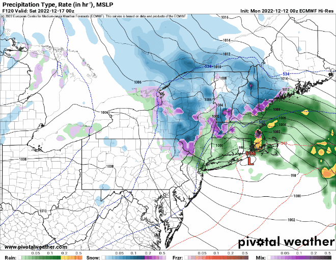
The next system moves toward the region on Thursday, and will impact the region late Thursday into much of Friday. While it will be mostly rain, it may start as snow across southern New Hampshire, where some accumulations are possible. The rain may also change back to snow before ending across the region late Friday. High pressure then builds in for next weekend with drier weather.
The models have different ideas as to where the rain/snow line will start off when precipitation moves in late Thursday. Images provided by Pivotal Weather.
Monday: Plenty of clouds, breezy, some sunny breaks inland, snow showers continue near the coastline, tapering off in the afternoon. Additional accumulation an inch or less. High 32-39.
Monday night: Clearing. Low 24-31.
Tuesday: Morning sun, increasing afternoon clouds. High 39-46.
Tuesday night: Partly to mostly cloudy with a few showers possible. Low 29-36.
Wednesday: Becoming partly to mostly sunny. High 44-51.
Thursday: Becoming cloudy, showers developing late in the day, possibly starting as snow north and west of Boston before changing to rain at night. High 37-44.
Friday: Cloudy with showers ending, possibly as wet snow, especially north and west of Boston. High 36-43.
Saturday: A mix of sun and clouds, chance for a few snow showers. High 35-42.
Quiet weather is expected for much of the upcoming week once again, but that doesn’t mean the entire week will be storm-free.
By mid-week, temperatures will be fairly close to normal for mid-January. Image provided by Weathermodels.com
We start the week off with a very weak system passing by to the south. It spread some clouds in, with a few rain or snow showers possible across southeastern Massachusetts and the Cape and the Islands this morning. We’ll start to clear out in the afternoon as high pressure starts to build in. Some sunshine and seasonably cool temperatures are expected on Tuesday, and even into Wednesday, but during the Wednesday we’ll see some clouds start to move in as low pressure begins heading toward the Midwest. There’s some disagreement among the models on the evolution of this storm, but at this point, it looks likely to be mainly a rainstorm around here, with only a little wet snow possible on the front end of the storm across parts of southern New Hampshire. There’s also some disagreement on the timing of the storm, but right now at least, it looks like it’ll be late Thursday into Friday. There’s some disagreement for Saturday as well. Some of the models have a secondary storm move up the cast, possibly bringing in some more rain or snow, others just have an upper-level disturbance move through with some clouds and a few rain or snow showers. We’re going to lean toward the drier scenario for now, but that can obviously change. High pressure builds in for Sunday.
There’s quite the range of scenarios on Saturday depending on which model you look at. Images provided by Pivotal Weather.
Monday: Morning clouds, maybe a rain or snow shower across Southeastern Massachusetts and the Cape and Islands, clearing in the afternoon. High 36-43.
Monday night: Clear to partly cloudy. Low 23-30.
Tuesday: A mix of sun and clouds. High 34-41.
Tuesday night: Partly cloudy. Low 18-25.
Wednesday: Partly sunny, clouds thicken up late in the day. High 33-40.
Thursday: Cloudy with rain likely late in the day and at night, possibly starting as some wet snow across southern New Hampshire. High 37-44.
Friday: Rain tapers off to showers and ends. High 46-53.
Saturday: More clouds than sun, chance for a rain or snow shower. High 39-46.
This week will start and end with quiet weather, but in between will be interesting.
High pressure provides the region with dry and mild weather today, though not as mild as the past few days. Clouds will start to move in tonight ahead of a low pressure system moving into the nation’s midsection. A warm front will approach on Tuesday, with some light rain and showers likely ahead of it during the afternoon and evening. Much warmer air will move in behind the front for Tuesday night and Wednesday, but the question becomes – how far north does the front get before stalling out. South of the front, temperatures will get well into the 50s or even 60s on Wednesday, but to the north, it will stay in the 40s. At this point, it looks like the front should get north of the Mass Pike and to at least Route 2 and possibly the MA/NH border. Whether it gets farther than that is debatable, or if it even gets that far. Another round of showers is likely Wednesday afternoon and evening as a cold front approaches. The warm front will also begin dropping southward again as a backdoor cold front. Temperatures will drop rapidly once that passes, so timing it correctly will be critical to the forecast. Most of the models have it move through during the evening or at night, but some have it as early as mid-afternoon.
There are significant differences among the models as the how far north the warm air gets on Wednesday. Images provided by Pivotal Weather.
Once the cold front moves through and temperatures start dropping, we could see a change to freezing rain and sleet across the interior late Wednesday night into early Thursday. Another low pressure system passes south of the region later Thursday into early Friday, which may produce some snow across the area, with accumulations possible, especially across the interior. High pressure then builds in for the weekend with drier conditions and seasonably chilly temperatures.
A little snow is possible Thursday night and Friday morning. Image provided by WeatherBell.
Monday: A mix of sun and clouds. High 43-50.
Monday night: Clear skies through the evening, clouds increase overnight. Low 28-35.
Tuesday: Cloudy with light rain and showers developing. High 36-43 north of the Mass Pike, 44-51 south of the Pike.
Tuesday night: Cloudy with a few showers or some drizzle. Temperatures hold steady or rise overnight.
Wednesday: Cloudy, showers redevelop in the afternoon, possibly changing to freezing rain or snow overnight, mainly across southern New Hampshire. High 51-58, possibly much cooler across southern New Hampshire.
Thursday: Cloudy and breezy with some snow showers possible during the day, steadier light snow possible at night. High 37-44.
Friday: Cloudy with a chance for some light snow, mainly in the morning. High 34-41.
The final week of 2022 will feature a warmup across the region.
We start the week off with high pressure in control, keeping us chilly today. We’ll have sunshine in the morning, but clouds start to stream in during the afternoon as a weak disturbance moves toward the region. This may produce a few flurries tonight, but for the most part, we’ll remain dry. High pressure then builds in for Tuesday with clearing skies and temperatures remaining near or a little below normal for late December. The warmup begins on Wednesday, and continues into the weekend, with temperatures getting above normal, perhaps well above normal for New Years Eve and New Years Day, with highs well into the 50s or even near 60. A weak backdoor cold front may try to bring in some cooler weather on Friday, especially from the North Shore to the New Hampshire Seacoast, but this is looking less and less likely as time goes on. The dry weather will continue into Saturday morning, but unfortunately, low pressure will approach later or New Years Eve into New Years Day with some rain, especially on Sunday.
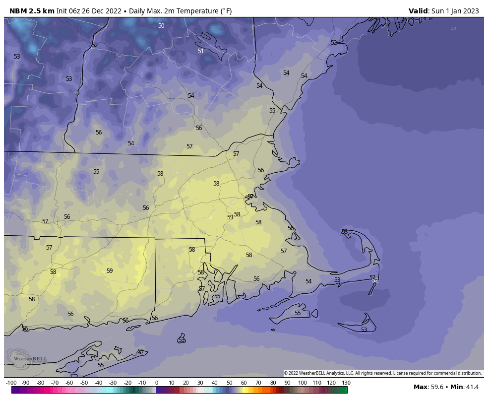
It looks like 2023 is going to start on a very mild note. Image provided by WeatherBell.
Monday: Morning sunshine begins to fade behind increasing and thickening afternoon clouds. High 26-33.
Monday night: Cloudy with a few flurries possible, some clearing develops late at night. Low 16-23.
Tuesday: Becoming mostly sunny. High 28-35.
Tuesday night: Clear to partly cloudy. Low 15-22.
Wednesday: Partly sunny, milder. High 34-41.
Thursday: A mix of sun and clouds. High 41-48.
Friday: Partly sunny and mild. High 47-54.
New Year’s Eve: Mostly cloudy, showers possible during the afternoon, becoming more likely at night. High 49-56.
Christmas Week will start and end dry, but the latter half of the week looks rather stormy.
Whatever you celebrate, we hope you enjoy it! Image provided by Adobe.
We start the week off with high pressure trying to build in while low pressure continues to meander around near Atlantic Canada. The result is dry weather through Wednesday as the high will be the dominant feature, but the gradient between the high and the offshore low will result in breezy conditions today and Tuesday. Temperatures will be fairly close to where they should be in the latter half of December.
Wind chills will be in the teens when many of you head out the door Tuesday morning. Image provided by Weathermodels.com
The end of the week is where things get rather complicated. Most of the models are trying to spin up a very strong storm and send it towards the Great Lakes. As a result, you’ve no doubt seen plenty of forecasts out there for a wind-swept mild rain on Friday. The people making these forecasts are taking the lazy way out, believing everything the models are saying, and not looking too deeply at the situation. That’s not how we do things here. Yes, the precipitation will be mostly likely be in the form of rain with this storm, and temperatures will probably be milder than normal. But a wind-swept mild rain? Far from a lock. In fact, we’re not sure that will materialize for a good chunk of the region. Allow us to explain:
First, the upper-level pieces of energy that will create the storm are still over water, in areas where there is little data, so the models are just guessing at this point. That will change in the next 24 hours or so as those upper-level disturbances move into Alaska and California respectively, so we’ll start to get a better idea of what will happen. Second, this storm may be in two parts, one late Thursday into early Friday and the second late Friday and Friday night, with a bit of a lull possible during the day on Friday. The first piece of energy, with the southern jet stream, likely stays weak and scoots along ahead of the main system. This may help to kick off a weak area of low pressure near the East Coast on Thursday, which could bring in some rain, but it may start a snow or a wintry mix across the interior before changing over to rain. As the northern stream energy moves into the Plains States, it will carve out a rather deep trough of low pressure at the upper-levels, which in turn will generate a rather potent storm system in the nation’s mid-section, which likely heads toward the Great Lakes. This is where our uncertainty starts to increase. Right now, the models keep those two streams separate. What happens if the southern stream storm is a little slower than the models forecast, and they do merge (or “phase”, as we usually call it)? Well, that could result in a stronger storm in the Midwest, possibly even a little farther west than the models show now. It also would lessen the likelihood of that rain and/or mix moving in here later Thursday. What about if that trough in the Plains States isn’t as sharp as the models predict? Well, then the storm ends up farther east, which has different implications here. When storms end up as far west the models currently show, it’s easy to look at the maps and say “it’ll be windy and warm east of the storm,” and assume that is the case all the way to the coast, but that’s the lazy way out.
The members of the GFS Ensemble all show a potent low near the Great Lakes on Saturday and a secondary low near or off the Mid-Atlantic coast. Image provided by WeatherBell.
In reality, when storms head up across the central and western Great Lakes, what usually happens is a weak wave of low pressure forms ahead of the main storm somewhere near the Mid-Atlantic states. What that does, is it pinches off the warm air at the surface. Yes, we’ll still have strong southerly winds pumping in lots of moisture and warmer air aloft, but at the surface, you end up with east or northeast winds, keeping the cooler air locked in under what we call an inversion. Normally, temperatures decrease with height as you head up into the atmosphere. When it’s warmer as you go higher, the temperature profile is “inverted”. This also prevents those strong winds aloft from mixing down to the surface. So, you may get windy and mild conditions near the South Coast, but places like the Merrimack Valley and southern New Hampshire could stay stuck in the upper 30s and lower 40s with little wind, but some rain, drizzle, and fog. We’ve seen this happen countless times, and wouldn’t be shocked if that’s what ends up happening around here on Friday. Eventually, as the storm moves into southeastern Canada, it will send a strong cold front in. Some rain, possibly heavy is likely ahead of that front, it the gusty winds associated with the front will eventually mix out that inversion, so temperatures could briefly spike well into the 50s or even lower 60s as the milder air moves in for a brief period ahead of, or even behind the front.
Friday’s high temperatures likely occur at night, then temperatures turn sharply colder on Saturday. Loop provided by Pivotal Weather.
For Christmas Eve and Christmas Day we’ll have high pressure trying to build in with clearing, breezy, and colder conditions.
Monday: Sunshine and some afternoon clouds, breezy. High 34-41.
Monday night: Clear skies. Low 22-29.
Tuesday: Plenty of sunshine. High 33-40.
Tuesday night: Clear to partly cloudy. Low 18-25.
Wednesday: A mix of sun and clouds. High 33-40.
Thursday: Mostly cloudy, rain developing late in the day, possibly starting as some snow or freezing rain across the interior. Rain may be heavy at night. High 39-46.
Friday: Cloudy, breezy along the coast, rain likely, possibly heavy at times, especially early and again late in the day. Rain may mix with or change to wet snow before ending at night. High 51-58 during the evening, but temperatures may stay in the upper 30s and 40s for much of the afternoon across the interior.
Christmas Eve: Becoming partly sunny and breezy with a few flurries possible, especially early. High 30-37 early, temperatures drop a little during the afternoon.
Christmas Day: Partly to mostly sunny, breezy, and chilly. High 25-32.
Colder weather has arrived, and more is on the way, but so is some rain.
The week starts off with low pressure pulling away from the region, with any lingering snow showers ending this morning, then skies start to clear out as high pressure builds in. Clear skies, lighter winds, and some fresh snowcover will result in radiational cooling tonight, with many places dropping into the teens. High pressure remains in control on Tuesday with sunshine and cool temperatures. An upper-level disturbance moves through on Wednesday, and it may be accompanied by some snow showers, especially along the coast. Even colder air settles in behind it for Wednesday night.
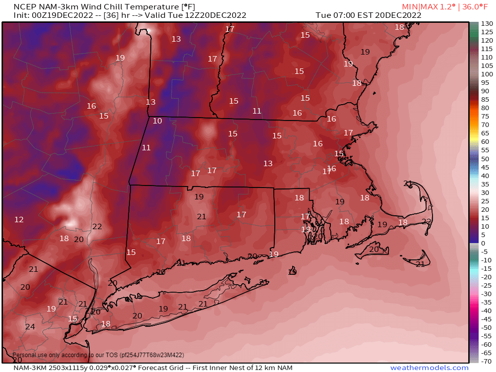
Wind chills will be in the teens when you leave the house Tuesday morning. Image provided by WeatherBell.
Clouds start to stream back in on Thursday as low pressure begins to head toward the region from the Southwest. For most of the region, this looks like a rainstorm for Thursday night and Friday, but a period of snow or wintry mix to start across parts of central Massachusetts and southwestern New Hampshire. However, this is still 4-5 days away, and a lot can change between now and then. Even small changes to the track that the low takes can have a big impact on the forecast. A track farther south and/or east could result in in wintry weather for a larger portion of the region and potentially for a longer period of time. We’ll be keeping a close eye on this as the week goes on. Behind the storm, cooler and drier weather returns next weekend.
Friday looks rather unsettled, but there are still plenty of details to work out. Images provided by Pivotal Weather.
Monday: Any lingering snow showers end early, then becoming partly to mostly sunny and breezy. High 33-40.
Monday night: Some clouds across the Outer Cape, otherwise clear and chilly. Low 16-23.
There’s a considerable amount of uncertainty in this week’s forecast, specifically the end of the week and next weekend, but even the first part of the week isn’t so clear-cut.
The week starts off with high pressure in control, resulting in a rather nice day by early December standards. Temperatures will start off cool, but with sunshine we’ll warm up nicely into the 40s in most spots. Clouds will start to stream in and thicken up during the afternoon and evening as a frontal system begins to approach from the west. Rain will develop during the day on Tuesday, but the temperatures are a bit of a question mark. Winds will shift into the southeast, allowing relatively milder air to move into parts of the region, but across the interior, the cooler air may hang on for quite a while. This is actually fairly typical for this time of year, and where the forecast models often struggle. They usually bring the warmer air in too quickly, but it often takes a lot longer than expected away from the coastline. This is more prevalent when there is snowcover, but it is not always necessary. The warmer air should eventually spread across the region Tuesday night and Wednesday, with highs on Wednesday getting into the 50s in many locations. The rain will continue Tuesday night into Wednesday as well, and while it may not be raining the entire time, some locally heavy rain is possible in spots. Rain eventually winds down Wednesday night as a cold front finally crosses the region, but it may not completely move offshore until Thursday morning. Skies may be slow to clear on Wednesday, and temperatures will turn cooler, but will probably still be above normal.
Normal high temperatures for early December are in the lower to middle 40s. Image provided by Weathermodels.com.
Friday and the weekend is where the forecast confidence goes right down the tubes. The upper-level pattern will begin to change, with a blocking pattern setting up. A strong area of high pressure will settle in over Greenland, with a broad upper-level low pressure system setting up over eastern Canada. Exactly where these features setup will have a drastic impact on our weather. In some cases, this setup can result in a rather stormy pattern across our area, but if the features aren’t in the right spot, then storms could mostly shift south of us, and we stay cold and dry. At various times over the past several days, the models have indicated that either scenario is possible. A low pressure system will move out of the Tennessee Valley and head toward the Mid-Atlantic states on Friday, moving offshore and then likely meandering around off the East Coast through the weekend. Is the storm far enough north initially to bring us some rain (or snow)? When the storm is hanging around during the weekend, will it impact our area at all? If so, what will those impacts be? These are questions that just cannot be answered at this time, as there is just too much uncertainty. We are fairly sure that temperatures will turn cooler as the pattern changes, but will they still be above normal, closer to normal, or even below normal next weekend? There’s plenty of cold air that’s been building up in Canada, but will it get in here next weekend, or will it move in during the following week? Again, at this point, we just don’t know. We should have more clarity on Thursday when we publish our Weekend Outlook.
The models all have a storm off the East Coast next Saturday morning, but the details vary widely. Images provided by Pivotal Weather.
Monday: Mostly sunny through midday, clouds start to move in during the afternoon. High 43-50.
Monday night: Increasing and thickening clouds. Low 31-38.
Tuesday: Cloudy with showers developing in the afternoon. High 49-56.
Tuesday night: Periods of rain and showers. Low 42-49.
Wednesday: Occasional rain and showers, ending at night. High 49-56.
Thursday: Becoming partly sunny. High 47-54.
Friday: Partly to mostly cloudy and breezy with a chance for showers. High 40-47.
Saturday: Mostly cloudy and breezy with a chance for snow or rain showers. High 37-44.
Sunday: Mostly cloudy with a chance for snow or rain showers. High 39-46.
Meteorological Winter begins on Thursday, but Mother Nature doesn’t want to bring us any winter weather anytime soon.
A cold front will cross the region today, and although it will have little moisture with it, it will bring breezy and cooler weather in for later today and into Tuesday. We’ll warm back up on Wednesday ahead of another storm system. That system passes to our north and west, with some rain likely late Wednesday and Wednesday night. As colder air settle sin behind the storm, some wet snow may mix in before the precipitation ends across the hills of central Massachusetts and southwestern New Hampshire. High pressure builds in behind that system with chilly weather for Thursday and Friday. We may warm up again on Saturday ahead of yet another cold front that could bring in some showers, with cooler weather returning on Sunday.
Wind chills will be in the 20s for the Patriots showdown with the Bills in Foxborough Thursday evening. Image provided by WeatherBell.
Monday: Some clouds around in the morning, becoming mostly sunny and breezy in the afternoon. High 48-55.
Monday night: Clear skies. Low 24-31.
Tuesday: A mix of sun and clouds. High 39-46.
Tuesday night: Partly to mostly cloudy. Low 28-35.
Wednesday: Mostly cloudy and windy with rain developing in the afternoon, ending at night, possibly mixed with some wet snow across the Worcester Hills and the Monadnocks. High 54-61.
Thursday: Sunshine and a few clouds, windy, much cooler. High 38-45.
Friday: Partly to mostly sunny. High 39-46.
Saturday: Partly to mostly cloudy, breezy, chance for some showers. High 50-57.
Half of this week will be decent, and the other half may or may not be unsettled.
We’ve got high pressure in control for the next few days with generally dry weather and moderating temperatures. A weak frontal system moves through late Wednesday with little fanfare, but it will bring some cooler air back in for Thanksgiving Day. We’ll also see clouds stream in on Thanksgiving as low pressure begins to make its way up the East Coast. This is where things become very uncertain.
Temperatures could reach 50 in parts of the area on Wednesday. Image provided by WeatherBell.
The models have been consistently inconsistent with this storm. They never seem to agree with each other, and they change their tune on nearly every run. Sometimes it’ll look likely a coastal storm with strong winds and heavy rain, and possibly a wintry mix across the interior, some runs the storm goes up to the west of us, so we get rain and milder temperatures, some runs it’s a coastal storm well offshore and a weaker system moving across northern New England with just a few showers. Some runs have the storm Friday, some Saturday, and now, some even have it on Sunday. At this point, it’s just too early to nail down any details. What you’ll see below is our best guess at this point, but really, we could just write in “Partly to mostly ____ with a chance of _____”, and that would probably cover it too. We should have more clarity when we post our Weekend Outlook, which will be done on Wednesday this week instead of Thursday due to Thanksgiving.
The models have differing ideas on a potential late-week storm. Images provided by Pivotal Weather.
Monday: Sunshine and a few clouds, breezy. High 36-43.
Monday night: Clear skies. Low 26-33.
Tuesday: Sunshine and some afternoon clouds. High 40-47.
Tuesday night: Clear skies. Low 26-33.
Wednesday: Plenty of sunshine. High 44-51.
Thursday: Morning sun, then increasing and thickening clouds. High 41-48.
Friday: Mostly cloudy with a chance of rain. High 47-54.
Saturday: Partly to mostly cloudy and breezy with a chance of rain. High 47-54.
Uh oh. It’s that time. You might want to sit down. Yup. We’ve got some bad news for you. That word is in the forecast. You know which one we’re talking about. The one that you really don’t like. At all. It’s 4 letters, begins with “s” and ends with “w” and it rhymes with “no”. Yeah, that word. You knew it was coming eventually, but you still didn’t want to hear (or read) it. Well, it’s too late. You’ve been warned.
We start the week off with high pressure in control for Monday. The result is plenty of sunshine, but rather chilly temperatures, a stark contrast to what we had over the weekend. But, it is November, and the nice weather can’t last forever, because this is New England, not Miami or San Diego or St. Croix. Tuesday looks dry and chilly too, but we’ll have clouds streaming in ahead of a low pressure system moving toward the region.
Normal high temperatures for mid-November are within a degree or two of 50. Iage provided by Weathermodels.com
Tuesday night, some moisture will start streaming in ahead of that storm, and with temperatures likely near or below freezing, we may see some (WARNING: BAD WORD INCOMING) “snow” developing across the area. For areas from Boston southward, it may be just a few flurries or sprinkles Tuesday evening. The more substantial moisture moves in overnight, with most rain in the I-95 corridor and points south and east. North and west of there, especially outside of I-495, some wet snow may develop, but even here, it should change to rain by daybreak. The pavement remains far too warm for any accumulations (except for bridges and overpasses), but grassy surfaces, and car windshields could see some slushy accumulation, perhaps up to an inch as you head into southern New Hampshire. Across the Worcester Hills and up into the Monadnocks, there could even be a little more than that. Everything changes over to rain during the morning, and rain continues into the afternoon before winding down. There could be some gusty winds along the coast as well, but all in all, this is not a big deal. Across parts of Cape Cod and potentially southeastern Massachusetts, temperatures could briefly spike into the 50s or even 60s if the low tracks across the area, but for the rest of, Wednesday will feature temperatures in the 40s or even 30s.
If you’re out and about before daybreak Wednesday, precipitation may not be all rain. Images provided by Pivotal Weather.
An upper-level trough of low pressure crosses the Northeast of Thursday with some clouds and possibly a few sprinkles or flurries. High pressure then builds in for the end of the week and the weekend with generally dry and chilly conditions.
Temperatures on Saturday could be 10-15 degrees below normal. Image provided by WeatherBell.
Monday: Plenty of sunshine, breezy at times. High 40-47.
Monday night: Mostly clear skies. Low 21-28.
Tuesday: Some morning sun, then clouds stream in. High 39-46.
Tuesday night: Cloudy with light rain developing at night, starting as light snow or a wintry mix north and west of Boston, gradually changing to all rain by daybreak. Up to an inch of slushy accumulation is possible on grassy surfaces north and west of I-495. Low 27-34, temperatures slowly rise after midnight.
Wednesday: Any lingering wintry mix changing to all rain, ending during the afternoon. High 40-47 north and west of Boston, 48-55 south, potentially warmer across Cape Cod.
Thursday: Partly sunny, breezy, chance for a rain or snow shower. High 40-47.
Friday: Partly to mostly sunny, breezy. High 39-46.