Much of the forecast for this week is fairly straightforward, but it gets very complicated next weekend.
An upper-level trough of low pressure will move across the Northeast today into Tuesday. This means we’ll have some clouds popping up with a few showers developing during the afternoon, mainly on Monday, but a couple are possible on Tuesday as well. Wednesday through Friday will feature high pressure, which means we’ll remain dry and on the cool side. Next weekend has a high amount of uncertainty, and it has to do with Tropical Storm Ian.

As of 12am Monday, Tropical Storm Ian was centered about 115 miles south-southwest of Grand Cayman, moving toward the northwest at 13 mph. Maximum sustained winds were near 70 mph. The forecast calls for Ian to pass close to the Cayman Islands on Monday as a hurricane, then near or across western Cuba Monday night and Tuesday before moving into the southeastern Gulf of Mexico. Ian could rapidly intensify into a major hurricane over the next few days. After that, its future gets a little murkier. A trough of low pressure across the eastern US should steer Ian northward and at some point northeastward, but when it makes that turn is not clear. This impacts where and when landfall will occur. At this point, landfall is possible anywhere from Fort Myers, Florida all the way to New Orleans. Complicating matters even more is the fact that as it gets farther northward, drier air and wind shear will act to weaken the storm. So, a sooner landfall (say in the Ft Myers to Tampa area) could result in a stronger storm making landfall, but if it heads toward the Florida Panhandle or central Gulf Coast, it could be considerably weaker at landfall. An earlier turn toward the northeast could also result in Ian moving back into the Atlantic, and thus could be a threat to the Carolinas.
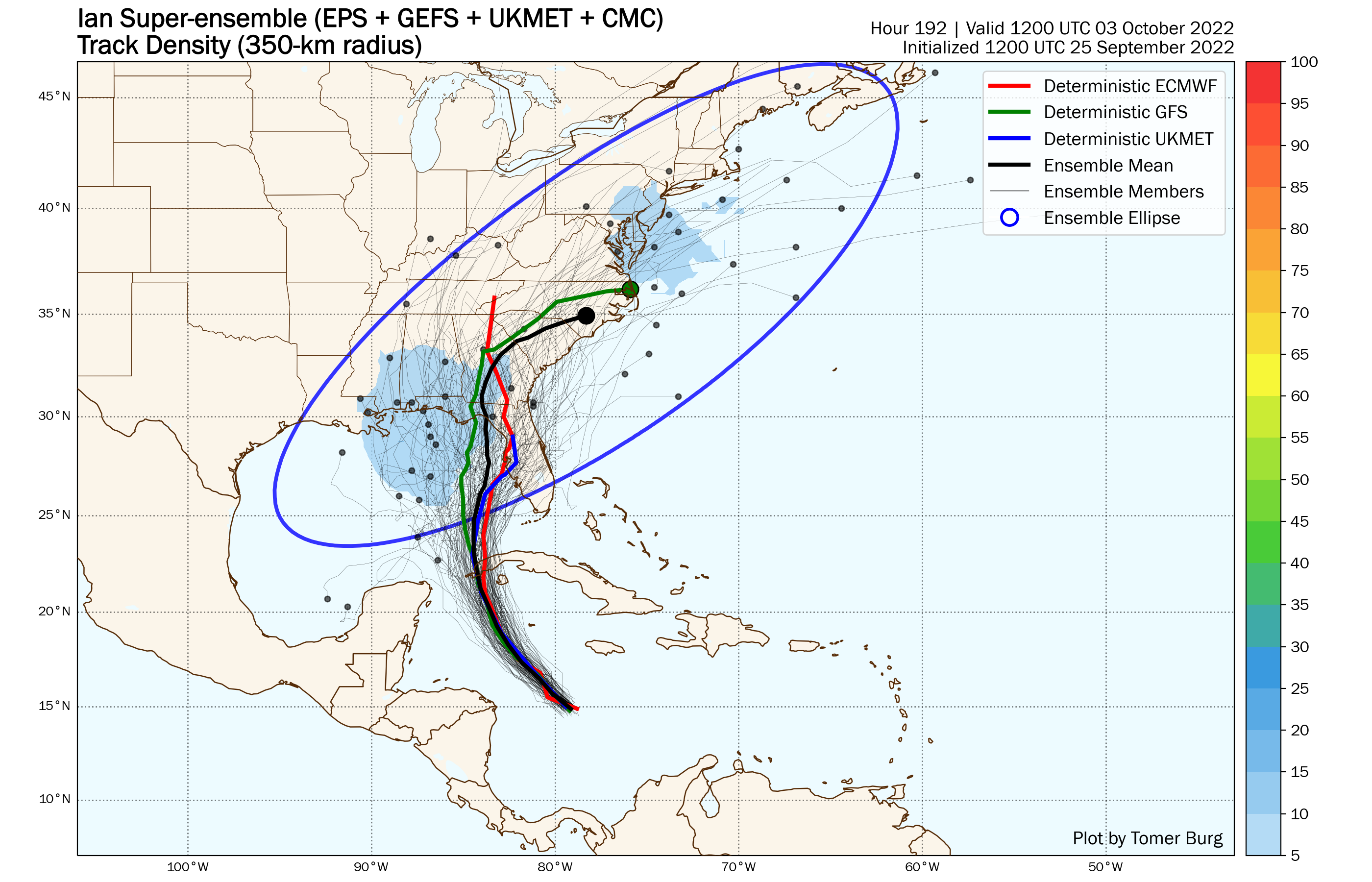
So, how does that impact our forecast next weekend? Well, an earlier turn would likely keep the storm off to our south, with high pressure holding on over the Northeast, keeping us drier. A landfall farther north likely results in the storm rapidly weakening over land, but increases the possibility that the remains move up the Appalachians and bring some rain, possibly heavy, in here or across northern New England next weekend. At this point, it’s just too early to figure out which scenario may occur, so we’re going to be very vague in the forecast for now.
Monday: A mix of sun and clouds with a few showers possible in the afternoon, mainly north and west of Boston. High 68-75.
Monday night: Partly cloudy, chance for a few showers during the evening. Low 51-58.
Tuesday: Partly to mostly sunny, just a slight chance for an afternoon shower. High 67-74.
Tuesday night: Clear skies. Low 47-54.
Wednesday: A mix of sun and clouds. High 64-71.
Thursday: Partly to mostly sunny. High 60-67.
Friday: Partly sunny. High 59-66.
Saturday: Intervals of clouds and sun with a chance for showers. High 63-70.
Sunday: More clouds than sun with a chance for showers. High 63-70.
