Fall is the season of change, and changes are coming this weekend in terms of the weather.
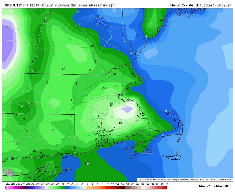
High pressure remains in control into Friday with another warm day expected under partly sunny skies. However, a strong cold front is marching eastward, and it will arrive on Saturday. Ahead of it, a warm front will move through Friday night, perhaps accompanied by a few showers. Saturday will be breezy and warm, but we’ll have plenty of clouds, with showers developing by late afternoon. Showers and some thunderstorms are likely through the evening, but should end before daybreak Sunday as the cold front finally crosses the region. Behind the front, breezy and much cooler conditions are likely for Sunday and Monday. While it will feel almost chilly at times, these temperatures will be right around normal for mid-October. Both Sunday and Monday will feature some sunshine, but with an upper-level disturbance moving through, we’ll have clouds developing, and just a slight chance for a shower each afternoon.
Temperatures at midday Sunday will be 10-15 degrees cooler than at midday Saturday. Image provided by WeatherBell.
Thursday night: Partly to mostly cloudy. Low 53-60.
Friday: Intervals of clouds and sun. High 68-75, possibly a little cooler along the coast.
Friday night: Plenty of clouds, chance for a few showers. Low 57-64.
Saturday: A few sunny breaks, mainly early, but generally cloudy and breezy with showers possible late in the day. High 69-76.
Saturday night: Scattered showers, possibly some thunder as well. Low 49-56.
Sunday: Any lingering showers end early, otherwise a mix of sun and clouds, breezy, slight chance for an afternoon shower. High 60-67.
Sunday night: Clear to partly cloudy. Low 42-49.
Monday: Partly sunny, chance for an afternoon shower. High 54-61.
Columbus Day Weekend has arrived, but it still won’t feel quite like fall just yet for the entire weekend.
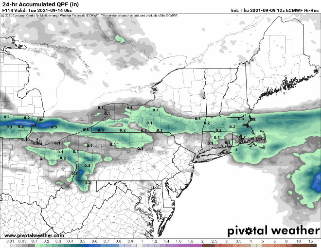
High pressure remains in control through the 1st part of Friday with dry and mild conditions, but a backdoor cold front will drop down the coast, bringing cooler weather in for Friday night and Saturday. There may even be some drizzle or a few showers around at times too. High pressure builds back in for Sunday, but we’ll have to keep an eye on low pressure south of New England. There is still some question as to whether the rainfall from this system makes it into our area Sunday night and Monday. We’ll include the chance for showers in the forecast for now, but the most likely spot for any rain will be along the South Coast.
Most of the models aren’t terribly enthusiastic about the rain chances for Sunday night and Monday. Images provided by Pivotal Weather.
Thursday night: Clear skies. Low 48-55.
Friday: Sunshine gives way to increasing afternoon clouds. High 66-73.
Friday night: Mostly cloudy with some patchy drizzle or a few showers. Low 47-54.
Saturday: Clouds and a few sunny breaks, some spotty drizzle or a shower are still possible. High 59-66.
Saturday night: Mostly cloudy. Low 47-54.
Sunday: Plenty of clouds. High 61-68.
Sunday night: Partly to mostly cloudy with a chance of showers, mainly near the South Coast. Low 50-57.
Monday: More clouds than sun, showers are possible again, mainly near the South Coast. High 66-73.
Most of the upcoming weekend should be pretty good weatherwise, but probably not all of it.
An upper-level low pressure area will pull away tonight, but a few showers are still possible through the first part of the night, mainly near the coastline. High pressure builds in for Friday into Saturday with drier conditions. While Friday should feature a decent amount of sunshine, Saturday will likely have more clouds as a weak system passes by to the north. Could it produce a few showers? Maybe, but mainly in southern New Hampshire.
Friday morning will be on the chilly side. Image provided by WeatherBell.
Sunday is when things get really tricky. A low pressure area will be slowly moving in from the west, sending a warm front toward the region. The question is, how far north does the warm front get before stalling out? This will have a large impact on temperatures. Our best estimate at this point is that it will at least get up to the Mass Pike, but beyond that, we’re not sure. South of the warm front, it will be warm and humid, with temperatures likely getting into the 70s. North of the front it may stay in the upper 50s and lower 60s. The next question is – when does the rain move in? Right now, it looks like we may have some showers late Sunday afternoon and evening ahead of the warm front, but that isn’t set in stone at this point. Late Sunday night into Monday do look wetter, but again, this is far from a lock.
Sunday’s temperatures will be determined by how far north the warm front gets. Images provided by Pivotal Weather.
Thursday night: Mostly cloudy with a few showers possible this evening, then skies clear out overnight. Low 40-47.
Friday: Sunshine and some afternoon clouds. High 60-67.
Friday night: Partly to mostly cloudy. Low 43-50.
Saturday: More clouds than sun, slight chance for a sprinkle across southern New Hampshire. High 65-72.
Saturday night: Partly to mostly cloudy, slight chance for a shower, mainly across southern New Hampshire. Low 50-57.
Sunday: Mostly cloudy, chance for a few late-day showers. High 59-66 north of the Mass Pike, 67-74 south of the Pike.
Sunday night: Mostly cloudy with showers developing. Low 53-60.
Monday: Mostly cloudy with scattered showers. High 62-69.
Some rain is on the way, but much of the weekend looks decent weatherwise.
A slow-moving cold front will make its way across the region tonight and Friday, bringing plenty of clouds in, with some rain likely, mainly on Friday. A few rumbles of thunder are also possible. We’re not expecting a widespread heavy rain like we had at times for most of the summer, but don’t expect to see much, if any, sunshine on Friday. The front pushes offshore Friday night, but showers may linger into Saturday morning across eastern Massachusetts. While there may be some sunshine developing, especially well west of Boston, during Saturday afternoon, clouds will linger in the east. Another wave of low pressure will ride up that front offshore, but will likely pass close enough to bring some rain back in for Saturday night and Sunday morning. This is a relatively new development in the models, but it shows up on several models, so we’re inclined to go with it. We should start to clear out again on Sunday, but an upper-level feature will be moving across the region, and it may kick off another shower or two during the afternoon. High pressure builds in for Sunday night and Monday with drier conditions.
Most of the heavy rain will be confined to western New England. Image provided by Weathermodels.com
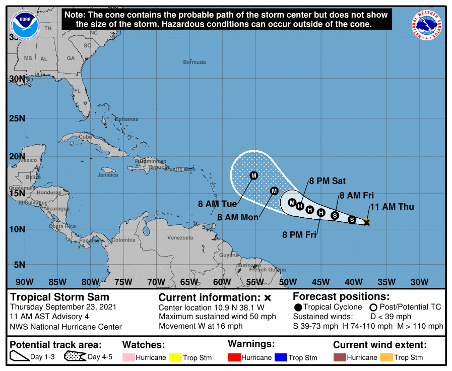
In the tropics, Tropical Storm Sam has developed over 1700 miles east of the Lesser Antilles. It is sat least 5 days away from potentially threatening any land areas, but Sam will definitely be a storm to watch. Most of the models develop Sam into a powerful hurricane over the weekend and early next week. Sam should continue on a west-northwest track across the Atlantic through the weekend. Beyond that? It’s still way too early to speculate on where Sam may go.
Forecast track for Tropical Storm Sam. Image provided by the National Hurricane Center.
Thursday night: Partly to mostly cloudy with a few showers possible. Low 64-71.
Friday: Cloudy with scattered showers, possibly a thunderstorm. High 71-78.
Friday night: Mostly cloudy, showers ending from west to east. Low 55-62, a little milder across Southeastern Massachusetts and Cape Cod.
Saturday: Intervals of clouds and sun, chance for a few showers, mainly in eastern Massachusetts. High 68-75.
Saturday night: Mostly cloudy with more showers possible. Low 53-60.
Sunday: Any lingering showers end early, then becoming partly sunny with a chance for a late-day shower. High 68-75.
Improving weather is coming, but it will take a little while to get here this weekend.
A frontal system will wash out along the South Coast tonight and Friday while high pressure tries to build in. The result will be mainly dry conditions, but still plenty of cloud cover, especially along the South Coast. Temperatures will remain on the cool side compared to the last few days thanks to northeast to east winds, but we should still see most places get into the 70s.
Skies are clearing out not far to our north and west, Meanwhile, low pressure is trying t organize off the Carolina coast. Loop provided by NOAA.
Meanwhile, an area of low pressure off the Carolina coast is trying to organize this afternoon and it could become a tropical depression or even a weak tropical storm over the next day or so. It will move northward and then northeastward, passing well south and east of us Friday night and Saturday. However, it will bring some gusty northeast winds to coastal areas, and churn up the seas again, resulting in some rough surf and rip currents at the beaches.
Forecast tracks for the disturbance off the Carolina coast from the various members of the GFS Ensemble. Image provided by Weathernerds.org
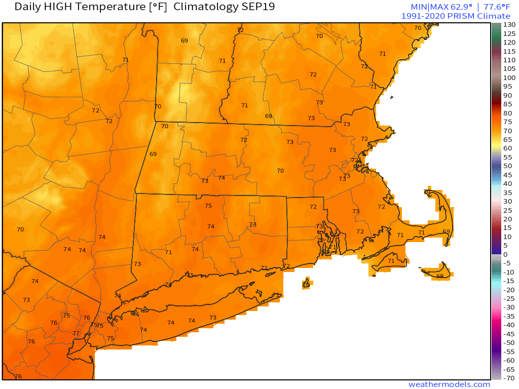
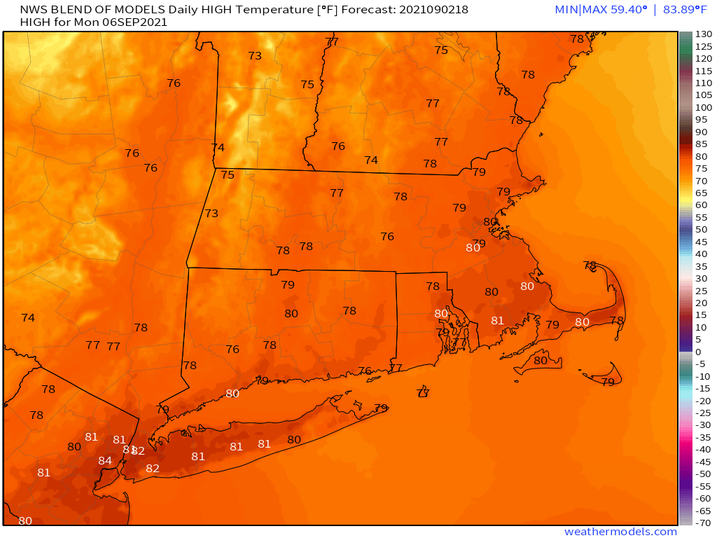
A weak cold front will also be moving in on Saturday, with a few showers possibly accompanying it. For later Saturday into Sunday and Monday, we’ll have high pressure building in, which means sunshine and mild temperatures, which is about as good as it gets for the final weekend of astronomical summer. Fall begins with the autumnal equinox at 3:20pm next Wednesday.
Average high temperatures in mid-September are in the lower to middle 70s around here. Image provided by Weathermodels.com
Thursday night: Mostly cloudy, chance for a few showers across the South Coast and Cape Cod. Low 58-65.
Friday: Partly to mostly cloudy. High 70-77.
Friday night: Partly to mostly cloudy. Low 60-67.
Saturday: A mix of sun and clouds, slight chance for a shower, mainly well north and west of Boston. High 72-79.
Saturday night: Mostly clear. Low 57-64.
Sunday: Plenty of sunshine. High 69-76.
Sunday night: Clear skies. Low 50-57.
Monday: Unlimited sunshine (daylight hours only). High 71-78.
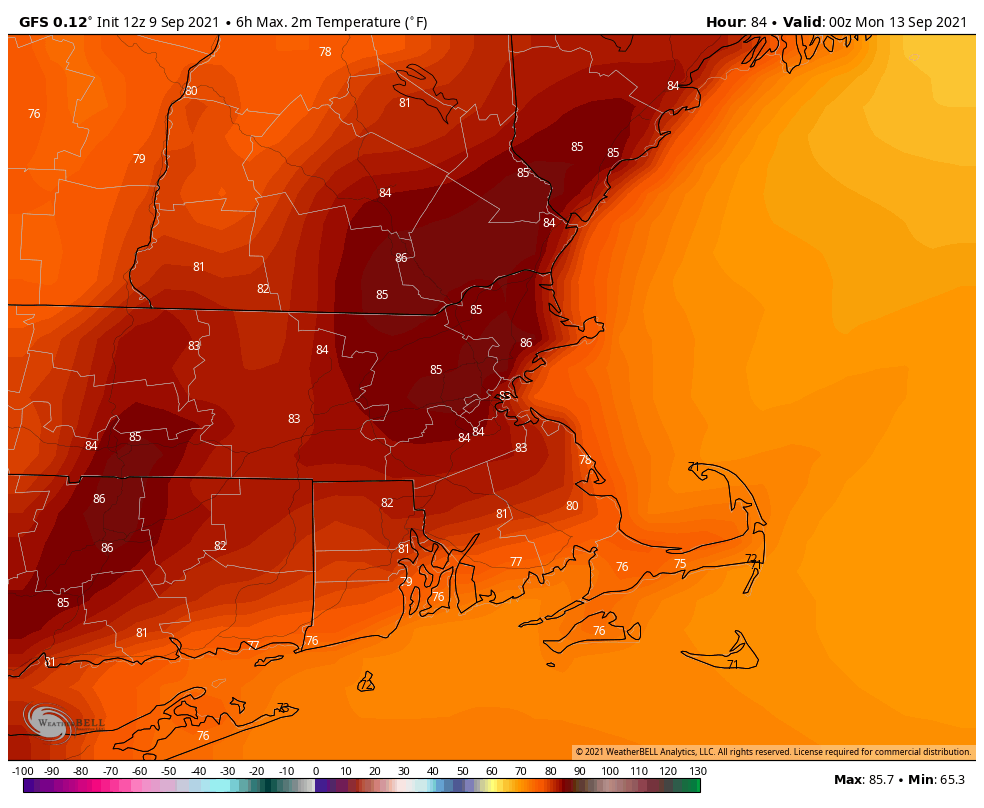
We have got an absolutely fantastic stretch of weather on tap for the upcoming weekend.
Sunday is looking like a rather warm day for mid-September. Image provided by WeatherBell.
Before we get to the nice weather, we’ve got some rain tonight as a cold front crosses the region. The rain will end from west to east tonight, and skies will start to clear out by daybreak. On Friday, we’ll have an upper-level disturbance moving through. So we’ll start off with sunshine, but clouds will develop, and a few pop-up showers are possible. We’ll clear out again Friday night as high pressure builds in. With clear skies and light winds, we’ll have radiational cooling, which could result in a rather cool night in some spots. Saturday will feature sunshine and mild temperatures. As the high slides offshore, we’ll warm up on Sunday, just in time for the Patriots season opener in Foxborough. Another cold front will move through on Monday with some clouds and a few showers. There is the chance that Monday may not be as nice as we’re currently forecasting it to be. Some of the newer model runs are going for a cloudy day with more rainfall and cooler temperatures. This is a shift from what they had been previously been showing, so we’re not going to jump on that bandwagon yet, but we’re keeping an eye on it.
Will it rain Monday? Some models say yes, some don’t. We’ll see what happens. Images provided by Pivotal Weather.
Thursday night: Showers ending followed by some clearing late at night. Low 57-64.
Friday: Sunshine and some afternoon clouds, maybe a shower or two. High 68-75. Offshore: Northwest wind 10-15 knots, gusts to 20 knots, seas 3-6 feet, up to 6-9 feet in the waters south and east of Cape Cod and the islands.
Friday night: Clear and cool. Low 49-56.
Saturday: Sun, sun, and more sun. High 69-76. Offshore: West winds 5-15 knots, seas 3-5 feet, up to 5-8 feet in the waters east of the Cape and Islands.
Saturday night: Clear skies. Low 57-64.
Sunday: Sunshine and a few clouds. High 76-83. Offshore: West to southwest winds 10-20 knots, seas 3-5 feet.
(Kickoff Forecast for Foxborough: Sunny, temperature near 80, southwest winds 10-15 mph.)
Sunday night: Partly to mostly cloudy. Low 60-67.
Monday: Intervals of clouds and sun, chance for a few showers. High 74-81. Offshore: West to southwest winds 10-20 knots, seas 3-6 feet.
After yet another deluge, the unofficial end of summer will feature mostly dry weather.
Over the past 60 days, most of the region has received 2-3 times the normal amount of rainfall. Image provided by WeatherBell.
High pressure builds in tonight with dry and cool conditions. Friday will remain mostly dry with high pressure in control, but an upper-level low will slowly pull away and a disturbance riding around it will produce some clouds, and possibly a sprinkle or shower Friday afternoon. The high slides offshore on Saturday, keeping us dry, but temperatures will start to warm up once again. A weak frontal system moves through on Sunday with plenty of clouds, and a few showers Sunday afternoon and night. The system pulls away on Labor Day and high pressure builds back in, with dry and seasonably warm conditions returning.
Labor Day looks it will be seasonably warm once the skies start to clear out. Image provided by Weathermodels.com
Thursday night: Clear and cool. Low 49-56.
Friday: Sunshine and some afternoon clouds, chance for a sprinkle or shower during the afternoon. High 66-73. Offshore: Northwest winds 5-15 knots, seas 2-4 feet.
Friday night: Becoming mostly clear. Low 51-58.
Saturday: Plenty of sunshine. High 71-78. Offshore: Northwest to west winds 10-15 knots, seas 2-4 feet.
Saturday night: Increasing clouds. Low 53-60.
Sunday: Mostly cloudy, showers possible late in the day. High 70-77. Offshore: Southwest winds 10-15 knots, gusts to 20 knots, seas 2-4 feet.
Sunday night: Cloudy with occasional showers. Low 59-66.
Labor Day: Any showers end early, becoming partly sunny in the afternoon. High 74-81. Offshore: Southwest winds 5-15 knots, seas 3-5 feet.
The heat and humidity are on the way out, with cooler temperatures and more clouds on the way for the weekend.
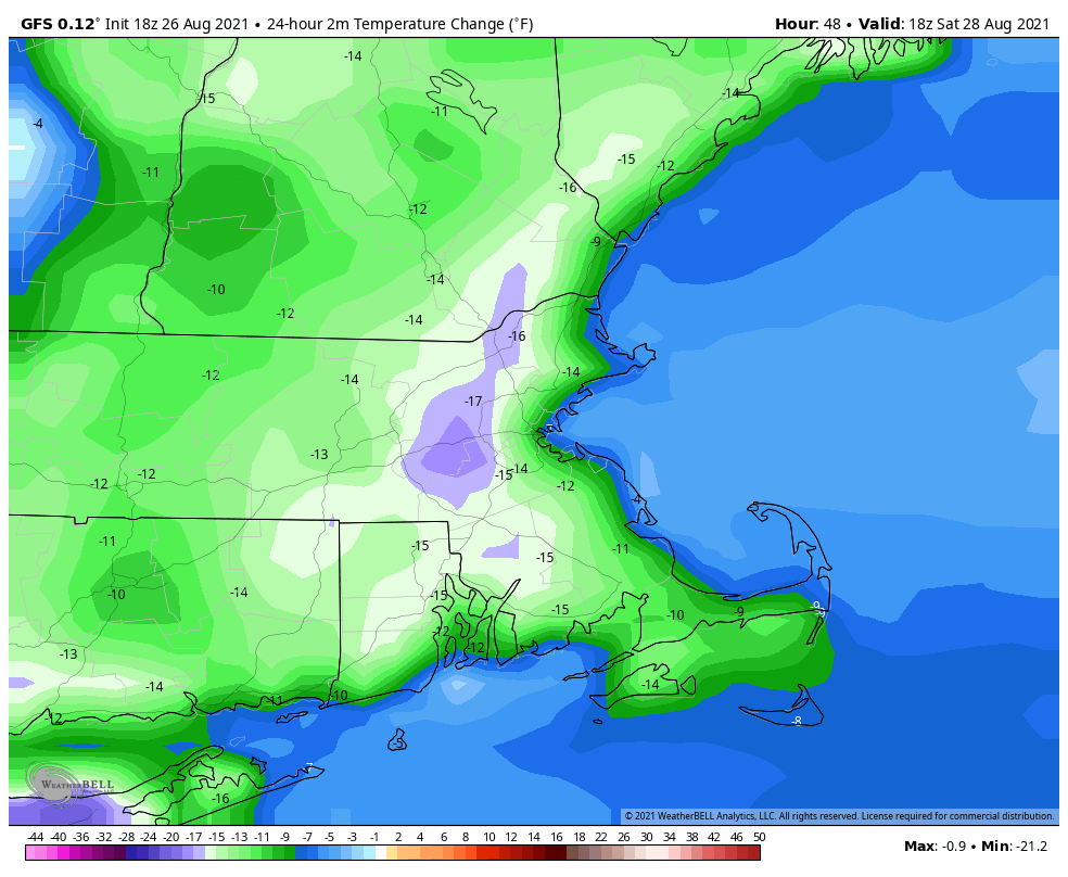
The heat and humidity will continue into Friday with high pressure offshore, but a backdoor cold front will drop southward by late in the day. As the winds shift into the east and northeast, much cooler air will settle into the region. The front may be accompanied by a few showers or thunderstorms, but much of the region should remain dry.
Temperatures Saturday afternoon could be as much as 10-20 degrees cooler than Friday afternoon. Image provided by WeatherBell.
That front will stall out just to our south for the weekend, keeping plenty of clouds in place along with the cooler temperatures. By later on Sunday, that front will start to lift northward again as a warm front. This may bring in a better chance for showers and thunderstorms for Sunday night and Monday, but it will also bring warmer and more humid weather back in.
Thursday night: Partly cloudy. Low 67-74.
Friday: A mix of sun and clouds, slight chance for a shower. High 85-92.
Friday night: Partly to mostly cloudy. Low 60-67.
Saturday: More clouds than sun. High 70-77, coolest along the coast.
Saturday night: Mostly cloudy. Low 57-64.
Sunday: Intervals of clouds and sun. High 72-79.
Sunday night: Partly cloudy, chance for a few showers. Low 62-69.
Monday: More clouds than sun with some showers and thunderstorms possible. High 79-86.
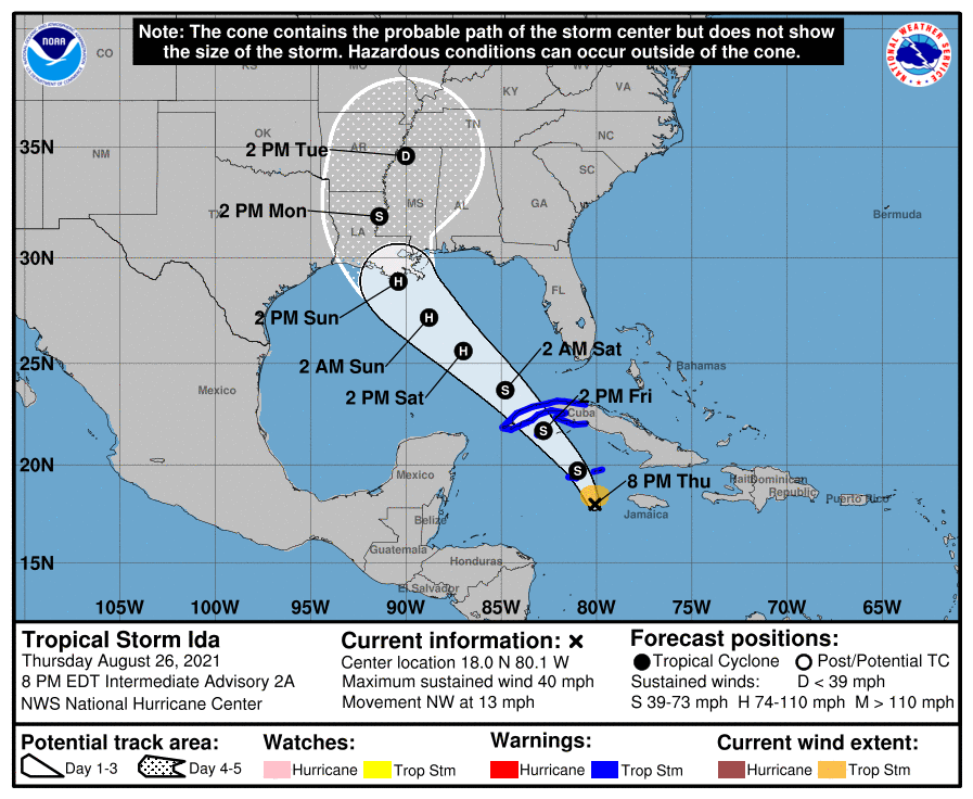
Forecast track for Tropical Storm Ida. Image provided by the National Hurricane Center.
Finally, a quick word on the tropics. Tropical Storm Ida has developed west of Jamaica. Current forecasts call for it to rapidly strengthen and head northwestward. It could become an increasing threat to parts of the Gulf coast, especially Louisiana or Mississippi, by late in the weekend as a hurricane, possibly a very strong one. There are two other areas, one east of Bermuda and another east of the Lesser Antilles, that could also become tropical depressions over the next few days.
Who’s ready for a nice quiet weekend weatherwise? Might I suggest a trip to Los Angeles then, because you’re not going to get one here, with or without Henri.
The remains of Tropical Storm Fred will continue to pull away this evening, but a few showers are still possible, otherwise, we’ll start to dry out a little overnight. However, warm and humid conditions will remain in place on Friday, with plenty of clouds and some sunny breaks, and possibly a few showers or thunderstorms. Saturday looks to be similar with some sunshine, but also some showers and thunderstorms possible as a warm and humid airmass remains in place. This brings us to Sunday and Monday, which is entirely dependent on the track of Henri.
Satellite loop of Tropical Storm Henri. Loop provided by NOAA.
As of 11am Thursday, Tropical Storm Henri was centered about 810 miles south of Nantucket, moving toward the west at 10 mph. Maximum sustained winds were near 70 mph. An Air Force Reconnaissance aircraft is investigating the storm right now to assess the true strength and structure of it. This should help improve the forecasts for the storm. Henri is fighting off some northerly wind shear as it moves around the edge of a ridge of high pressure, which is preventing it from strengthening. As it reaches the edge of the ridge tomorrow, it should turn more northward, and the shear will lessen. Combined with the fact that it will be over the warm waters of the Gulf Stream means that it should strengthen into a hurricane. As the same time, an upper-level low pressure area will develop over the Great Lakes, helping to steer Henri northward as well. This is where the largest uncertainty comes into play, and it has a giant impact on the forecast. Does the combination of the low to the west and ridge to the east remain strong and keeping Henri on a northward track, or does the ridge weaken a bit and allow Henri to turn more toward the northeast? If that wasn’t enough to complicate things, we also need to see how fast Henri is traveling at that point. The water off the Northeast coast is not warm enough to sustain a tropical system, so it will start to weaken. The faster it is moving, the less time it will have to weaken before reaching our latitude. These are questions that we can’t answer yet.
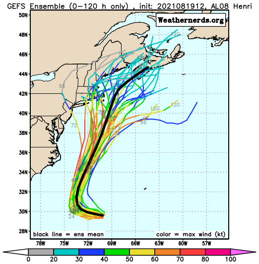
Forecast track for Henri from the various members of the GFS Ensemble. Image provided by Weathernerds.org
Since Henri formed, our thinking all along has been that it would pass close to or just south and east of Cape Cod, close enough for some impact across the Cape and Islands at least. That remains a plausible scenario. There are plenty of models that have landfall across Rhode Island or Southeastern Massachusetts as either a hurricane or strong tropical storm, and others that show no landfall and keep the storm offshore. Either way, it’s important to remember that as storms reach this latitude, they become lopsided, with most of the heavy rain to the left of the center, and the stronger winds confined to the right of the center. So, a track near or just off the Cape would spare most of the region from the strong winds, but result in heavy rainfall, especially across eastern Massachusetts. A track across southeastern Massachusetts would bring strong winds onto the Cape and Islands, and shift the heavy rain inland a bit more. The track will also impact the storm surge. With a full moon on Sunday, we’re already going to have astronomical high tides, which can create some coastal flooding on their own in spots. Add in a storm surge, and significant coastal flooding is likely, especially just to the right of the storm track. With all of these things possible, the National Hurricane Center will likely issue a Tropical Storm or Hurricane Watch for parts of the region on Friday.
Probability of tropical storm fore winds and the most likely arrival time. Image provided by the National Hurricane Center.
Most of the impacts from Henri are likely from Sunday afternoon into Monday morning, but again, this is dependent on the track and speed of the storm. Either way, conditions should start to improve Monday afternoon as Henri begins to pull away.
Thursday night: Partly to mostly cloudy, a few showers possible during the evening. Low 66-73.
Friday: Intervals of clouds and sunshine, chance for a shower or thunderstorm. High 79-86. Offshore: Southwest 10-15 knots, gusts to 20 knots seas 3-5 feet.
Friday night: Partly cloudy, patchy fog may develop. Low 66-73.
Saturday: Partly sunny, a few showers and thunderstorms are possible in the afternoon. High 81-88. Offshore: Southeast 5-10 knots, seas 2-4 feet.
Saturday night: Mostly cloudy. Low 65-72.
Sunday: Cloudy and becoming breezy with some showers developing, possibly becoming a steadier and heavier rain late in the day. High 72-79. Offshore: Tropical storm conditions likely
Sunday night: Breezy to perhaps windy with rain, possibly heavy. Low 62-69.
Monday: Diminishing winds with rain tapering off to showers and ending, some sunny breaks may develop in the afternoon. High 74-81. Offshore: Tropical storm conditions likely, subsiding late in the day.
Heat and humidity are here for now, but changes are on the way this weekend.
High pressure remains anchored off the East Coast into Friday, which means that another hot and humid day is on the way. A few showers and thunderstorms may pop up to take the edge off the heat, but they’ll be mainly late in the day. A cold front will move in on Saturday though, with more widespread showers and thunderstorms. Behind the front, much drier and cooler air will start to move in late Saturday. High pressure builds in for Sunday and Monday with seasonably warm and dry conditions.
The heat index may approach 100 across parts of the region again Friday afternoon. Image provided by WeatherBell.