Memorial Day Weekend is the unofficial start, and the weather couldn’t be much better than what we’ll have.
One thing we won’t have much of this weekend is clouds. Loop provided by Pivotal Weather.
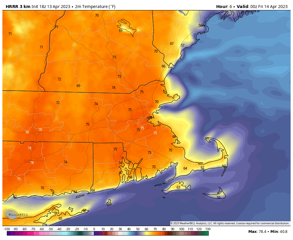
High pressure will build in north of the region, and slowly drift eastward over the next few days. We’ll start off the weekend with a rather cool night tonight, but temperatures will moderate over the next few days, with Sunday and Monday likely to see 80s in many areas away from the coast. For the most part, we’ll have sunshine each day, though some high-level haze and smoke may drift through at times. We also need to keep an eye on a low pressure area off the Southeast coast. While the high to our north should block its northward progress, some high clouds on the northern fringe of it could reach the South Coast toward Sunday and Monday, which would be the only blemish on the weekend forecast.
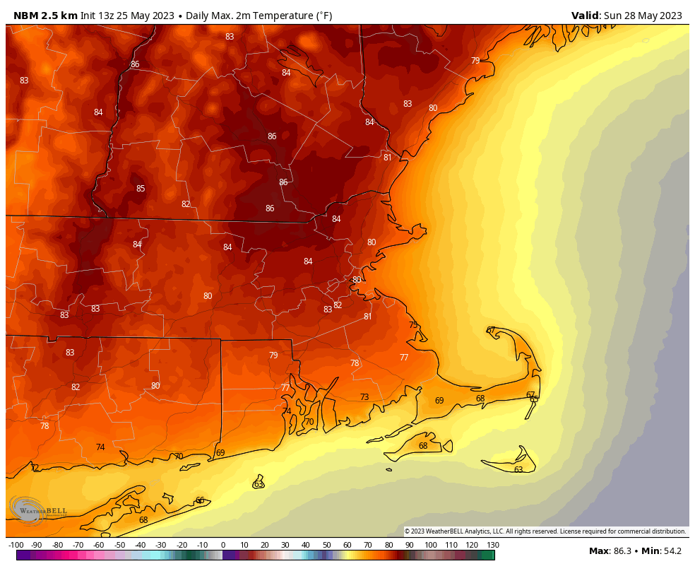
Sunday looks like the warmest day of the weekend, with widespread 80s away from the coast. Images provided by WeatherBell.
Thursday night: Clear and cool. Low 40-47.
Friday: Mostly sunny, milder. High 65-72, cooler along the coast.
Friday night: Clear skies. Low 43-50.
Saturday: Plenty of sunshine, warmer. High 72-79, cooler near the South Coast and Cape Cod.
Saturday night: Clear skies. Low 48-55.
Sunday: More sunshine, a little breezy. High 79-86, cooler near the South Coast and Cape Cod.
Sunday night: Low 53-60.
Memorial Day: Sunshine and possibly some high clouds, a little breezy at times. High 74-81, a little cooler near the coast.
Some much-needed rain is coming this weekend, but don’t fret, it won’t ruin the entire weekend.
Record lows were set in numerous locations across the Northeast this morning, but temperatures will moderate over the next few days. Image provided by coolwx.com
Offshore high pressure remains in control for tonight and Friday, with dry and milder weather likely. We’ll still have smoke from wildfires in Canada dimming the sun at times on Friday, but overall it will be a nice day. Clouds will move in at night though as a pair of systems begin to head our way. A cold front will be moving in from the west, while a weak low pressure system moves up the East Coast. There are still some mixed signals with the coastal low for Saturday, which has a big impact on the forecast. Some models have that system send a batch of rain in for Saturday afternoon, others keep the rain either offshore, or confined to Cape Cod. We’re leaning towards the latter scenario at the moment. The cold front then moves through Saturday night with some showers along and ahead of it. High pressure then builds in for Sunday and Monday with dry and seasonably warm conditions, but we may still have some smoke drifting through, dimming the sun at times.
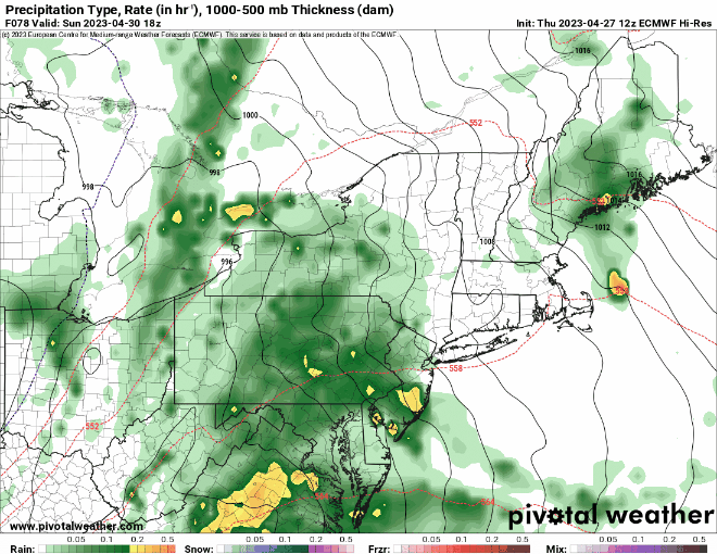
Many of the models are forecasting a bout of heavy rain this weekend, some keep the heavy rain to Cape Cod only. We’re leaning toward the latter. Images provided by Pivotal Weather.
Thursday night: Clear skies. Low 39-46.
Friday: Sunshine filtered through high-level smoke, clouds start to move in during the afternoon. High 66-73, a little cooler along the South Coast.
Friday night: Becoming mostly cloudy. Low 47-54.
Saturday: Cloudy and breezy with some showers likely. High 62-69.
Saturday night: Mostly cloudy with more showers, ending before daybreak. Low 52-59.
Sunday: Becoming partly sunny, smoke may filter the sun at times, breezy. High 69-76.
Sunday night: Partly cloudy. Low 47-54.
Monday: Plenty of sunshine, breezy. High 61-68, coolest near the coast.
After a rather cool and damp week thus far, the weather will improve in time for the weekend.
The stubborn low pressure area that has been plaguing the region for much of the week will finally start to move out tonight, which slow improvement on Friday, and much better weather coming for the weekend. Not only will the rain end, but temperatures will get back to near to even above normal levels for early May.
For now, Monday looks like a fantastic day across the region. Image provided by Weathermodels.com
Thursday night: Cloudy with some drizzle and a few showers. Low 38-45.
Friday: Clouds and a few showers or drizzle gradually give way to some afternoon sunshine. High 52-59, coolest along the coast.
Friday night: Clearing. Low 40-47.
Saturday: Sunshine and some afternoon clouds. High 63-70.
Saturday night: Clear to partly cloudy. Low 44-51.
Sunday: Sunshine and a few clouds around. High 66-73.
Friday is looking like a really nice day, so you’d better enjoy it, because the rest of the weekend isn’t looking so great.
Drought conditions are beginning to develop across parts of the region. This weekend’s rain will help alleviate that. Image provided by the National Drought Mitigation Center.
The upper-level low pressure that’s been hanging around all week will finally move away and high pressure builds in tonight into Friday with drier and milder conditions. Friday like starts with some sunshine, but clouds will increase and thicken up during the afternoon and evening as low pressure begins to slowly move this way. The high will keep the rain shield from the low at bay for a while, but showers should eventually develop Saturday afternoon and continue into Sunday morning. Sunday may not be that bad of a day, but it certainly isn’t looking great. As the first system moves out, a second, more potent one, will begin to approach. Most of the rain from that system will hold off until Sunday night, so the bulk of Sunday will be just cloudy, but there will be enough moisture around for some drizzle and possibly a few showers. Rain is likely Sunday morning, ending by midday Monday, with some sunny breaks developing in the afternoon.
Sunday afternoon may end up dry, but not all the models agree on that. Images provided by Pivotal Weather.
Thursday night: Becoming clear to partly cloudy with areas of fog developing. Low 36-43.
Friday: Some morning sun, then clouds increase and thicken up. High 58-65, coolest along the coast.
Friday night: Mostly cloudy. Low 40-47.
Saturday: Cloudy and becoming breezy with showers developing during the afternoon. High 51-58.
Saturday night: Periods of rain and showers, breezy. Low 42-49 during the evening, temperatures may rise a bit after midnight.
Sunday: Rain tapers off in the morning, still some showers or drizzle around during the afternoon, still breezy. High 57-64.
Sunday night: Windy with rain redeveloping. Low 47-54.
Monday: Showers end in the morning, some clearing during the afternoon, breezy again. High 61-68.
Glass half-full or glass half-empty? Which is your point of view? That’ll help you decide whether the weekend will be good or not so good.
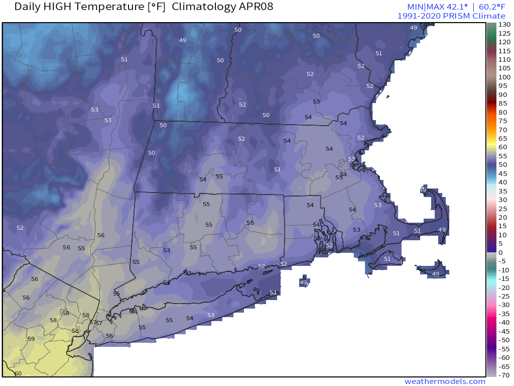
Average high temperatures for mid-to-late April around here are close to 60 degrees. Images provided by Weathermodels.com
High pressure slides off to the east, with another sunny day expected on Friday. Temperatures will be mild away from the shoreline, but a seabreeze will keep coastal areas on the cool side once again. Clouds will start to stream in Friday night ahead of a warm front, but we’re not sure that front ever makes it across the region. Saturday looks to feature plenty of clouds, and maybe even a little drizzle, with seasonably cool temperatures, especially the closer to the coastline you get. Low pressure heads into southeastern Canada Saturday night into Sunday, dragging a slow-moving cold front toward the region. Showers will move in ahead of the front Saturday night. To the amateur, looking at the models you would forecast Sunday to be a washout, but that is likely not the case. We’ll have occasional periods of rain, especially during the morning, but it won’t be all day, and in fact, a good chunk of the day, especially in the afternoon, could end up dry. When it does rain though, some of it could be heavy. Since it’s been rather dry lately, we actually do need the rain, so despite it falling on a weekend, it’s not completely bad. Temperatures will be on the cool side once again thanks to the clouds, rain, and gusty onshore winds. The cold front moves offshore later Sunday, but an upper-level low moves into the Northeast on Monday, meaning we’ll still have plenty of clouds, more showers at times, and breezy and cool conditions. This is Mother Nature’s way of reminding you that despite our summer preview a week ago, it is still April in New England.
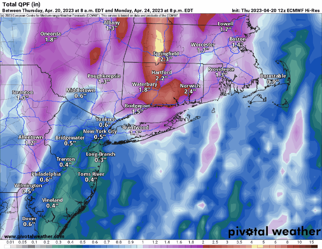
The models have been overestimating rainfall around here for quite some time, but we still should get some much needed rainfall this weekend. Images provided by Pivotal Weather.
Thursday night: Clar to partly cloudy. Low 36-43.
Friday: Sunshine and a few clouds. High 55-62 near the coast, 63-70 inland.
Friday night: Becoming mostly cloudy. Low 39-46.
Saturday: Mostly cloudy and breezy, a little drizzle is possible. High 55-62, a little cooler near the coast.
Our early summer preview will last for another day for parts of the region, but April will be coming back rather quickly.
It’s a very warm afternoon across the region. Image provided by NOAA.
High pressure remains in place offshore, keeping most of the region very warm for the rest of today and tonight, and into the day on Friday. However, a backdoor cold front will start to move inland during the day on Friday, which means that coastal areas will quickly turn cooler, with inland areas likely staying warm again Friday, cooling off late in the day. While some inland locations could make a run at 90 during the afternoon, coastal locations may drop into the 50s at the same time. That front likely stalls out at some point on Saturday, keeping most of us on the cooler side, with temperatures in the 50s to lower 60s, which is close to normal for mid-April. South and west of the front, it’ll be another warm day, but this is mostly likely for areas from the Connecticut Valley south and west. A weak disturbance moves through for Saturday night and Sunday with a few showers, mainly south of the Mass Pike. However, with plenty of clouds and some showers around, temperatures will stay in the 50s for most of us.
Temperatures quickly plunge Friday afternoon as the backdoor cold front moves in. Loop provided by WeatherBell.
This brings us to Monday – Patriots Day, when weather will be very important, since we have both the Boston Marathon and the Red Sox traditional 11am game, as well as other assorted activities such as the reenactments of Paul Revere’s ride and the first shots of the Revolution in Lexington and Concord. We also have the Bruins 1st playoff game at night, but the weather won’t impact that. A cold front will bring moving into the region, bringing some rain, but the timing is still in question. Some models have showers in the morning, some hold off the rain until afternoon. Obviously, that makes a huge difference, so we’ll be keeping an eye on that as we go through the weekend.
When will the rain arrive on Monday? The models don’t agree. Images provided by Pivotal Weather.
Thursday night: Clear through the evening, some clouds may start to drift in after midnight. Low 56-63.
Friday: Partly to mostly sunny. High 72-79 along the coast, 80-87 inland, but temperatures will drop sharply in the afternoon, especially closer to the coast.
Friday night: Increasing clouds. Low 44-51.
Saturday: More clouds than sun, a few showers possible late in the day, mainly south of the Mass Pike. High 57-64 near the coast, 65-72 inland.
Saturday night: Mostly cloudy with some showers likely, again mostly south of the Mass Pike. Low 45-52.
Sunday: Mostly cloudy and breezy with showers likely, mainly across eastern Massachusetts and Rhode Island and mainly during the morning. High 52-59.
Sunday night: Mostly cloudy. Low 44-51.
Patriots Day: Mostly cloudy and breezy with showers likely, especially during the afternoon. High 59-66, cooler along the coast.
An extended stretch of dry weather is expected through the weekend and into next week.
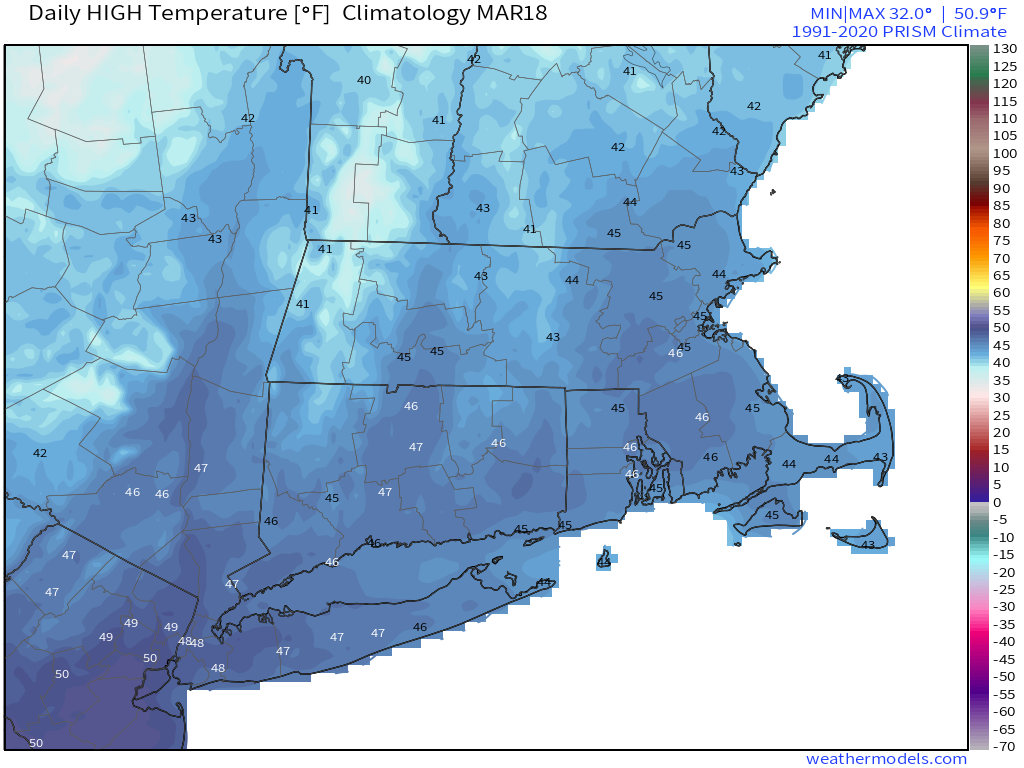
Average high temperatures for early April are in the lower to middle 50s. Image provided by Weathermodels.com
A cold front will move across the region this evening, producing some showers and possibly thunderstorms. Once the front moves offshore, high pressure will build in for Friday, though we’ll still have a decent amount of cloudcover as a upper-level trough of low pressure swings across the Northeast. Skies will clear out Friday night, resulting in a rather chilly night as winds diminish. Saturday will feature plenty of sunshine, though temperatures will be on the cool side. Sunday looks fairly similar, though temperatures will be a few degrees warmer as the high moves off to the east and southwest winds bring milder air in. Monday looks to be even milder under partly to mostly sunny skies. In fact, much of next week looks dry and warm for the most part, with temperatures likely getting into the 70s by midweek, and there’s a chance we could be talking about highs near or above 80 by the end of the week.
Much of next week is looking very warm across the Northeast. Image provided by WeatherBell.
Thursday night: Mostly cloudy, showers and thunderstorms ending. Low 39-46.
Friday: Intervals of clouds and sunshine, breezy. High 52-59.
Friday night: Partly cloudy. Low 26-33.
Saturday: Sunshine and a few clouds. High 44-51.
Saturday night: Clear skies. Low 27-34.
Sunday: Plenty of sunshine. High 47-54.
Sunday night: Clear skies. Low 30-37.
Monday: Mostly sunny. High 57-64, cooler along the South Coast.
Half of the upcoming weekend looks decent weather-wise, but that means that half the weekend won’t be so nice.
A warm front will approach the region today, with clouds streaming in, and rain developing by late afternoon. The rain may start as some sleet or wet snow across the hills of central Massachusetts and southwestern New Hampshire, but even there, a change to rain is expected with little accumulation. Temperatures rise behind the front at night, and the rain comes to an end, but as second round of rainfall is likely on Saturday in the warm air. Don’t be shocked if some thunderstorms develop as well as a cold front approaches. The front moves through in the evening then high pressure builds in for Sunday with sunshine and chilly conditions once again. As the high moves offshore, temperatures will moderate on Monday.
Around 1 inch of rain is expected late Friday and Saturday across the region. Image provided by WeatherBell.
Thursday night: Clear skies, clouds start to filter in late at night. Low 22-29.
Friday: Becoming cloudy and breezy with showers developing in the afternoon, possibly some sleet or wet snow in the hills. High 44-51.
Friday night: Cloudy and breezy with rain tapering off in the evening, showers redevelop late at night. Low 37-44 during the evening, temperatures will start to rise overnight.
Saturday: Partly to mostly cloudy and windy with rain likely, possibly a thunderstorm. High 57-64, cooler along the South Coast.
Saturday night: Mostly cloudy and breezy with showers ending in the evening, some clearing late at night. Low 31-38.
Sunday: Plenty of sunshine, windy, and cooler. High 41-48.
We’ve got some unsettled weather coming our way for the next few days.
Some showers are likely through the evening before a cold front crosses the region overnight. We’ll see some clearing on Friday as high pressure tries to build in, but with the front stalled out just to the south, some clouds will linger, especially near the South Coast. Gusty winds behind the front will usher some cooler air in. Friday night will be on the chilly side with lighter winds and clear skies allowing for radiational cooling. Clouds quickly return on Saturday ahead of another storm system. While this one will be mainly rain, it may start as some snow, especially north and west of I-495. Some slushy accumulations are possible, but a change to rain will wash them away by late in the day. Rain comes to an end Sunday morning, then high pressure builds in for the rest of Sunday and Monday with dry and seasonable conditions.
Most of the models show precipitation beginning as a wintry mix outside of I-495 Saturday afternoon. Images provided by Pivotal Weather.
Thursday night: Partly to mostly cloudy with showers ending before midnight, breezy. Low 35-42.
Friday: Partly sunny, breezy in the morning. High 47-54.
Friday night: Partly cloudy. Low 27-34.
Saturday: Mostly cloudy and breezy with showers developing, starting as some wet snow outside of I-495 before changing to rain. High 39-46.
Saturday night: Mostly cloudy and breezy, with rain likely. Low 32-39 during the evening, temperatures may rise a bit overnight.
Sunday: Showers end early, then becoming mostly sunny, windy. High 51-58.
Sunday night: Clear skies, breezy. Low 30-37.
Monday: Sunshine and a few clouds, still breezy. High 46-53.
The final weekend of astronomical winter will be a fairly quiet one across the region.
Astronomical Spring begins with the Vernal Equinox at 5:24pm Monday. Image provided by EarthSky.org
Clouds start to stream into the region tonight ahead of a warm front. A few showers are likely on Friday as the front moves across the region,, but it will be quickly followed by a cold front early Saturday, which may produce a few more showers. We’ll clear out behind the cold front on Saturday, but the colder air will take its time moving in, so we’ll have another mild day, which shouldn’t interfere with any St. Patrick’s Day celebrations. High pressure settles in for latter half the weekend with dry and cooler weather on Sunday, but temperatures will start to moderate for Monday.
Normal high temperatures for mid-March are generally in the middle 40s for our area. Image provided by Weathermodels.com
Thursday night: Partly cloudy through the evening, clouds increase after midnight. Low 27-34.
Friday: Mostly cloudy and becoming breezy with a few late-day showers. High 47-54.
Friday night: Mostly cloudy, chance for a few showers, mainly during the evening. Low 33-40.
Saturday: A few showers early, then becoming partly sunny, breezy. High 46-53.
Saturday night: Clear to partly cloudy, breezy. Low 22-29.
Sunday: A mix of sun and clouds, windy, and cooler. High 34-41.
Sunday night: Clear skies, breezy. Low 20-27.
Monday: Plenty of sunshine, breezy again. High 42-49.