Sunday was the first day of fall, and we’ll have some fall weather for most of the upcoming week.
Temperatures will be a little cooler than normal over the next several days. Image provided by Weathermodels.com
The low pressure system that brought all the rain and cool weather to the region over the weekend has drifted off to the south, and high pressure has built in from the north, which will bring us some drier weather for the next few days. However, the flow in between the two systems will result in northeast winds, keeping us cool, while also keeping some clouds around. By Wednesday, we’ll see a frontal system start to approach from the west, bringing more clouds in. It looks like most of the rain should hold off until night time, so Wednesday should be another dry day. That system will be a slow mover though, so another wet day is likely on Thursday. High pressure builds in for Friday and the weekend with drier air, but it’s not as simple as that may sound.
The models are in good agreement that we should get some beneficial rainfall Wednesday night and Thursday. Image provided by Pivotal Weather.
A tropical system is likely to develop in the Gulf of Mexico over the next day or two, and forecast models show it becoming a formidable system before landfall somewhere between New Orleans and Tampa later this week. Once inland, it will rapidly weaken, but the moisture from it will stream northward. Some models have the high pressure area block that moisture from getting up here, while other models have it get close, possibly to the South Coast, before the high blocks any farther progress northward. So, for now, our forecast is for dry weather next weekend, but that could change by the time we get to our Weekend Outlook on Thursday.
Most of the Ensemble members are in good agreement on a track toward the Florida Panhandle later this week with a developing tropical system. Loop provided by Tomer Burg.
Monday: More clouds than sunshine, breezy near the coast. High 60-67.
Monday night: Partly to mostly cloudy. Low 48-55.
Tuesday: Intervals of clouds and sun, breezy near the coast. High 61-68.
Tuesday night: Mostly cloudy. Low 50-57.
Wednesday: Plenty of clouds, slight chance for a shower during the day, more likely at night. High 62-69.
Thursday: Cloudy with showers likely, ending late in the day. High 64-71.
That line from “Time Stand Still” by Rush, often describes late August or September around here, and it will for at least part of this week.
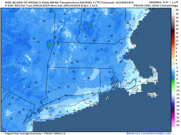
Temperatures will be below normal for the next several days. Image provided by Weathermodels.com
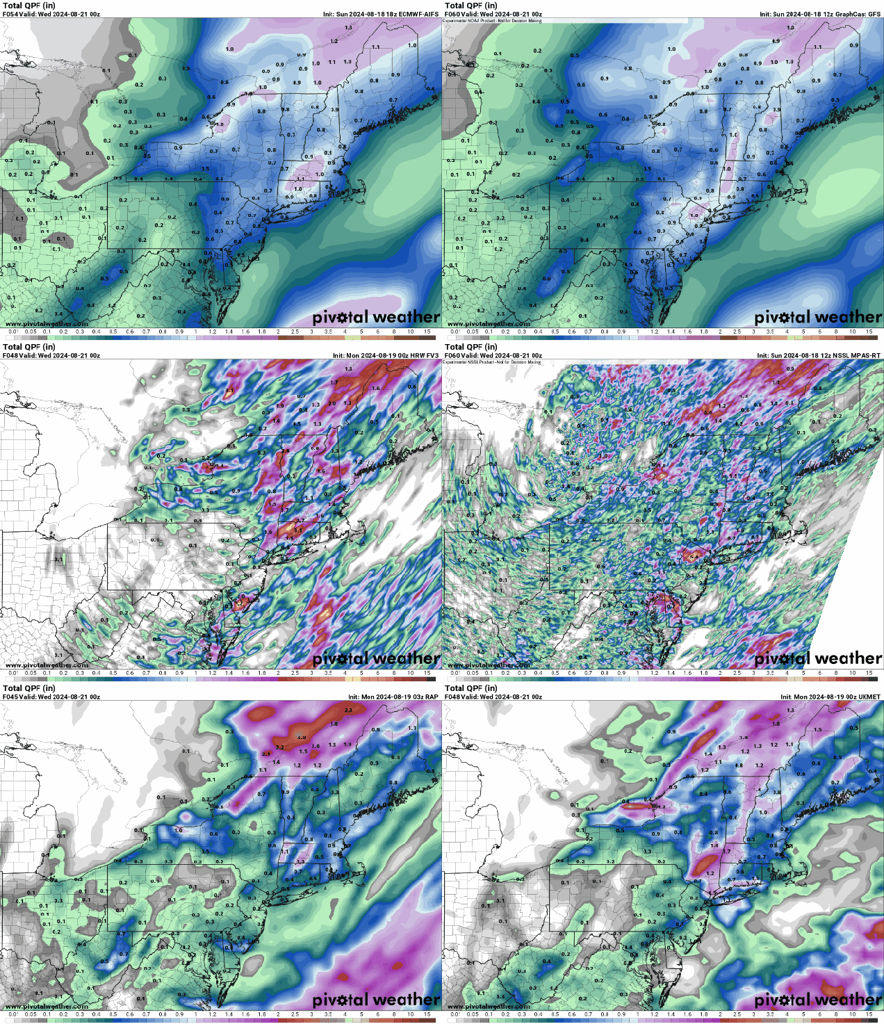
We’re starting the week off with a slow-moving cold front making its way across the region, resulting in aa fairly damp Monday with occasional showers and a few embedded thunderstorms. The front moves offshore early Tuesday, with showers coming to an end, and some clearing behind the front by late in the day as high pressure starts to build in. However, an upper-level low pressure system will then settle into the Northeast for Wednesday and Thursday. As a result, both days will start off with some sunshine, then clouds will develop, with a few showers possible each afternoon. Temperatures will be quite cool, with many places likely staying in the 60s for highs. We could even see a few of the normally cooler locations drop into the 40s at night. As the upper low moves out and high pressure slides offshore, we’ll start to warm up for the end of the week and the weekend, with temperatures getting back to near to above normal levels. Another system could move in by the end of the weekend with some unsettled weather, but the more likely scenario is that it holds off until the start of next week.
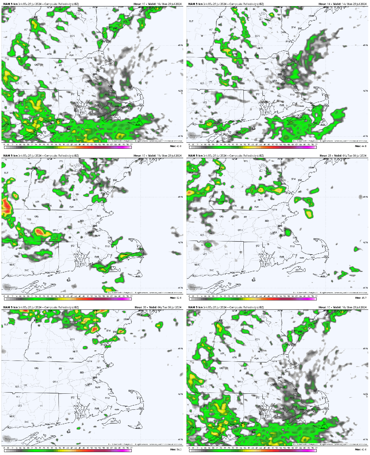
There may be some downpours today, but most of the models do not show significant rainfall for our area. Images provided by Pivotal Weather.
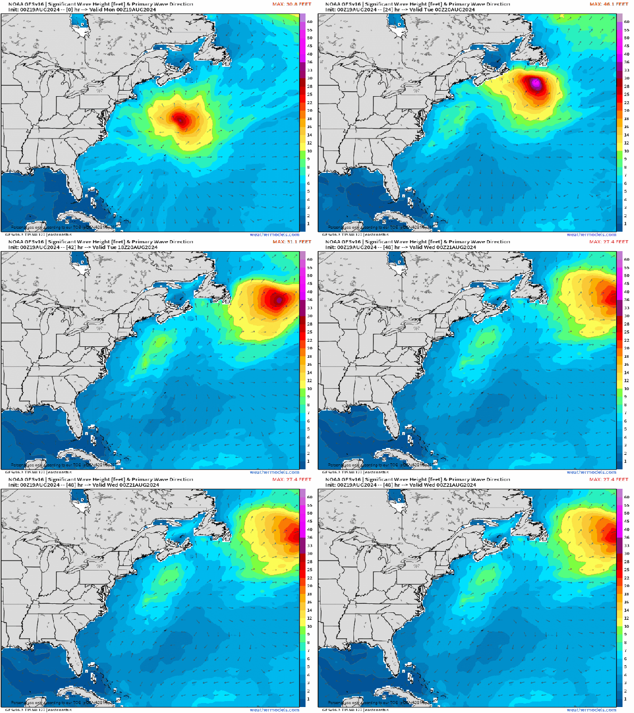
Hurricane Ernesto will continue to generate large swells at the beaches for a few more days, so use caution if you have plans near the coast. As of 11pm Sunday, Ernesto was centered about 435 south-southeast of Halifax, Nova Scotia, moving off toward the north-northeast at 20 mph. Maximum sustained winds were near 80 mph. Ernesto is expected to turn more toward the northeast and east-northeast today, passing south of Newfoundland tonight as it becomes extratropical.
Ernesto will continue to generate large waves in the North Atlantic for a few more days. Loop provided by Weathermodels.com
Finally, we’d like to acknowledge that today marks the 33rd anniversary of Hurricane Bob making landfall along the South Coast. We’ve had some close calls in the years since then, but have not had a hurricane make landfall in New England or Long Island since Bob. This is the 2nd longest landfall drought on record for the region. Since 1851, 18 hurricanes have made landfall in this area, or one every 9.6 years, so we are very overdue. Of the 18 hurricanes that made landfall in New England or Long Island since 1851, 15 of them have done so between August 19 and September 27, so this is the time of year that we need to be especially vigilant, though the Atlantic looks to remain quiet for at least the next week or so.
Track of Hurricane Bob, August 16-19, 1991. Image provided by the National Weather Service.
Monday: Mostly cloudy with occasional showers, a rumble or two of thunder, and a few breaks of sunshine. High 74-81.
Monday night: Partly to mostly cloudy with a few more showers. Low 57-64.
Tuesday: Any lingering showers end early, some clearing develops late in the day. High 67-74.
Tuesday night: Becoming clear. Low 50-57.
Wednesday: A mix of sun and clouds, chance for a few showers. High 65-72.
Thursday: Sunshine and some afternoon clouds, chance for a shower or two. High 67-74.
Most of the weekend should feature some nice weather, thanks to Hurricane Ernesto.
Monday will feature some rather cool temperatures thanks to some rain. Image provided by Weathermodels.com
An upper-level low over Atlantic Canada will lift back out tonight, with any lingering showers or thunderstorms ending this evening. High pressure then builds in for Friday and Saturday with drier weather, though smoke drifting down from Canadian wildfires will dim the sun at times. Another upper-level low will settle into the Great Lakes, with a surface low pressure and its associated cold front slowly making their way eastward over the next few days. Hurricane Ernesto will be heading north and then northeastward well east of the region this weekend, but it will act to slow down the front, keeping us on the dry side. Some clouds will move in ahead of it, but it looks like the shower and thunderstorm activity associated with the front will hold off until late Sunday. As the front moves in, showers and thunderstorms will become more widespread Sunday night and Monday before the front moves offshore later Monday.
A slowing moving cold front will produce heavy rain at the end of the weekend, but the heaviest will stay to our west. Images provided by Pivotal Weather.
As for Hurricane Ernesto, it has Bermuda in its crosshairs at the moment. As of 5pm, Ernesto was centered about 495 miles south-southwest of Bermuda, moving toward the north at 13 mph. Maximum sustained winds were near 85 mph. The forecast calls for Ernesto to strengthen a little more tonight and Friday while heading northward, passing very close to Bermuda Friday night and early Saturday as it slows down. Beyond that, it will start to turn more toward the northeast, gradually weakening as it loses its tropical characteristics this weekend while passing south of Atlantic Canada. It could bring some heavy rain and gusty winds to parts of Newfoundland, but the bigger impact it will have, except for what it does to Bermuda, will be the large swells it generates. Rough seas are likely this weekend, with large waves smashing into the East Coast from the Carolinas northward to Atlantic Canada, resulting in hazardous conditions at the beaches and a high risk for rip currents, as well as the threat for some coastal flooding near the time of high tide, as we are approaching the astronomical high tides for the month.
Forecast track for Hurricane Ernesto. Image provided by the Canadian Hurricane Centre.
Thursday night: Showers and thunderstorms end this evening, partly to mostly cloudy overnight with areas of fog developing. Low 59-66.
Friday: A mix of sun and clouds, smoke from Canadian wildfires will dim the sun at times. High 77-84, coolest along the coast.
Friday night: Partly to mostly cloudy, patchy fog possible again. Low 60-67.
Saturday: Hazy sunshine and some afternoon clouds. High 77-84.
Saturday night: Partly to mostly cloudy. Low 62-69.
Sunday: More clouds than sun, some showers and thunderstorms may develop in the afternoon. High 75-82.
Sunday night: Cloudy with showers and thunderstorms becoming more likely. Low 62-69.
Monday: Plenty of clouds with more showers and thunderstorms. High 73-80.
Tropical Storm Ernesto developed just east of the Leeward Islands on Monday and crossed the Virgin Islands late Tuesday.
Tropical Storm Ernesto began to get organized as it crosses the US Virgin Islands late Tuesday. Loop provided by NOAA.
The disturbance we had been watching for several days finally got itself organized enough to be classified as Tropical Storm Ernesto late Monday afternoon. The storm passed very close to Guadeloupe as it crossed the Leeward Islands Tuesday morning, producing wind gusts as high as 65 mph on St. Barthelemy. The storm crossed the US Virgin Islands Tuesday evening, producing a gust to 79 mph on Buck Island in St. Thomas. As it pulled away, it produced sustained winds of 68 mph and a gust to 86 mph on Culebra, just off the northeastern coast of Puerto Rico. As of 5am EDT, Ernesto was centered about 85 miles north-northwest of San Juan, Puerto Rico, moving toward the northwest at 16 mph. Maximum sustained winds had increased to 70 mph.
Ernesto was still rather disorganized when crossing the Leeward Islands early Tuesday. Loop proovided by Brian McNoldy, Univ. of Miami, Rosenstiel School
A trough of low pressure moving off the East Coast will help turn Ernesto northward over the next day or two, passing northeast of Puerto Rico overnight and early Wednesday. Upper-level conditions will be favorable for development, and with very warm water in the western Atlantic, Ernesto could rapidly strength once it gets a little better organized. The current forecast calls for Ernest to become a hurricane later today, and it could become a major hurricane before the end of the week. As a ridge of high pressure tries to build back in, Ernesto may slow down a bit toward the end of the week as it starts to approach Bermuda. The current forecast calls for Ernesto to pass very close to Bermuda late Friday or Saturday as a Category 2 or 3 hurricane. However, it is important to note that forecast errors with tropical systems can be quite large, in terms of both track and intensity that far out. Still, anyone on Bermuda or with plans to head there late this week should pay very close attention to Ernesto’s progress.
Forecast track for Tropical Storm Ernesto. Image provided by the National Hurricane Center.
Once past Bermuda’s latitude, another trough of low pressure will move off the East Coast, which should help to steer Ernesto off toward the northeast and eventually east. The question is, how close does Ernesto get to Nova Scotia and/or Newfoundland. This is still a week or so away, and Ernesto will almost certainly be extratropical by that point, but it is impossible to tell what, if any, impact Ernesto may have on Atlantic Canada, but again, residents of these areas should keep a close eye on the storm. Large swells generated by Ernesto will begin to impact much of the East Coast later this week and this week, creating rough seas offshore, and the risk for rip currents and possibly coastal flooding as well, as tides reach astronomical highs this weekend and early next week. Keep this in mind if you have beach plans this weekend anywhere in the Northeast or Mid-Atlantic states.
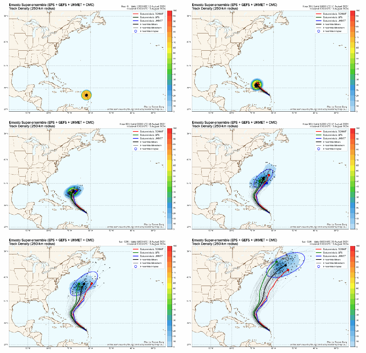
Model ensembles show a threat to Bermuda and possibly Atlantic Canada by early next week. Loop provided by Tomer Burg.
Ernesto generated a lot of hype before it even developed. Several forecast models showed the potential for the storm to develop into a potent hurricane and possibly threaten the East Coast. In turn, these maps got shared all across social media, spreading the hype. While the models can be helpful tools, their effectiveness, especially out 10-14 days as these forecasts were, is very limited. The model ensembles, which are essentially multiple versions of the same model run anywhere from 20-100 times with slight tweaks, showed the more likely scenario that actually played out, of a storm staying well off the East Coast. As you can see in the map above, none of the dozens of ensemble members show a threat to the East Coast at this point. Next time you see someone sharing a map that shows a storm threatening the East Coast two weeks in advance, keep this in mind. This is no different than in the winter when a model shows a paralyzing blizzard for the Northeast 10-14 days in advance, and it doesn’t materialize.
If you picked this week to take a vacation, then you’re in luck, because most of the week will feature some fantastic mid-August weather.
Temperatures this week will be pretty close to where they should be in mid-August. Image provided by Weathermodels.com
Most of the week will feature seasonably warm temperatures, moderate humidity, and dry weather, with high pressure in control. There are a few exceptions though. One of them is today, when a weak upper-level disturbance moves across the Northeast. It will generate a few more clouds, and possibly a few showers, but they shouldn’t be too widespread. Thursday will be similar with another disturbance generating a few pop-up showers, but again, nothing to cancel outdoor plans over. The weekend is when things become a little more uncertain. A cold front will be moving in from the west. Saturday should be another dry, but likely warm and a bit more humid, day. Sunday, however, may not be as nice, depending on the timing of the front. We could see more clouds and a better chance for showers and thunderstorms, though at least one model delays the front until the beginning of next week, so there’s a chance Sunday could end up dry as well.
Sunday may feature showers or thunderstorms, or maybe it won’t. Depends which model your trust. Images provided by Pivotal Weather.
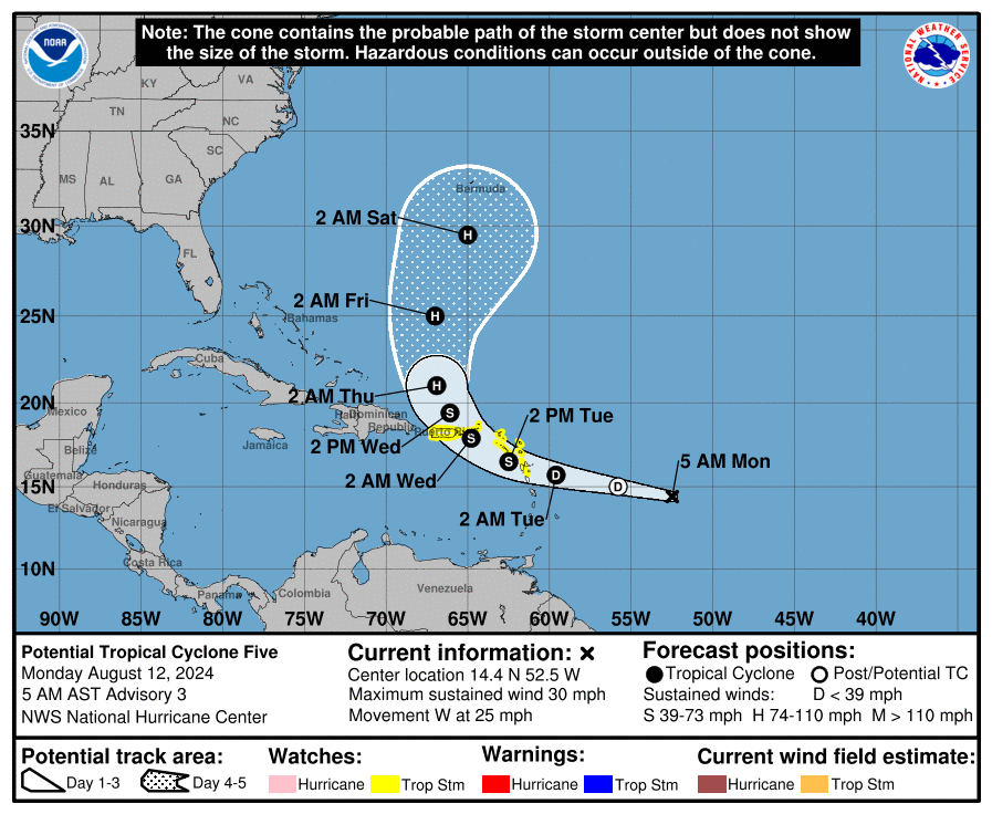
Finally, we’ll touch on the tropics. The hype train is already rolling down the tracks about “soon-to-be Ernesto”, and the threat is presents to the East Coast. Well, that’s not exactly the case. Yes, a couple of models a few days ago showed the potential for the storm to threaten the East Coast in about 10 days, but as of now, there is no actual storm to begin with. Sunday evening, the National Hurricane Centered designated the system as “Potential Tropical Cylone Five”. It still has a broad circulation, but it could become a tropical depression later today, assuming it can develop a low-level circulation. Conditions are not that favorable at the moment, but should become more conducive for development later today and Tuesday. The forecast calls for it to cross the Leeward Islands on Tuesday, then across the Virgin Islands Tuesday night and Wednesday, before turning northwestward and then northward. Tropical Storm Watches are in effect for the Leeward Islands and the British and US Virgin Islands as well as Puerto Rico. The forecasts calls for it to become a hurricane toward the middle of the week, and with additional strengthening possible, it could become a significant threat to Bermuda by next weekend. Of course, a lot can change between now and then, but at this point, the threat to the East Coast is minimal, despite all the recent hype. We’ll go into more detail on this system in a separate blog post once it has actually developed.
Forecast track for Potential Tropical Cyclone Five. Image provided by the National Hurricane Center.
Monday: A sunny start, then some clouds move in with a few showers possible in the afternoon. High 75-82.
Monday night: Any lingering showers end in the evening, then skies become clear. Low 56-63.
Tuesday: Sunshine and some afternoon clouds. High 77-84.
Tuesday night: Partly cloudy. Low 58-65.
Wednesday: Partly to mostly sunny. High 78-85.
Thursday: A mix of sun and clouds, chance for a few showers. High 76-83.
Friday: Partly to mostly sunny. High 77-84.
Saturday: Partly sunny, a little more humid, chance for some late-day showers. High 76-83.
Sunday: Intervals of clouds and sun with a chance for showers and thunderstorms. High 74-81.
Despite what the app on your phone says, most of the weekend will actually be rather pleasant.
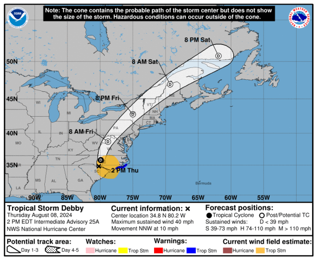
What’s left of Debby will pass well north and west of us Friday night. Images provided by the National Hurricane Center.
What’s left of Debby will head northward tonight, sending a warm front across the region. Some showers may accompany it, but you’ll notice humidity levels increasing once again. Temperatures may actually rise a few degrees overnight as winds shift into the southeast and south. Ex-Debby will pass well north and west of the region Friday and Friday night, keeping us in the warm and humid side ahead of the storm. We’ll have some occasional showers during the day on Friday, but it won’t be a washout. Some steadier and potentially heavier showers are likely Friday night into early Saturday as Ex-Debby crosses northern New England and drags a cold front across our area. The showers end Saturday morning, then we’ll clear out in the afternoon, with gusty west to northwest winds ushering drier air in, though it will remain quite warm. High pressure then builds in for Sunday and Monday with sunshine, warm temperatures, and comfortable humidity levels.
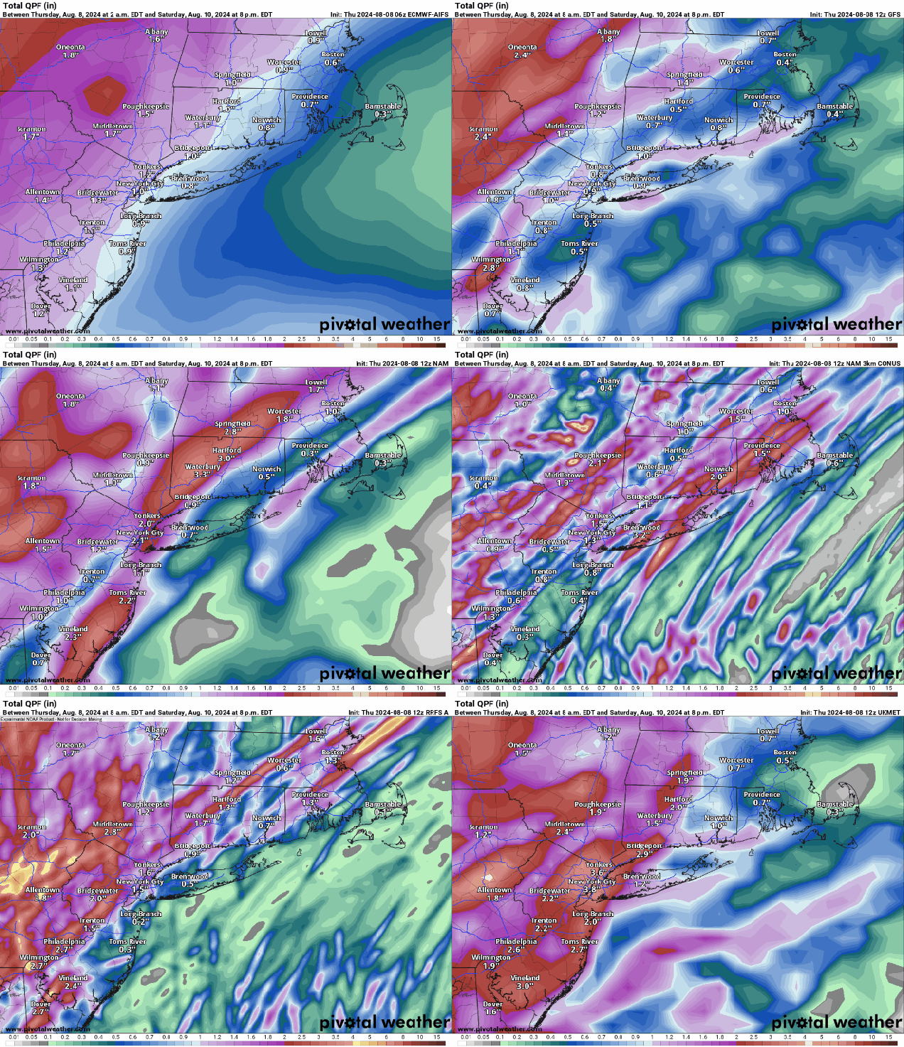
There may be some heavier downpours, but for the most part, the models do not bring heavy rain into the region for Friday. Images provided by Pivotal Weather.
Thursday night: Cloudy with a few showers likely. Low 60-67 during the evening, temperatures may rise a bit after midnight.
Friday: Mostly cloudy, some occasional showers at times, becoming breezy in the afternoon. High 77-84.
Friday night: Mostly cloudy, breezy, showers becoming more widespread with some heavier downpours and a few rumbles of thunder. Low 69-76.
Saturday: Breezy with showers and thunderstorms ending in the morning (early afternoon across Cape Cod), becoming partly to mostly sunny. High 81-88, a little cooler across Cape Cod.
Saturday night: Clear to partly cloudy. Low 58-65.
Sunday: Sunshine and a few clouds, not as humid. High 76-83.
A much cooler and wetter week is upcoming for the region.
Some models show the potential for a significant amount of rain Tuesday and Wednesday. Images provided by Pivotal Weather.
We’ve got one more hot and humid day today with high pressure offshore, but big changes are on the way. A cold front will move in tonight, possibly accompanied by some showers and thunderstorms. The front is expected to stall out near or just south of us on Tuesday, with much cooler weather likely behind it. Some additional showers are likely during the day on Tuesday. A wave of low pressure riding along the front will bring in some rain for Tuesday night and Wednesday, possibly some heavy rain, especially south of the Mass Pike. Despite how wet it has been around here for the past year or more, we’ve actually been rather dry for the past month or two, and can use the rain, though maybe not all at once. High pressure briefly brings in drier air for Wednesday night and part of Thursday before Debby impacts the region.
By Friday evening, there is a more than 1000 mile spread in the Ensemble members for the location of Debby. Image provided by Tomer Burg.
As of 2am, Hurricane Debby was centered only 40 miles west of Cedar Key, Florida, moving toward the north at 12 mph. Maximum sustained winds were near 80 mph. By the time most of you read this, Debby will have already made landfall in the Florida Big Bend region. Storm surge flooding will gradually die down this morning, and winds will steadily weaken, but rain will continue across the Southeast for several days, with widespread significant flooding likely from northern Florida into the Carolinas. Once inland, Debby is likely to stall out as steering currents collapse, and meander around in the Southeast, resulting in all of that rainfall. While Debby is doing that, some of the moisture from it will get drawn northward, interacting with that stalled frontal system, bringing us some rain for Friday and Saturday. In fact, we could be looking at quite a bit of rain. The wildcard is Debby itself. Some models have Debby dissipate across the Southeast, some bring it back offshore then into the Carolinas before heading up the coast in a weakened state, and some keep it inland and weak, then bring it up here. If it gets up here, there is even more uncertainty, as some models bring what’s left of the circulation right across southern New England, some bring it south of New England, while strengthening as it becomes extratropical, which introduces even more issues here, including gusty winds, not to mention temperature forecasts depending on the where the storm tracks. What you see below is our “best guest-imate” right now, but obviously this is very low confidence based on everything we just mentioned. A cold front will move through Saturday night, kicking whatever is left of Debby out to sea, and bringing drier weather in for Sunday.
Depending on Debby’s track, parts of the region could receive more heavy rain Friday and Saturday. Images provided by Pivotal Weather.
Monday: Mostly sunny, clouds start to increase late in the day. High 85-92, little cooler across Cape Cod.
Monday night: Partly to mostly cloudy with showers likely. Low 65-72.
Tuesday: More clouds than sun, any showers end early, possibly redevelop towards evening. High 72-79, early, cooler in the afternoon.
After a nearly month-long slumber, the Atlantic is waking up again with the formation of Tropical Storm Debby.
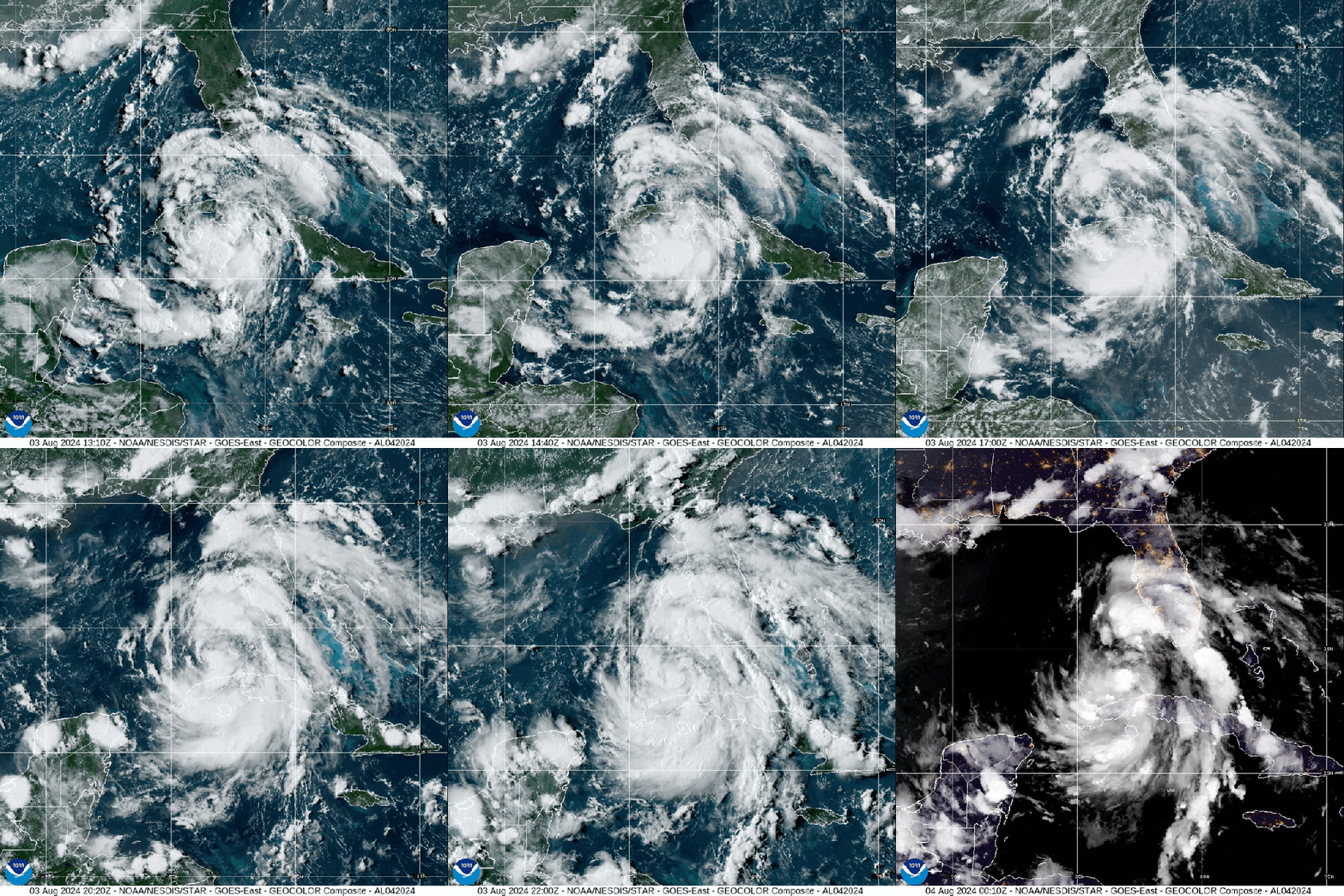
Satellite loop of Tropical Storm Debby. Loop provided by NOAA.
A tropical wave that we’ve been watching for nearly a week finally found some favorable atmospheric conditions as it moved into the eastern Gulf of Mexico, and became Tropical Depression Four Friday night, then was upgraded to Tropical Storm Debby Saturday afternoon. As of 8pm Saturday, Debby was centered about 100 miles west-southwest of Key West, Florida, moving toward the northwest at 14 mph. Maximum sustained winds were near 40 mph. Most of the west coast of Florida and the Florida Panhandle are under a variety of Tropical Storm, Hurricane, and Storm Surge Watches or warnings.
Forecast track for Tropical Storm Debby. Image provided by the National Hurricane Center.
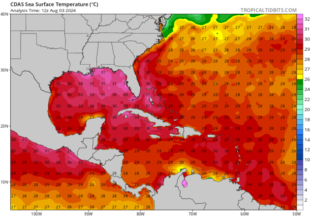
Debby’s immediate future is fairly simple – it will turn more toward the north while strengthening over the next day or so, heading towards the Florida Panhandle or the Big Bend area. The official forecast from the National Hurricane Center calls for Debby to reach minimal hurricane strength before making landfall early Monday. However, the models (and NHC) do a poor job forecasting rapid intensification, and the water in the eastern Gulf of Mexico is extremely warm, providing plenty of fuel for the storm. While the forecast doesn’t show it, we wouldn’t be surprised if Debby does intensify rapidly at some point on Sunday, and is a much stronger storm at landfall.
Water temperatures in the eastern Gulf of Mexico are 30-32C (85-90F). Image provided by Tropical Tidbits.
Once inland, the steering currents collapse, and Debby will slow down and meander around across parts of northern Florida, Georgia, or South Carolina during the first part of next week while weakening. This will increase the flooding threat across the region (more on that in a bit). After that, things get very uncertain. Some models keep the storm inland over the Southeast, steadily weakening before heading northeastward later in the week. Other models bring the storm back out into the Atlantic, with some strengthening, with a second landfall in the Carolinas, or a turn out to sea. At this point, it’s impossible to tell which scenario will happen, so we won’t even attempt to.
The various model ensembles show a wide range of potential tracks for Debby over the next 5 days. Loop provided by Tomer Burg.
Debby will have significant impacts across Florida and parts of the Southeast over the next few days. Strong winds are obviously a threat near where the storm makes landfall. Storm surge is likely across most of the Florida Gulf Coast, with the highest surge and correspondingly highest chance for coastal flooding near and to the right of where the storm makes landfall. By far, the biggest threat is freshwater flooding from heavy rainfall. Widespread rainfall totals of 5-10 inches are expected from central Florida into southern North Carolina, with heavier amounts likely, especially if the storm does stall out. Rainfall totals in excess of 20 inches are not out of the question, especially in parts of Georgia and South Carolina.
Extreme rainfall is likely across the Southeast from Debby with widespread flooding likely. Image provided by Weathermodels.com
While there are no other storms on the horizon at this time, we are getting closer to the peak of hurricane season, so it is likely just a matter of time until the next storm develops.
Unsettled weather returns this week, but that doesn’t mean any of the days will be a washout.
Showers should taper off this morning, but a few are still possible through the evening. Loop provided by WeatherBell.
A weak low pressure system will pull away from the region today, with any lingering showers coming to an end, and some sunny breaks developing. We could see a few more showers and thunderstorms pop up during the afternoon, but they’ll likely be few and far between. After that, the Bermuda High sets up shop offshore once again, with humidity levels increasing, and temperatures following suit later in the week. We’ll have a series of weak upper-level disturbances also scooting across the Northeast, and these will help to trigger some pop-up showers and thunderstorms each afternoon right through the week. Once of these disturbances may be a little stronger than the others when it moves through on Wednesday, which could lead to some stronger storms, with heavy downpours and strong winds possible in some of them. By the end of the week, temperatures may top 90 again in some areas, accompanied by high humidity, resulting in heat indices well into the 90s or even higher.
Temperatures could top 90 later this week. Image provided by Weathermodels.com
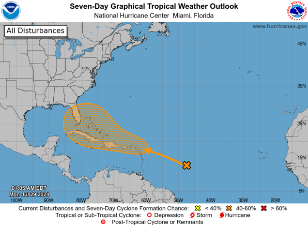
Just a quick note about the tropics as well. After Beryl made landfall in Texas, it’s been rather quiet for a few weeks, but that may be changing. A tropical wave crossing the Atlantic may interact with another disturbance as it approaches the Lesser Antilles. There is some potential for this system to develop into a tropical depression later this week. One of the forecast models has been rather insistent on the development of this system, and not only that, it tries to make it a threat to the East Coast. This is just one model, and most of the others do not show this scenario. Of course, this hasn’t stopped the Facebook Forecasters from cranking up the hype machine already. The odds that this system will be a threat up here are extremely tiny at this point in time. We won’t say they are zero, but for now, it’s roughly the same odds that the USA Basketball team doesn’t win a medal at the Olympics. Still, it’s looking like the next couple of months will be rather active, and we are extremely overdue for a hurricane to come calling, so we’ll be keeping a close eye on things for you and will let you know if there is a storm we actually need to be concerned about.
After a 3-week slumber, the Atlantic could be waking up again. Image provided by the National Hurricane Center.
Monday: Plenty of clouds with showers early, some afternoon sunny breaks with another shower or thunderstorm possible, humid. High 71-78.
Monday night: Any lingering showers end in the evening, otherwise partly cloudy, areas of patchy fog may develop. Low 62-69.
Tuesday: Partly sunny, slight chance for an afternoon shower or thunderstorm. High 81-88.
Tuesday night: Partly to mostly cloudy. Low 66-73.
Wednesday: Intervals of clouds and sunshine with scattered showers and thunderstorms, a few could produce heavy downpours and gusty winds. High 76-83.
Thursday: A mix of sun and clouds, chance for a pop-up shower or thunderstorm. High 82-89.
Friday: Partly sunny, some late-day showers or thunderstorms are possible. High 84-91.
Saturday: Partly sunny, chance for a shower or thunderstorm. High 84-91.
Sunday: A mix of sun and clouds, slight chance for a shower or thunderstorm. High 83-90.
The long weekend will feature typical summertime weather – warm temperatures, moderate to high humidity, and a daily chance for pop-up showers and thunderstorms.
Dewpoints will get well into the 70s around here on Saturday. Image provided by WeatherBell.
After a couple of warm but dry days, we’ll see humidity levels increasing over the next few days thanks to southwest winds. A weak front will move in for the Fourth of July, but it won’t ruin any plans you may have. It will bring in some clouds, but only a few widely scattered showers and/or thunderstorms. So, keep an eye to the sky if you’ve got outdoor plans, but don’t go cancelling them, as most places will remain dry. Some patchy dense fog is likely Thursday night, especially near the South Coast, but it shouldn’t impact any fireworks displays. Friday looks like a typical summertime day with partly sunny skies, warm and humid conditions, and a few pop-up showers or thunderstorms. Another weak system moves in for Saturday, resulting in a very humid day, with a better chance for showers and thunderstorms, especially late in the day and at night. Sunday and Monday will be similar to Friday, with intervals of sun and clouds, fairly humid conditions (but not as humid as Saturday), and a few widely scattered showers and thunderstorms each afternoon.
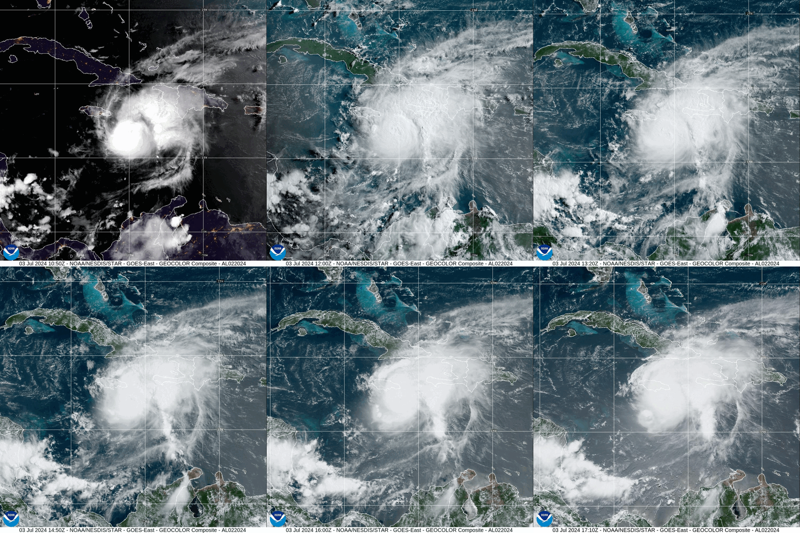
Hurricane Beryl is approaching the south coast of Jamaica this afternoon. Loop provided by NOAA.
Meanwhile, in the tropics, Hurricane Beryl is barreling towards Jamaica this afternoon. As of 2pm, Beryl was centered about 45 miles south of Kingston, Jamaica, moving toward the west-northwest at 18 mph. Maximum sustained winds were near 140 mph, making Beryl a Category 4 hurricane. It is the strongest storm to impact Jamaica since Hurricane Dean in 2007. Damaging winds, torrential rain, and flooding are likely across Jamaica for the rest of the afternoon and evening, especially southern portions of the island, then Beryl will head toward the Cayman Islands tonight. Beyond that, it will continue across the Caribbean while gradually weakening before another likely landfall in the Yucatan Peninsula early Friday. It should weaken over the Yucatan, but it will move back into the Gulf of Mexico late Friday, then could strengthen once again. The models are split on whether it continues westward into Mainland Mexico or makes it a right turn and heads for southern Texas, but we’ll worry about that later this week.
After Jamaica, Beryl will head towards the Cayman Islands and the Yucatan Peninsula. After that, things ger murky. Loop provided by Tomer Burg.
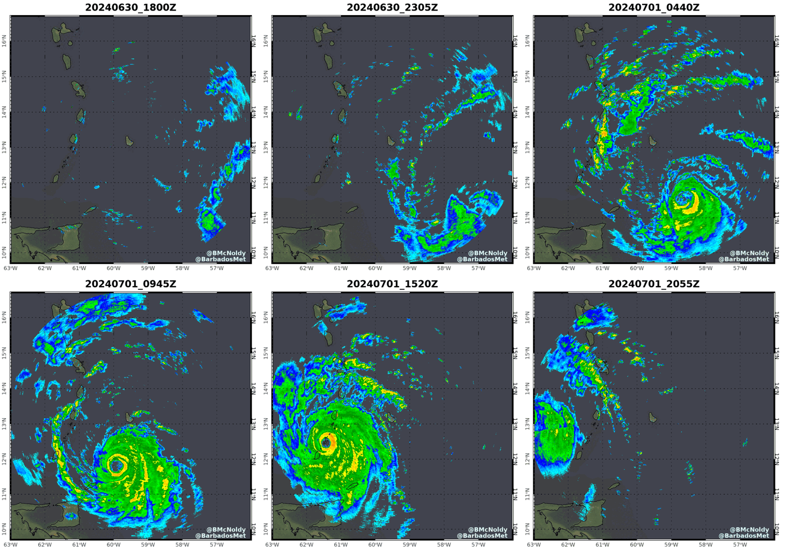
Beryl has been shattering records over the past several days even before crossing the Windward Islands. It is the strongest storm ever in the Atlantic during the months of June and July. It is the earliest Category 5 hurricane ever in the Atlantic (by more than 2 weeks). It was the strongest storm to ever cross the Southern Windward Islands when it moved across Carriacou Island on Monday with top winds near 140 mph. Sea surface temperatures are well above normal across the Atlantic and Caribbean, which aided in Beryl getting so strong, but it also featured upper-level conditions that were nearly ideal for development and strengthening, which is not that common during June and July.
Radar loop from Barbados showing Beryl’s approach and passage. Loop provided by Brian McNoldy/University of Miami.
Wednesday night: Partly cloudy. Low 59-66.
Thursday: Partly sunny, more humid, slight chance for a shower. High 80-87, a little cooler near the coast.
Thursday night: Partly to mostly cloudy with a few showers possible and some patchy fog developing. Low 63-70.
Friday: Partly sunny, slight chance for a shower or thunderstorm. High 83-90, a little cooler across Cape Cod.
Friday night: Mostly cloudy, chance for a few showers. Low 64-71.
Saturday: More clouds than sun, very humid, chance for a few showers or thunderstorms. High 77-84.
Saturday night: Partly to mostly cloudy with a few showers or thunderstorms. Low 66-73.
Sunday: A mix of sun and clouds. High 85-92, a little cooler across Cape Cod.
Sunday night: Partly cloudy. Low 63-70.
Monday: Intervals of sun and clouds. High 84-91, a little cooler across Cape Cod.