Despite what the app on your phone says, most of the weekend will actually be rather pleasant.

What’s left of Debby will head northward tonight, sending a warm front across the region. Some showers may accompany it, but you’ll notice humidity levels increasing once again. Temperatures may actually rise a few degrees overnight as winds shift into the southeast and south. Ex-Debby will pass well north and west of the region Friday and Friday night, keeping us in the warm and humid side ahead of the storm. We’ll have some occasional showers during the day on Friday, but it won’t be a washout. Some steadier and potentially heavier showers are likely Friday night into early Saturday as Ex-Debby crosses northern New England and drags a cold front across our area. The showers end Saturday morning, then we’ll clear out in the afternoon, with gusty west to northwest winds ushering drier air in, though it will remain quite warm. High pressure then builds in for Sunday and Monday with sunshine, warm temperatures, and comfortable humidity levels.
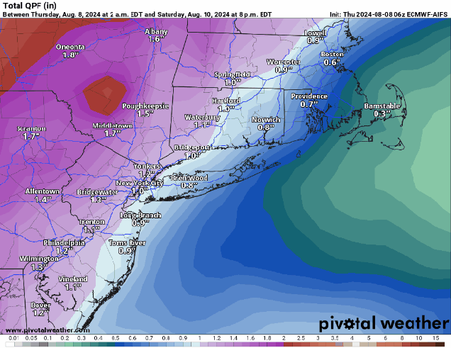
Thursday night: Cloudy with a few showers likely. Low 60-67 during the evening, temperatures may rise a bit after midnight.
Friday: Mostly cloudy, some occasional showers at times, becoming breezy in the afternoon. High 77-84.
Friday night: Mostly cloudy, breezy, showers becoming more widespread with some heavier downpours and a few rumbles of thunder. Low 69-76.
Saturday: Breezy with showers and thunderstorms ending in the morning (early afternoon across Cape Cod), becoming partly to mostly sunny. High 81-88, a little cooler across Cape Cod.
Saturday night: Clear to partly cloudy. Low 58-65.
Sunday: Sunshine and a few clouds, not as humid. High 76-83.
Sunday night: Clear skies. Low 58-65.
Monday: Mostly sunny. High 75-82.
