Wet Weather and High Humidity Are Coming

You know that dry weather we’ve had for much of the Spring and Summer? How about those warm days with low humidity? Well, both will be a distant memory by this time next week.

A weather pattern that is both typical and atypical of summer at the same time is going to settle into the nation over the next several days. The typical part is that we’ll have a ridge of high pressure off the East Coast, and another one in the Southwest. The ridge off the East Coast will result in heat and humidity up and down the coastline for the next several days. The ridge in the Southwest will bring very hot conditions to the Southwest and especially the Southern Plains, where record highs are expected over the next several days. The Atypical part is across the Midwest. Normally, in between the two ridges of high pressure you’d have a trough of low pressure, but in this case, we actually have a closed upper-level low pressure system. While these are common in the fall, winter, and spring, they usually don’t occur much in the summer. This will bring cooler than normal conditions into the Midwest for the next few days.

500wh.conus
What is this, April? The upper-level pattern features ridges of high pressure in the Southwest and off the East Coast, and an upper-level low pressure system in the Great Lakes. Image provided by Pivotal Weather.

With high pressure anchored off the East Coast, a warm and humid pattern will set up for much of next week (and possibly longer). Notice that we said “warm”, and not “hot”. While temperatures will still be a little above normal this weekend into much of next week, highs will only be in the 80s to lower 90s for most of the Eastern US. While the temperatures won’t be that bad, humidity levels will. With high pressure anchored off the East Coast, a southerly flow will help moisture stream northward from the tropics right up the East Coast this weekend and into much of next week. Dewpoints will be in the upper 60s and 70s across the region, so even though temperatures may not be hot, it will feel oppressive across much of the region.

GFS Pressure Lev East Coast USA Precipitable Water
Moisture will stream northward from the tropics into much of the East Coast over the next several days. Loop provided by WeatherModels.com


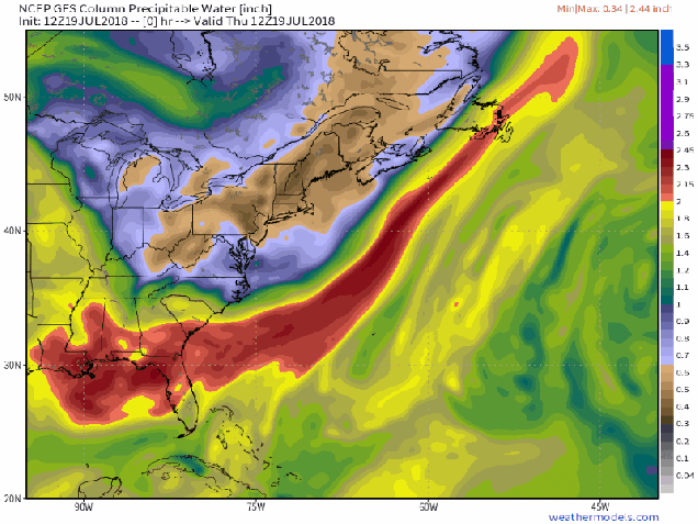
With a warm and humid airmass in place for much of the week, it won’t take much for showers and thunderstorms to develop each day. With plenty of available moisture, some of these storms will end up producing very heavy rainfall. While the map above is a forecast that shows widespread coverage of heavy rain, in many cases, the storms will be very localized. Some locations could get hit by slow-moving thunderstorms over and over, while other spots a few miles away get little to no rainfall. Across the Mid-Atlantic States, where heavy rain led to flooding during the Spring, similar conditions are possible again for the next week. Across the Northeast, things are a little different.

GFSMA_prec_precacc_204
That’s a lot of rain from the Carolinas northward over the next week or so. Image provided by College of DuPage.


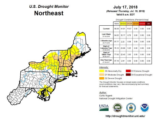
Here in New England, and in New York too, much of the Spring and early summer has been very dry. Localized thunderstorms have brought heavy rain to a few spots, especially earlier this week, but overall, rainfall has been well below normal across the area. Some relief will come this weekend. A weak low pressure system will move across the region late Saturday into Sunday as an upper-level low pressure system moves into the Midwest. The surface low will bring heavy rain and some gusty winds to parts of Southern New England and southeastern New York. The heaviest rain is expected late Saturday night into early Sunday morning, so neither day should be a complete washout. Once that system moves by, a warm and humid airmass will settle in, with a daily chance for showers and thunderstorms this week. Again, some places could get drenched, and some might get missed completely. Some could see off-and-on showers and storms for 6 hours, some could get a shower that lasts 6 minutes. Basically, it’ll be like living in Florida for a week, without having to worry about looking outside and finding an alligator in your swimming pool.

20180717_Northeast_trd
It’s been very dry across New England and New York for a few months now, with drought conditions developing. Image provided by the National Drought Monitor.


Think warm and humid conditions with a daily chance of thunderstorms isn’t fun? It could be worse. Normally, it’s hot across Texas and the Southwest during the summer. This week though, the ridge of high pressure that is currently setting up across the Southern Plains and Southwest will bring in temperatures that are well above normal. In fact, record highs are expected for the next several days across much of Texas, as temperatures soar past 100 across much of the state, with some locations possibly exceeding 110 degrees. Unlike when the models were forecasting those temperatures here a few weeks ago, this time it’s going to happen. The heat won’t be confined to the Lone Star State either, with triple-digit highs also expected from parts of the Lower Mississippi Valley into the Southern Plains as well as parts of Colorado and New Mexico. There won’t be much, if any, relief at night either, as low temperatures will stay in the 70s, with many locations, especially urban areas like the Dallas-Fort Worth Metroplex likely not dropping below 80 degrees for low temperatures.

ndfd_record_high_tx_2
Friday looks to be the hottest day across the Southern Plains and Texas, with many record highs expected to be broken. Image provided by WeatherModels.com


As we head into next week, the heat will ease a bit across Texas and the Southern Plains, but the core of the intense heat will shift westward into the Desert Southwest. High temperatures will top 110 degrees across much of the area for the first half of next week, with the usual hot spots such as Lake Havasu City, Arizona; Laughlin, Nevada; and Death Valley, California likely exceed 120 degrees during some of the afternoons. Highs will also top 100 across much of interior California once again. Anyone wanna place a bet as to whether Death Valley reaches 125? Better yet, will they have a night where the temperature doesn’t drop below 100 (it’s happened before)?

fema04_swody2
A severe weather outbreak is possible on Friday across the Ohio and Tennessee Valleys. Image provided by the Storm Prediction Center.

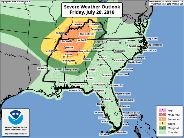
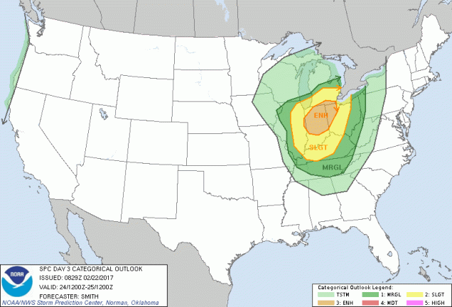
Meanwhile, an upper-level low pressure area will settle into the Midwest. With the clash in airmasses along a cold front, showers and thunderstorms will develop. Some of these storms will become strong to severe on Friday, especially across the Ohio and Tennessee Valleys. The main threats with any storms that develop will be strong winds, large hail, and torrential rainfall that could trigger flash flooding. Some tornadoes are also possible. The storms may start during the morning closer to the Great Lakes, with the afternoon and evening seeing the most widespread activity across the region. While activity should weaken at night, the threat of severe weather will continue across southern and eastern parts of the region.

NAM-WRF 3-km null Simulated Radar
Strong to severe thunderstorms are expected across the Midwest on Friday. Loop provided by WeatherModels.com


As these storms crossed the Midwest today, they produced wind gusts to 90 mph and more than 30 tornadoes across Iowa. The town of Marhsalltown was devastated by a tornado earlier today. How bad was it? We’ll end this post with the Storm Report from the National Weather Service Office in Des Moines with the description of what happened in Marshalltown:


REPORTS OF CATASTROPHIC DAMAGE, INCLUDING 
VEHICLES MISSING, VEHICLES OVERTURNED, TOPS
OF BUILDINGS GONE, TREES DOWN, POWER LINES,
GAS LINES, ETC...

An Active Afternoon Ahead

No, we’re not expecting anything like that across the region this afternoon, but if you’ve got outdoor plans, you may want to keep an eye to the sky – we’ve got thunderstorms coming, and some of them could be strong to severe.

SNE
It’s a little humid for mid-May, but temperatures in the 70s to lower 80s at midday are pretty nice. Image provided by NOAA.

We’ve got a rather nice day in progress across the region, but changes are coming. At midday, temperatures are generally in the 70s to lower 80s away from the coastline, where seabreezes are keeping temperatures in the 50s to lower 60s. Dewpoints are creeping up, generally in the 60s now, which is humid by mid-May standards. We’ve also got plenty of sunshine, so temperatures should continue to climb into the afternoon. However, a cold front is starting to approach from the west. An area of showers and thunderstorms is moving into western Massachusetts at midday, and though these should weaken, they will spread cloud cover in, with some rain possible across northern Massachusetts and southern New Hampshire early this afternoon.

HRRR
The HRRR simulates what the radar should look like as we head through the afternoon and evening. Loop provided by WeatherModels.com

As that cold front approaches, a stronger line of thunderstorms is expected ahead of it. As you can see in the radar simulation above, this line should enter our region during the 5-8pm time frame, also known as the evening rush hour. Some of these storms will contain strong winds, heavy downpours, and frequent lightning. That will likely make the commute home for many people even worse than normal.

BOX_swody1 (1)
There is a moderate risk of severe weather across much of interior Southern New England this afternoon. Image provided by the Storm Prediction Center.

If it were just rain, wind, and lightning, it wouldn’t be a big deal. The problem is, it might be more than “just rain wind, and lightning.” Well away from the coastline, conditions will be favorable for severe thunderstorms to develop ahead of the front. As we mentioned in our Weekly Outlook, we still think the best odds for severe weather are from the Mid-Atlantic states into southeastern New York and western New England, but some severe storms could survive into eastern New England late this afternoon and evening. These storms should start to weaken quickly as they approach the coastal plain, but from interior Rhode Island into Central Massachusetts, the I-495 Belt of eastern Massachusetts, and Southern New Hampshire, we could see some fairly strong thunderstorms. We’ve already mentioned the frequent lightning and heavy downpours, but in the places we just mentioned, winds could gust to 60 mph or more with some of the stronger storms, which could result in more damage to places that already had lots of tree damage earlier this month.

Tornado
There is a low chance for a tornado or two this afternoon with some of the stronger storms. Image provided by the National Weather Service.

In addition to the threats we listed in the last paragraph, there is also a low (but non-zero) threat for am isolated tornado or two this afternoon. No, we’re not expecting a tornado outbreak, but a brief tornado or two could spin up, especially across central and western portions of New England. In fact, if we do get one, it wouldn’t even be the first one this year in New England. Just last night, we found out that on May 4, a tornado tracked 35 miles through mostly (but not all) rural western and central New Hampshire.

GFS 50-STATES USA Mass & CT & RI 2-m Maximum Temperature 36
Temperatures on Wednesday will be 20-30 degrees cooler than today. Image provided by WeatherModels.com

Behind the front, Wednesday will be a much cooler day. Easterly winds and some cloud cover will keep temperatures in the 50s along the coast, lower 60s inland. Sunshine and warmer temperatures will return on Thursday, so you’ll only have one day to complain about.

Weekly Outlook: August 21-27, 2016

As we start a new week all eyes will literally be looking at the sky. As you may have heard, there’s an eclipse today. The weather will cooperate, as high pressure provides us with sunshine, so viewing it shouldn’t be a problem. You’ve probably also heard plenty of people warning you not to look directly at the sun during the eclipse. Since you’ve heard it enough already, we won’t say it. Besides, if you want to look at the sun, we won’t stop you. Eyesight is overrated anyways. Plenty of people live without it. If that’s what you want, who are we to stop you? You’ll still be alive and free to go golfing in the middle of the thunderstorms we’re expecting on Tuesday. Don’t worry, they’ll likely be coming at night, so even if you were golfing, you wouldn’t be able to find the ball if you had eyesight.

hrrr_cloud_boston_16
Cloud cover forecast from the HRRR model for 2pm Monday. Just a few clouds around, which shouldn’t impact eclipse viewing much. Image provided by WeatherBell.


Now that we’ve given you the teaser and the sarcasm, let’s get to the details. We start the week off with high pressure, giving us a fantastic Monday. A cold front approaches on Tuesday, producing showers and thunderstorms, mainly at night. A few of these storms could be quite strong, but with the activity mostly expected at night, that should limit the potential for severe weather. Of course, that doesn’t mean you should let your guard down. These storms still could produce heavy downpours, but severe weather is still possible at night. In fact, Tuesday marks the one year anniversary of the tornado that impacted Concord, MA at 3:20 in the morning.

14107865_1077824382311932_2028629579549064186_o
A rare overnight tornado impacted Concord, MA one year ago tomorrow. Image provided by the National Weather Service office in Taunton, MA.

The showers and thunderstorms will taper off and end early Wednesday as a cold front crosses the region, then things get quiet again. We’ll dry out Wednesday afternoon but it will remain warm. We’ll cool off a little more on Thursday as an upper-level trough of low pressure settles into the Northeast while high pressure does at the surface, which will result in some cool days for Friday and the weekend.

Monday: Sunshine and a few afternoon clouds, dimmed for a while by a passing moon in the afternoon. High 82-89.

Monday night: High clouds overspread the region. Low 64-71.

Tuesday: Clouds thicken up, with some showers and thunderstorms possible late in the day. High 85-92.

Tuesday night: Showers and thunderstorms likely, some of which could contain heavy downpours and gusty winds. Low 68-75.

Wednesday: Showers and thunderstorms end in the morning, then skies clear out in the afternoon. High 78-85.

Thursday: Sunshine and some afternoon clouds. High 74-81.

Friday: A sunny start, then clouds start to pop up with a slight chance for a spot shower in the afternoon. High 71-78.

Saturday: A mix of sunshine and clouds. High 70-77.

Sunday: Partly to mostly sunny. High 70-77.

Finally, we get to a topic that doesn’t impact this week’s forecast, but could have an impact early next week. For several days now, the Canadian model has been extremely insistent on a tropical disturbance developing near the Bahamas and eventually moving northward, up the East Coast early next week. There have been a few reasons to ignore this for the past few days:

  1. This was the only model showing this feature.
  2. The Canadian model always seems to take every little ripple in the tropics and blow it up into a hurricane.

So, why are we mentioning it now? There are a few reasons.

  1. Other models are starting to show the potential for something to develop near the Bahamas or Florida late this week or early next week.
  2. The Canadian model has been slightly better than many of the other models in regards to the tropics so far this season.
  3. It’s had this feature with very little variation for at least 6 consecutive model runs.

That last point is the main reason why we at least feel the need to mention it. This model has not really wavered much at all, and consistency is one of the things we look for in a model before we start to trust its solution. Add in the fact that other models are starting to come around, and well, it’s something we need to keep an eye on. This does not mean that a massive hurricane is going to wipe out the East Coast just before Labor Day. If anything does materialize, we’ll obviously keep you informed, but for now, it’s just something to keep in the back of your mind. (Of course, now that we’ve mentioned it, the next run of the Canadian model will likely change its tune completely)

gem_mslp_wind_92L_fh0-240
Forecast for Atlantic Disturbance 92L based on the Canadian GEM model initialized Sunday evening. Loop provided by Tropical Tidbits.

Weekly Outlook: July 3-9, 2017

HoustonKansasCity 138
We’ll have perfect weather for fireworks displays on the Fourth of July.

We’ve made it to July, and the stubborn pattern we had for much of the Spring and well into June is finally gone.

We’ll start right off with the forecast for Tuesday, since that’s the day people are most interested in. Planning a barbecue? Perfect weather for it. Heading into the pool or to the beach? Bring the sunscreen. Watching fireworks in the evening? No problems expected. Stuck working because your chosen profession doesn’t take holidays? Sucks to be you, but don’t expect anyone to feel bad for you.

As for the rest of the week, sunshine and warm temperatures will be here for the next few days, along with low humidity, as high pressure builds in across northern New England. There is a slight chance for a shower or thunderstorm this afternoon as a weak upper-level disturbance moves through, mainly along the South Coast. However, the bulk of the activity looks like it should remain well to our south and west. As the high slides offshore later this week, humidity will start to creep back into the region. With humidity comes the risk for afternoon showers and thunderstorms. That risk looks to be the greatest Friday and Saturday as another cold front starts to approach the region. While it’s still a bit early, and the timing of the front will play a critical role, we wouldn’t be surprised to see some severe storms develop on Saturday, if everything comes together. We’ll monitor this as the week progresses. High pressure will build in behind the front with drier conditions for next Sunday.

GFSNE_con_sbcape_141
A moist and unstable airmass may be in place ahead of a cold front next Saturday, which could help to produce strong to severe thunderstorms. Image provided by the College of Dupage.
GFSNE_sfc_dewp_141
A moist and unstable airmass may be in place ahead of a cold front next Saturday, which could help to produce strong to severe thunderstorms. Image provided by the College of Dupage.

While we’ve got a fairly simple forecast here for most of the week, things are starting to cook out in the Atlantic. A tropical disturbance located well east of the Lesser Antilles has the potential to develop into a tropical depression later this week.  There’s nothing to worry about now, but some of the models (not all), try to develop the system into a hurricane at some point, and possibly become a threat to the East Coast or Bermuda about 2 weeks from now. The odds of this happening are still pretty low, so we wouldn’t worry about it too much, but we’ll certainly keep our eyes on this system, as well as the rest of the tropics.

94L_gefs_latest
GFS Ensemble forecasts for the track of a tropical disturbance in the Central Atlantic. Image provided by Tropical Tidbits.


Monday: A mix of sun and clouds, just a slight chance for an afternoon shower or thunderstorm near the South Coast. High 81-88.

Monday night: Clear to partly cloudy. Low 58-65.

Tuesday: Sunshine and a few clouds. High 77-84.

Tuesday night: Clear skies. Perfect weather for fireworks in the evening. Low 55-62.

Wednesday: Mostly sunny. High 78-85.

Thursday: A sunny start, then clouds develop along with the chance for some afternoon showers and thunderstorms, becoming humid. High 77-84.

Friday: A mix of sun and clouds, humid, chance for some afternoon showers and thunderstorms. High 80-87.

Saturday: Partly sunny, more showers and thunderstorms are possible. Some of the storms could be strong to severe in the afternoon. High 83-90.

Sunday: Mostly sunny with a few afternoon clouds, drier. High 75-82.

Summer Arrives (in the East)! Winter’s Back (in the Rockies)!

The current weather pattern across the country is one that is fairly typical of Spring. However, the results of that pattern are Winter in the Rockies and Summer in the East. In between, there is plenty of severe weather, which is fairly typical of Spring.

US500.20170517.12
A ridge in the East, a trough in the West. Not that uncommon of a pattern. Image provided by College of DuPage.

An upper-level low pressure area will move out of the Pacific Northwest and into the nation’s midsection over the next few days. While one storm system moves into the Upper Midwest today, a second one will develop east of the Rockies and move into the Plains states on Thursday. With cold air moving in behind these systems, and warm, moist air flowing northward from the Gulf of Mexico ahead of them, strong to severe thunderstorms are likely again for the next few days across the Plains states.

day2otlk_1730
Thursday could be a very active day for severe weather in the Central and Southern Plains. Image provided by the Storm Prediction Center.

Severe weather has plagued the Plains states and Great Lakes for the past few days, with over 500 reports of severe weather between Monday and Tuesday. Nearly 30 tornadoes were reported, along with hail as large as softballs, and hundreds of reports of wind damage from gusts as high as 85 mph.


Behind the low pressure area, a late-season snowstorm is expected across the Rocky Mountains. Heavy snow will continue across portions of Montana and Idaho today, spreading into Wyoming and Colorado for Thursday into Friday. Across the higher elevations, totals of 1-3 feet are expected, which will keep the ski season going for a while longer. Snow may also spread into the High Plains of eastern Colorado and western Nebraska, with some minor accumulations possible. In Denver, it looks a couple of slushy inches may fall, though at least 1 model is forecasting much heavier amounts. In a normal year, Denver averages 1.7″ of snow, and the city has seen measurable snow during the month of May in 11 out of the last 16 years, so snow in May is not uncommon, though a heavy snowstorm, if it materializes, would be. Denver has only received 10 or more inches of snow in the month of May 6 times in a 135 years of records, with a record total of 15.5″ set back in May of 1898.

gfs_6hr_snow_acc_cw_13
A late-season snowstorm may drop up to 3 feet of snow in the higher elevations of the Rockies. Image provided by WeatherBell.

Meanwhile, in the East, an early taste of summer is ongoing, thanks to a ridge of high pressure aloft, and a surface high pressure area off the East Coast. Temperatures soared into the 80s and lower 90s on Wednesday, setting several records, but the hottest day for many locations will be Thursday. High temperatures will climb into the lower to middle 90s in many locations, likely breaking records across much of the region. When you combine the heat with dewpoints well into the 60s, it will definitely feel like a mid-summer afternoon across the region. A cold front will move through the area of Friday, possibly triggering a few showers and thunderstorms, but also sending temperatures back to where they should be in the middle of May.

ndfd_record_hi_neng_2
A lot of record high temperatures may be broken across the Northeast on Thursday. Image provided by WeatherBell.

Severe Weather in the South Today, but a Bigger Threat Looms for Friday

Severe weather is likely across portions of the Gulf Coast and Mississippi Valley today, but another, perhaps more widespread, outbreak is possible at the end of the week. While that is happening, a snowstorm might also be brewing in the Rockies. Spring can feature a little bit of everything across the nation.

fema06_swody1
Severe weather is expected across portions of the Mississippi Valley today. Image provided by NOAA.

A strong cold front is moving into the Mississippi Valley and Texas this afternoon, and it is helping to trigger strong to severe thunderstorms across portions of the region. Ahead of the front, temperatures are into the 70s and lower 80s, with dewpoints in the upper 60s and 70s, so there’s plenty of warm, moist air in place. Behind the front, temperatures quickly drop into the 40s and 50s. Thunderstorms will continue to develop in the unstable airmass ahead of the front, with some of the storms containing large hail, heavy downpours, damaging winds, and possibly some tornadoes. Earlier this morning, some storms produced baseball-sized hail and wind gusts in excess of 70 mph in portions of Missouri, Arkansas, and Oklahoma. The threat should start to diminish across the region as we head into the overnight hours.


A more significant severe weather outbreak is possible later Friday into Saturday from the Southern Plains and Texas into portions of the Mississippi and Tennessee Valleys. Low pressure will move out of Texas and head northeastward, drawing warm, moist air northward from the Gulf of Mexico once again. North and west of the system, much cooler air will be in place (more on that in a moment).

sbli.us_sc
Lifted index values of -10 and lower across Texas and the Lower Mississippi Valley show that the airmass will be very unstable on Friday. Image provided by Pivotal Weather.
sbcape.us_sc
CAPE values of 4000 J/kg and higher across Texas and the Lower Mississippi Valley show that the airmass will be very unstable on Friday. Image provided by Pivotal Weather.

As low pressure rides along the boundary between the two airmasses, it will help to trigger strong to severe thunderstorms across the region. The threat will continue into the overnight hours Friday night, shifting into the Mississippi and Tennessee Valleys on Saturday as the system continues to progress northeastward. Some of the storms may produce torrential downpours that could trigger flash flooding, large hail, damaging winds, and tornadoes.

gfs_tprecip_mc_21
The GFS model shows the potential for 5-10 inches of rain (or more) in parts of the Mississippi Valley through Sunday. Flooding is likely. Image provided by WeatherBell.

Behind the storm, as colder air settles into the region, a different threat is evolving – heavy snow. While it’s getting late in the season, heavy snow is not uncommon in the Central and Southern Rockies at this time of year. Some of the higher elevations in Colorado and New Mexico could receive 1-2 feet of snow Friday into Saturday. East of the Continental Divide, especially in the High Plains, snow is also possible, especially from eastern Colorado and western Kansas into portions of the Oklahoma and Texas Panhandles. In Denver, there is still a big question as to whether to precipitation falls mainly as rain, snow, or a wintry mix. Some snow accumulation seems likely at this point, but it’s still a little too early to tell whether there will be heavy snow in the city itself. The heavy snow threat will expand into the portions of the Upper Midwest and southern Canada Sunday into Monday as the storm moves into that region.

gfs_6hr_snow_acc_mc_21
GFS model forecast for snowfall in the Rockies and High Plains through Sunday. Winter is definitely not over there. Image provided by WeatherBell.

Severe weather outbreaks are not uncommon at this time of year. In fact, from late March into early May is when they are most likely. The largest tornado outbreak on record occurred 6 years ago this week. Between April 25 and 28, 2011, a total of 362 tornadoes were observed from Texas to New York and portions of southern Canada, resulting in 324 fatalities, 317 of them on April 27, the most active day.

149638-004-5B45E68E
Map showing tracks of all 362 tornadoes from the April 2011 “Super Outbreak”. Image provided by Encyclopedia Brittanica.

As for our part of the country – the clouds and rain and cool temperatures will eventually move out. Things will start to improve on Thursday with some sunny breaks possible and temperatures into the 60s. By Friday, there will be more sunshine and temperatures getting into the 70s. Saturday looks like the best day, as temperatures could get into the lower 80s in some spots. We will have to watch out for some late-day showers and maybe a thunderstorm. Sunday looks to be significantly cooler thanks to a northeast wind off of the still-chilly Atlantic.

In Like a Lion…

The old saying is that March comes in like a lion and goes out like a lamb. We’ll see about how it goes out, but it certainly looks like it’s going to come in like a lion this year, but not in the usual way.

We’ve got some unseasonably mild air already in place, but it’s going to get even warmer as a warm front moves across the region tonight. It’ll be accompanied by some showers, and maybe even a rumble of thunder when it moves through. Some of the rain overnight may be locally heavy, but since most of you will be sleeping when it comes through, you won’t even notice. Also, with the warm front coming through, we’ll have our low temperatures this evening instead of in the morning, as temperatures will slowly rise overnight.

ndfd_record_hi_neng_2
Plenty of record highs are expected across the Northeast on Wednesday. Image provided by WeatherBell.


This brings us to Wednesday. Once that warm front moves across the area, even warmer air will flood into the region, with highs again soaring well into the 60s. The only limiting factor for tomorrow will be cloud cover, which there will likely be plenty of. If we can get some breaks of sunshine, it wouldn’t be a surprise if temperatures made a run at 70 in spots.

Warm temperatures aren’t the only story for Wednesday though. A strong cold front will be approaching from the west. While this front will bring an end to our warmth Thursday morning, it’s what happens ahead of it that is a bigger concern.

ma_swody2
A slight risk for severe weather exists across parts of southwestern New England on Wednesday, with a marginal risk for most of the remainder of Southern New England. Image provided by the Storm Prediction Center.


As is usually the case during the warmer months, with a warm and relatively humid airmass in place, the atmosphere will become unstable. Add in some lift ahead of the front and you get showers and thunderstorms. The bigger the clash in airmasses, but stronger the storms. That’s what will happen tomorrow. Thunderstorms will develop ahead of the front during the afternoon and evening hours and may even continue into the nighttime ahead of the front. Some of the storms could become quite strong, with heavy downpours, frequent lightning, and damaging winds. There is even the chance for an isolated tornado. Just last week, a tornado touched down in Goshen and Conway, Massachusetts – the first confirmed tornado ever during the month of February in the Commonwealth.


New England isn’t the only place where severe weather is expected though. In fact, what’s expected up here is minor compared to the Ohio and Mississippi Valleys. As that cold front moves into those areas later today into early Wednesday, widespread severe weather is expected to develop. Large hail, heavy downpours, damaging winds and several tornadoes are expected. This is more typical of April than the last day of February.

After this front moves offshore, things quiet down a bit, and we get back into weather that is more typical of early March, especially here in the Northeast. We do need to keep an eye on Friday though. An Alberta Clipper will be diving southeastward from the Great Lakes. It will pass south of New England during the day on Friday and into Friday morning. While the majority of the forecast models keep the system far enough south of have little to no impact on us, not all of them do. So, there is the chance for some light snow, especially south of the Mass Pike, on Friday. We’ll have more on this later in the week if the threat materializes.

Record Highs, Blizzard Conditions, and Severe Weather – February in the Nation’s Midsection

“In the Spring, I have counted 136 different kinds of weather inside of 24 hours.” – Mark Twain

It’s not quite spring yet, but this quote is still appropriate. Much of the nation’s midsection has been enjoying temperatures more typical of April than February for the past week, with a few hundred record high temperatures broken. That is about to change, as Mother Nature will remind the region that is still February.

ndfd_record_hi_mc_1
Numerous record highs are expected across the Plains and Midwest again today. Image provided by WeatherBell.

Of course, they will still have one more warm day today, with highs well into the 60s and 70s likely setting more records. However, a cold front will sweep across the region, bringing an end to the record heat, and setting the stage for a snowstorm.

The low pressure system that brought more rain to California over the past couple of days will head eastward, bringing some snow into the Rockies today. As that system moves into the Plains on Thursday it will start to strengthen, drawing moisture northward from the Gulf of Mexico while cold air flows southward on the backside of the storm into the Northern Plains. Where these airmasses meet, snow will develop across the Central Plains states. The snow will be accompanied by winds of 20-30 mph, gusting to 40 mph or more at times, resulting in near-blizzard conditions across portions of South Dakota, Nebraska, southeastern Wyoming, and eastern Colorado on Thursday.

snku_acc-us_nc
More than a foot of snow may fall in a swath from the Plains into the Upper Midwest. A lot of these same places are going to be in the 60s and 70s today. Image provided by Pivotal Weather.

As the system heads eastward, snow will move into portions of the Mississippi Valley and the Upper Midwest on Friday. The heaviest snow looks to stay just south of the Twin Cities, but even there, moderate to heavy snow is likely. By the time the storm moves out on Saturday, a foot or more of snow is possible in a swath from the Central Plains into the Great Lakes.

Snow isn’t the only threat from this system. As the storm moves eastward, record warmth will remain in place across the Midwest. With warm, moist air in place and a strong cold front approaching from the West, strong to severe thunderstorms are possible across portions of the Lower Great Lakes and Ohio Valley on Friday. Some of the stronger storms that form may contain damaging winds, hail, and possibly tornadoes.

day3otlk_0830
The Storm Prediction Center has already highlighted the Midwest as an area to watch for severe weather on Friday. Image provided by NOAA.

The system will continue to move eastward, bringing some rain to the East Coast on Saturday, which may cause problems for hockey fans in the Steel City. The next NHL Stadium Series game (Ed – Enough with the outdoor games already. It jumped the shark a long time ago), is scheduled for Saturday at 8pm between the Pittsburgh Penguins and Philadelphia Flyers. The daytime hours will likely be mild with rain, but the rain may change to snow late in the day as temperatures tumble. Either way, it won’t be a pleasant night for fans to be sitting in the stands at Heinz Field. Here at Storm HQ, we despise the Flyers, so we hope their fans not only have to sit through the weather, but watch their team get thumped too.

scott-wilson-jpg-size-custom-crop-819x650
That’s former UMass-Lowell RiverHawk (and StormHQ favorite) Scott Wilson hoisting the Stanley Cup last June. Image provided by Toronto Star.

Once it gets past Pittsburgh, that front will head eastward, bringing some rain to us here in New England. It probably won’t be a lot of rain, but temperatures will be in the 50s and possibly 60s ahead of the front on Saturday. Once the front comes through, Sunday will be windy and colder.

After 2 Days of Severe Weather, The East Will Be Quiet This Weekend

Severe weather has been widespread across the eastern half of the nation for the past 2 days, but high pressure will bring much quieter conditions this weekend.

A cold front has been slowly dropping southward over the past 2 days, replacing warm and humid air with cooler and drier conditions. Ahead of the front, strong to severe thunderstorms have cut a large swath of damage.

yesterday_filtered
Reports of severe weather from Thursday June 16. Image provided by the Storm Prediction Center.

On Thursday, severe weather was widespread across the Mid-Atlantic states from mid-afternoon through the late evening hours. There were over 250 reports of damage from wind gusts as high as 77 mph, with a majority of the reports concentrated in West Virginia, Virginia, and Maryland, including the Washington, DC metropolitan area, where thunderstorms dropped 2.58″ of rain in just a couple of hours at Dulles Airport. In addition to the wind damage and heavy rain, hail as large as baseballs was observed with some of the strong storms. One tornado was also confirmed in Barnes Gap, Pennsylvania.

While most of activity quieted down in the evening, thunderstorms flared up across North Dakota and Minnesota. A cluster of storms moved across the state early in the morning, producing baseball-sized hail near Bismarck. Wind gusts as high as 80 mph were also reported across the region.

CODNEXLAB-regional-southeast-rad-ani96-201606180055-100-100-raw.gif

By Friday afternoon, activity started to flare up again across the Southeast ahead of the cold front. A line of strong to severe thunderstorms quickly developed from Mississippi to South Carolina and began to march southward. Widespread wind damage was reported across the region as wind gusted as high as 70 mph in some of the stronger storms. These storms also produced torrential rainfall, with 2.32″ falling in one hour in Columbus, Mississippi.

today_filtered
Reports of severe weather from Friday June 17. Image provided by the Storm Prediction Center.

Across the Plains states, under sunny skies temperatures soared well into the 90s and lower 100s on Friday.  Another cold front moving into the Western Plains provided the necessary lift to trigger thunderstorms across portions of Kansas and Nebraska. Once the activity got going, it quickly exploded into a large cluster of strong to severe thunderstorms. In McCook, Nebraska, the temperature reached 99 degrees during the afternoon with a dewpoint in the upper 60s to lower 70s. As a severe thunderstorm moved into the region, it produced a wind gust to 72 mph and dropped over 2 inches of rain on the area. It also sent temperatures tumbling into the middle 60s.

CODNEXLAB-1km-W_Kansas-rad-ani96-201606180100-100-100-raw.gif
Radar loop for Kansas and Nebraska from Friday afternoon June 17. Loop provided by the College of Dupage.

Much quieter conditions are expected over the weekend as a large area of high pressure builds into the eastern half of the nation. Sunshine and seasonably warm temperatures are expected for most of the region, with thunderstorm activity mostly confined to the Gulf Coast, near the dying frontal boundary that produced severe weather over the past few days, and the Northern Plains, where a strong cold front will slowly move through this weekend.

Here in New England, we’re looking at plenty of sunshine right through Monday. Temperatures will be mainly in the middle 70s to lower 80s on Saturday, and well into the 80s for Sunday and Monday, with a few places possibly topping 90 degrees. The cold front crossing the Northern Plains this weekend will move into New England at some point on Tuesday. With a warm and humid airmass in place, the front will likely trigger showers and thunderstorms as it moves through. However, the timing of the front will be the key to determining whether we just have a few showers and thunderstorms, or more widespread strong to severe storms. The details on that will be come clearer as we get closer to Tuesday.

Severe Weather on Saturday? Maybe.

For the second weekend in a row, there is a threat for severe weather across parts of the Northeast. Unlike last weekend, when the threat was centered on areas from the Delmarva Peninsula southward to the Carolinas, the threat on Saturday is focused on the Northeast.

CODNEXLAB-2km-MI-rad-ani24-201606110125-100-100-raw
Strong to severe thunderstorms moved across the Midwest Friday evening. Loop provided by College of DuPage NexLab.

Low pressure is moving across Lake Superior this evening, with a warm front extending east and southeast from the system across the eastern Great Lakes and into Virginia. A cold front trails the system into the Dakotas and Wyoming. South of these two fronts a very warm and humid airmass is in place, with temperatures well into the 80s and 90s on Friday. Dewpoints were in the 60s to lower 70s across much of the region as well. As the cold front moved into the Upper Midwest, it helped ignite a line of strong to severe thunderstorms. These storms produce golfball-sized hail and wind gusts as high as 76 mph as they cross Minnesota and Wisconsin Friday afternoon and evening.

Usually, strong to severe thunderstorms diminish during the evening hours as they lose the heating of the sun. However, with the warm and humid air in place across the Midwest, these storms will likely continue to march eastward overnight ahead of the cold front.

18Z-20160610_NAM4KMNE_prec_radar.gif
Radar loop predicted by the NAM Model from Friday night into Sunday night. Loop provided by College of DuPage NexLab

Forecast models indicate that this line of thunderstorms will move across portions of New York and Pennsylvania Saturday morning and afternoon before moving into portions of New England. How far north and east the warm front moves will help determine where the best chance for severe weather will be located.

hires_t2max_neng_28
High temperature forecast for Saturday afternoon based on the NAM model. Image provided by WeatherBell.
hires_dew2m_neng_28
Dewpoint forecast for Saturday afternoon based on the NAM model. Image provided by WeatherBell.

Right now, it looks like the warm front will only make it into New York and southwestern New England before the cluster of showers and thunderstorms arrives. Some of the stronger storms could produce downpours, strong winds, and hail across portions of New York, Pennsylvania, and New Jersey.

Across New England, the threat for the afternoon seems less, with more typical showers and thunderstorms expected. However, this does not mean that the threat is zero. If the warm front were to make progress farther northward, the threat would increase. The bigger threat in this region could come at night. The warm front should eventually push through during the evening, allowing the warm and humid air to move into Southern New England. As the cold front continues it eastward march, another round of showers and thunderstorms will likely develop along and ahead of it. As these storms move across New England overnight, some of those storms could produce heavy downpours and strong winds.

500wh.conus
Forecast for 500mb heights and winds based on the NAM model. Image provided by Pivotal Weather.

After the cold front moves through Saturday night, skies should become partly to mostly sunny across the Northeast on Sunday with near-to-below normal temperatures expected. An upper-level low will slowly move across the Gulf of Maine early next week, keep temperatures near or below seasonal normals while heat and humidity dominate the remainder of the eastern two-thirds of the nation.