The forecast for the upcoming week is both complex and simple at the same time.
Barring a surprise, Isaias will almost certainly track to our west. Image provide by Tropical Tidbits.
We start the week off with a hot and humid day today, thanks to high pressure located over the Atlantic (more on that in a bit). Temperatures will get into the upper 80s and 90s across the region this afternoon. When you combine that with dewpoints generally in the 60s, it’ll feel like it’s in the mid 90s during the afternoon. Clouds will quickly start to stream in at night, making for a rather warm and muggy evening.
The heaviest rain from Isaias will stay well to our west. Image provided by Weathermodels.com
As we head into Tuesday, we turn our eyes to the southwest and Tropical Storm Isaias. The combination of a trough of low pressure approaching from the west and that high pressure over the Atlantic will steer Isaias into the Carolinas late tonight or early Tuesday. After that, it will start to quickly move north-northeastward, likely passing west of the region late Tuesday night or early Wednesday. Most of the heavy rain will be located west of the track, but we’ll still have some showers and tropical downpours around here late Tuesday and Tuesday night. The storm should also be weakening and passing far enough to our west to spare us from any significant wind issues. It’ll be breezy, with some gusts to 40 mph or so possible, especially along the South Coast, but overall, it really shouldn’t be too big of a deal. Once again, the hype will be likely worse than the reality.
The potential exists for wind gusts to 50 mph, but they’ll likely be lower. Image provided by WeatherBell.
By Wednesday morning, Isaias is out of here and skies will clear out, with drier air settling in as high pressure builds into the region. That high should remain in place for the rest of the week and into the weekend, with seasonably warm temperatures and comfortable humidity levels.
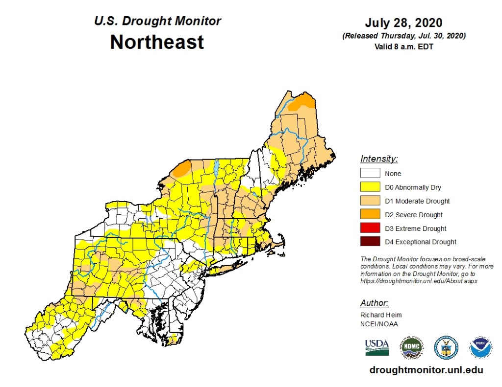
Dry weather for the latter half of the week will not help with the developing drought. Image provided by the National Drought Mitigation Center.
Monday: Partly to mostly sunny, breezy, and hot. High 86-93.
Monday night: Becoming mostly cloudy with a few showers possible. Low 67-74.
Tuesday: Cloudy and becoming windy with showers likely, some of them may be briefly heavy. High 79-86.
Tuesday night: Mostly cloudy and windy with showers ending, skies may start to clear late at night. Low 67-74.
Wednesday: Becoming partly to mostly sunny. High 81-88.
While crossing the Bahamas on Saturday, Hurricane Isaias weakened to a tropical storm, but it remains a threat to much of the East Coast.
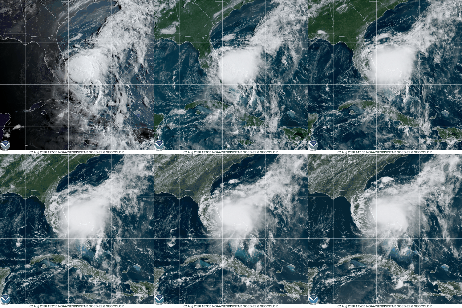
Tropical Storm Isaias continues to spin off the Florida Coast this afternoon. Loop provided by NOAA.
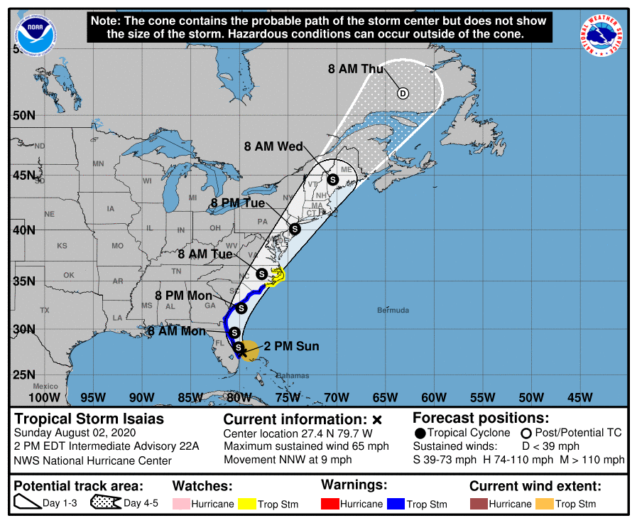
As of 2pm Sunday, Tropical Storm Isaias was centered about 45 miles east-southeast of Vero Beach, Florida, moving toward the north-northwest at 9mph. Maximum sustained winds were near 65 mph, and should remain near that level for the next day or two, with some fluctuations in strength possible. Tropical Storm Warnings are in effect from Jupiter Inlet, Florida to Surf City, North Carolina, with a Tropical Storm Watch north of Surf City to Duck, North Carolina, including Albemarle and Pamlico Sounds. A Storm Surge Watch is in effect from Edisto Beach, South Carolina to Cape Fear, North Carolina.
Isaias moved across the Bahamas as a hurricane late Friday into early Saturday, before weakening to a Tropical Storm Saturday afternoon. The combination of southwesterly wind shear and some dry air due to Saharan Dust contributed to the weakening. Isaias is maintaining its strength this afternoon despite the presence of more wind shear.
Forecast track for Tropical Storm Isaias. Image provided by the National Hurricane Center.
Isaias should continue to head towards the north today, in between a large area of high pressure of the east, and an approaching trough of low pressure from the west. As the trough continues to move towards the East Coast, it will help turn Isaias more towards the north-northeast and eventually northeast. On this track, Isaias will parallel the coast of Florida and Georgia today and tomorrow, then likely make landfall in either South Carolina or North Carolina late Monday night or early Tuesday. Once inland, Isaias will continue northeastward, and although it will weaken a bit, it should maintain some strength as it moves up the coast, as it starts to transition into an extratropical storm.
Storm surge will be a threat along the Carolina coast, near and east of where the center makes landfall. A surge of up to 4 feet above normal tide levels could result in some coastal flooding. Strong winds will also be a threat, mainly east of the storm’s center. Winds have been gusting as high as 50 mph along the Florida coast this afternoon. As it moves northward, some strong winds will be likely across eastern North Carolina as the storm moves inland, and possibly across eastern New England late Tuesday into early Wednesday as the system moves across the Northeast.
Most of the strongest winds should remain offshore. Image provided by WeatherBell.
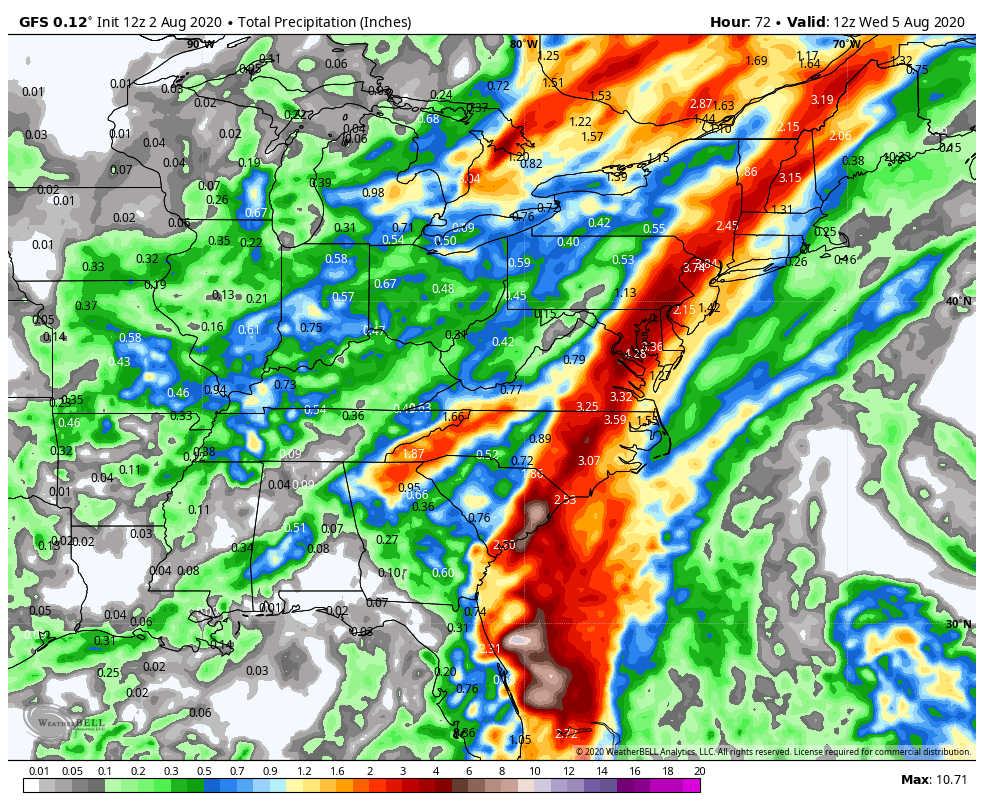
By far, the biggest threat with Isaias is heavy rainfall and the resulting flooding. Some bands of heavy rain have moved across parts of Florida, and that will continue through tonight. Rainfall totals of 1-3 inches are possible across parts of Florida and Georgia over the next 24-36 hours. As you head north, heavier rain is likely from the Carolinas into the Mid-Atlantic states and the Northeast, mainly along and west of the storm’s track. Rainfall totals of 3-6 inches and locally heavier are likely, which will produce flooding in many areas. The storm’s relatively quick motion will preclude even heavier totals. East of the storm’s track, rainfall will be much lighter, with many places likely seeing less than 1 inch.
Isaias will produce heavy rainfall across much of the East Coast over the next few days. Image provided by WeatherBell.
Elsewhere, we’re keeping an eye on a tropical wave located a few hundred miles east of the Leeward Islands. Conditions could become favorable for it to develop into a tropical depression in a few days. Model forecasts show it heading northwestward, staying north of the Caribbean over the next few days. By mid-week, most forecasts show it stalling out about midway between Bermuda and the Bahamas. It does not look like a threat to any land areas at this time.
The 2020 Hurricane Season has had two themes so far: 1. Tropical Storms that aren’t really tropical. 2. Storms that fall into the “Blink and you’ll miss it” category. We’ve got another one out there, and this is squarely in category #2.
Fay looks like a typical tropical system impacting the Northeast, with the bulk of the clouds and precipitation north and west of the center. Loop provided by NOAA.
A disturbance that moved from the Gulf of Mexico and into the Southeast last week moved off the South Carolina coast on Wednesday. After sitting over the warm waters of the Gulf Stream, thunderstorm activity began to increase, and a new center of circulation developed Thursday afternoon. Air Force Reserve Hurricane Hunters investigating the system determined that it had a closed circulation (barely), and the system was designated as Tropical Storm Fay.
Forecast track for Tropical Storm Fay. Image provided by the National Hurricane Center.
Fay is the 6th named storm of the season (Whether all 6 deserved to be named is highly debatable), and is the earliest we’ve ever had an “F” storm in the Atlantic. The previous record was held by Tropical Storm Franklin during the 2005 season, which developed on July 22. Despite the record start in terms of named storms, most of the storms have been short-lived and of little impact. Meteorologists use a metric called ACE (Accumulated Cyclone Energy) to determine the severity of a hurricane season. It takes into account how strong storms are, how long they remain strong, and how long they last. Despite having 6 named storms so far, the Atlantic has an ACE of 7.4 this season. While this is more than double the normal through July 10 of 3.1, it is exactly the same as the Western Pacific Ocean, where only 2 storms have formed so far this year.
Tropical Cyclone Activity is below normal across the Northern Hemispehere thus far, despite the “active” Atlantic. Image provided by Colorado State University.
While there are still a few minor details that need to be determined, Fay’s future is fairly clear. With a ridge of high pressure in the western Atlantic, and a trough of low pressure moving into the Great Lakes, Fay should head northward for the next 24 hours, hugging the Mid-Atlantic coastline. The official forecast from the Hurricane Center has Fay make landfall near Atlantic City later today, but a slight jog to the east will keep the center offshore longer, with landfall farther to the north. A Tropical Storm Warning is in effect from Fenwick Island, Delaware to Watch Hill, Rhode Island, including Long Island Sound. This includes southern Delaware Bay as well all of Long Island and southern Connecticut, and also New York City.
Most of the rainbands assoc
Fay currently has maximum sustained winds near 60 mph (Edit: Yeah, right), and little additional strengthening is expected before landfall. The storm is moving northward at 12 mph, and should pick up a little speed today. This track will keep most of the strongest winds offshore, but right along the coast winds will remain brisk. Sustained winds near 40 mph were reported along the Delaware coast earlier this morning.
Fay will help put a dent in the developing drought across the Northeast. Image provided by the National Drought Mitigation Center.
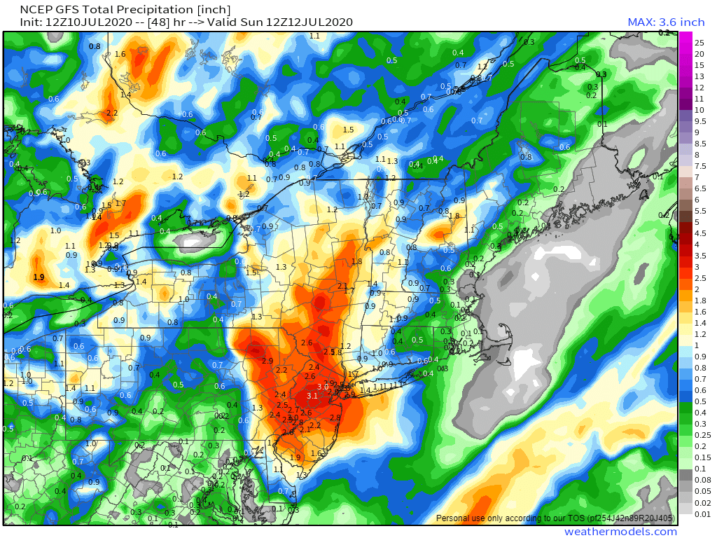
Fay’s biggest threat will be heavy rainfall that could lead to flash flooding, especially from the Mid-Atlantic states into eastern New York and western New England. Much of this region has been dry for a few months, and drought conditions are beginning to develop. Some of this rainfall will help alleviate that, but too much rainfall too quickly will just run off and not help much at all. By the time Fay pulls away early Saturday, rainfall totals of 2-5 inches are expected from the Delmarva Peninsula into western New England and eastern New York, mainly along and just west of the expected track of Fay. Some isolated totals in excess of 6 inches are possible. Amounts will taper off the farther east or west you head away from this area.
The heaviest rain is expected from the Mid-Atlantic states into the Hudson Valley. Image provided by Weathermodels.com
Once Fay dissipates, there don’t appear to be any other areas that may develop in the next week or two. It’s still early in the season, and easterly waves will begin rolling off of western Africa soon, with the climatological peak of hurricane season still more than a month away.
Yes, snow is still on the way, and this is an update to our forecast, but it really hasn’t changed that much.
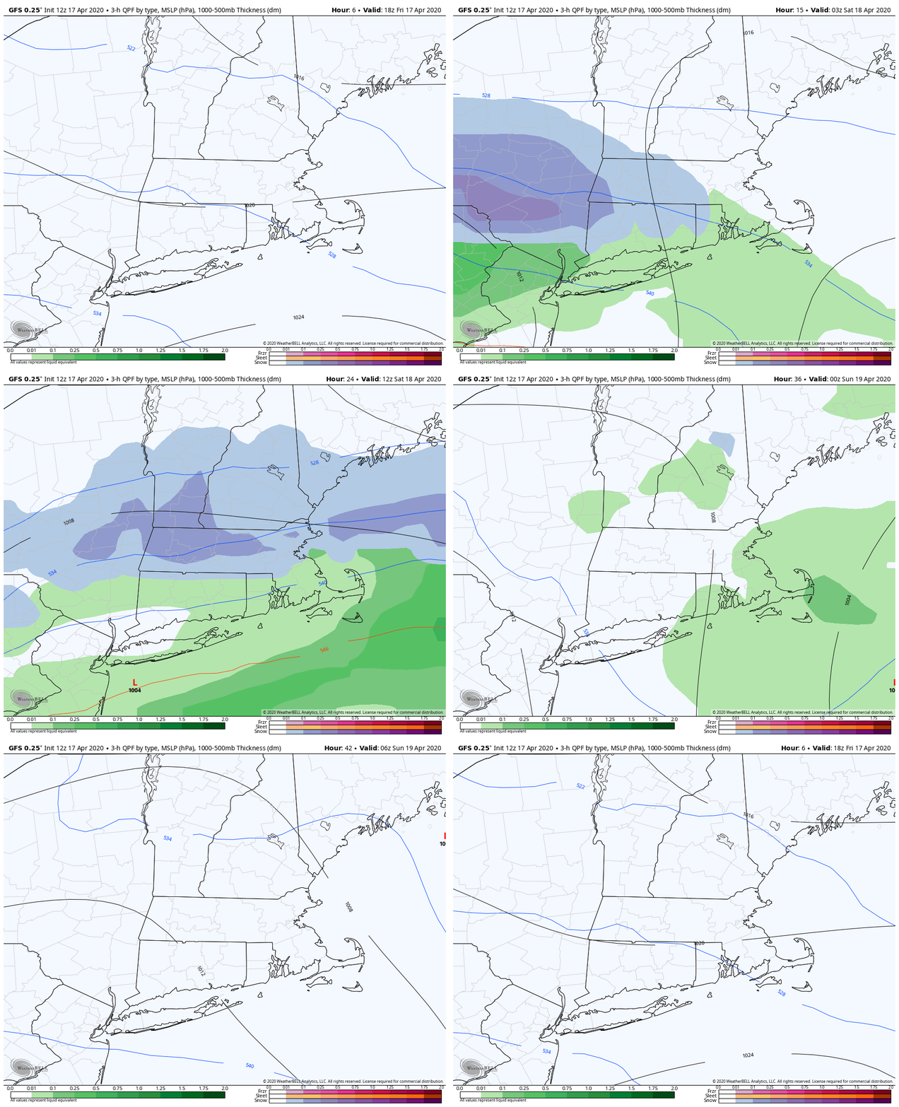
Low pressure will move out of the Ohio Valley today, passing south of New England early on Saturday. We’ll have some cold air in place, so many of us will have some snow Saturday morning, but don’t worry, it won’t be a lot, and it won’t hang around for too long.
The precipitation will move in around midnight, and it will likely start as rain for most of us, with temperatures still in the upper 30s to lower 40s. However, it will quickly change over to snow as temperatures drop into the middle 30s. It looks like there may be a burst of moderate to heavy snow overnight, especially along and south of the Massachusetts Turnpike. A change back to rain is expected towards daybreak, except in the hills from northern Rhode Island into Worcester County and the Monadnocks in southwestern New Hampshire.
The GFS model shows the progression of snow and rain across the region. Loop provided by WeatherBell.
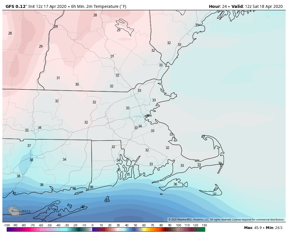
As we mentioned yesterday, it’s awfully tough to get accumulating snow in mid-April for a variety of reasons, but there are some things that will help this time. First of all, most of the snow will fall at night. Once the sun comes up, the sun angle is similar to late August, so once we get past about 7-8am, even if there are still flakes falling, there won’t be any more accumulation. Second of all, temperatures will be close to freezing. Third, the snow may come down at a decent clip, which will help bring down a little bit of colder air from aloft. Working against accumulating snow is the fact that the ground is warm. Any accumulations will be mainly confined to grassy surfaces, as the pavement is considerably warmer. There may be a little slush on paved surfaces, but not much. Also, we’re not going to have a large window of time for accumulating snow. As we said, the precipitation will start as rain around midnight before flipping to snow. Once it does start snowing, it will take a little time to start accumulating, due to the wet/warm ground. That will take until 1-2am, and by 7am, the daylight will help put an end to accumulations. So, we’ve really only got about 5-6 hours of accumulating snow out of this system.
Temperatures likely won’t drop below freezing across most of the region tonight. Image provided by WeatherBell.
So, how much do we expect now? Our thinking really hasn’t changed too much from yesterday. The jackpot is still going to be in the Worcester Hills and the Monadnocks, where 3-5″ is expected, possibly some heavier amounts. For the rest of us, a general 1-3″ from southern New Hampshire into the Merrimack Valley and Metro West, as well as the Seacoast of New Hampshire. The immediate Boston area will probably see around 1 inch. The biggest question mark for us is the area south of the Mass Pike into northern Connecticut, northern Rhode Island, and parts of southeastern Massachusetts. There will be some heavier precipitation here, but temperatures may also be a bit milder. Right now, we’re thinking 1-2″ for places like Woonsocket, Brockton, and Taunton, but it could end up a bit more if there is that heavier burst of snowfall. It also could end up less if temperatures stay in the upper 30s instead of dropping into the middle 30s.
The GFS model remains closest to our thinking for snowfall amounts. Image provided by Weathermodels.com
The rest of Saturday will feature rain showers and temperatures in the upper 30s to lower 40s, which will help melt away some of the snow from the morning. Skies will clear out at night, but clouds will come back in Sunday afternoon ahead of the next storm system. The good news is that Sunday will see temperatures well into the 50s and lower 60s, so that should take care of the rest of the snow. That next system? It’ll stay well offshore, but may produce a few rain showers on Monday. Is this the last time we’ll see snow until the fall/winter? Possibly. History says it can snow as late as mid-May here, so we can’t completely rule it out. In yesterday’s blog, we mentioned the possibility of flakes around April 28-29, based on the ECMWF Ensemble and its 51 members. Well, the newest run of that model no longer has that threat, but a significant portion of the ensemble members have at least a trace of snow for parts of the area around May 2, with a little bit of wet snow mixed in during a rainstorm. So, there’s a good chance tonight is our last accumulating snow for several months, but it might not be the last time we see some snowflakes. That same model also shows high temperatures near or above 70 on a regular basis starting around the middle of May.
We’ve got quite the storm coming in to start the week, but it’s not the only one that may impact us before the week is out.
The high-resolution NAM model depicts the progression of rain across the region with some embedded thunderstorms during the afternoon. Loop provided by Tropical Tidbits.
Low pressure will head through the Great Lakes and into Ontario today, bringing some very adverse weather into the region. We’ll have periods of rain, possibly heavy at times throughout the day, with some thunderstorms possible as well. The biggest threat will be the wind. High Wind Warnings have been posted for nearly all of Southern New England, with Wind Advisories for southern portions of New Hampshire and Maine. Sustained southerly winds of 25-35 mph are likely, with gusts to 50 mph or more common, especially in southern New England. This would be enough to take down some trees and power lines, but it could end up being worse. Not far above the surface, winds will be screaming out of the south at 90-100 mph. We’ll have some relatively stable air below that, keeping those winds aloft from getting down to the surface for the most part. However, some of the heavier downpours, especially in thunderstorms, will help bring some of those strong winds down during the afternoon, which could result in wind gusts of 60-70 mph or more, especially across southeastern Massachusetts and Rhode Island.
Wind gusts could exceed 60 mph across much of the region this afternoon. Image provided by WeatherBell.
A cold front moves through during the evening, bringing an end to the rain, and allowing winds to rapidly diminish at night as they shift into the west. High pressure then builds in for Tuesday with some sunshine, but it will remain breezy as Monday’s storm moves into northern Quebec. Clouds come right back in Tuesday night as low pressure rides along a front stalled out south of New England. It looks like this system will remain fairly far to the south, with the best chance for any shower activity across the South Coast, Cape Cod, and the Islands. Another weak disturbance may bring in a few showers on Thursday. High pressure then builds in for Friday and the weekend, but we’ll have to keep our eyes on a couple of systems that look like they’ll stay south of the region right now.
Monday: Windy with rain, heavy at times, possibly some thunderstorms. High 56-63.
Monday night: Rain ending in the evening, then becoming partly cloudy with diminishing winds. Low 37-44.
Tuesday: A mix of sun and clouds, breezy. High 51-58.
Tuesday night: Partly to mostly cloudy. Low 35-42.
Wednesday: Plenty of clouds with a few showers possible along the South Coast and across Cape Cod. High 45-52.
Thursday: More clouds than sunshine, breezy, slight chance for a few showers. High 43-50.
Friday: Sunshine and some afternoon clouds, breezy. High 45-52.
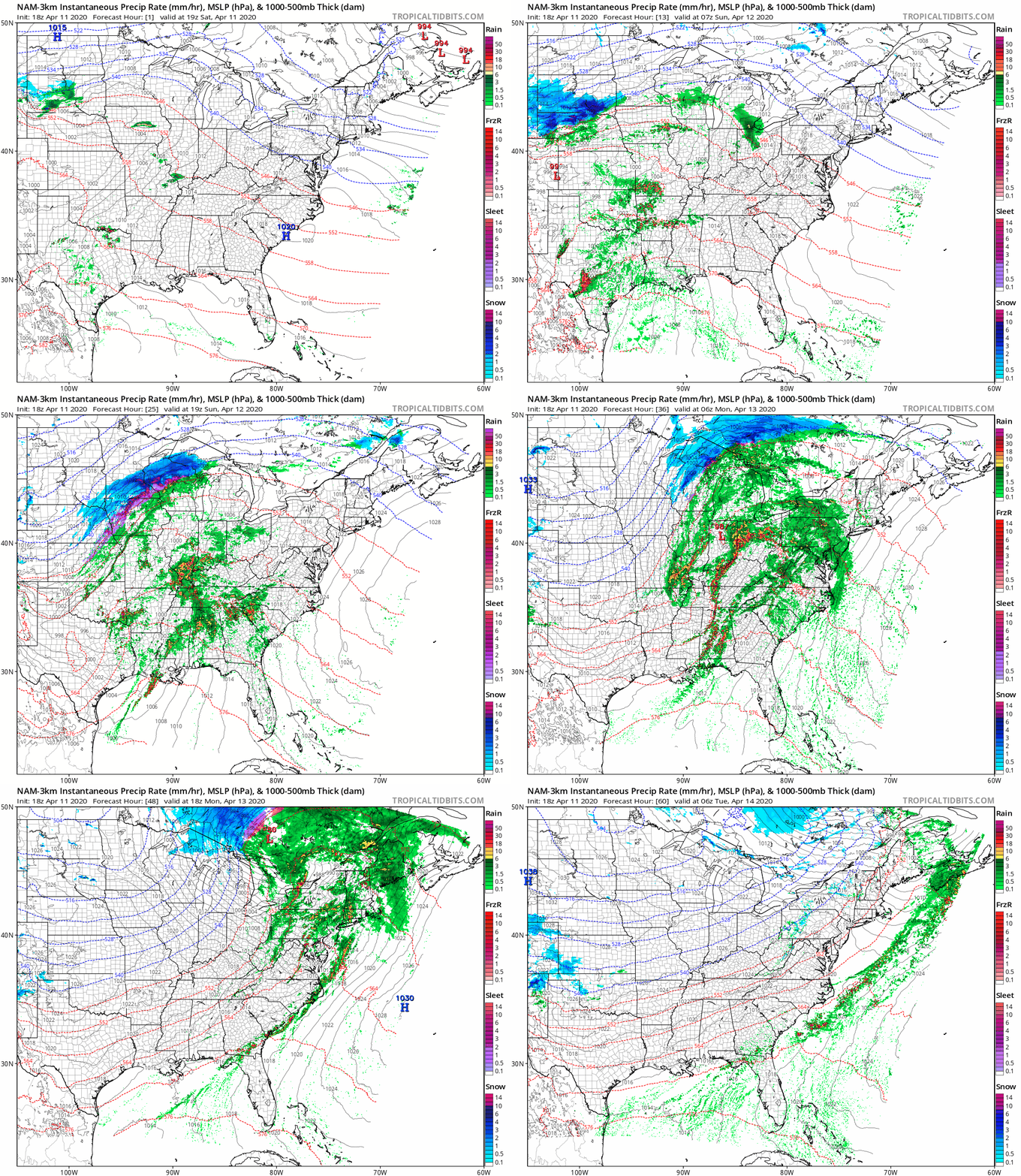
A rather strong storm system will wreak all sorts of havoc on a large swath of the nation through the weekend and into Monday.
Low pressure will move out of the Plains states today and into the Great Lakes later Sunday into early Monday. Loop provided by Tropical Tidbits.
Low pressure is moving into the Plains states today, producing some strong to severe thunderstorms from Texas into the Southern Plains. That’s just the start of what will be a busy few days. As the storm moves into the southern Plains tonight, showers and thunderstorms, some strong to severe, will spread from Texas into the Mississippi Valley. To the north, snow is expected across the Central Plains. Some locations could pick up 6-12 inches this weekend in a swath from Nebraska and South Dakota into parts of Iowa, southern Minnesota, and Wisconsin.
A severe weather outbreak is possible across a large portion of the South on Easter Sunday. Image provided by the Storm Prediction Center.
Easter Sunday is the day that will likely grab most of the headlines away from the pandemic for a day. As the system moves into the Ohio Valley, warm, moist air will be drawn northward from the Gulf of Mexico, and as this clashes with the cold air advancing southward behind the storm, the ingredients will be in place for a severe weather outbreak. Severe weather may be ongoing as Easter Sunday dawns across the Lower Mississippi Valley, but activity will spread eastward during the day across the Deep South and the Tennessee Valley. Some of the stronger storms may produce damaging winds, large hail, torrential downpours, and likely numerous tornadoes. The risk will continue well into the overnight hours, especially in Georgia, eastern Tennessee and western portions of the Carolinas.
The severe weather threat shifts to the East Coast on Monday. Image provided by the Storm Prediction Center.
By Monday, the system will move into Ontario, dragging a strong cold front across the Eastern United States. Warm, humid air will continue to flow northward ahead of this front, triggering more showers and thunderstorms during the morning and early afternoon from northern Florida into the Mid-Atlantic states. Some of these storms could produce hail, strong winds, heavy downpours, and some tornadoes, especially from the Carolinas to the Delmarva Peninsula.
Heavy snow is likely from Wisconsin in the Upper Peninsula of Michigan Sunday into early Tuesday. Image provided by Weathermodels.com
To the north, heavy snow will continue behind the storm from northern Wisconsin into the Upper Peninsula of Michigan and Ontario. Snowfall totals of 10-20 inches or more are likely. Winds gusting to 40-50 mph will create significant blowing and drifting of the snow, with blizzard conditions at times.
Precipitation has been below normal across much of the Northeast during the first 100 days of 2020. Image provided by the Northeast Regional Climate Center.
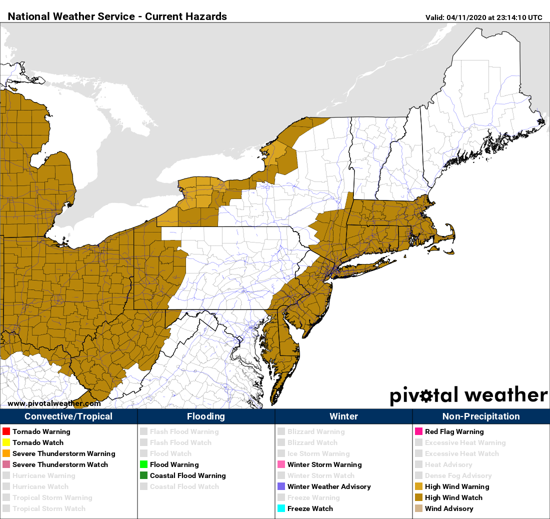
Here in the Northeast, the big story will be the wind. Rain will be a secondary concern, with rainfall totals of 1-2 inches possible across much of the region. Some embedded thunderstorms may produce heavier downpours, especially in western New England and eastern New York, but flooding isn’t much of a concern. Precipitation has been below normal across much of the area through a good chunk of the winter and early Spring, so we need all the rain we can get, though maybe not quite this much at once. There will be some ponding on the roadways, and some of the smaller streams may overflow, but widespread flooding shouldn’t be a problem. The wind, on the other hand, will be a major problem.
High Wind Watches are in effect for parts of the Northeast, and these will likely expand over the next 12-24 hours. Image provided by Pivotal Weather.
As the system gets cranked up in Ontario, strong southerly winds will develop across the region. These will bring milder air into the region. We won’t quite reach the 90s that will set records across Florida on Monday, but 50s and 60s are still a bit above normal for mid-April around here. Southerly winds will increase Monday morning, with sustained winds of 25-35 mph expected during the afternoon. Wind gusts of 60-70 mph or higher are expected as well. This will likely result in power outages as they take down trees that are starting to show their leaves, along with power lines. Winds should start to diminish during the evening as a cold front moves through, bringing an end to the rain and shifting the winds into the west.
Wind gusts of 60-70 mph or higher could be widespread Monday afternoon. Image provided by WeatherBell.
Conditions should improve on Tuesday as high pressure builds in with some sunshine developing, but it will still be breezy as the now-powerful storm moves into northern Quebec, where heavy snow will likely continue.
An approaching storm system will make for quite the interesting Thursday across New England.
The low pressure system that will generate severe weather across parts of the Mississippi and Ohio Valleys this afternoon and evening will head northeastward tonight, and pass right over New England on Thursday. It will produce a variety of weather across our six-state region, depending on where you’re located. Across southern New England, we’ll have heavy rain, possibly some thunderstorms, and strong winds. Across northern New England, this could turn out to be quite a snowstorm.
The High-Resolution NAM model shows the progression of the system over the next couple of days. Loop provided by Tropical Tidbits.
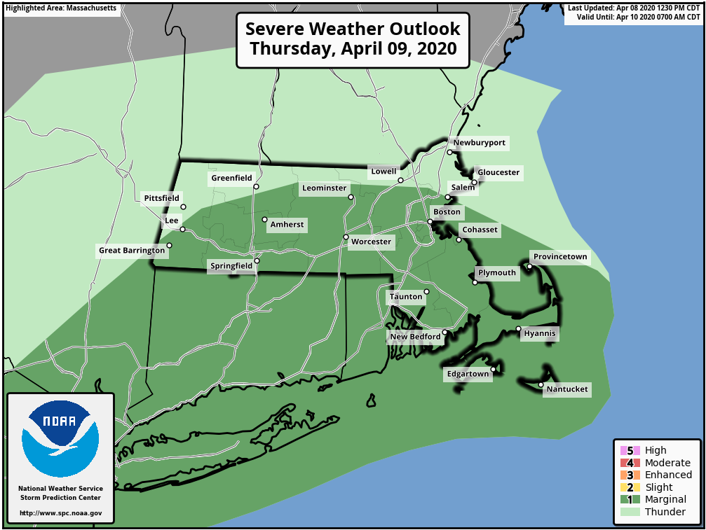
Starting with southern New England, we’ll see showes developing during the morning, becoming a steady rain during the afternoon. With warmer air moving at the surface, thunderstorms may develop as the system moves in. Some of these storms may produce gusty winds, and hail, as there will be plenty of cold air aloft with an upper-level low pressure system moving into the Northeast.
The Storm Prediction Center has placed most of Southern New England under a marginal risk for severe weather on Thursday. Image provided by the Storm Prediction Center.
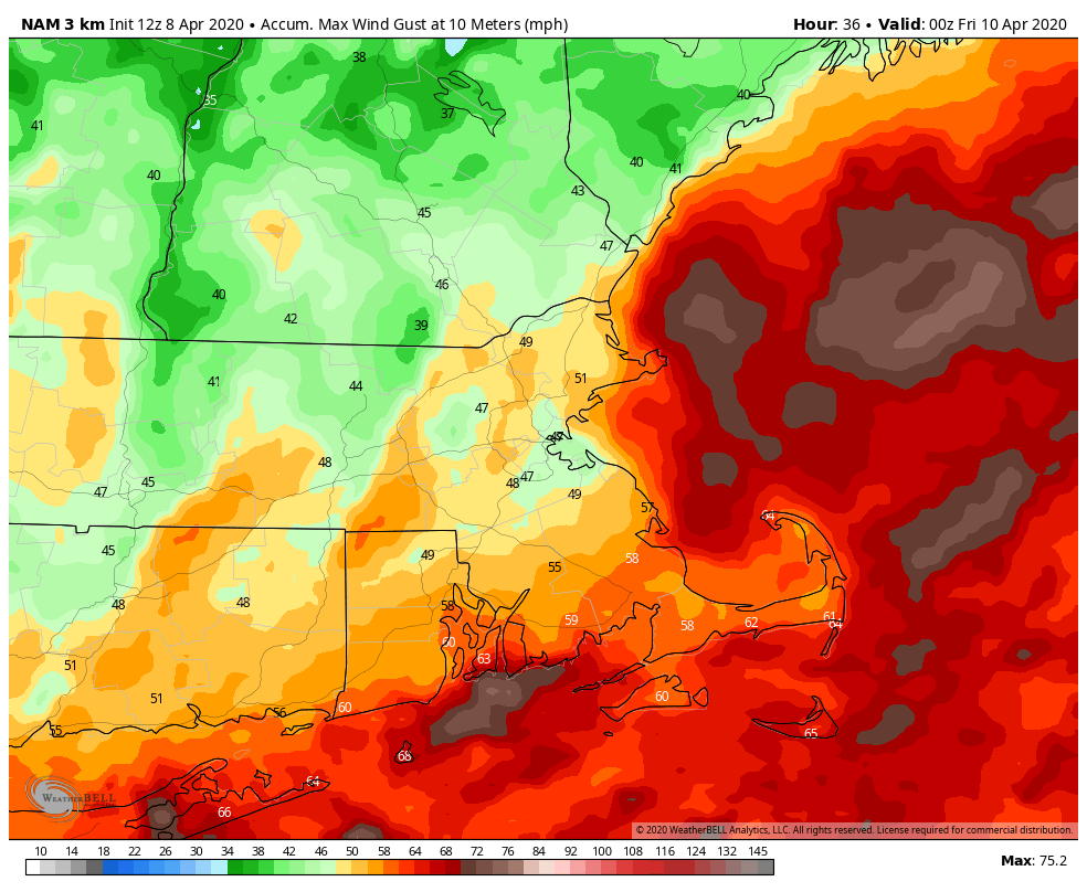
The rain and thunderstorms should come to an end by late afternoon, but that’s only half of the threat. A cold front will cross the region, with strong winds likely behind it. Sustained winds of 20-30 mph, with gusts of 40-50 mph or higher are likely. These winds may diminish a bit overnight, but will likely pick back up on Friday as the storm continues to intensify across eastern Canada. That upper-level low pressure area will also be overhead, so we’ll have plenty of clouds and a few showers popping up. With the cold air aloft, some of those showers could produce some small hail or graupel.
Wind gusts could exceed 50 mph in places Friday afternoon. Image provided by WeatherBell.
While we are dealing with strong winds and thunderstorms, it’ll be a completely different story across northern New England. Temperatures will be much cooler across Maine, New Hampshire, and Vermont, with much of the precipitation falling in the form of snow, especially in the mountains. Some of the snow will be quite heavy, with a foot or more possible, especially across Maine and northern New Hampshire. Winter Storm Watches are in effect for parts of the region. The snow will also be accompanied by strong winds, gusts to 40 mph or more, which may create blizzard conditions at times. There’s already little travel going on due to the pandemic, but there should be even less over the next few days.
Parts of northern New England, especially Maine and northern New Hampshire, could pick up more than a foot of snow Thursday into Friday. Image provided by WeatherBell.
The snow should wind down on Friday, but with the upper-level low in place, snow showers may continue. Some of those snow showers may spread into the Berkshires as colder air works its way in. Some wet snow is even possible into the Worcester Hills and Monadnocks.
High pressure will build in for the weekend with drier weather, but our next system looks to move in on Monday. That one looks like a rain-maker right now, and it might produce a decent amount of rainfall. We’ve been a bit dry this winter, so we need all the rain we can get right now to avoid slipping into a drought.
A pair of storm systems are heading our way, but for most of us, snow will be the least of our concerns. Your Thursday morning commute will be a mess however.
Winter Weather Advisories are in effect for much of the Northeast away from the coast, with Winter Storm Watches up north. Image provided by Pivotal Weather.
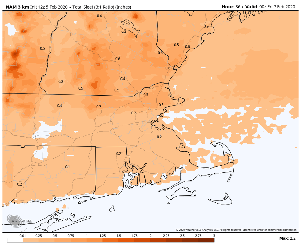
Low pressure will ride along a frontal system that is stalled out south of New England tonight and Thursday. Meanwhile, high pressure is in place to the north, bringing some colder air into the area. As the precipitation shield ahead of the low moves in after midnight, it will fall in the form of snow across most of the area, except along the South Coast, where it will be mainly rain with some sleet mixed in. This snow won’t last too long though, as warmer air will be moving in aloft. This will change the snow to sleet and then freezing rain from south to north as the morning progresses. We’re not expecting much snow accumulation, but the combination of snow, sleet and freezing rain will make a mess out of the morning commute.
The first part of the storm could produce a decent amount of sleet from the Merrimack Valley into southern New Hampshire. Image provided by WeatherBell.
The warmer air eventually pushes in at the surface by early afternoon for most of us, changing everything to plain rain. Across southern New Hampshire, things could get tricky. Temperatures may not get much above freezing, or even above freezing at all, which would keep the freezing rain going, resulting in very slippery conditions. The precipitation should taper off by late afternoon, with only some drizzle or freezing drizzle through the evening and the first part of the overnight.
While we deal with a wintry mix, severe weather is expected across much of the Southeast on Thursday. Image provided by the Storm Prediction Center.
This brings us to the 2nd part of our double whammy. The storm that is producing severe weather across the Gulf Coast today will head towards Southern New England on Friday. Rain will redevelop after daybreak, and it could be heavy for a while during the morning. This will have some impact on the Friday morning commute, but not to the extent of the wintry mix on Thursday. Across southern New Hampshire, we may have some more significant problems though. We may still have cold air in place at the surface, which could lead to more freezing rain and sleet as the heavier precipitation moves back in. If the precipitation is heavier enough, it could drag some of the warmer air aloft down to the surface, changing everything to plain rain, but the Friday morning commute could be a mess along I-93 and US-3 north of the Massachusetts border.
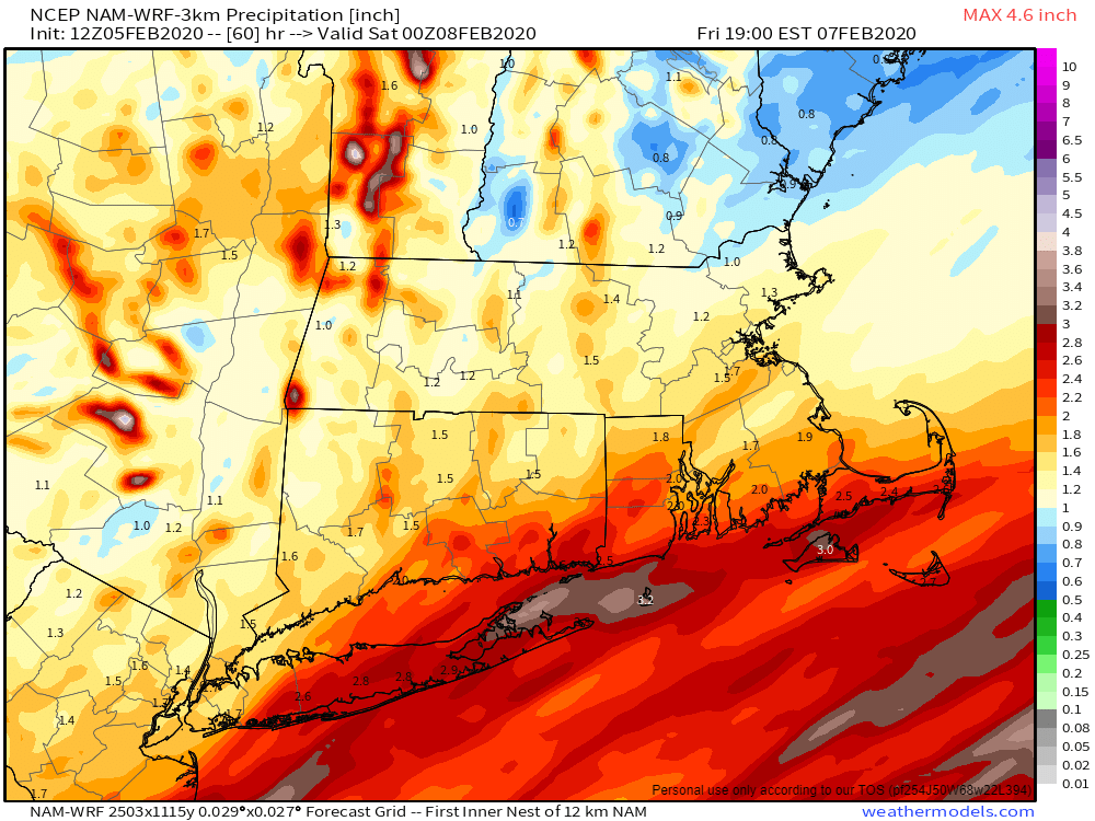
Rainfall totals of 1-2 inches, maybe even heavier, are possible across the region between now and Friday evening. Image provided by Weathermodels.com
As the low moves across Southern New England, places south of the center of the low, mainly Connecticut, Rhode Island, and southeastern Massachusetts, will see temperatures jump into the 40s or even the 50s. However, as the low passes by, colder air will quickly move in both at the surface and aloft. This will allow the precipitation to change to snow from northwest to southeast. The cold air will be moving in as the precipitation comes to an end though, which will limit any accumulations.
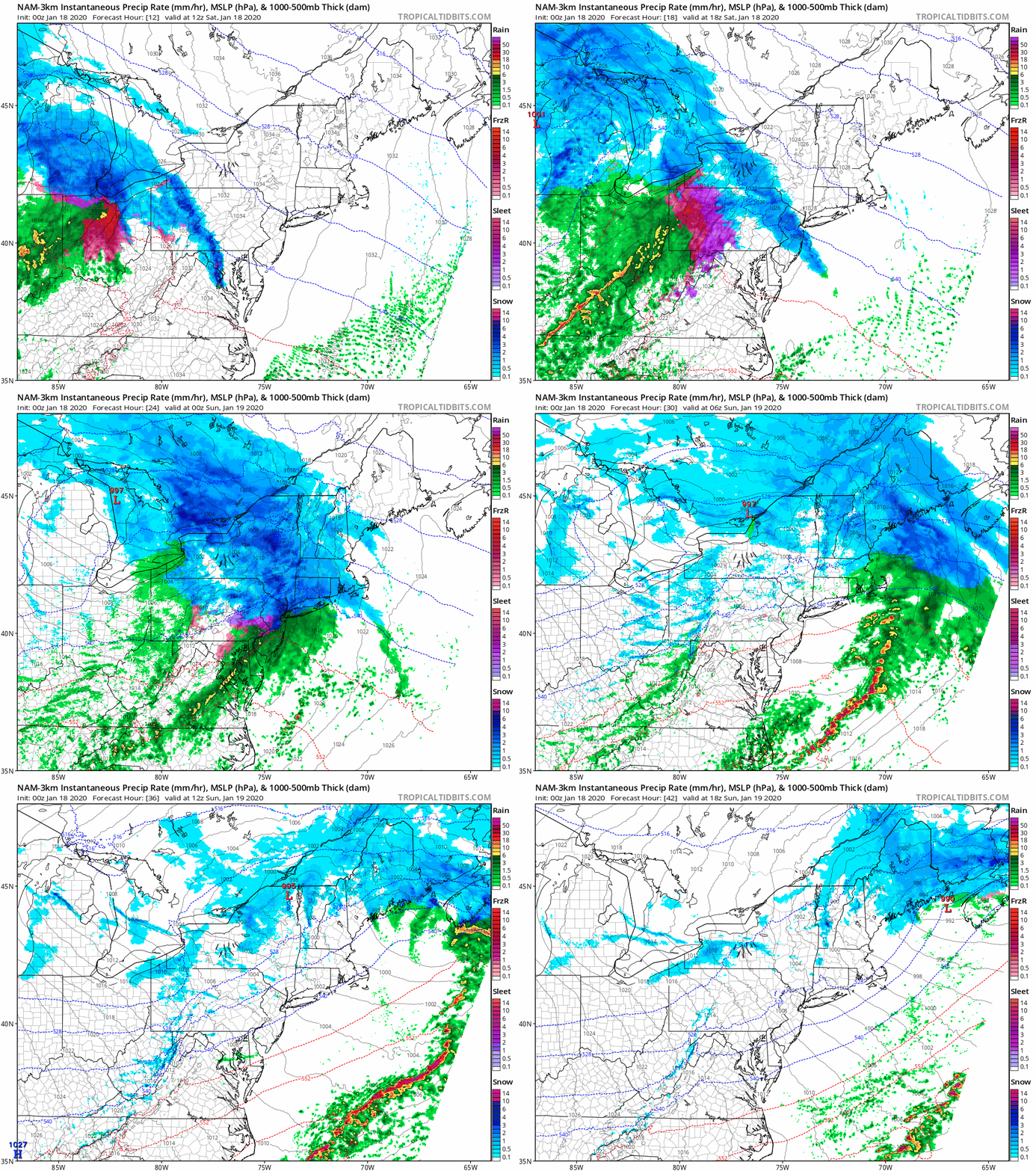
The High-Resolution NAM model shows the progression of our double-barreled storm and the variety of precipitation it will produce. Loop provided by Tropical Tidbits.
If you’re a skier, you’ll be happy, as this storm will be mainly snow and sleet up north, with significant accumulations possible in ski country.
Many locations up north could see 6-12 inches of snow or more between now and Saturday. Image provided by Pivotal Weather.
The pattern we’re in will be active for a while, with storm systems coming in every 2-3 days for the next week or two. Some of these will contain wintry precipitation, it is February after all.
We’ve got a significant snowstorm on the way to the region for Saturday night. Hang on, we’re being told that even though the last week or so has felt like January in North Carolina, we’re still in Massachusetts, not North Carolina. So, let’s start over. We’ve got some snow on the way for Saturday night, but it shouldn’t be a big deal by New England standards.
Winter Storm Warnings and Winter Weather Advisoies are in effect for much of the Northeast. Image provided by Pivotal Weather.
A cold and very dry airmass is in place across New England to start Saturday, thanks to a high pressure area moving across Northern New England. Temperatures are starting the day in the single numbers and teens, with dewpoints near or below zero. Meanwhile, a storm system will be moving out of the Great Lakes and heading for Northern New England later today. That will be out weather-maker for tonight and early Sunday.
Saturday is starting on a very chilly note across the region. Image provided by Weathermodels.com
We’ll see high clouds start streaming in by midday, and they’ll thcken up during the afternoon. It’ll take some time for the air to moisten up, but it will eventually, and snow will start falling right around dinnertime for most of us, a little earlier to the west. This will be a fast-moving storm, with the snow actually tapering off and ending around midnight. It looks like any rain/snow line will be confined to southeastern Massachusetts and Rhode Island. After midnight, a little freezing drizzle or some flurries are possible as the system starts to pull away, but the accumulating snow should be all done.
Our storm quickly moves across the region this evening and tonight. Loop provided by Tropical Tidbits.
The snow could fall at a decent clip during the evening hours, with some places possibly seeing an inch per hour. So, if you’tre going to be out and about, take it slow and drive carefully. How much snow are we expecting?
The High-Resolution NAM model is probably closest to our thinking on snowfall with this system. Image provided by WeatherBell.
Behind the storm, Sunday will be a nice day, with developing sunshine and temperatures in the 30s to near 40, which will help melt some of the new snow. You’d better get out and clean up the driveway though, because everything is going to freeze solid Sunday night as another arctic airmass settles into the region. Temperatures may not get back above freezing until Wednesday afternoon, possibly not until Thursday, but a warmup is expected for the end of the week.
As we head into the home stretch of 2019, it looks like the year is going to end with a wintry mess.
Winter Storm Watches are in effect across interior portions of New England and eastern New York. Image provided by Pivotal Weather.
The storm system that produced heavy snow in the Plains and strong to severe thunderstorms in the Mississippi Valley on Saturday will head into the Great Lakes on Sunday, then just mill around in the Midwest for Monday and early Tuesday. Clouds will stream into our area later Sunday ahead of the system, but as is usually the case with a storm that far west, the warmer air that we usually find on the east side of a storm system won’t make it in here, at least at the surface (that becomes important later on).
Sunday will be a mild day (by late December standards) as high pressure moves out, but temperatures should drop below freezing during the evening. We’ll see precipitation start to break out before midnight across much of the area. While there will still be cold air in place at the surface, warmer air will be starting to move in aloft. So, we should see sleet and some freezing rain developing, with some snowflakes, mainly from central and southern New Hampshire northward. Some accumulations are possible, especially from the Seacoast up into the Lakes Region, but only a few inches at most before a change to sleet occurs. Along the South Coast, this will be mainly rain with temperatures above freezing.
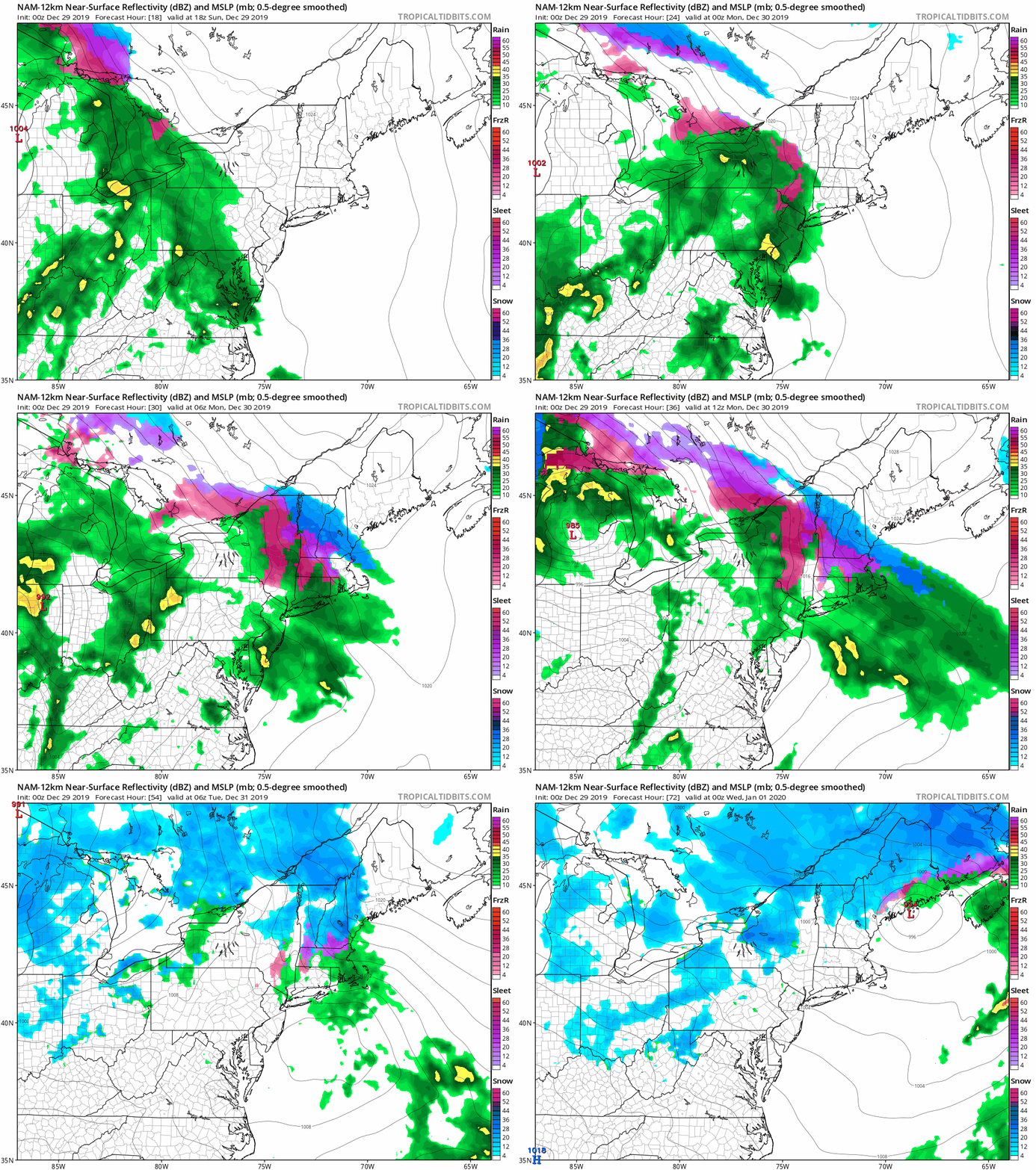
The NAM model shows the progression of the storm system and how the precipitation changes from sleet to freezing rain, to rain across the region. Loop provided by Tropical Tidbits,
With a frontal system stalled out south of New England, we’ll have generally east to northeast winds on Monday. This will allow parts of southeastern Massachusetts and Rhode Island (mainly south and east of Interstate 95), to warm above freezing as somewhat milder air moves in off the ocean. Across inland areas, it’ll be a much different story.
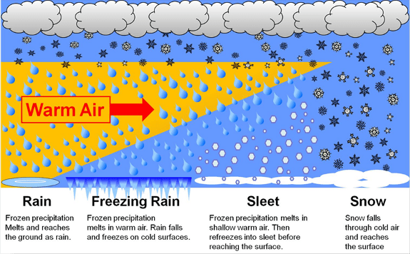
This graphic shows the difference in how you get snow vs sleet vs freezing rain. Image provided by NOAA.
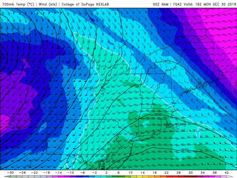
Cold air will remain in place for most of the day on Monday and into Monday night. Meanwhile, a few thousand feet above the ground, warmer air will be moving in. This will mean sleet at first, but as that warmer air layer grows thicker, the sleet should transition over to freezing rain. When that transition occurs is still a bit of a question mark.
NAM model forecast for temperatures at 700mb (about 10000 feet) for midday Monday. Temperatures will be above freezing across most of our region that high up, melting any high-level snowflakes falling into that part of the atmosphere. Image provided by the College of DuPage.
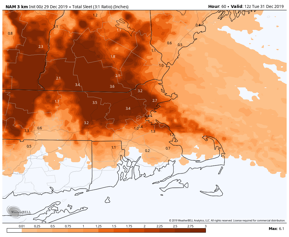
Some models are showing the potential for significant amounts of sleet from interior eastern Massachusetts into southern New Hampshire, with significant ice accretion from freezing rain across the Worcester Hills, Monadnocks, and the Berkshires. No matter what happens, travel will be very slippery across the interior on Monday,
The High-Resolution NAM model is forecasting a LOT of skeet across the interior. Image provided by WeatherBell.
By Monday night, a secondary area of low pressure should develop south of Long Island, and it will head northeast, moving across Cape Cod early Tuesday, then into the Gulf of Maine. As it moves close to the area, it should help force the warm air farther inland, allowing temperatures to rise above freezing across most of the area. However, once it moves into the Gulf of Maine, colder air will settle in behind it, both at the surface and aloft, changing everything back to snow showers before the precipitation winds down Tuesday morning.
Significant ice accretion could result in major issues including tree and power line damage across the interior. Image provided by WeatherBell.
We’ll update this forecast as well as a look at New Year’s Eve and New Year’s Day in our Weekly Outlook early Monday morning.



















 Storm HQ