Weekly Outlook: August 20-26, 2018

The heat and humidity have finally departed. Don’t worry, the humidity will be coming back again this week, but only briefly. Then, once it leaves again, the heat might come back. Yup, we’ve got an interesting week coming up.

NEsf.fronts
High pressure is moving into New Brunswick this morning while a cold front is stalled out across North Carolina. Image provided by the College of DuPage

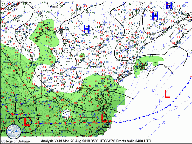
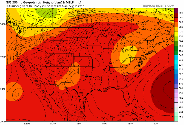
The week starts off with a frontal system stalled out south of New England and high pressure over New Brunswick. When you combine those two, you get a northeasterly flow, bringing in relatively cool and drier conditions. In the Spring, when water temperatures are only in the 40s or 50s this would result in temperatures in the 40s or 50s along the coast, while areas well inland might get into the 70s (or warmer). However, since it’s mid-August, water temperatures are in the lower to middle 70s, so a northeast wind means temperatures will be in the lower to middle 70s along the coast, and upper 70s to lower 80s inland.

MonthTDeptNRCC
It has been a VERY warm August thus far, which makes days like yesterday, today, and tomorrow feel even more refreshing. Image provided by the Northeast Regional Climate Center.

Another cold front will start to move towards the area on Tuesday. We’ll have another relatively cool day, but clouds will start to move in. Tuesday night into Wednesday is when we notice bigger changes. A warm front moves through, bringing heat and humidity back into the area. With the warm and humid conditions will also be some thunderstorms. Much like many days over the past month or so, we’re not expecting any widespread severe weather, but a few places could get hit with a nasty storm that contains gusty winds and heavy downpours.

By Thursday, high pressure builds into the region, with seasonably warm conditions for the end of the week and into the weekend. Humidity levels will be fairly low to start, but should rise a bit for the weekend. While most of the region should remain dry as well, a few showers and thunderstorms are possible, mainly on Thursday as an upper-level low pressure area moves across the Northeast.

t2max_massachusetts_AUG22
On average, high temperatures should be in the upper 70s to lower 80s during the latter half of August around here. Image provided by Weathermodels.com

Monday: A few showers or some drizzle are possible in the morning, mainly south of Boston. Otherwise, intervals of clouds and sunshine, a little breezy, especially along the coast. High 71-78, coolest along the coast.

Monday night: Partly cloudy. Low 56-63.

Tuesday: Partly sunny. High 70-77.

Tuesday night: Mostly cloudy, showers and thunderstorms developing, mainly after midnight. Low 63-70.

Wednesday: Breezy with occasional showers and thunderstorms, some of which could be heavy at times. High 77-84.

Thursday: Partly to mostly sunny, slight chance for a pop-up shower or thunderstorm.  High 73-80.

Friday: Sunshine and a few clouds. High 77-84.

Saturday: A mix of sun and clouds. High 78-85.

Sunday: Partly to mostly sunny. High 79-86.

14E_tracks_latest
Hurricane Lane could be a threat to Hawaii later this week. Image provided by Tropical Tidbits.

Meanwhile, in the tropics, the Atlantic remains fairly quiet, but in the Pacific, we could have some trouble in paradise. As of early this morning, Hurricane Lane was centered a little more than 700 miles east-southeast of Hilo, Hawaii, moving towards the west at about 14 mph. Lane had maximum sustained winds around 120 mph. It is expected to gradually weaken over the next several days, while heading westward, before turning more toward the northwest. Where it makes that northwest turn is very important, as it will determine what, if any, impact Lane may have on Hawaii. At the very least, we’re looking some rough surf and some gusty winds, especially across the Big Island. However, a closer pass brings stronger winds and heavy rain in, possibly to more than just the Big Island. Hawaii doesn’t get direct hits very often. In fact, since their tropical cyclone records began in 1950, only 3 hurricanes have made direct hits on Hawaii – Hurricane Dot in 1959, Hurricane Iwa in 1982, and Hurricane Iniki in 1992 – all of which hit the island of Kauai . Dot and Iwa were both Category 1 storms when they hit, while Iniki was a Category 4 storm. There have been a lot more tropical storms that have hit the islands, and hurricanes that passed close enough to impact part of the island chain, but only those 3 have had direct impacts.

Weekly Outlook: August 13-19, 2018

The forecast for the upcoming week is both simple, and not-so-simple at the same time. If it feels like you’ve heard this before, it’s because you have. The pattern has remained fairly persistent for a while now, but the subtle details make all the difference.

gfs_z500_mslp_us_fh0-168 (1)
High pressure remains off the East Coast, keeping warm and humid air in place for much of the week. Loop provided by Tropical Tidbits.


That stubborn Bermuda High remains in place off the East Coast for much of the week, which means the warm and humid pattern that we’ve been in for a while will continue. However, there are some differences in the pattern that will have other impacts. A frontal system remains stalled out near the East Coast. With an upper-level low pressure system across the Northeast, we’ll have little impulses of energy move through, bringing in some rounds of showers and thunderstorms over the next few days. None of these days will be a washout, and some of the rain will be very localized, but anything that does form could produce some heavy rainfall. This was the case over the weekend, when localized totals of 4 to as much as 8 inches produce flash flooding in a few spots.

SNERain
Many locations received between 1 and 4 inches of rain over the weekend. Some localized totals in excess of 8 inches were reported near Lynn, Massachusetts. Image provided by NOAA.


The upper-level low moves out by mid-week, resulting in less showers and thunderstorm activity, and an increase in temperatures once again. Don’t worry, humidity levels will remain moderate to high right through the week. We could be looking at some places topping 90 again during the latter half of the week. By the weekend, another cold front (an another upper-level trough of low pressure) will approach the region. That means that we could be looking at more showers and thunderstorms. Again, we’re not expecting either day to be a washout right now, so don’t go cancelling any plans just yet. However, we’d have a backup plan ready, just to be safe. With the airmass remaining quite humid, we’d expect any showers and storms next weekend to again  produce some locally heavy rainfall.

So, how much longer will this pattern last? We usually don’t delve into forecasts beyond 7 days, as the models don’t show a lot of skill beyond that, but for now, it looks like we’re locked in for at least a couple more weeks. Beyond that? There are some signs that we could shift into a cooler pattern as we get into early September. Obviously, this is not written in stone, and the cool weather may not even last too long. However, it can’t stay warm and humid forever. The days are getting shorter, meteorological autumn starts in less than 3 weeks, astronomical autumn starts in less than 6 weeks, and most importantly, the Patriots open the regular season 4 weeks from yesterday. Before you know it, we’ll be talking about that 4-letter word that begins with “s” that so many of you hate.

cfs_anom_t2m_conus_2018081218_121
The CFS model shows some much cooler air settling into the eastern half of the nation during early September. Will it actually happen? We’ll see. Image provided by WeatherBell.


Monday: Intervals of clouds and sunshine, chance for some showers, maybe a rumble of thunder. High 73-80.

Monday night: Partly to mostly cloudy, maybe a lingering shower or two. Low 65-72.

Tuesday: Partly sunny, some showers and thunderstorms are possible, mainly in the afternoon. High 78-85.

Tuesday night: Partly cloudy, a few lingering showers are possible. Low 64-71.

Wednesday: A mix of sun and clouds, slight chance for a shower. High 81-88.

Thursday: Partly to mostly sunny, a pop-up shower or thunderstorm may develop in the afternoon. High 83-90.

Friday: Sunshine and some afternoon clouds, a few showers or thunderstorms can’t be ruled out. High 83-90.

Saturday: Partly sunny, chance for some showers and thunderstorms. High 79-86.

Sunday:  More clouds than sunshine, more showers and thunderstorms are possible. High 74-81.

Weekly Outlook: August 6-12, 2018

Another week gone by filled with heat and humidity, as well as some thunderstorms. Can we expect more of the same this week? Yes, at least for part of the week, though some subtle changes are coming.

gfs_z500_mslp_us_fh0-168
Changes in the upper-level pattern will mean changes in our weather later this week. Loop provided by Tropical Tidbits.

The reason for heat and humidity has been a persistent ridge of high pressure in the Eastern US for most of the past few weeks. As you can see in the loop above, that ridge is forecast to shift into the Western US later this week, while a trough of low pressure settles into the Northeast. What does that mean in terms of actual weather? We’ll explain.

NAM-WRF 3-km undefined undefined 20
The combination of heat and humidity will result in heat indices int he upper 90s across most of the region this afternoon. Image provided by Weathermodels.com

With the ridge of high pressure in place aloft, we’ve also had high pressure at the surface, pumping warm and humid air into the region. That will continue today, and likely on Tuesday as well, though a frontal system approaching the region may produce a few showers and thunderstorms later Tuesday. That front will draw closer on Wednesday, likely moving through the region early Thursday. Ahead of it, more showers and thunderstorms are expected, some of which could be locally heavy. Depending on the timing of the front, severe weather is not out of the question. We’ll keep an eye on that as it gets closer.

We’ve had several fronts attempt to move through the region over the past few weeks, but as they run into that high pressure area at the surface and aloft, they end up stalling out and dissipating. With the ridge shifting westward and a trough of low pressure moving into the region, it will help provide enough impetus to help this front move offshore. Now, it’s not much of a “cold” front, as temperatures will still be warm to hot for the end of the week and into the weekend, but the most noticeable effect will be on the humidity. Humidity levels will drop on Thursday, with dewpoints in the upper 60s and 70s replace by dewpoints in the 50s to lower 60s for Thursday and Friday. Another frontal system may approach over the weekend, possibly bringing in some additional showers and thunderstorms, but also raising humidity levels a little.

00Z-20180806_NAMNE_prec_radar-60-84-10-100
We don’t normally get a lot of thunderstorms overnight around here, especially severe ones, but it has happened a few times already this summer. At least one model shows the potential for more activity Wednesday night into Thursday morning. Loop provided by the College of DuPage.

Monday: Some patchy fog early, otherwise sunshine and some high clouds, humid. High 89-96.

Monday night: Mostly clear. Low 68-75.

Tuesday: Sunshine and some afternoon clouds, slight chance for a late-day shower or thunderstorm, humid. High 88-95.

Tuesday night: Partly cloudy, a few showers or thunderstorms are possible, mainly during the evening. Low 68-75.

Wednesday: Partly sunny, with scattered showers and thunderstorms developing late in the day, with more possible overnight. High 84-91.

Thursday: Early showers and thunderstorms, then skies clear out in the afternoon. High 81-88.

Friday: A mix of sun and clouds, slight chance for a shower or thunderstorm. High 82-89.

Saturday: Partly sunny with some showers and thunderstorms possible. High 79-86.

Sunday: A mix of sun and clouds. High 79-86.

Weekly Outlook: July 30 – August 5, 2018

Did you enjoy the past few weeks with the heat and humidity, or were you more happy with the lower humidity that we enjoyed on Sunday? No matter which you prefer, we’ve got both in the forecast for this week, but a lot more of one than the other (Hint: you’re gonna sweat a lot).

gfs_z500_mslp_eus_fh0-180
High pressure will be centered off the East Coast this week and really won’t move that much. Loop provided by Tropical Tidbits.

Once again, as is typical of summer, the general forecast is fairly simple. A “Bermuda High” will be anchored off the East Coast for most of the upcoming week. As a result, we get southwest winds pumping warm and humid air into the region. The high will actually start the week centered right over New England, which is why humidity levels will remain fairly low today. As the high slides offshore on Tuesday, a warm front will lift northward. That front may produce a few showers and thunderstorms late in the day, but once it moves through, it allows the humidity to come back in on Wednesday, and remain in place for the rest of the week.

hires_dew2m_boston_19
Dewpoints will be in the upper 50s to lower 60s this afternoon, which is very comfortable for late July. It’s not going to last too long though. Image provided by WeatherBell.

With that warm and humid air in place, we can expect some showers and thunderstorms to pop up each afternoon. Some of these storms may produce heavy downpours and gusty winds in a few spots, but for the most part, we’re not looking at any widespread severe weather outbreaks. A few of the storms each day could become severe, but for the most part, we’re just looking at your typical garden-variety thunderstorms each afternoon. There are a couple of days where they could be a little stronger and a little more numerous. The first day is Wednesday. Low pressure will move across the Great Lakes, and try to bring a cold front into the region. The front will likely dissipate before it is able to move through, but it will create enough instability to help trigger more thunderstorms. The other day is Friday, when we have a similar setup. A frontal system will likely dissipate before it can get across the region, but will help to trigger more widespread showers and thunderstorms.

By next weekend, it looks like the heat will make a comeback as well. There are some indications that next week could end up being quite hot across the area for much of the week, but it’s still a little early to make that call, plus, not all of the models are showing this possibility.

9-km ECMWF USA Cities undefined undefined 198
Next Monday looks to be hot and humid with heat indices well into the 90s across much of the area, Image provided by Weathermodels.com

Monday: Sunshine and some high clouds. High 79-86.

Monday night: Thickening clouds. Low 61-68.

Tuesday: Partly to mostly cloudy, more humid, chance for a few showers. High 79-86.

Tuesday night: Mostly cloudy, chance of a shower. Low 64-71.

Wednesday: Intervals of clouds and sunshine with scattered showers and thunderstorms possible. High 81-88.

Thursday: Partly sunny, chance for afternoon showers and thunderstorms. High 83-90.

Friday: More clouds than sun with scattered showers and thunderstorms.  High 81-88.

Saturday: Partly to mostly sunny, chance for some showers and thunderstorms, especially early in the day. High 81-88.

Sunday: Sunshine and a few clouds. High 86-93.

Weekly Outlook: July 23-29, 2018

The calendar says July, and it’s going to be warm and humid all week long, but our first hints of fall will be showing up this week. Many of you will rejoice at this. That’s right – the Patriots are back! Training camp opens this week. Before you know it, the leaves will be falling, pumpkin-flavored everything will be available everywhere, and we’ll be spending every Sunday in front of the TV watching football. Until then, we’ve got this humidity to deal with.

Before we start, we’re going to rant a little bit. Above you’ll see a random sampling of 3 forecasts that we pulled off the web late Sunday night. You’ll notice that they all have an icon and a temperature for each day. We don’t do that here at StormHQ. There are many times, especially here in New England, where an icon doesn’t tell you the whole story. Take for example, a winter day around here. It can start off with sunshine in the morning, then clouds move in, snow develops in the afternoon, it mixed with sleet, freezing rain, and changes to rain before dinner time. It’s happened plenty of times, and will again. Exactly what icon would you use to convey that info? This is why we try to explain everything. An icon doesn’t work all the time. This week, that will be the case nearly every day. But hey, if you just want a quick forecast without any details, there are a million websites and apps out there for you, most of them will just regurgitate the models because they are computer-generated or run by people who think they are meteorologists because they can read the models. If you want to actually find out what the forecast is, ignore the app and check with an actual meteorologist.

9-km ECMWF USA Cities East Coast USA Precipitable Water
It’s not quote the “atmospheric river” they get in California in the winter, but we’ve got a steady stream of moisture moving up the East Coast from the tropics for the next week or more. Loop provided by Weathermodels.com

As for the forecast for this week, the big picture is relatively simple, but the details aren’t as east. As we wrote in our post this past Friday, a rather humid airmass has settled into the region, and it isn’t going away any time soon. We’ve got high pressure anchored off the East Coast, and an upper-level trough of low pressure generally centered across the Midwest. As a result, southerly winds will pump warm and humid air northward from the tropics to most of the East Coast. Dewpoints will generally be in the upper 60s and 70s all week, so expect numerous bad hair days, unless of course, you are bald.

my-hairstylist-is-humidity-ee-cards-20449193
Humidity? Yeah, we’re going to have it this week.

With warm and humid air in place, we’ll have showers and thunderstorms popping up, some of which will produce heavy rainfall in spots.  As you can see in the icons above, those showers and storms are possible every day. That doesn’t mean it’s going to rain everywhere each day. Some days will feature only isolated activity as the high pressure area drifts westward. Some days will feature more widespread activity. We’ll try our best to figure out which days are likely to be wetter than others, but as we already mentioned, each day likely has a chance for at least a few showers or storms in some locations.

us_model-en-087-0_modez_2018072212_192_519_220
While this model is showing widespread rainfall totals of 1-3 or more inches over the next 7 days, in reality, those amounts could be highly localized. Image provided by Weather.us

Monday: Early clouds and a few showers, then becoming partly sunny, with a chance for some more showers and thunderstorms in the afternoon, mainly from MetroWest and points north and westward. High 77-84.

Monday night: Partly to mostly cloudy. Low 66-73.

Tuesday: Partly to mostly sunny, just a slight chance for a pop-up shower or two. High 80-87.

Tuesday night: Becoming partly to mostly cloudy again. Low 67-74.

Wednesday: More clouds than sunshine, scattered showers and thunderstorms possible. High 79-86.

Thursday: Cloudy early, some sunshine returns in the afternoon, showers and thunderstorms may develop. High 77-84.

Friday: Partly sunny, slight chance for a pop-up shower or two.  High 83-90.

Saturday: Early clouds, maybe a shower, then becoming partly to mostly sunny.  High 80-87.

Sunday: Intervals of clouds and sun, slight chance for a shower or thunderstorm. High 79-86.

And finally, for our friends at the Franklin Yacht Club, here’s the preliminary forecast for the 3rd annual Regatta and celebration on Saturday: A cloudy start. maybe even a few showers in the morning, with sunshine developing as we head into the afternoon. Southwest winds at 5-10 knots in the morning increase to 10-15 knots in the afternoon. Seas may be a little rough but shouldn’t be that bad. Temperatures will start the day in the middle 70s, and rise into the lower 80s during the afternoon. At least check, water temperatures from a buoy near the Fall River end of the Braga Bridge were reading 75 degrees.

Wet Weather and High Humidity Are Coming

You know that dry weather we’ve had for much of the Spring and Summer? How about those warm days with low humidity? Well, both will be a distant memory by this time next week.

A weather pattern that is both typical and atypical of summer at the same time is going to settle into the nation over the next several days. The typical part is that we’ll have a ridge of high pressure off the East Coast, and another one in the Southwest. The ridge off the East Coast will result in heat and humidity up and down the coastline for the next several days. The ridge in the Southwest will bring very hot conditions to the Southwest and especially the Southern Plains, where record highs are expected over the next several days. The Atypical part is across the Midwest. Normally, in between the two ridges of high pressure you’d have a trough of low pressure, but in this case, we actually have a closed upper-level low pressure system. While these are common in the fall, winter, and spring, they usually don’t occur much in the summer. This will bring cooler than normal conditions into the Midwest for the next few days.

500wh.conus
What is this, April? The upper-level pattern features ridges of high pressure in the Southwest and off the East Coast, and an upper-level low pressure system in the Great Lakes. Image provided by Pivotal Weather.

With high pressure anchored off the East Coast, a warm and humid pattern will set up for much of next week (and possibly longer). Notice that we said “warm”, and not “hot”. While temperatures will still be a little above normal this weekend into much of next week, highs will only be in the 80s to lower 90s for most of the Eastern US. While the temperatures won’t be that bad, humidity levels will. With high pressure anchored off the East Coast, a southerly flow will help moisture stream northward from the tropics right up the East Coast this weekend and into much of next week. Dewpoints will be in the upper 60s and 70s across the region, so even though temperatures may not be hot, it will feel oppressive across much of the region.

GFS Pressure Lev East Coast USA Precipitable Water
Moisture will stream northward from the tropics into much of the East Coast over the next several days. Loop provided by WeatherModels.com


With a warm and humid airmass in place for much of the week, it won’t take much for showers and thunderstorms to develop each day. With plenty of available moisture, some of these storms will end up producing very heavy rainfall. While the map above is a forecast that shows widespread coverage of heavy rain, in many cases, the storms will be very localized. Some locations could get hit by slow-moving thunderstorms over and over, while other spots a few miles away get little to no rainfall. Across the Mid-Atlantic States, where heavy rain led to flooding during the Spring, similar conditions are possible again for the next week. Across the Northeast, things are a little different.

GFSMA_prec_precacc_204
That’s a lot of rain from the Carolinas northward over the next week or so. Image provided by College of DuPage.


Here in New England, and in New York too, much of the Spring and early summer has been very dry. Localized thunderstorms have brought heavy rain to a few spots, especially earlier this week, but overall, rainfall has been well below normal across the area. Some relief will come this weekend. A weak low pressure system will move across the region late Saturday into Sunday as an upper-level low pressure system moves into the Midwest. The surface low will bring heavy rain and some gusty winds to parts of Southern New England and southeastern New York. The heaviest rain is expected late Saturday night into early Sunday morning, so neither day should be a complete washout. Once that system moves by, a warm and humid airmass will settle in, with a daily chance for showers and thunderstorms this week. Again, some places could get drenched, and some might get missed completely. Some could see off-and-on showers and storms for 6 hours, some could get a shower that lasts 6 minutes. Basically, it’ll be like living in Florida for a week, without having to worry about looking outside and finding an alligator in your swimming pool.

20180717_Northeast_trd
It’s been very dry across New England and New York for a few months now, with drought conditions developing. Image provided by the National Drought Monitor.


Think warm and humid conditions with a daily chance of thunderstorms isn’t fun? It could be worse. Normally, it’s hot across Texas and the Southwest during the summer. This week though, the ridge of high pressure that is currently setting up across the Southern Plains and Southwest will bring in temperatures that are well above normal. In fact, record highs are expected for the next several days across much of Texas, as temperatures soar past 100 across much of the state, with some locations possibly exceeding 110 degrees. Unlike when the models were forecasting those temperatures here a few weeks ago, this time it’s going to happen. The heat won’t be confined to the Lone Star State either, with triple-digit highs also expected from parts of the Lower Mississippi Valley into the Southern Plains as well as parts of Colorado and New Mexico. There won’t be much, if any, relief at night either, as low temperatures will stay in the 70s, with many locations, especially urban areas like the Dallas-Fort Worth Metroplex likely not dropping below 80 degrees for low temperatures.

ndfd_record_high_tx_2
Friday looks to be the hottest day across the Southern Plains and Texas, with many record highs expected to be broken. Image provided by WeatherModels.com


As we head into next week, the heat will ease a bit across Texas and the Southern Plains, but the core of the intense heat will shift westward into the Desert Southwest. High temperatures will top 110 degrees across much of the area for the first half of next week, with the usual hot spots such as Lake Havasu City, Arizona; Laughlin, Nevada; and Death Valley, California likely exceed 120 degrees during some of the afternoons. Highs will also top 100 across much of interior California once again. Anyone wanna place a bet as to whether Death Valley reaches 125? Better yet, will they have a night where the temperature doesn’t drop below 100 (it’s happened before)?

fema04_swody2
A severe weather outbreak is possible on Friday across the Ohio and Tennessee Valleys. Image provided by the Storm Prediction Center.

Meanwhile, an upper-level low pressure area will settle into the Midwest. With the clash in airmasses along a cold front, showers and thunderstorms will develop. Some of these storms will become strong to severe on Friday, especially across the Ohio and Tennessee Valleys. The main threats with any storms that develop will be strong winds, large hail, and torrential rainfall that could trigger flash flooding. Some tornadoes are also possible. The storms may start during the morning closer to the Great Lakes, with the afternoon and evening seeing the most widespread activity across the region. While activity should weaken at night, the threat of severe weather will continue across southern and eastern parts of the region.

NAM-WRF 3-km null Simulated Radar
Strong to severe thunderstorms are expected across the Midwest on Friday. Loop provided by WeatherModels.com


As these storms crossed the Midwest today, they produced wind gusts to 90 mph and more than 30 tornadoes across Iowa. The town of Marhsalltown was devastated by a tornado earlier today. How bad was it? We’ll end this post with the Storm Report from the National Weather Service Office in Des Moines with the description of what happened in Marshalltown:


REPORTS OF CATASTROPHIC DAMAGE, INCLUDING 
VEHICLES MISSING, VEHICLES OVERTURNED, TOPS
OF BUILDINGS GONE, TREES DOWN, POWER LINES,
GAS LINES, ETC...

Weekly Outlook: July 16-22, 2018

Good day eh? Welcome to the blog. This week it’s coming to you from the Great White North. Well, it’s North, and it’s Great, but it won’t be White for at least a few months.

great-white-north
We’re, like, on vacation, but still forecasting, eh?

The week starts off with a hot and humid day on Monday with high pressure in control. Well, it’ll start off with some fog in a few places, THEN it’ll become hot and humid. A cold front then approaches on Tuesday. It’ll trigger some showers and thunderstorms across the region. With a hot and humid airmass still in place, (how hot will depend on how much sunshine we get on Tuesday eh), some of the storms could become strong to severe. This shouldn’t be a widespread severe outbreak, but a few storms could contain gusty winds and heavy downpours. We really need any rain we can get, as we are quickly slipping into drought conditions across much of the region.

90dPNormNRCC
Over the past 90 days, rainfall totals have been well below normal across much of New England and New York. Image provided by the Northeast Regional Climate Center.

A few showers may linger into Wednesday morning, then high pressure builds in with sunshine, seasonable temperatures, and low humidity.  The weekend, however, is when things get interesting. An upper-level low pressure system will settle into the Midwest. This gives us a southwesterly flow aloft, sending warm and humid air back into the region. However, as impulses of energy ride around that low, they’ll help to bring showers and thunderstorms into the area. The timing is still uncertain, and it doesn’t look like an organized area of low pressure will impact us. Nor does it look like both days will be washouts. They might not be beach days either, you hosers. We’ve got plenty of time to worry about that.

Monday: Sunshine and some afternoon clouds. Just a slight chance for a pop-up shower or thunderstorm. High 85-92.

Monday night: Partly to mostly cloudy. Low 66-73.

Tuesday: Some sunny breaks early, otherwise plenty of clouds with showers and thunderstorms likely. High 83-90.

Tuesday night: Mostly cloudy, showers and thunderstorms gradually taper off. Low 62-69.

Wednesday: Early clouds, maybe a lingering shower or two, then becoming partly to mostly sunny. High 78-85.

Thursday: Lots of sunshine. High 79-86.

Friday: Partly to mostly sunny. High 82-89.

Saturday: Partly sunny, chance for some showers and thunderstorms. High 79-86.

Sunday: More clouds than sun, additional showers and thunderstorms are possible. High 76-83.

This blog was written in 3B – three beers – and it looks good, eh? We’re heading over for a double-double and some Timbits now. Until next week, Take Off, eh?

Weekly Outlook: July 9-15, 2018

We’ve got a little bit of everything in this week’s forecast. We’ll have some heat, some days with low humidity, some days with high humidity, sunshine, showers, and thunderstorms, an offshore hurricane. Wait, what?

snow-coming-soon-to-a-street-near-you1
OK, maybe we don’t have a little bit of EVERYTHING in the forecast.

Despite all the different things involved, we actually have a fairly straightforward forecast again this week. We start off with high pressure in control. While this morning won’t be as cooler as the last couple were, it will still be refreshing, as we’ll start the day in the 50s for much of the region. With plenty of sunshine expected, combined with low humidity, temperatures will quickly jump into the 80s this afternoon, with some lower 90s expected as well.

Tuesday will be a different story. Humidity levels will increase, but not to the levels we had last week. It will be hot though, with temperatures well into the 80s and lower 90s again. We’ll also have a cold front moving in from the northwest. This front may trigger some showers and thunderstorms during the afternoon and evening. We’re not expecting much in the way of severe weather with these storms, in fact, we’re not expecting the storms to be that widespread.

nam3km_mslp_pcpn_frzn_neus_fh36-60
Thunderstorm development is not expected to be widespread across the region late Tuesday into Tuesday night. Loop provided by Tropical Tidbits.

Behind the front, high pressure returns for Thursday and Friday with sunshine, low humidity, and seasonably warm temperatures. That high pressure settles offshore over the weekend, which in turn brings southwesterly winds to the region. Southwest winds will bring hot and humid air back in, but we’ll also have the chance for showers and thunderstorms both days.

download (1)
Satellite loop of Tropical Storm Chris spinning off the coast of North Carolina late Sunday night and early Monday morning. Loop provided by NOAA.

OK, back to that offshore hurricane that we mentioned. It’s actually not a hurricane yet (as of when this post was written), but it should become one on Monday. Tropical Storm Chris has been meandering around off the coast of North Carolina for the past day or two, slowly gathering strength. As that cold front approaches from the northwest on Tuesday, it should provide the nudge that Chris needs to start moving northeastward. It will pass well south and east of New England towards the middle of the week. While it will generate some rough surf along the coast, and large waves offshore, unless you are planning to take your boat (or someone else’s) out, then the impacts here will be negligible.

9-km ECMWF USA Cities New England Precip Type & MSLP 102
The ECMWF model brings Chris closest to New England, but it keeps the rainfall offshore, with gusty winds confined to Cape Cod and Southeastern Massachusetts, Image provided by Weathermodels.com

While we’re discussing the tropics, we’ll also mention former Hurricane Beryl. Beryl was a tiny system from the start, and quickly dissipated as it moved across the Lesser Antilles Sunday night. It will bring some gusty winds and heavy rain to parts of Puerto Rico and the Virgin Islands today. Just when they need as many parts of the area are still trying to recover from the double whammy of Irma and Maria last year, right? So why are we mentioning it? Well, a few of the models are showing the potential for what’s left of Beryl to regenerate after it crosses Hispaniola and moves into the Bahamas towards the middle of the week. After that, some of them have it move up the coast as a very weak system. While the odds of this happening seem low right now, they’re not zero. We’re not expecting it to regenerate, but we’re also not completely ruling it out yet either.

Monday: Sunshine, sunshine, and more sunshine. High 86-93, cooler along the South Coast.

Monday night: Clear skies, just a few high clouds at times. Low 60-67.

Tuesday: Sunshine to start, then clouds move in with a few late-day showers or thunderstorms possible. High 88-95, cooler along the South Coast.

Tuesday night: Partly to mostly cloudy with showers and thunderstorms possible, mainly during the evening. Low 62-69.

Wednesday: A mix of sunshine and clouds, less humid. High 77-84, cooler along the coast.

Thursday: Sunshine and some high clouds. It may be a bit breezy along the coast. High 80-87, cooler along the coast.

Friday: Partly to mostly sunny. High 82-89, cooler along the South Coast.

Saturday: A mix of sun and clouds, slight chance for a shower or thunderstorm. High 83-90.

Sunday:  Partly sunny, some showers and thunderstorms are possible. High 84-91.

Weekly Outlook: July 2-8, 2018

Remember the winter? You know, when it was snowing, or temperatures were in the single digits with sub-zero wind chills? Good times, right? No? You sure? Well, then, have we got a forecast that you’ll like!

gfs_z500_mslp_us_11
A ridge of high pressure will be in place aloft, and that means it’s going to be hot for the next several days. Image provided by Tropical Tidbits.

The forecast for this week is actually fairly simple. With high pressure both at the surface and aloft, we’re going to have mainly hot, humid, and dry conditions for the next several days. That means daytime highs mainly in the 90s and nighttime lows mainly in the upper 60s and 70s. The exception will be along the coast, where a seabreeze will bring some relief, but it likely won’t penetrate too far inland.

gfs_heatindex_massachusetts_66
Don’t get cooked at a Fourth of July Cookout! Temperatures will feel like they are over 100 during the afternoon across much of the region away from the coast. Image provided by Weathermodels.com.

We may also have a few pop-up thunderstorms to deal with during the afternoon hours of Tuesday, Wednesday, and Thursday. We’re not expecting these to be widespread, in fact, there may not be any at all during some of these days. The ones that do form could produce some heavy downpours and gusty winds, which will also cool things off fairly quickly.

hires_ref_boston_48
At least one model is showing a few pop-up thunderstorms Tuesday afternoon. Image provided by WeatherBell.

By Friday, things start to change. A cold front starts to approach from the Northwest. Ahead of this front, it’ll be hot and humid again, so we’re expecting showers and thunderstorms to develop. With the front providing some the lift, and an unstable airmass in place, thunderstorms should be more widespread, and they could be quite strong, possibly even severe. We’ve got several days to see what happens, but things could get interesting Friday afternoon and evening. High pressure returns next week with drier and somewhat cooler conditions.

Monday: Sunshine and a few clouds, humid. High 89-96, cooler along the coast.

Monday night: Clear to partly cloudy. Low 67-74.

Tuesday: Partly to mostly sunny, chance for an afternoon shower or thunderstorm, humid. High 91-98, cooler along the coast.

Tuesday night: Partly cloudy. Low 68-75.

Independence Day: Plenty of sunshine, slight chance for a late-day shower or thunderstorm, humid. High 90-97, cooler along the coast.

Thursday: Partly to mostly sunny, humid, a late-day shower or thunderstorm can’t be ruled out. High 89-96, cooler along the coast.

Friday: A mix of sun and clouds with showers and thunderstorms possible during the afternoon and evening. High 84-91.

Saturday: Becoming mostly sunny. High 76-83, a little cooler along the coast.

Sunday:  Sunshine and some afternoon clouds. High 78-85.

Weekly Outlook: June 25 – July 1, 2018

You’ve heard us say it in some shape or form before – the computer models are tools that help with forecasting, but they shouldn’t be used as the entire forecast. They all have limitations and biases, and none of them are perfect. There are plenty of amateurs out there across Facebook and Twitter (we won’t name names) that think that because they can read the models, that they can forecast the weather too. This is especially true in the winter with snowstorms. So, why are we bringing this up now? For the past several days, many of the models have been forecasting a heat wave to settle into New England around the start of July. Some of the models aren’t going for just any heat wave though, they are going for an extreme heat wave. How extreme? Here’s an example:

gfs_t2max_boston_36
GFS forecast from early Sunday morning for high temperatures next Monday – July 2. Image provided by WeatherBell.

Yes, that is a real model forecast for high temperatures, not heat index, for next Monday, from a trusted model. Obviously, this is utterly ridiculous. A high of 112 in Taunton? 111 in Lawrence? 108 in Boston? To put some perspective on that. Boston’s all-time record high is 104, set on July 4, 1911. The Massachusetts state record is 107, set in August 2, 1975 in New Bedford and Chester. We’re supposed to believe that these records are going to get beaten by 4-5 degrees? Yes, we expect it to get hot next weekend, but not THIS hot. We’ll get to how hot a little later in this forecast.

The week actually starts off with low pressure pulling away from the region and high pressure building in. However, an upper-level disturbance will be moving through, so we’ll still have plenty of clouds and maybe even a few showers today. We should clear out for Tuesday as high pressure settles in, with seasonable temperatures.

Another system starts to approach on Wednesday, with showers and some thunderstorms likely for late Wednesday into Thursday. This is a good thing, because we need the rainfall. We haven’t had a lot of rain since the beginning of May, and we’re starting to head towards a drought if that trend continues.

60dPNormNRCC
Rainfall across most of New England and New York is well below normal over the past 60 days. Image provided by the Northeast Regional Climate Center.

High pressure builds in behind that system on Friday, and the warmup begins. High pressure builds in both at the surface and aloft, which will allow temperatures to skyrocket as we flip the calendar from June to July. No, we don’t expect widespread readings of 100 degrees or more, but much of the region should get into the 90s, perhaps well into the 90s. Could a few locations reach 100? Sure, it’s possible.

gfs_z500_mslp_us_29
With a large ride of high pressure setting up in the Northeast, some hot weather is expected next weekend. Image provided by Tropical Tidbits.

It won’t be just blue skies and blazing heat though. With the ridge of high pressure centered just to our west, we’ll have northwest winds aloft. As complexes of thunderstorms form in the Plains and the Midwest, they’ll ride up and over that ridge, and head towards New England. Now, they may dry up before reaching here, but they may also send cloudcover our way, which could help to keep temperatures down a bit. This is exactly what happened last Monday, when most of the models and the TV talking heads were going for highs in the upper 90s, and most places stayed in the upper 80s to lower 90s (our forecast of 90-97 north and west of Boston worked out fairly well as most places made 90-92, but nobody got close to the 97). We also could have some showers and thunderstorms develop around here each afternoon as well, with a hot and humid airmass in place. Depending on how far west that ridge sets up, we may also have to contend with a backdoor cold front bringing an abrupt end to the heat across eastern areas, especially towards Tuesday or Wednesday. These are details that we’ll worry about later in the week, as things become a bit more clear. For now, just get ready to fire up the BBQ, clean the pool, and stock up on sunscreen, because you’re going to need it by the weekend.

Monday: Partly sunny, chance for a few showers, maybe even a rumble of thunder. High 70-77, perhaps a little cooler along the coast.

Monday night: Becoming mostly clear. Low 48-55.

Tuesday: Sunshine dimmed by afternoon high clouds. High 74-81.

Tuesday night: Becoming partly to mostly cloudy. Low 54-61.

Wednesday: Plenty of clouds with a few sunny breaks, showers and thunderstorms possible late in the day and especially at night. High 75-82.

Thursday: Cloudy and breezy with scattered showers and thunderstorms. High 73-80.

Friday: Becoming partly to mostly sunny, slight chance for a shower or thunderstorm.  High 85-92.

Saturday: Plenty of sun with a few clouds around, slight chance for a shower or thunderstorm. High 88-95, cooler along the south coast.

Sunday:  Sunshine and some high clouds. High 91-98, cooler along the south coast.