We’ve had quite a bit of rain over the past month, so we’re due for a break, right? Yes and no. We do have more rain on the way this week, but there might be a couple of nice days too.
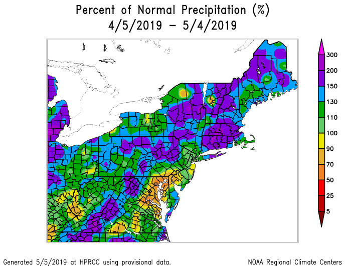
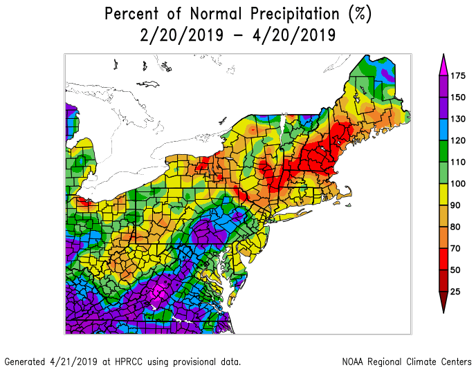
Precipitation has been well above normal across much of the Northeast over the past month. Image provided by the Northeast Regional Climate Center.
We’re starting Monday off with some clouds, and a few lingering showers across the Cape, but things will improve this afternoon as high pressure builds in. That big, bright thing that will appear in the sky this afternoon is called “the sun”. We haven’t seen much of it lately, but we will today. Oh don’t worry, it won’t hang around too long. Clouds come right back on Tuesday ahead of a cold front, with more showers in the afternoon, maybe even a thunderstorm. The difference between Tuesday and the recent rain? It’ll be warm ahead of the front. Instead of east to northeast winds off the chilly Atlantic, we’ll have warmer west to southwest winds. Temperatures could top 70 in many locations.
Tuesday looks like it could be mild before the cold front brings in more rain. Image provided by Weathermodels.com
That cold front will stall out south of New England, but probably just far enough offshore to allow for some clearing on Wednesday as high pressure tries to build in. Another storm will start to approach on Thursday, but with the front stalled out to the south, we’ll be chilly once again as more showers move in. Friday looks like a cool and wet day, though it could get warmer at least south of Boston as the front tries to move in. Everything moves offshore for the weekend, with drier weather returning, though we could see another system start to move in by late Sunday.
Monday: A cloudy start, but sunshine gradually develops from west to east. High 58-65, a little cooler along the coast.
Monday night: Becoming mostly clear. Low 39-46.
Tuesday: Sunshine in the morning, then clouds return. Showers, maybe a thunderstorm late afternoon, breezy at times. High 67-74, cooler along the South Coast.
Tuesday night: Showers, possibly a thunderstorm, during the evening, then skies clear out across much of the region overnight, though clouds may linger across the South Coast. Low 41-48.
Wednesday: A mix of sun and clouds, with cloudiness mostly likely along the South Coast, breezy. High 58-65.
Thursday: Some early sunshine, otherwise mostly cloudy with a few showers possible during the afternoon, more likely at night. High 50-57.
Friday: Cloudy with rain likely, ending at night. High 49-56, possibly warmer south of Boston.
Saturday: Becoming partly to mostly sunny and breezy. High 58-65.
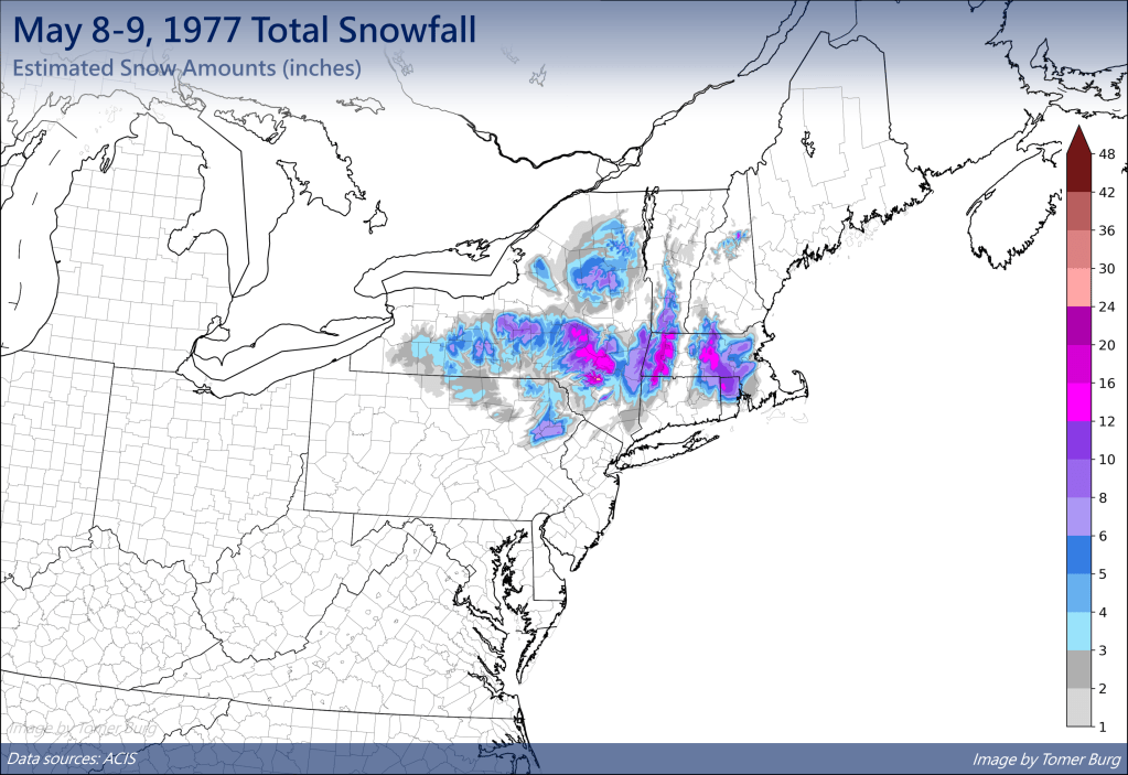
Can you believe that we’re at the end of April already? That means it’s almost to the time of year where it’s safe to push your snowbrush away! We’ve had accumulating snow into early/mid-May before, so it’s not quite that time yet, but we’re getting close.
We’ve had heavy snow into early May, so don’t put those snowbrushes away just yet. Image provided by Tomer Burg.
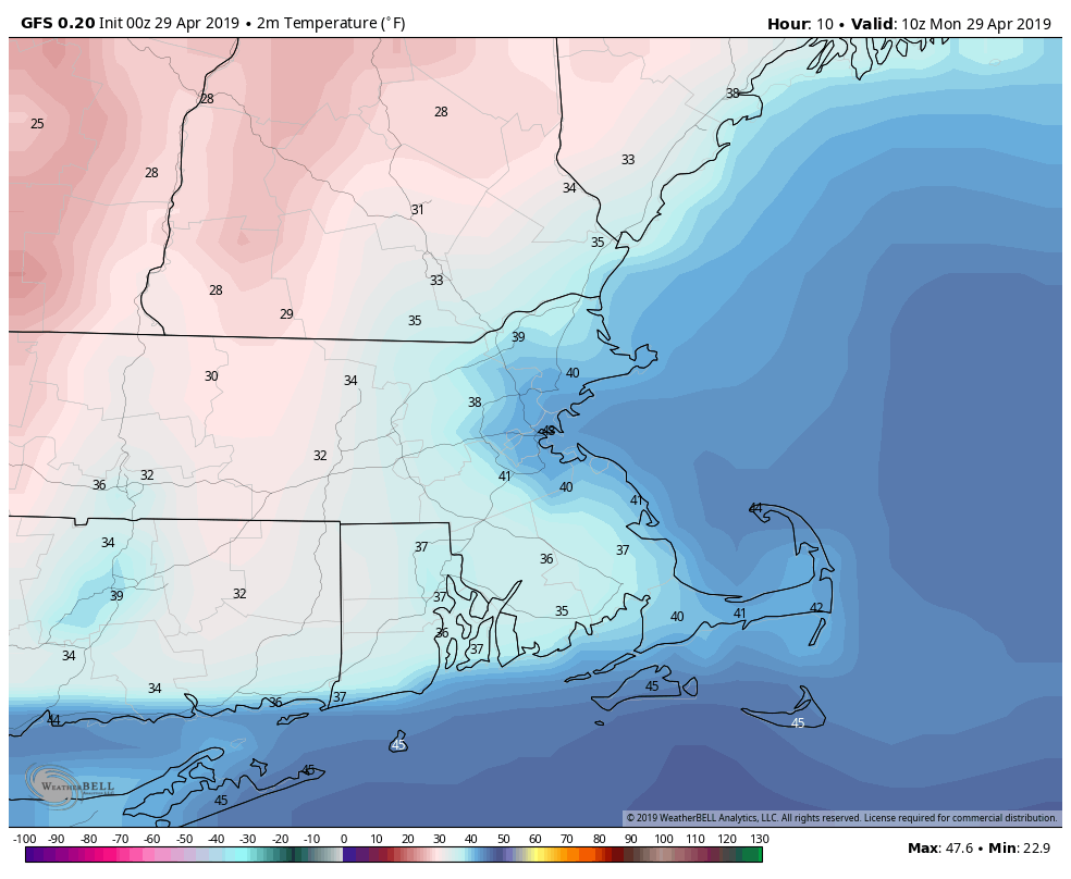
We’ll start the week on a chilly note as high pressure builds in from the north, so you may need a heavier jacket as you venture out Monday morning. You may even need to scrape your windshield if you’re out earlier enough, as there will likely be some patchy frost out there as well. Clouds will start to stream in during the afternoon as the high moves out and our next system approaches from the west.
Temperatures may drop into the 30s across much of the area before daybreak today. Image provided by WeatherBell.
Rain will develop late Monday night as a weak system moves toward the area. The rain won’t be heavy and should be done by early afternoon, with some clearing possible late in the day. A cold front trailing the system will stall out just south of New England, and then remain there for much of the week.
The latter half of the week looks to be cool and damp. Waves of low pressure will ride along that front, bringing in rainfall at times. We won’t be raining the entire time, but it will be mainly cloudy with some sunny breaks. With the front to our south, we’ll stay on the cool side around here, with daytime temperatures generally in the 50s to lower 60s., which is a little below normal for early May. Saturday may turn out to be a decent day with some sunshine and and milder temperature. However, a stronger storm will moves toward the area on Sunday, with some steadier and heavier rain more likely.
So close, yet so far away. Thursday afternoon could see temperatures get into the 80s in New York City, while we could be stuck in the 40s and lower 50s in the afternoon. Image provided by Weathermodels.com
Monday: Sunny and cool in the morning, clouds stream in during the afternoon. High 54-61.
Monday night: Cloudy with showers developing. Low 37-44.
Tuesday: Mostly cloudy with showers ending by midday. High 49-56.
Tuesday night: Partly to mostly cloudy. Low 34-41.
Wednesday: Plenty of clouds with a few sunny breaks. Showers are possible late in the day and at night. High 50-57.
Thursday: More clouds than sunshine with showers possible in the morning and some patchy drizzle in the afternoon. High 48-55, warmer as you head farther south and west
Friday: Cloudy with a chance for more showers. High 50-57, possibly warmer south of the Mass Pike.
Saturday: Partly sunny. High 66-73.
Sunday: Cloudy with a chance of rain, possibly heavy. High 53-60.
Did you enjoy the sunshine and warm temperatures at the end of the past week? Good, because you probably won’t get much of that this week. This week looks rather wet at times. The whole week won’t be wet, but there will be a few days that are quite damp.
We start the week off with some fog this morning, especially along the south coast, since we have plenty of moisture in the air. A weak system will pass offshore today, and it will bring in a period of rain and showers, mainly across eastern New England. Some of this rain will be locally heavy, and thanks to northeast winds off the still-cool Atlantic, temperatures will be cooler than the past few days. The rain may linger into Tuesday morning before the system pulls away. Some sunny breaks may develop in the afternoon, but they won’t last long. Another cold front quickly approaches for Tuesday night into Wednesday morning with more showers.
Some of the rain today into early Tuesday could be heavy across eastern New England. Keep that umbrella handy. Image provided by WeatherBell.
High pressure builds in for later Wednesday into Thursday with sunshine and seasonable temperatures, but this too will only be temporary. The next system approaches on Friday, with, you guessed it, more rain, but it’ll be generally light. High pressure returns for Saturday with some sunshine, but again, not for long. Yet another system will move in for Sunday with another round of rain, and there’s a chance that this could be heavy too. We’ll keep an eye on that as the week goes along, but don;t go cancelling any plans for next weekend just yet.
Rainfall has actually well below normal over the last couple of months across much of the Northeast, so we really need this week’s rain. Image provided by the Northeast Regional Climate Center
Monday: Fog burns off early, then a few sunny breaks are possible before clouds return, with rain likely during the afternoon. Becoming breezy during the afternoon, especially along the coast. High 57-64, but turning cooler in the afternoon along the coast.
Monday night: Periods of rain and showers, possible heavy at times. Low 45-52.
Tuesday: A few lingering showers in the morning, otherwise cloudy with some sunny breaks in the afternoon. High 51-58, except 59-66 north and west of I-495.
Tuesday night: Cloudy with scattered showers. Low 41-48.
Wednesday: Showers ending early, then skies become partly to mostly sunny and breezy in the afternoon. High 60-67.
Thursday: Mostly sunny for much of the day, clouds start to filter back in during the afternoon. High 59-66.
Friday: Mostly cloudy with showers likely. High 54-61.
Saturday: Sunshine to start, clouds come back in the afternoon, breezy. High 54-61.
Sunday: Mostly cloudy with a chance of rain. High 55-62.
We’ve reached Patriots Day, which is the “unofficial” end of winter in many years. We’ve got the Marathon, the Red Sox 11:05am game, and usually, but not always, some decent weather.
The morning may be quite wet, but things should improve for the Marathon and the Red Sox game. Loop provided by WeatherModels.com
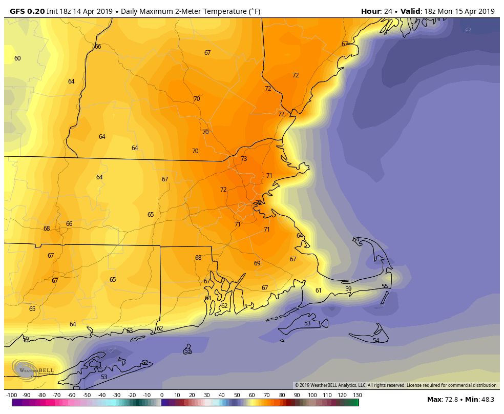
The week starts off on a damp but mild note as warm front lifts northward during the morning. Showers and maybe even some thunderstorms are likely. This system has been producing severe weather across much of the eastern half of the nation for the past few days, but we’re not expecting any severe weather here. Some downpours, gusty winds, and a little lightning are expected, but nothing severe. The rain should end around 9-10am, which is perfect timing for both the Marathon and the Red Sox game. Some sunny breaks could develop in the afternoon, which may allow temperatures to get up to 70 once again. The mild weather comes to an end late this afternoon as a cold front moves through, likely with a few more showers.
Temperatures could get close to or over 70 this afternoon if we can get some sunshine. Image provided by WeatherBell.
Windy and cooler weather moves in behind the front for Monday night into Tuesday as high pressure builds in. Wednesday looks dry as well, and slightly milder, but still cooler than what we enjoyed this past weekend. Thursday will see some clouds move in ahead of a warm front, along with some showers, but we’ll stay on the cool side until the front actually moves through, which will likely be sometime on Friday.
This brings us to the end of the week and the weekend. Another strong storm will be moving through the Plains states and into the Midwest. More severe weather is likely, but with this storm only making slow progress eastward, we’ll also be dealing with it for a couple of days. We’ll have some showers around on Friday as the milder air moves in, but a period of heavy rain is possible later Friday into Saturday. Don’t go cancelling any outdoor plans yet, but we’ve got the potential for quite a bit of rain. The rain may linger into Sunday before a cold front finally moves across the region.
Heavy rain is possible across the region on Saturday. Image provided by Pivotal Weather.
Monday: Rain, maybe a thunderstorm this morning, then some sunny breaks in the afternoon before another round of showers moves through late afternoon. High 64-71.
Monday night: Clearing, windy, and cooler. Low 34-41.
Tuesday: Sunshine and a few clouds, breezy. High 53-60.
Tuesday night: Clear skies. Low 33-40.
Wednesday: Mostly sunny, though some high clouds may start to stream in late in the day. High 54-61.
Thursday: Partly to mostly cloudy. High 48-55.
Friday: Mostly cloudy and breezy with a few showers possible, becoming a steadier rain at night. High 61-68.
Saturday: Cloudy and breezy with rain likely, possibly heavy. High 61-68.
Sunday: More clouds than sunshine, a few lingering showers possible. High 64-71.
The Red Sox finally return to Fenway this week. Unfortunately, the weather for the next few days is going to be about as good as the Sox season has been thus far.
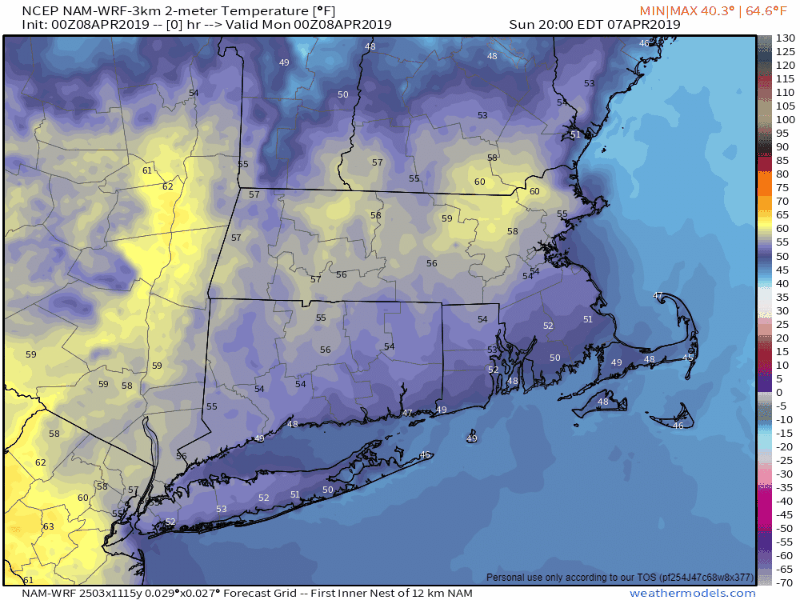
The week starts off with a backdoor front dropping south of the region as low pressure moves this way from the Midwest. That will result in some rain today, along with chilly northeast winds, and some drizzle on fog. as you head north, up into portions of Maine and central New Hampshire, we might be talking about some snow, as well as rain. In other words, it’ll be typical weather for April in New England.
The High-Resolution NAM model clearly shows the impact that the backdoor front has on temperatures across the region today and tonight. Loop provided by Weathermodels.com
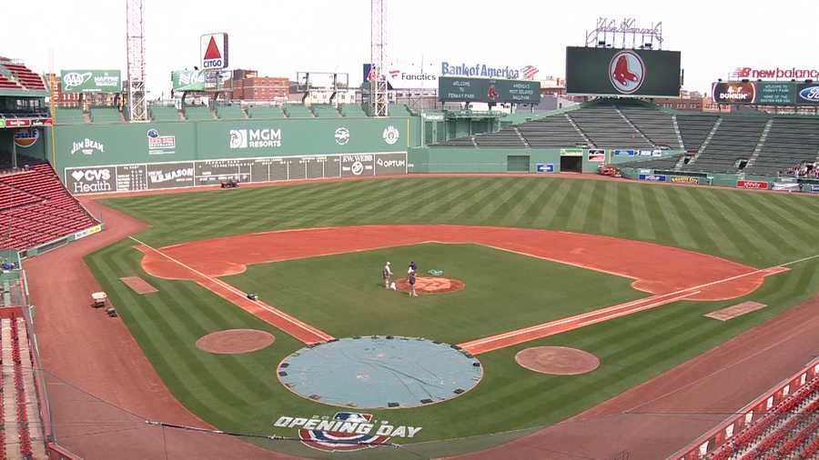
That front will stall out south of New England tonight, and another wave of low pressure will ride along it on Tuesday. This will bring another round of showers in for the late afternoon and evening hours. Most of Opening Day for the Sox should be dry (except for some drizzle at times), but the longer the game goes, the better the chance for some rain moving in and causing problems.
Opening Day at Fenway looks cloudy, chilly, drizzly, and just plain miserable. Hopefully the on-field product won’t be as bad. Image provided by WCVB.
We’ll start to improve on Wednesday as high pressure starts to build in, but an upper-level low will move across the region, so we’ll still have some clouds and maybe a few showers to deal with. Sunshine finally returns on Thursday, but temperatures will still be on the cool side. Another system brings in some showers on Friday, then high pressure returns next weekend with dry and milder weather, but we could see some showers moving in by late Sunday.
This brings us to next Monday. A week from today is Patriots Day, also known as Marathon Monday. This is the unofficial start of Spring in New England. Last year, Patriots Day featured heavy rain and cool conditions. This resulted in the Red Sox traditional 11:05am game being postponed for the first time since 1984. So, things will be much better this year, right? Right now, it’s not looking that way. There’s still plenty of time for things to change, but right now, the models are showing the potential for heavy rain again, maybe even some snow in parts of the region. We’ll keep our eyes on this through the week.
One model is showing midday temperatures on Marathon Monday in the upper 30s to near 40. That’s rather chilly for Mid-April. Image provided by WeatherBell.
Monday: Cloudy and cool with periods of rain and showers, along with some fog and drizzle. High 43-50 north of the Mass Pike, 51-58 south of the Pike.
Monday night: cloudy with patchy fog and drizzle. Low 34-41.
Tuesday: More fog and drizzle, with showers likely late in the day. High 41-48.
Tuesday night: Mostly cloudy with showers ending. Low 31-38.
Wednesday: Intervals of clouds and sunshine, chance for a shower or two. High 43-50.
Thursday: Partly to mostly sunny. Clouds return late in the day. High 50-57.
Friday: Cloudy with a chance for some showers. High 53-60.
Saturday: Sunshine and a few clouds. High 60-67.
Sunday: Some early sun, then becoming cloudy with a chance of showers late in the day. High 52-59.
Finally, as you probably know by now, we’re big hockey fans here at Storm HQ. This is a big week in the hockey world. The NCAA Frozen Four takes place Thursday and Saturday, and the NHL playoffs start Wednesday. In the Frozen Four, we’re rooting for Providence to beat the defending champions from Minnesota-Duluth and for Denver to beat UMass by double digits. In the NHL playoffs, the picture above says it all for the 1st round at least. Go Bruins!
Today is April Fool’s Day, but there’s no jokes in our forecast. Sure, there’s sarcasm, because that’s how we roll, but we’d never try and fool you. Having said that, we can tell you that there’s a little bit of everything in this week’s forecast, because, well, that’s called Spring in New England.
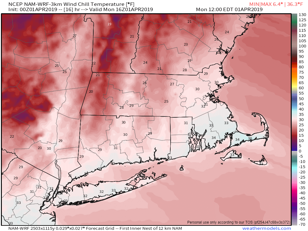
The week starts off on a sunny but chilly note as high pressure builds into the region. Even with sunshine, wind chills will be in the 30s this afternoon. The chill won’t last too long as temperatures will start to moderate on Tuesday as high pressure moves offshore. Clouds will start to move in late in the day on Tuesday as a storm system starts to move up the East Coast.
Heading out at lunchtime? Wind chills will only be in the upper 20s and 30s around midday. Image provided by Weathermodels.com
Low pressure will pass offshore to the south and east of the region, but should be close enough to bring in some rain for Wednesday morning. Some wet snowflakes could even be mixed in before daybreak, mainly from the hills of Worcester County into southern New Hampshire. The rain will light for much of us, but some heavier rain is possible across parts of southeastern Massachusetts and Cape Cod, where gusty winds are also expected. The system will be a fast mover, with clearing expected to start Wednesday afternoon.
At least one model shows the potential for a decent amount of rain on Wednesday, especially from Boston southward. Image provided by WeatherBell.
High pressure returns for Thursday with dry conditions. However, the dry weather won’t last (does it ever really?) as the next system moves in for Friday. Again, we’re looking at rain, but don’t be surprised if you see some snowflakes at the start across parts of southern New Hampshire and maybe even the Merrimack Valley. High pressure builds back in for next weekend.
Monday: Sunshine, and lots of it, but also breezy. High 39-46.
Monday night: Clear to partly cloudy. Low 23-30.
Tuesday: A sunny start, clouds thicken up in the afternoon. High 44-51.
Tuesday night: Cloudy with showers developing towards daybreak. Low 32-39.
Wednesday: Rain during the morning, especially south of Boston, then skies clear out in the afternoon, breezy. High 52-59.
Thursday: A mix of sun and clouds, breezy. High 46-53.
Friday: Cloudy with showers likely. High 42-49.
Saturday: Showers ending early, then skies gradually clear out in the afternoon. High 54-61.
We’re into the last week of March and we have our surest sign yet that winter is just about over. Opening Day for the defending World Champion Red Sox (we really love saying that) is Thursday. Granted, it’s in Seattle, and we have to wait another week and a half before they come back to Fenway, but we’re talking about baseball! Summer will be here before you know it.
Baseball is back! That means winter is nearly over. Image provided by Sportslogos.net
The first half of the week will actually be fairly quiet. High pressure builds in today and Tuesday behind a departing cold front, with dry but chilly conditions. As the high moves off to the east, temperatures will start to moderate for Wednesday and Thursday.
On Thursday in Seattle, when the World Champion Red Sox take the field for a 4:10pm PDT first pitch, some showers are possible with temperatures in the middle to upper 50s. Don’t worry about the showers though, as Safeco Field T-Mobile Park has a retractable roof, so there shouldn’t be any weather-related issues. As for bullpen issues, well, that’s for other blogs to discuss, but after last season, our mantra for now is “In Alex We Trust”. After all, they are the defending World Champions (we really love saying that).
Getting back to the weather, things start to get complicated around here for Friday and the weekend. You may have heard some forecasts that show highs in the 60s and 70s around here for Friday, Saturday, and possibly Sunday. Sure, that would be great and it’s very possible, at least according to a couple of models. That doesn’t mean it’s going to happen though.
Several models think that Saturday could end up being a spectacular late March day. Do we agree with the models? Read on to find out. Image provided by Weathermodels.com
A cold front may bring in some showers Thursday night into early Friday. Most of the models show this front stalling out across Northern New England, and remaining there for Friday and Saturday. This would allow milder air to move in, with Friday seeing temperatures in the 60s, and Saturday possibly topping 70 in many areas. The models finally bring that front through on Sunday, with mild temperatures for one more day, though Sunday could end up a rainy day before the front snaps us back to reality. Some models actually have the rain changing to snow Sunday night before ending Monday morning. How’s that for a reality check?
The same model that has highs near 70 on Saturday (and Sunday), is forecasting 1-2″ of snow Sunday night and Monday morning around here. Spring is never fun for meteorologists. Image provided by Pivotal Weather.
So, if most of the models have it mild, why are we saying it might not happen? Because the models aren’t perfect, and we’ve seen this situation plenty of times in the past during the Spring, especially early Spring, and it doesn’t always work out the way the models show. The ocean is still very cold just to our east, with water temperatures in the upper 30s and 40s. There’s also plenty of snowcover up north. So, if you’ve got high pressure to the north, sitting over that cold air, and a front dropping southward, it’s got a lot of colder air to work with behind it. The front on Friday could very easily stall out just south of New England, and not somewhere across northern New England. If that happens, you can kiss those 60s and 70s goodbye. We’ll be looking at clouds, drizzle, and winds off the Atlantic keeping temperatures in the 40s, maybe even cooler.
The GFS Ensemble shows a wide range in potential forecast highs for Friday and beyond. We’ll explain what this image shows in the next paragraph. Image provided by WeatherBell.
The image above shows the forecast highs and lows for Bedford, Massachusetts for the next 15 days, based on the 20 members of the GFS Ensemble. The top horizontal line on high temperatures each day is the highest maximum temperature forecast for highest 10% of the members (2 out of 20). The horizontal line at the bottom of each day is the maximum forecast by lowest 10% of the members. The shaded area in the middle is the range based where 30-70% of the members are forecasting. The dot in the middle is the mean of all 20 members. Using this example for Saturday, the Ensemble has forecast range of 39 to 67 for high temperatures in Bedford. Most of the members come in between 47 and 58, with a mean of 53. With this in mind, we’re going to follow this thinking for now for Friday through Sunday, with highs mainly in the 50s to lower 60s. Keep in mind, temperatures could end up 10-15 degrees warmer or cooler than what we’re currently showing, depending on which scenario actually develops.
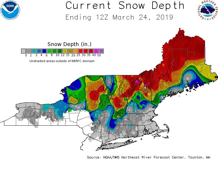
There is still a lot of snow on the ground in Northern New England. This may cause flood problems later in the Spring, but for now, it may help ruin a potential warm spell later in the week. Image provided by the Northeast River Forecast Center.
Monday: More clouds than sunshine. High 42-49.
Monday night: Clearing. Low 21-28.
Tuesday: Sunshine, and lots of it. High 36-43.
Tuesday night: Clear skies. Low 18-25.
Wednesday: Sunshine and just a few clouds. High 41-48.
Thursday: Morning sunshine, clouds start to move in during the afternoon. Showers possible at night. Breezy and milder. High 48-55, coolest along the south coast.
Friday: Plenty of clouds with some sunny breaks, especially during the afternoon. More showers and drizzle are possible at night. High 55-62.
Saturday: Mostly cloudy and breezy. High 58-65, cooler along the south coast.
Sunday: Cloudy and breezy with rain likely, possibly changing to snow at night. High 53-60.
Meteorological Spring began on March 1. Astronomical spring begins with the Vernal Equinox this Wednesday, March 20, at 5:58pm EDT. Aside from our brief taste a few days ago, when will it really feel like Spring? Probably not this week.
Astronomical Spring starts late Wednesday afternoon. Image provided by AccuWeather,
Once again, we’ve got another fairly quiet week coming up across the region, thanks to high pressure. As it builds it, we’ll have dry and chilly weather for the next few days. Chilly is of course a relative term, as “chilly” in mid-March is a lot different than “chilly” in mid-January. We’ll moderate a bit for the first day of Spring on Wednesday as the high moves offshore. It might even be a decent day for some ice cream, since Dairy Queen is offering a free small vanilla cone to celebrate the start of Spring. Then again, is there a bad day for ice cream?
After a very wet fall and winter, precipitation is below to well below normal over the past 30 days. The next 7 days aren’t going to reverse that trend. Image provided by the Northeast Regional Climate Center.
By Thursday we’ll have a cold front approaching the area. It will bring in some showers. Colder air moves in on Friday, and with an upper-level disturbance moving through, some rain or snow showers are possible. We’re not looking at any accumulation around here, but it’s just a reminder that even though it’ll be “Spring”, Mother Nature follows her own calendar.
High pressure returns on Saturday with much colder conditions. It’ll feel like winter, with highs in the upper 30s to middle 40s. The high moves offshore, and we’ll quickly warm up again on Sunday.
At least one model shows the potential for a nice warmup next Sunday after a rather cool Saturday. Image provided by Weathermodels.com
Monday: Sunshine and afternoon clouds. High 37-44.
Monday night: Partly cloudy. Low 21-28.
Tuesday: Partly sunny. High 37-44.
Tuesday night: Clear skies. Low 22-29.
Wednesday: Mostly sunny for much of the day, clouds start to stream in by late afternoon. High 43-50.
Thursday: Plenty of clouds and breezy with scattered showers. High 44-51.
Friday: Some early sun, then clouding up again with a few rain or snow showers possible, breezy. High 41-48.
Saturday: Sunshine. Lots of it. Blustery. High 37-44.
Sunday: Plenty of sunshine again, with just a few clouds around. High 53-60, cooler along the South Coast.
There are some indications that we could be looking at a storm around here next Tuesday or Wednesday. It’s obviously way too early for any specifics, and we’re not expecting this to be a snowstorm, but it might not be just rain either. Late-season snowstorms aren’t unheard of, as we’ve had big storms well into April and even early May before. If the models continue down this path, well obviously have more info in our weekly outlook next week. Basically, we’re just telling you now that you shouldn’t take the ice scraper out of the car and put away your winter clothing just yet.
We’ve actually got a fairly quiet week coming up across the region, and we should melt quite a bit of the snow that’s out there.
High pressure builds into the region today as yesterday’s storm continues to move into southeastern Canada. We’ll have a mild day, but cooler air will filter in, with Tuesday and Wednesday turning out much cooler than today. Still we’ll have temperatures above freezing during the daylight hours, so the snowpack that’s been in place for over a week now will gradually start to dwindle as the strong March sun also goes to work on it.
As we get into the middle of March, average high temperatures are in the middle 40s. Image provided by WeatherBell.
By late week, the high slides offshore, allowing milder air to move back in. By Friday, another storms system heads into the Great Lakes. This one looks like it will be mainly rain around here. In fact, we should be quite mild, with temperatures well into the 50s on Friday.
Friday could be a very mild day across the region. Image provided by Weathermodels.com
We’ll cool down a little on Saturday behind the system, then high pressure builds in next Sunday, making for a chilly St. Patrick’s Day.
Monday: Sunshine and some afternoon clouds, breezy. High 41-48.
Monday night: Clear to partly cloudy. Low 24-31.
Tuesday: Partly to mostly sunny, still breezy. High 34-41.
Tuesday night: Clear skies. Low 18-25.
Wednesday: Sunshine filtered by afternoon high clouds. High 39-46.
Thursday: Partly sunny, breezy, and milder. High 46-53.
Friday: Cloudy and mild with showers likely. High 54-61.
Saturday: Partly to mostly sunny and breezy. High 44-51.
The first full week of March is shaping up to be a wintry one, mainly in the temperature department, but a little in the precipitation department as well.
The snow will be ending across the region this morning as our storm system pulls away, with some clearing this afternoon. Temperatures may even get a tad mild, allowing for some melting to take place. However, we’re going to drop back below freezing tonight, so anything that melted with ice back up. If you’re heading out this evening, watch out for slippery conditions on untreated surfaces.
Temperatures could get into the middle to upper 30s this afternoon, allowing some of the fresh snow to melt. Image provided by WeatherBell.
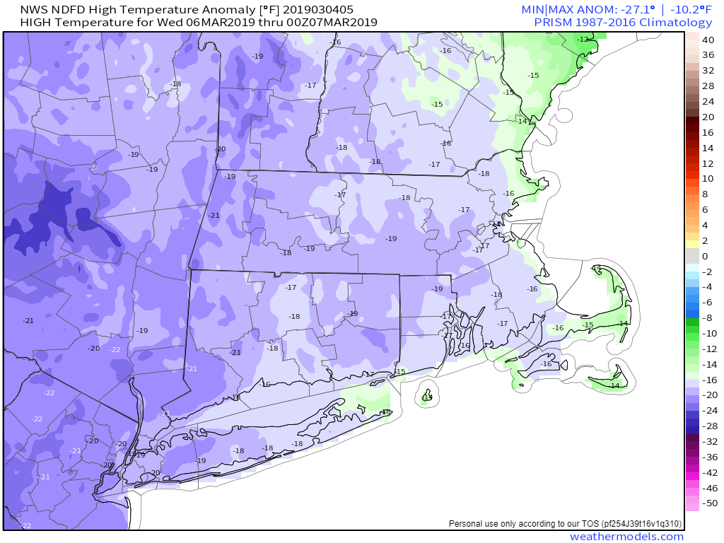
After that, a rather cold airmass will settle into the region for Tuesday through Thursday. While temperatures won’t be as extreme as in the Plains states, we’re still looking at temperatures that are 10-20 degrees below normal, especially Wednesday and Thursday. A couple of upper-level disturbances will also be moving through the region, which may produce a few snow showers at times, especially Wednesday and Thursday.
Temperatures will be 10-20 degrees below normal during the middle of the week. Image provided by Weathermodels.com
By Friday, high pressure will move offshore and temperatures will start to moderate. That just means it won’t be quite as cold, but temperatures will still be below normal. The weekend is where things get complicated.
It looks like we’re going to have 2 systems impact the area, a weak one on Saturday, and a stronger one on Saturday. Given that these are both several days away, nothing is set in stone at this point. The first system passes south of New England on Saturday. There is at least one model that has it pass too far south to have any impact on us, but most bring it close enough to spread in some light precipitation. Right now, it looks likely mainly some light snow, but it could be some rain as well, especially along the south coast.
The stronger storm comes in on Sunday. This one looks like it will produce some rain across the area. However, some models are showing temperatures below freezing at the start, which means we’d be looking at yet another situation where we have snow to sleet or freezing rain inland and rain along the coast. Again, this is a week away, so trying to nail down details at this point is a futile exercise. Just be aware that next Sunday could be messy, especially north and west of Boston.
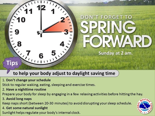
Daylight Saving Time starts at 2am Sunday. Sunset next Sunday evening will be at approximately 6:45pm. Image provided by the National Weather Service.
Monday: Snow (rain on the Cape) ending early, some sunny breaks develop in the afternoon. High 33-40.
Monday night: Becoming mostly clear. Low 9-16.
Tuesday: Morning sunshine, afternoon clouds, slight chance for a snow flurry. High 24-31.
Tuesday night: Clear to partly cloudy. Low 10-17.
Wednesday: A sunny start, then clouding up again, breezy. A snow shower is possible. High 19-26.
Thursday: Intervals of clouds and sunshine, with a few afternoon snow showers possible. High 20-27.
Friday: Plenty of clouds. Light snow or rain developing at night. High 28-35.
Saturday: Cloudy with some snow or rain showers possible in the morning. High 31-38.
Sunday: Cloudy with a chance of rain, possibly some snow or a wintry mix across the interior. High 34-41.