Weekly Outlook: May 29 – June 4, 2023

As we reach the beginning of meteorological summer, warm and dry weather is expected once again.

Despite the heavy rain from a couple of weeks ago, rainfall is well below normal over the past couple of months across the region. Image provided by WeatherBell.

After a rather warm Sunday, a cold front moved through overnight, which will set up a much cooler day today. Temperatures will be as much as 15-25 degrees cooler today compared to Sunday, despite plenty of sunshine. Tuesday will also feature lots of sunshine, with temperatures beginning to rebound a little. High pressure then settles off to the south, with much warmer air return for Wednesday and especially Thursday and Friday, when temperatures could reach 90 in some areas once again. A cold front may produce a few showers or thunderstorms Friday night, then high pressure builds back in with much cooler air for Saturday. Temperatures will begin to moderate again by Sunday.

Temperatures could top 90 in many areas on Thursday and Friday, especially away from the coast. Image provided by Weathermodels.com.

Monday: Plenty of sunshine, breezy, and cooler. High 67-74, cooler near the coast.

Monday night: Clear skies. Low 42-49.

Tuesday: Sunny. High 69-76, cooler along the coast.

Tuesday night: Clear to partly cloudy, patchy fog possible near the South Coast. Low 43-50.

Wednesday: Sunny and milder. High 78-85, cooler along the South Coast.

Thursday: More sunshine, very warm. High 85-92, cooler along the coast.

Friday: A mix of sun and clouds, chance for a few showers and thunderstorms late in the day or at night. High 85-92, cooler along the coast.

Saturday: Partly sunny, breezy, cooler again. High 66-73, a little cooler near the coast.

Sunday: Mostly sunny. High 71-78, a little cooler near the coast.

Weekend Outlook: May 26-29, 2023

Memorial Day Weekend is the unofficial start, and the weather couldn’t be much better than what we’ll have.

One thing we won’t have much of this weekend is clouds. Loop provided by Pivotal Weather.

High pressure will build in north of the region, and slowly drift eastward over the next few days. We’ll start off the weekend with a rather cool night tonight, but temperatures will moderate over the next few days, with Sunday and Monday likely to see 80s in many areas away from the coast. For the most part, we’ll have sunshine each day, though some high-level haze and smoke may drift through at times. We also need to keep an eye on a low pressure area off the Southeast coast. While the high to our north should block its northward progress, some high clouds on the northern fringe of it could reach the South Coast toward Sunday and Monday, which would be the only blemish on the weekend forecast.

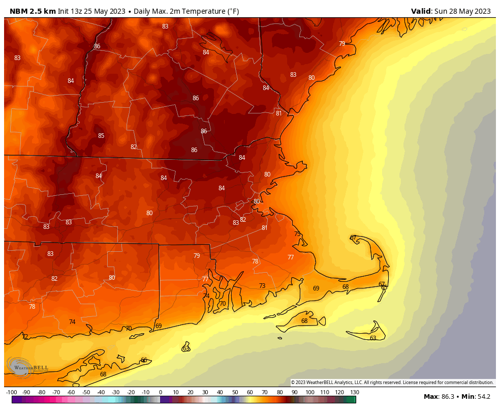
Sunday looks like the warmest day of the weekend, with widespread 80s away from the coast. Images provided by WeatherBell.

Thursday night: Clear and cool. Low 40-47.

Friday: Mostly sunny, milder. High 65-72, cooler along the coast.

Friday night: Clear skies. Low 43-50.

Saturday: Plenty of sunshine, warmer. High 72-79, cooler near the South Coast and Cape Cod.

Saturday night: Clear skies. Low 48-55.

Sunday: More sunshine, a little breezy. High 79-86, cooler near the South Coast and Cape Cod.

Sunday night: Low 53-60.

Memorial Day: Sunshine and possibly some high clouds, a little breezy at times. High 74-81, a little cooler near the coast.

Weekly Outlook: May 22-29, 2023

Dry weather is expected again for much of the upcoming week, but Memorial Day Weekend is uncertain right now.

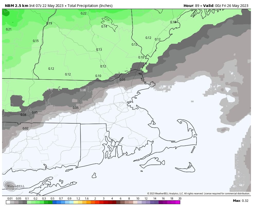
High pressure builds in north of the region today, resulting in onshore flow and cool temperatures, especially near the shoreline. As the high moves off to the east on Tuesday, temperatures will begin to moderate a bit, with an even warmer day likely on Wednesday. A cold front moves in late Wednesday and Wednesday night with some showers, mainly north of the Mass Pike, followed by much cooler weather on Thursday. High pressure continues to build in on Friday, with temperatures moderating again, which brings us to Memorial Day Weekend.

The cold front won’t produce a lot of rain on Wednesday, and most of it should be focused north of the Mass Pike. Image provided by WeatherBell.

Low pressure is expected to develop off the Southeast coast late this week and it will start to head northward. Yesterday, some of the models were showing the possibility of a cool and damp to wet Memorial Day weekend. Now, the models all show high pressure building in, keeping the low safely to the south. So, while our forecast is optimistic right now, there is still plenty of time for things to change.

The models all keep low pressure well to the south of New England for Memorial Day Weekend. Images provided by Pivotal Weather.

Monday: Sunshine, dimmed by haze and smoke from Canadian wildfires at times. High 62-69, coolest along the coast.

Monday night: Clear skies. Low 42-49.

Tuesday: More sunshine, but also more smoke and haze. High 64-71, coolest along the coast.

Tuesday night: Clear skies. Low 43-50.

Wednesday: Morning sun, increasing afternoon clouds, showers possible late in the day and into the evening, especially north of the Mass Pike. High 72-79, perhaps a little cooler right at the coast.

Thursday: A mix of sun and clouds, breezy, and cooler. High 58-65.

Friday: Partly sunny. High 64-71.

Saturday: A mix of sun and clouds. High 68-75.

Sunday: Partly sunny. High 69-76.

Memorial Day: Partly sunny. High 74-81.

Weekend Outlook: May 19-22, 2023

Some much-needed rain is coming this weekend, but don’t fret, it won’t ruin the entire weekend.

Record lows were set in numerous locations across the Northeast this morning, but temperatures will moderate over the next few days. Image provided by coolwx.com

Offshore high pressure remains in control for tonight and Friday, with dry and milder weather likely. We’ll still have smoke from wildfires in Canada dimming the sun at times on Friday, but overall it will be a nice day. Clouds will move in at night though as a pair of systems begin to head our way. A cold front will be moving in from the west, while a weak low pressure system moves up the East Coast. There are still some mixed signals with the coastal low for Saturday, which has a big impact on the forecast. Some models have that system send a batch of rain in for Saturday afternoon, others keep the rain either offshore, or confined to Cape Cod. We’re leaning towards the latter scenario at the moment. The cold front then moves through Saturday night with some showers along and ahead of it. High pressure then builds in for Sunday and Monday with dry and seasonably warm conditions, but we may still have some smoke drifting through, dimming the sun at times.

Many of the models are forecasting a bout of heavy rain this weekend, some keep the heavy rain to Cape Cod only. We’re leaning toward the latter. Images provided by Pivotal Weather.

Thursday night: Clear skies. Low 39-46.

Friday: Sunshine filtered through high-level smoke, clouds start to move in during the afternoon. High 66-73, a little cooler along the South Coast.

Friday night: Becoming mostly cloudy. Low 47-54.

Saturday: Cloudy and breezy with some showers likely. High 62-69.

Saturday night: Mostly cloudy with more showers, ending before daybreak. Low 52-59.

Sunday: Becoming partly sunny, smoke may filter the sun at times, breezy. High 69-76.

Sunday night: Partly cloudy. Low 47-54.

Monday: Plenty of sunshine, breezy. High 61-68, coolest near the coast.

Weekly Outlook: May 15-21, 2023

Temperatures will ride a roller coaster this week, but for the most part it should remain dry.

It’s chilly out there this morning. Image provided by Weathermodels.com

We’re starting the week off on a rather chilly note, but temperatures will quickly moderate today with high pressure in control. Tuesday looks to be fairly mild as well with some gusty winds ahead of a strong cold front. This front will be starved for moisture, so other than a few stray showers, you’ll notice the front when the winds shift. Wednesday looks to be a rather chilly day by mid-May standards with some gusty winds. As high pressure builds in Wednesday night, clear skies and light winds result in radiational cooling, with some frost likely. Temperatures remain on the cool side for Thursday, but should be a few degrees warmer than Wednesday. Warmer weather is expected on Friday with high pressure moving off to the east.

Tuesday looks like the pick of the week with partly sunny skies and warm temperatures. Image provided by WeatherBell.

Next weekend is looking a little uncertain at this point. Another cold front will likely move through, with a wave of low pressure riding up the coast along the front. However, the timing and placement of both the front and the wave, as well as the amount of moisture accompanying vary depending on which model you prefer. Given how dry it has been recently, and the trends in the models to overestimate rainfall several days in advance, we’re going to lean toward the dry side for now, with only a chance for some showers.

The models all have differing ideas for next weekend’s forecast. Images provided by Pivotal Weather.

Monday: Morning sunshine, some afternoon clouds, breezy. High 70-77, cooler across Cape Cod.

Monday night: Partly cloudy. Low 50-57.

Tuesday: Partly sunny, windy. High 75-82, cooler across Cape Cod.

Tuesday night: Partly to mostly cloudy, just a slight chance for a shower. Low 43-50.

Wednesday: Becoming mostly sunny, breezy, and cooler. High 58-65.

Thursday: Wall-to-wall sunshine. High 60-67.

Friday: Mostly sunny, breezy. High 66-73.

Saturday: Partly sunny, breezy, chance for a few showers. High 67-74.

Sunday: Intervals of clouds and sun, breezy. chance for some showers. High 65-72.

Weekend Outlook: May 12-15, 2023

Enjoy the warm weather for a few more days, because it will go away this weekend, at least temporarily.

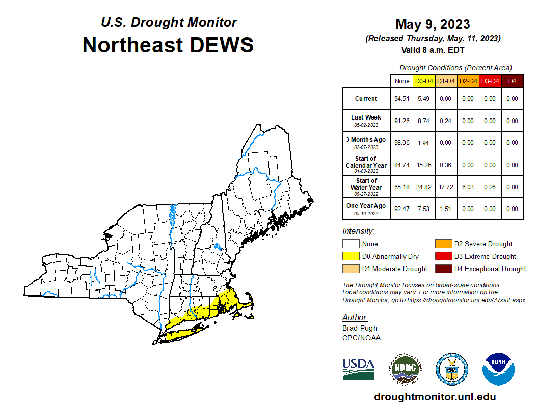
Drought isn’t a problem yet, but unless the pattern turns wetter soon, it could become an issue. Image provided by the National Drought Mitigation Center.

High pressure remains in control into Friday, however, a cold front will begin to approach the region. There will be just enough moisture in the air to make it feel a little humid, and this may help to trigger a few showers and thunderstorms during the afternoon and evening. The cold front moves through at night, possibly with another shower or two, and may slow down near the South Coast, keeping some clouds around into part of the day, otherwise, drier air will filter in, but it will remain warm. With high pressure building in, we’ll have clear skies and light winds for Saturday night, resulting in a cooler night due to radiational cooling. Sunday should feature plenty of sunshine, but it will be cooler than the past few days. After another chilly night Sunday night, temperatures will start to moderate on Monday.

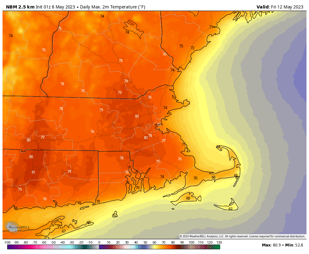
Much of the region could top 80 Friday afternoon. Image provided by WeatherBell.

Thursday night: Partly cloudy. Low 50-57.

Friday: A mix of sun and clouds, chance for a few showers or thunderstorms during the afternoon and evening. High 77-84, cooler across the South Coast, Cape, and Islands.

Friday night: Partly cloudy, slight chance for a shower. Low 55-62.

Saturday: Partly to mostly sunny. High 73-80.

Saturday night: Clear skies. Low 44-51.

Sunday: Sunshine and some high clouds, breezy, and cooler. High 62-69.

Sunday night: Clear to partly cloudy. Low 43-50.

Monday: A mix of sun and clouds, breezy. High 68-75.

Weekly Outlook: May 8-14, 2023

After a couple of cool and damp weeks, we’ve got most dry weather on the way for this week.

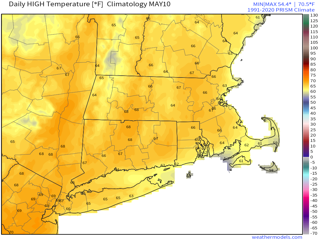
Average high temperatures in mid-May are in the middle 60s around here. Image provided by Weathermodels.com

We start the week off with a mostly sunny day today after clouds move offshore this morning, with mild temperatures once again. However, a backdoor cold front will move in for Tuesday with cooler temperatures, though we should remain dry. Temperatures will start to moderate on Wednesday, but even warmer weather is expected for Thursday and Friday. A weak frontal system may bring in a few showers late Friday and Friday night, with drier weather returning for next weekend.

Right now, Friday looks like the warmest day or the week, with some 80-degree readings possible. Image provided by WeatherBell.

Monday: A few clouds early, otherwise mostly sunny, breezy, and mild. High 67-74.

Monday night: Clear to partly cloudy. Low 40-47.

Tuesday: A mix of sun and clouds. High 59-66, coolest along the coast.

Tuesday night: Clear and cool. Low 37-44.

Wednesday: Plenty of sunshine. High 63-70.

Thursday: Partly to mostly sunny. High 72-79.

Friday: Partly sunny, breezy, chance for a few showers late in the day and at night. High 73-80.

Saturday: A mix of sun and clouds, breezy. High 72-79.

Sunday: Partly sunny. High 66-73.

Weekend Outlook: May 5-8, 2023

After a rather cool and damp week thus far, the weather will improve in time for the weekend.

The stubborn low pressure area that has been plaguing the region for much of the week will finally start to move out tonight, which slow improvement on Friday, and much better weather coming for the weekend. Not only will the rain end, but temperatures will get back to near to even above normal levels for early May.

For now, Monday looks like a fantastic day across the region. Image provided by Weathermodels.com

Thursday night: Cloudy with some drizzle and a few showers. Low 38-45.

Friday: Clouds and a few showers or drizzle gradually give way to some afternoon sunshine. High 52-59, coolest along the coast.

Friday night: Clearing. Low 40-47.

Saturday: Sunshine and some afternoon clouds. High 63-70.

Saturday night: Clear to partly cloudy. Low 44-51.

Sunday: Sunshine and a few clouds around. High 66-73.

Sunday night: Clear skies. Low 45-52.

Monday: Plenty of sunshine. High 68-75.

Weekly Outlook: May 1-7, 2023

Looks like another “blah” week coming up across the region.

Low pressure continues to pull away today with sunshine, breezy conditions, and mild temperatures. Another upper-level low then settles in, and controls our weather through Friday. As a result, we’ll have plenty of clouds, cool temperatures, and showers pretty much each day. Some of those showers may contain graupel or small hail, especially Tuesday and Wednesday. The upper low finally moves out at the end of the week, with drier and milder weather expected for the weekend.

Another week, another upper-level low to keep us cool and damp. Loop provided by Tropical Tidbits.

Monday: Becoming mostly sunny, breezy. High 59-66.

Monday night: Clear during the evening, then clouds increase. Low 41-48.

Tuesday: Mostly cloudy with some showers developing. High 52-59.

Tuesday night: Mostly cloudy with a few showers. Low 39-46.

Wednesday: Mostly cloudy with more showers developing. High 51-58.

Thursday: Mostly cloudy and cool, chance for a few showers. High 45-52.

Friday: Mostly cloudy, more showers possible. High 49-56.

Saturday: A mix of sun and clouds, slight chance for another shower. High 58-65.

Sunday: Partly to mostly sunny. High 63-70.

Weekend Outlook: April 28-May 1, 2023

Friday is looking like a really nice day, so you’d better enjoy it, because the rest of the weekend isn’t looking so great.

Drought conditions are beginning to develop across parts of the region. This weekend’s rain will help alleviate that. Image provided by the National Drought Mitigation Center.

The upper-level low pressure that’s been hanging around all week will finally move away and high pressure builds in tonight into Friday with drier and milder conditions. Friday like starts with some sunshine, but clouds will increase and thicken up during the afternoon and evening as low pressure begins to slowly move this way. The high will keep the rain shield from the low at bay for a while, but showers should eventually develop Saturday afternoon and continue into Sunday morning. Sunday may not be that bad of a day, but it certainly isn’t looking great. As the first system moves out, a second, more potent one, will begin to approach. Most of the rain from that system will hold off until Sunday night, so the bulk of Sunday will be just cloudy, but there will be enough moisture around for some drizzle and possibly a few showers. Rain is likely Sunday morning, ending by midday Monday, with some sunny breaks developing in the afternoon.

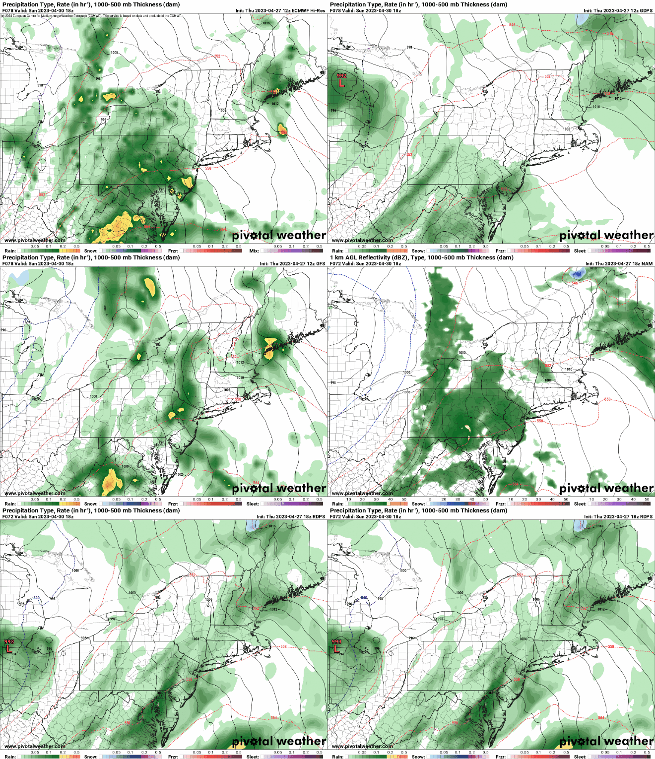
Sunday afternoon may end up dry, but not all the models agree on that. Images provided by Pivotal Weather.

Thursday night: Becoming clear to partly cloudy with areas of fog developing. Low 36-43.

Friday: Some morning sun, then clouds increase and thicken up. High 58-65, coolest along the coast.

Friday night: Mostly cloudy. Low 40-47.

Saturday: Cloudy and becoming breezy with showers developing during the afternoon. High 51-58.

Saturday night: Periods of rain and showers, breezy. Low 42-49 during the evening, temperatures may rise a bit after midnight.

Sunday: Rain tapers off in the morning, still some showers or drizzle around during the afternoon, still breezy. High 57-64.

Sunday night: Windy with rain redeveloping. Low 47-54.

Monday: Showers end in the morning, some clearing during the afternoon, breezy again. High 61-68.