Weekend Outlook: January 8-14, 2024

The first snowstorm of the season has pulled away, but we’re already looking ahead to two more potent storm systems later this week.

More snow than expected in the Merrimack Valley, otherwise, the storm behaved pretty much as expected. Image provided by the National Weather Service office in Norton, MA.

High pressure builds in today with dry and rather chilly conditions, thanks to the fresh snowcover. Tuesday starts off dry as well, but a strong storm system will head toward the Midwest, spreading clouds in. Temperatures will still be chilly, so when the precipitation moves in late in the day, it may start as snow or a wintry mix across the interior, with some accumulation possible. However, it won’t last too long. As the systems gets all wound up, strong southerly winds both at the surface and especially aloft will bring much warmer air into the region, changing everything to rain. Sustained winds of 15-25 mph with gusts of 40-50 mph are possible inland with the storm, but along the coast, we could be looking at sustained winds of 25-35 mph with gusts upwards of 50-60 mph or higher. This could lead to trees and power lines coming down with power outages a significant concern. Tides will be astronomically low, so the risk for coastal flooding is fairly low as well. The biggest problem aside from the winds will be heavy rain. Many areas could pick up 1-2 inches of rain or more. While this could lead to areas of flooding on its own, combine that with significant melting of the snow on the ground, and you’ve got a recipe for widespread flooding. We’ll see if that materializes over the next couple of days.
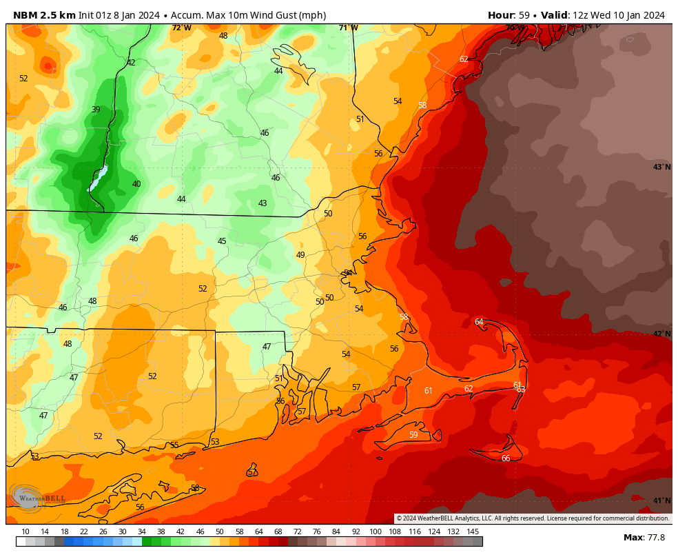
Strong southerly winds are expected across the region Tuesday night into Wednesday morning. Image provided by WeatherBell.

Rain ends early Wednesday, followed by windy and colder conditions during the day as the system moves across southeastern Canada. High pressure builds in for Thursday with diminishing winds. By Friday, another potent system moves into the Great Lakes, but things are a little more uncertain with this one. We could see a secondary low pressure system develop across the Mid-Atlantic states and head towards southern New England. If this does develop, then a colder scenario with at least some snow across the interior becomes more likely for Friday night into Saturday. If it doesn’t, then we’ll likely be looking at more rain, which could worsen flooding across the area. Another weak system could move through late Sunday with some snow showers possible.
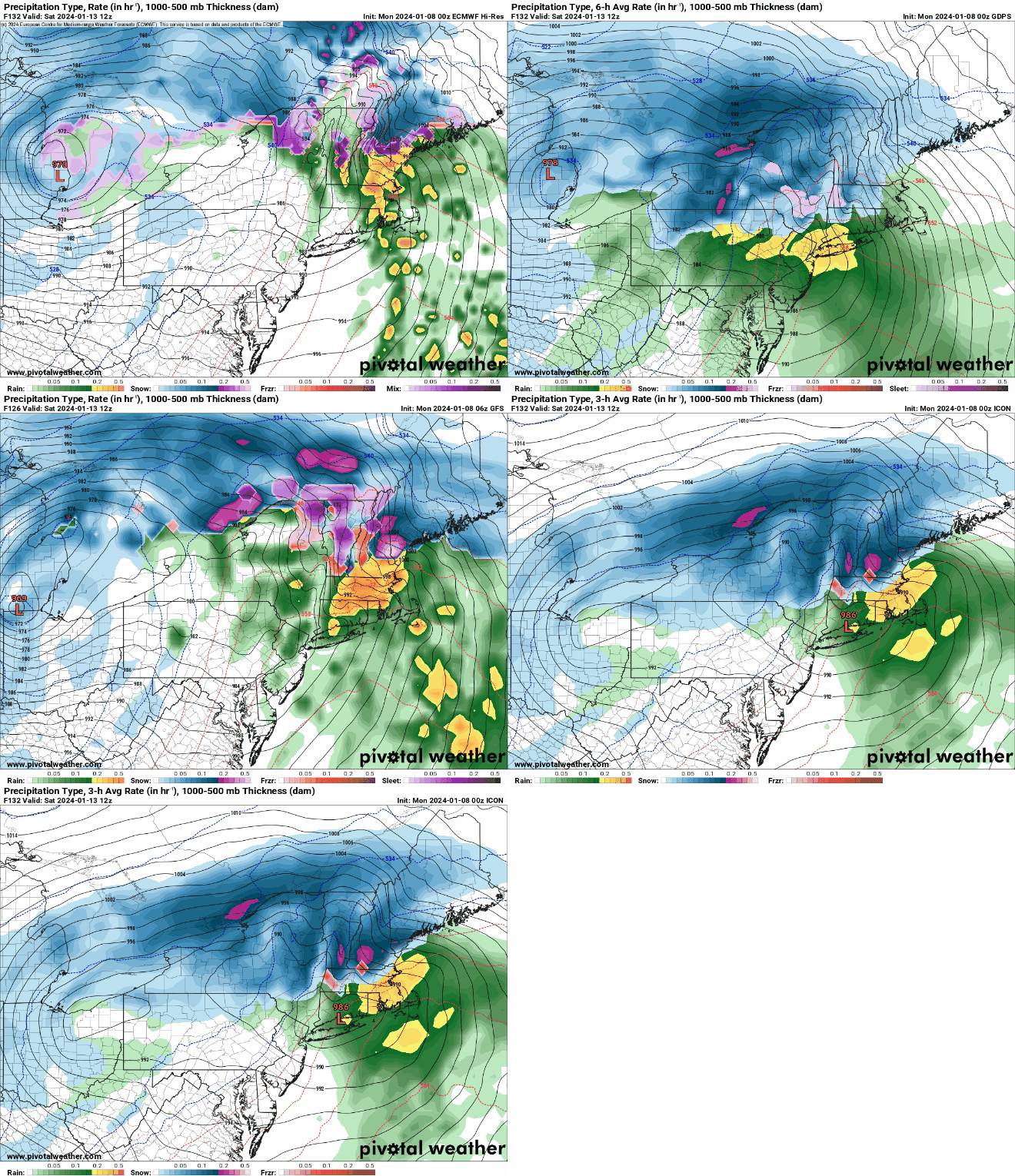
Will there be a secondary low on Saturday or not? Time will tell. Images provided by Pivotal Weather.

Monday: Plenty of sunshine, breezy during the morning. High 32-39.

Monday night: Clear skies, a few clouds move in late at night. Low 12-19.

Tuesday: Becoming mostly cloudy with rain developing late in the day from Boston southward, snow north and west. Winds start to pick up late in the day. High 34-41.

Tuesday night: Cloudy and very windy with everything becoming all rain, heavy at times. Low 31-38 during the evening, temperatures rise overnight.

Wednesday: Cloudy and windy with rain ending in the morning, skies start to clear out during the afternoon. High 50-57 early, temperatures start dropping in the afternoon.

Thursday: Mostly sunny, breezy, colder. High 38-45.

Friday: Morning sunshine followed by increasing afternoon clouds, rain developing at night, possibly starting as snow well inland. High 39-46.

Saturday: Mostly cloudy and windy with rain ending in the morning, some clearing possible late in the day. High 50-57.

Sunday: Partly sunny, windy, colder, a few late-day snow showers possible. High 34-41.

The First Snowstorm of the Year is On the Way

We’re less than 24 hours away from the first snowstorm of the year for most of the region, and while not a blockbuster, it will still have a sizable impact on the region.

Winter Storm Warnings and Winter Weather Advisories are in effect for much of the Northeast. Image provided by Pivotal Weather.

Low pressure will move across the Southeast and off the Mid-Atlantic coastline later today and tonight, passing south of New England on Sunday. Meanwhile, high pressure over Quebec will move into Atlantic Canada. While this high will provide cold air to start, due to its position and movement, combined with low pressure to the south, we’ve have gusty east winds across much of the region, possibly gusting to 30-40 mph or higher along the coast. With water temperatures still in the lower to middle 40s, this will mean that places close to the coastline will likely be rain or a mix to start. This includes parts of Cape Ann, the North Shore, Boston, and most of the South Shore, Cape Cod, and Southeastern Massachusetts. We’ll have a few flurries or sprinkles around this afternoon, but the steadier precipitation should move in between 6 and 9 pm. The precipitation may fall heavy at times overnight, but by daybreak winds will become more northeasterly, and eventually northerly towards midday. This will allow colder air to slide southward, changing the rain over to snow along the coast as well. This will also allow any untreated roads to rapidly ice up, so be careful if you will be out and about. The snow should eventually end during the evening, with winds rapidly diminishing overnight.

The High-Resolution Canadian Regional Model depicts the progression of the storm from later Saturday into Sunday evening. Loop provided by Tropical Tidbits.

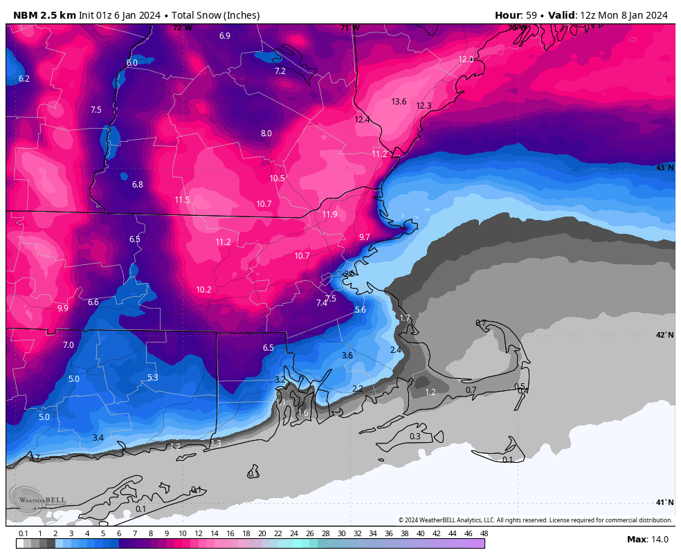
So, how much snow are we expecting? Well, if you read our initial forecast in the Weekend Outlook, we’re bumping numbers up a bit.

Cape Cod: Coating to 2 inches.
Southeastern Massachusetts: 2-5″
I-95 corridor (Boston to Providence) and immediate North Shore: 4-7″
MetroWest/Merrimack Valley/Interior Essex County/Southern NH: 5-10″ isolated totals of 12″+

The Blend of Models is still closest to our forecast. Image provided by WeatherBell.

We’ll clear out for Monday with chilly temperatures, due to the fresh snowcover. Another system follows for late Tuesday and Wednesday, and while this one may have some snow to start, it will end up much warmer with strong winds and heavy rain being the main concerns.

Weekend Outlook: January 5-8, 2024

Your luck has run out. Our first snowstorm of the winter is on the way this weekend.

A Winter Storm Watch is in effect north and west of I-95. Image provided by the National Weather Service office in Norton, MA

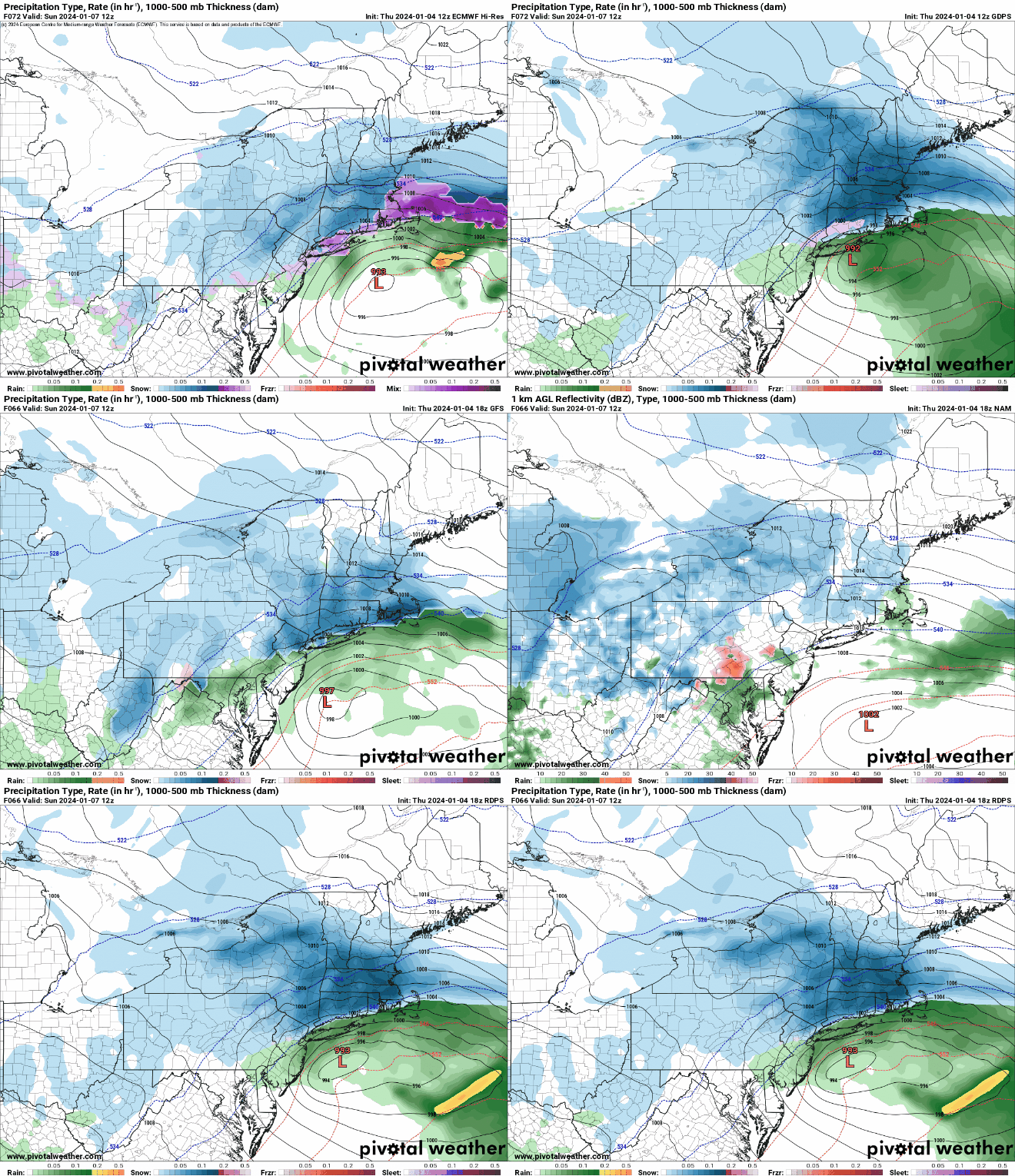
High pressure builds in for tonight and Friday, with clearing skies, breezy, and colder conditions. Clouds star to move back in Friday night and Saturday as low pressure moves across the Deep South and into the Southeast. It’ll move up the coast on Saturday, likely passing south of the region on Sunday, while high pressure in southern Quebec slides off to the east. There is still some uncertainty as what exactly will transpire, so some of the next paragraph is subject to change.

There is still plnety of disagreement among the models as to the evolution of the low pressure system. Images provided by Pivotal Weather.

While the high over southern Quebec will provide us with plenty of cold air to start, it’s not in the perfect position to provide the region with enough cold air to keep everything all snow, especially near the coastline. Winds will be out of the east, allowing milder air to move in off of the relatively mild Atlantic. (To get mostly snow, you want to high to be a little farther west, so you get northeast winds across our area). There is also still some uncertainty as to exact track the low pressure area takes and how close it gets to the coastline, which will also lead to some rain in spots, especially near the coast. We should see the snow developing Saturday evening, likely starting as a mix or even just plain rain along the coast from Boston southward since winds will be out of the east. Snow will continue through the night, but it may stay rain or a mix right along the immediate coastline for a while. By mid-morning Sunday, as the low passes by, winds will shift from the east into the north, allowing the cold air to push back in, changing everything to all snow, even across Cape Cod and the Islands before everything winds down by evening. The rain and milder temperatures keep accumulations lower near the coast, but inland, this will not be a blockbuster storm, as the snow , while falling for a while, will only be light to occasionally moderate for most of the time. So, how much are we looking at?

Cape Cod: Coating – 2″
I-95 corridor (Boston-Providence and points South+East): 2-5″, lowest along the coast
Areas North+ West of I-95: 4-8″ with isolated totals to 10″ possible.

The National Blend of Models is closest to our thinking for snow amounts. Image provided by WeatherBell.

Everything winds down Sunday night, and high pressure builds back in for Monday with sunshine and seasonably chilly conditions.

With fresh snowcover, Monday morning could be quite chilly across the region. Image provided by weathermodels.com

Thursday night: Clear skies, breezy. Low 17-24.

Friday: Plenty of sunshine, breezy during the morning. High 29-36.

Friday night: Partly cloudy. Low 20-27.

Saturday: Becoming mostly cloudy. High 32-39.

Saturday night: Snow developing, mixed with or changing to rain along the coast, becoming windy. Low 25-32 during the evening, temperatures hold steady or rise a bit overnight.

Sunday: Windy with snow likely, except rain or mix changing to snow along the coast by midday. High 32-39, temperatures rapidly drop along the coast in the afternoon.

Sunday night: Any lingering snow ends in the evening, some clearing late at night, winds rapidly diminish during the evening. Low 13-20.

Monday: Becoming mostly sunny. High 31-38.

Weekly Outlook: January 1-7, 2024

New year, new weather pattern? Well, sort of. We’ll still have above normal temperatures to start, but things could be changing significantly by next weekend.

Temperatures start the week above normal, but transition to near to below normal late in the week and next weekend. Loop provided by Weathermodels.com

We start the week (and year) off with some clouds thanks to a weak system passing offshore, but we’ll start to clear out this afternoon. High pressure builds in for tonight and Tuesday with seasonably cool and dry conditions. Wednesday remains dry as well, but we’ll see clouds start to filter in by late in the day. As we head into Thursday is when things start to change. Low pressure passes offshore while a cold front moves in from the north and west. Neither system will be particularly potent, but they will both bring in some rain or snow showers- the offshore system to coastal areas, especially southeastern Massachusetts, and the cold front produces some scattered rain or snow showers across the region. High pressure builds in behind these systems with cooler conditions for Friday. Another front tries to drop down from the north on Saturday, but stalls out nearby with just some cloudcover accompanying it. This brings us to Sunday, and you may want to sit down for this part (if you’re not sitting already).

A coating of snow is possible in some spots on Thursday. Image provided by WeatherBell.

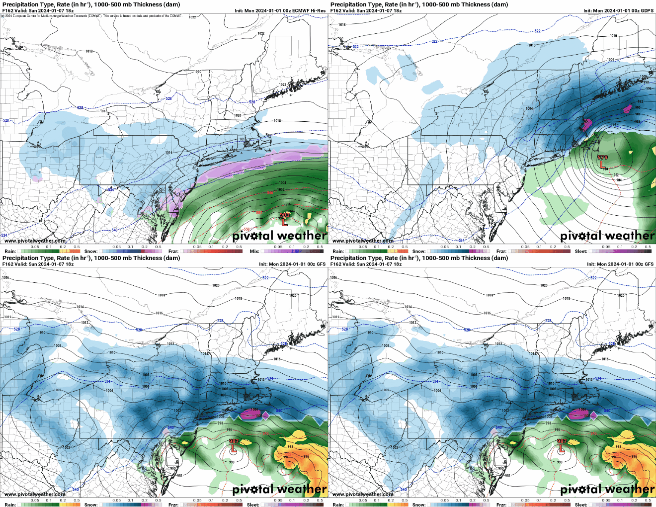
Low pressure moving out of the Tennessee Valley will redevelop near the Mid-Atlantic coastline, while high pressure builds into southeastern Canada. The developing low pressure system should pass south of New England while strengthening. Obviously, this is a week away, and we don’t want to get too detailed at this point, but things can and likely will change between now and then. but the potential exists for our first significant snowstorm of the winter on Sunday. There’s lots to iron out, such as where (if?) the rain/snow line will be? Will there be strong winds? How much of an impact will this storm have along the coast? Where will the heaviest snow fall (Or will there be any heavy snow?) There are too many questions, right now, and it’s just too early to answer them. However, consider this an early warning that there could be an impactful storm next Sunday. We’ll obviously have a much more detailed look at this potential storm in our Weekend Outlook on Thursday.

The models all show the potential for a storm on Sunday, but the details are still very much in question. Images provided by Pivotal Weather.

Monday: Morning clouds, then becoming partly to mostly sunny in the afternoon. High 33-40.

Monday night: Clear skies. Low 20-27.

Tuesday: Plenty of sunshine. High 33-40.

Tuesday night: Clear skies, some clouds start to move in late at night. Low 24-31.

Wednesday: Sunshine and a few clouds. High 37-44.

Thursday: Mostly cloudy, breezy, chance for a few rain or snow showers. High 36-43.

Friday: Mostly sunny, breezy, cooler. High 32-39.

Saturday: Morning sun, then increasing afternoon clouds. High 34-41.

Sunday: Cloudy and becoming windy with snow or rain possible. High 31-38.

Weekend Outlook: December 29, 2023 – January 1, 2024

It seems only fitting that 2023 ends on a wet note since it’s been an extraordinarily wet year across the region.

2023 will go down as one of the Top 10 wettest years on record across most of the region. Image provided by the Southeast Regional Climate Center.

Low pressure pulls away from the region this evening, with rain tapering off to showers. However, with an upper-level low slowly moving in, we’ll have plenty of clouds with occasional showers for much of Friday and at least the first half of Saturday. Neither day will be a washout, but they won’t exactly be nice days either. Temperatures will remain above normal for these days. By late Saturday, we’ll start to clear out as high pressure builds in, with drier but also cooler weather returning. For First Night celebrations, it should be dry with temperatures near or a little above normal, unlike some of the rather chilly New Year’s Eves we’ve had in the past. A weak disturbance will move through on New Year’s Day with some clouds and possibly a stray rain or snow shower, but for the most part, it will remain dry.

Wet weather hangs around across the Northeast for the next couple of days. Loop provided by Tropical Tidbits.

Thursday night: Cloudy with rain tapering off to showers. Low 37-44.

Friday: Plenty of clouds with occasional showers. High 41-48.

Friday night: Cloudy with a few showers. Low 35-42.

Saturday: Showers around during the morning, some clearing late in the day. High 42-49.

Saturday night: Gradual clearing. Low 26-33.

Near Year’s Eve: Sunshine and some late-day clouds, cooler. High 35-42.

Sunday night: Partly cloudy. Low 25-32.

New Year’s Day: Partly sunny, slight chance for a rain or snow shower. High 36-43.

Weekly Outlook: December 25, 2023 – January 1, 2024

Did you get a new knit hat and mittens for Christmas or Hanukkah? Perhaps a new winter coat? Well, you won’t need them much, if at all, during most of the final week of 2023.

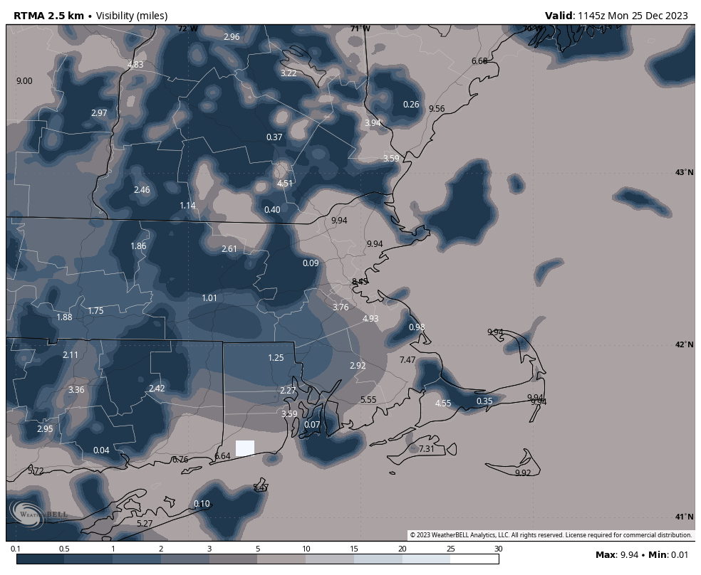
Areas of dense fog reduced visibility to under half a mile in spots to start Christmas Day. Image provided by WeatherBell.

We’ve got some dense fog to start Christmas Day, but once it burns off this morning, skies will remain mostly cloudy for the balance of the day, but it will be on the mild side. The fog returns tonight, but Tuesday may see some sunny breaks develop once the fog burns off. Wednesday is where things start to get interesting. The low pressure system producing all sorts of nasty weather in the Plains and Upper Midwest will head into the Great Lakes, sending some showers in on Wednesday. At the same time, a second low pressure system will develop near the Carolina coast and head north-northeastward. This will bring some steadier rain in by late Wednesday, more likely Wednesday night into Thursday morning, before the system pulls away. An upper-level low pressure will then move into the East Coast, and it may spawn a weak low at the surface on Friday, which could triggering a few rain or snow showers across the region. The upper-level low moves directly overhead on Saturday, resulting in some cooler conditions, plenty of clouds, and possible another snow shower or two. High pressure builds in with dry and cool conditions for New Year’s Eve. Another weak system may move in on New Year’s Day with some snow showers possible.

Some models show the potential for some heavy rainfall with the storm later Wednesday into Thursday. Images provided by Pivotal Weather.

Christmas Day: Dense fog early, then becoming partly to mostly sunny. High 46-53.

Monday night: Mostly cloudy, fog redevelops. Low 33-40.

Tuesday: More clouds than sunshine. High 46-53.

Tuesday night: Cloudy, chance for a shower or two late at night. Low 36-43.

Wednesday: Cloudy with a few showers, becoming a steady rain at night. High 47-54.

Thursday: Mostly cloudy and breezy, rain ending in the morning. High 47-54.

Friday: Mostly cloudy, breezy, chance for a few rain or snow showers. High 41-48.

Saturday: Partly sunny, breezy, chance for a few flurries. High 35-42.

New Year’s Eve: A mix of sun and clouds. High 34-41.

New Year’s Day: Partly sunny, breezy, chance for a snow shower. High 36-43.

Weekend Outlook: December 22-25, 2023

Quiet weather is expected for the vast majority of Christmas weekend.

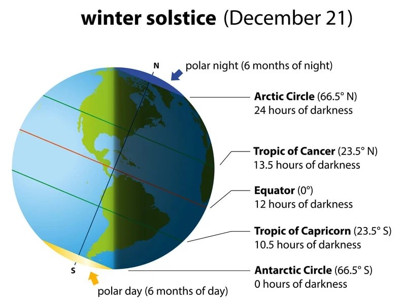
The winter solstice occurs at 10:27pm tonight. Days start getting longer tomorrow until June. Images provided by the Farmer’s Almanac.

Summer officially begins at 10:27pm this evening in the southern hemisphere, which means that is when winter begins here. While it’ll be seasonably chilly to start, much of the holiday weekend won’t feel a lot like winter. We’ll have high pressure in control to start, a chilly night tonight, and a cool by sunny day on Friday. Clouds start to move in Friday night and Saturday ahead of a weak disturbance heading this way from the Midwest. It may produce a few rain or snow showers late Saturday night or early Sunday morning as it moves through, but most of us will remain dry. After that, high pressure builds back in for Christmas Eve and Christmas Day with dry and mild conditions.

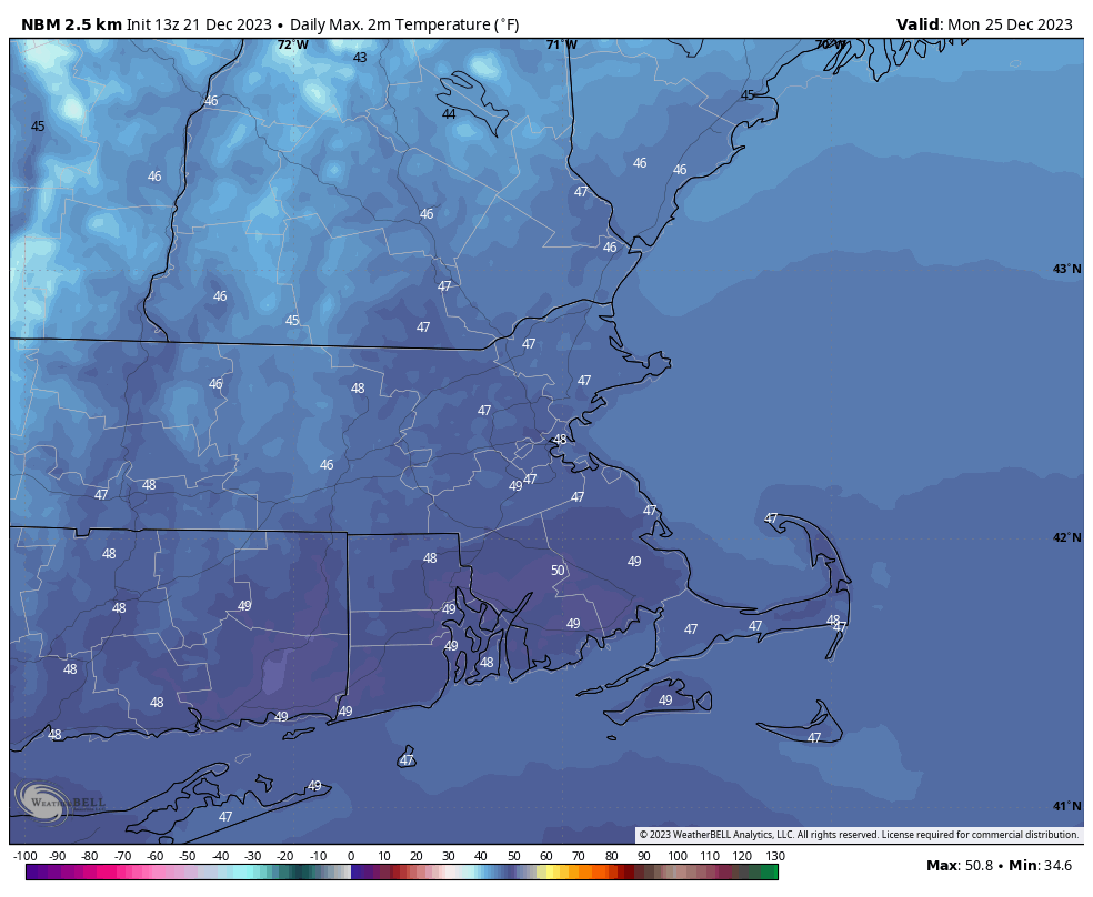
Temperatures could approach 50 Christmas afternoon. Image provided by WeatherBell.

Thursday night: Clear and chilly. Low 16-23.

Friday: Plenty of sunshine. High 31-38.

Friday night: Clear to partly cloudy. Low 18-25.

Saturday: Increasing clouds. High 37-44.

Saturday night: Mostly cloudy, a rain or snow shower possible after midnight. Low 28-35.

Christmas Eve: More clouds than sunshine, milder. High 42-49.

Sunday night: Partly to mostly cloudy. Low 31-38.

Christmas Day: Partly sunny. High 45-52.

Weekly Outlook: December 18-25, 2023

Wet n Wild was the name of a water park in Orlando that closed many years ago, but it also could describe our weather today.

Wet n Wild may be gone from Orlando, but it’ll be an apt description of our weather today. Image provided by Tripadvisor.

Low pressure will move up the Hudson Valley today, producing rain, some of it heavy during the morning, but it will taper off during the afternoon, ending during the evening. Many places could see 1-3 inches of rain, resulting in flooding in some areas. Luckily, it’s been dry for the past couple of months after a very wet summer, so river levels have dropped quite a bit, and many of them can handle this amount of rain. Rain isn’t the only threat with this storm though. Strong southeast to south winds are likely today, which could result in tree and power line damage. The strong winds may also result in some coastal flooding along south-facing coastlines. The gusty south winds will also bring unseasonably mild air in, with temperatures approaching or topping 60 by midday. Once the system passes our latitude, winds will shift into the west and southwest this afternoon. They won’t be as strong as in the morning, but will be quite gusty, and will bring a quick end to the mild air.

Wind gusts in excess of 50 mph are possible across much of the region today. Image provided by WeatherBell.

The system pulls away Monday night with the rain ending and winds rapidly diminishing, but an upper-level low moves into the Northeast on Tuesday. This will bring in more clouds, with a few showers popping up, possibly mixed with a little wet snow. High pressure then builds in for Wednesday through Friday with sunshine and seasonably cool temperatures. We do have to keep an eye on an ocean storm well to our east. Some of the models try to drift it close enough to bring in some clouds towards Thursday or Friday, or possibly even some showers, but right now, we’re thinking that we’ll stay dry. A weak system may bring in some clouds and possibly some rain or snow showers on Saturday, then we should be dry and a little milder for Christmas Eve and Christmas Day.

Looking like a Green Christmas with temperatures 5-10 degrees above normal. Image provided by weathermodels.com

Monday: Rain, heavy at times during the morning, tapering off to showers in the afternoon, very windy, with gusts to 50 mph or higher, especially along the coast. High 56-63.

Monday night: Showers end in the evening, some clearing overnight, winds rapidly diminishing. Low 33-40.

Tuesday: Intervals of clouds and sun, chance for a few rain or snow showers, much cooler. High 41-48.

Tuesday night: Clearing. Low 24-31.

Wednesday: Mostly sunny, breezy at times. High 37-44.

Thursday: Sunshine and a few clouds, breezy again. High 36-43.

Friday: Partly sunny, a bit breezy, especially early. High 33-40.

Saturday: A mix of sun and clouds, slight chance for a few rain or snow showers. High 35-42.

Christmas Eve: Partly to mostly sunny. High 39-46.

Christmas Day: Partly sunny. High 42-49.

Weekend Outlook: December 15-18, 2023

This weekend is going to end up very similar to last weekend, dry to start, then very wet to end.

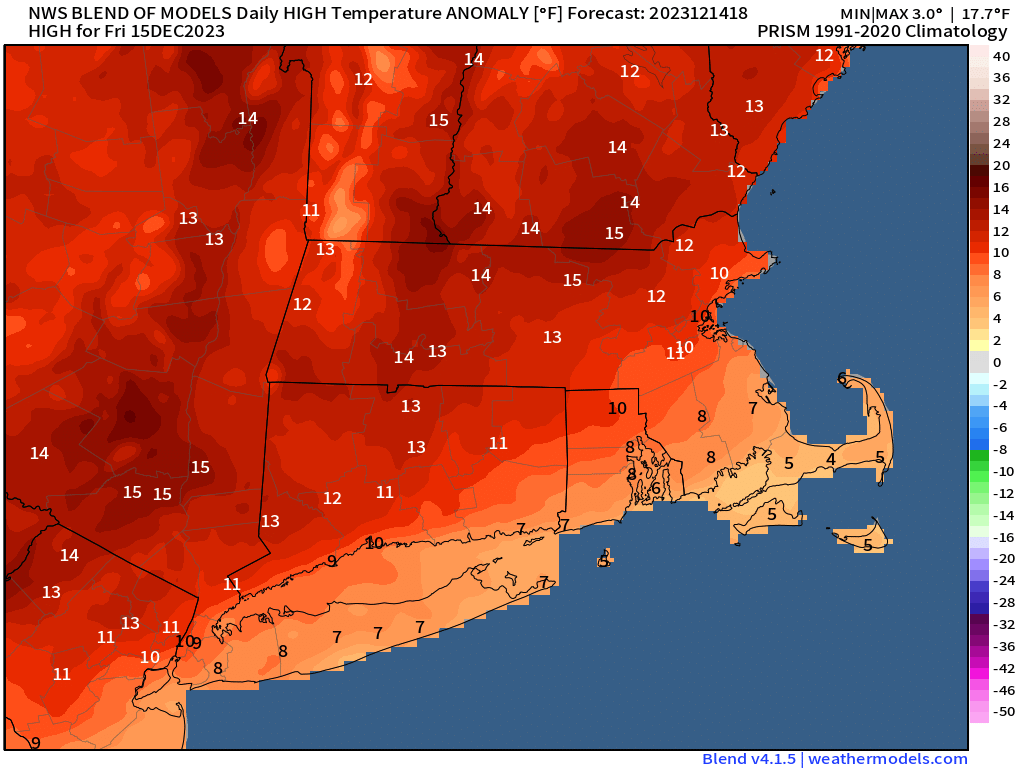
Temperatures will be as much as 10-15 degrees above normal across much of the region on Friday. Image provided by weathermodels.com.

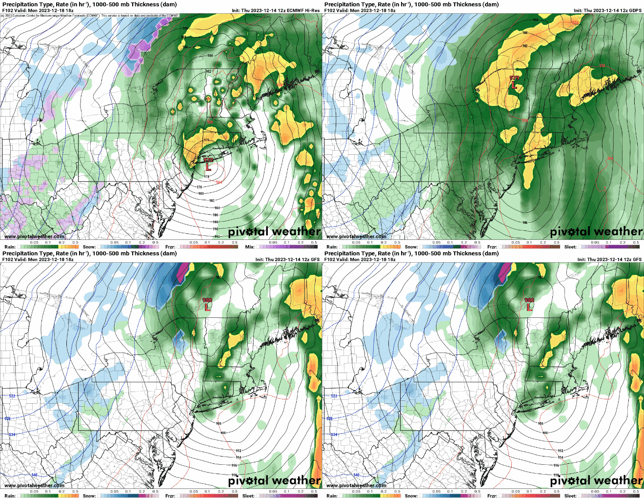
High pressure keeps us dry into Saturday. We’ll start off chilly this evening under clear skies, but as winds shift into the southwest, temperatures will level off toward midnight, and could rise a bit overnight. Friday is about as good a day as we can expect for mid-December with sunshine and above normal temperatures. Clouds start to filter in Friday night and during the day on Saturday as low pressure begins to develop across the Southeast. As that low moves northward, we’ll have plenty of clouds on Sunday, with rain moving in by late afternoon or evening. The rain will likely be heavy Sunday night into Monday morning, with some gusty south winds bringing unseasonably mild air back in, with temperatures making a run at 60 in some spots. Monday is where the models start to diverge. Some of them bring the storm well to our west (central or western NY), some a little closer (western MA). Overall, this doesn’t make too much of a difference at this point, but the eastern track would likely mean the rain ends earlier, and the cold front swings through earlier, bringing an end to the mild air. Beyond that, the models rapidly diverge, which has significant impacts on the forecast around here for Tuesday and into midweek, but this forecast only goes through Monday, so we’ll worry about next week in our Weekly Outlook Sunday night.

Where will the storm be centered Monday afternoon? It makes a difference for the forecast. Images provided by Pivotal Weather.

Thursday night: Clear skies. Low 26-33 during the evening, temperatures may rise a little after midnight.

Friday: Plenty of sunshine, breezy at times, especially through early afternoon. High 45-52.

Friday night: Clear skies during the evening, some clouds start to move in overnight. Low 32-39.

Saturday: Intervals of sunshine and clouds. High 43-50.

Saturday night: Becoming mostly cloudy. Low 29-36.

Sunday: Cloudy and becoming breezy with rain developing late in the day. High 47-54.

Sunday night: Periods of rain, possibly heavy at times, becoming windy. Low 44-51 during the evening, temperatures rise overnight.

Monday: Windy and mild with more rain, tapering off during the afternoon. High 54-61.

Weekly Outlook: December 11-17, 2023

Once we get past today, much of the week will be fairly quiet weatherwise. Today will not be quiet at all though.

Wind gusts of 40-50 mph will be common this morning and early afternoon, with some stronger gusts across southeastern Massachusetts. Image provided by WeatherBell.

A strong cold front moves through early this morning, with rain ending by midday as the front pushes offshore. Gusty winds west behind the front usher much cooler air into the region. After a mild start, temperatures will drop through the morning. They may level off a little towards midday, especially as the rain ends, then we’ll drop again by late afternoon and evening as skies clear out. High pressure builds in for Tuesday with plenty of sunshine and seasonably cool temperatures. Another cold front moves through on Wednesday, but it will be starved for moisture, so it will only generate a few clouds, and possibly a stray snowflake or two. High pressure returns for Thursday through the weekend. We’ll be rather chilly on Thursday as the high builds in, then temperatures slowly moderate. There is one potential fly in the ointment. Many of the models generate a pretty potent storm in the Gulf of Mexico toward the end of the week or the weekend, and try to have it start moving up the coast. However, the big high sitting in place will slow down that storm’s progress by acting as a roadblock. Some models don’t have the rain with the system ever get up here, so wait until Monday or Tuesday, and some have it move in as early as late Sunday. We’re leaning toward the drier scenario for now, but obviously should have a better idea when we publish our Weekend Outlook on Thursday.

The next storm likely doesn’t impact us through at least the end of the weekend, if at all, but that’s not set in stone just yet. Images provided by Pivotal Weather.

Monday: Rain ending by midday, some late-day clearing is possible, windy. High 40-47 early, except warmer across southeastern Massachusetts and Cape Cod, where temperatures drop during the morning, then hold steady in the lower to middle 40s for early afternoon.

Monday night: Becoming mostly clear with diminishing winds. Low 25-32.

Tuesday: Plenty of sunshine. High 37-44.

Tuesday night: Clear skies. Low 28-35.

Wednesday: Sunshine and a few clouds, breezy. High 37-44.

Thursday: Sunny, breezy, and chilly. High 31-38.

Friday: Mostly sunny, breezy again, milder. High 43-50.

Saturday: Partly sunny. High 41-48.

Sunday: Intervals of clouds and sun. High 43-50.