Some rain is on the way along with milder temperatures as we head towards the weekend.
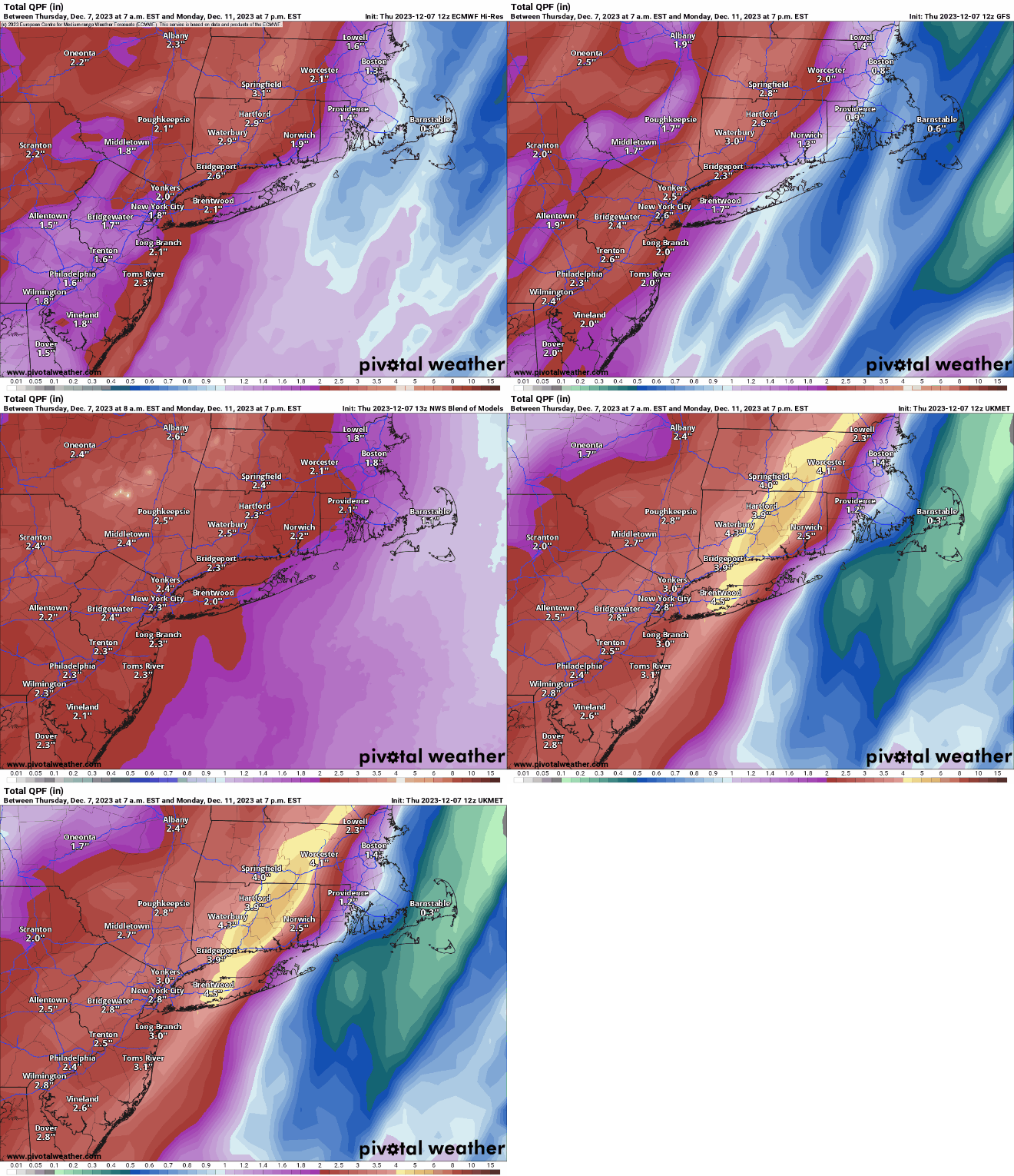
Some very heavy rain is possible Sunday night, especially well inland. Images provided by Pivotal Weather.
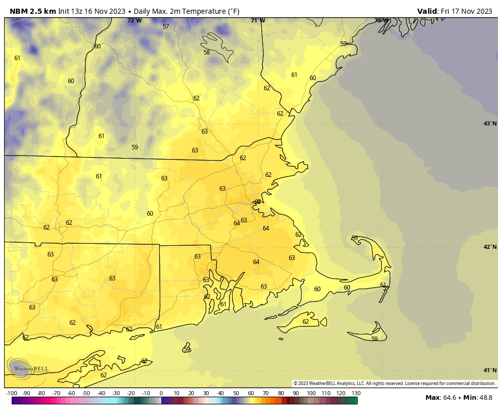
We start off with high pressure in control, keeping us dry through Saturday. Temperatures will be chilly tonight, but as the high moves off to the east, we’ll start to moderate for Friday and Saturday. Friday should feature a decent amount of sunshine, but clouds will increase and thicken up during the day on Saturday as low pressure heads toward the Great Lakes. As that low heads into southeastern Canada, southerly winds will start to pick up on Sunday, resulting in quite a mild day, with temperatures likely getting close to 60 degrees in many locations. It looks like most of the rain should hold off until late in the day, but once it moves in, some heavy rain is possible Sunday night into Monday morning. South to southwest winds will be quite gusty at night as well. The low will drag a cold front across the region Monday morning, with the rain ending by early afternoon. Once the front moves through, west to northwest winds will usher much cooler air in. So, even though we’ll likely start the day well into the 50s, we’ll drop in the 40s by afternoon. Skies should start to clear out by late in the day.
Temperatures could still be in the 60s Monday morning ahead of a strong cold front. Image provided by WeatherBell.
Thursday night: Becoming mostly clear. Low 17-24.
Friday: Sunshine and some afternoon clouds. High 38-45.
Friday night: Clear during the evening, some clouds move in overnight. Low 26-33.
Saturday: Increasing and thickening clouds, milder. High 46-53.
Saturday night: Partly to mostly cloudy. Low 35-42.
Sunday: Mostly cloudy, becoming breezy and mild, rain developing late in the day. High 55-62.
Sunday night: Windy with periods of rain, possibly heavy at times. Low 52-59.
Monday: Rain ending around midday, some late-day clearing, still breezy. High 52-59 in the morning, temperatures drop through the afternoon.
Some cooler weather is on the way over the next few days.
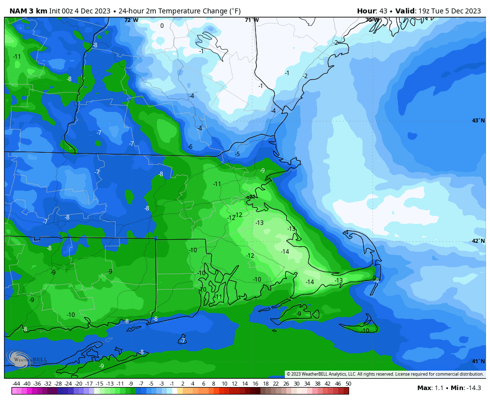
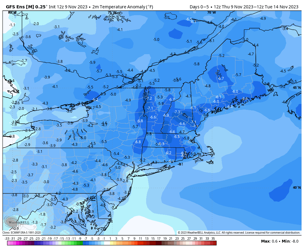
Tuesday will be 10-15 degrees cooler than today across the region. Image provided by WeatherBell.
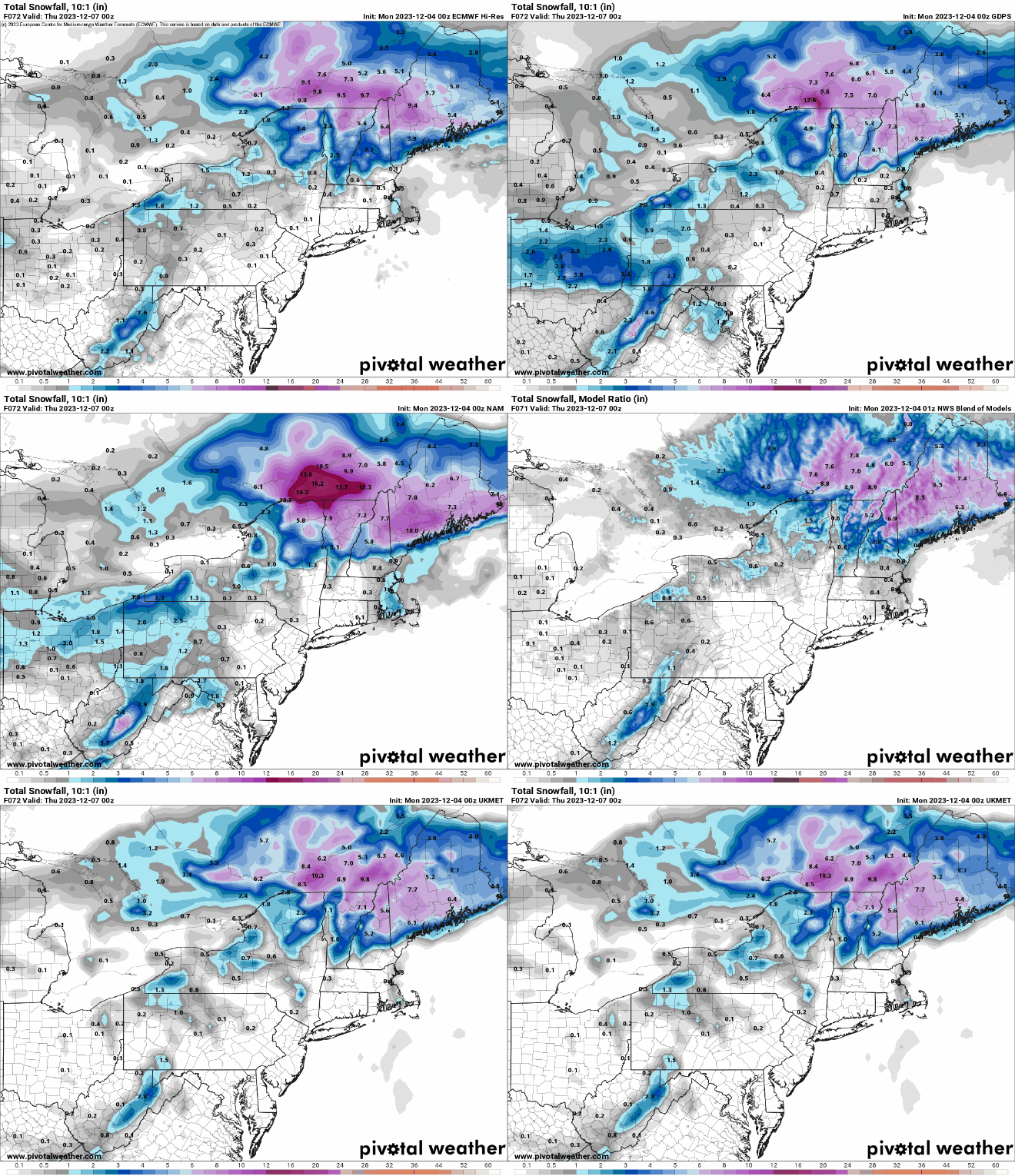
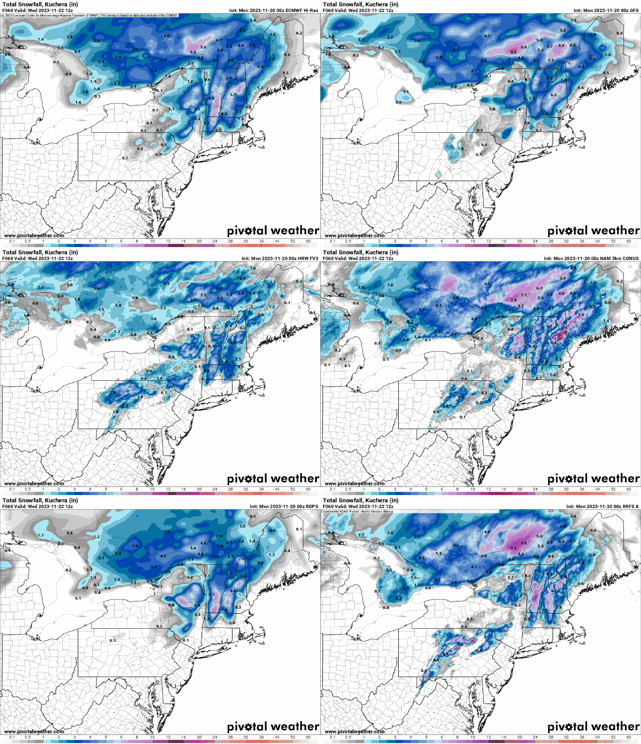
We’ll start to dry out today, but plenty of clouds will remain in place, and there could be a stray shower as an upper-level disturbance crosses the Northeast. Tuesday will be a dry day but a little cooler as high pressure tries to build in. Things could get a little interesting Tuesday night and Wednesday. Low pressure will pass well offshore, but an extension of it, called an inverted trough, may set up. Normally, trough of low pressure are oriented in a general north-south direction from low pressure to the north. In this case, it’ll be the opposite, south-north from low pressure well to the south, hence the “inverted” part. What this will serve to do is enhance some onshore winds, which will in turn generate some precipitation. With colder air settling in, that precipitation will likely fall as snow. Now, this isn’t a big snowstorm we’re talking about, but across eastern Massachusetts, Rhode Island, and southern New Hampshire, we could see an inch or two in spots, especially across southeastern Massachusetts.
A little bit of snow seems likely for Tuesday night and Wednesday for parts of the region. Images provided by Pivotal Weather.
High pressure builds back in for Thursday, which will likely be a rather chilly day. High pressure slides off to the east, allowing temperatures to moderate for Friday and Saturday. The next system approaches on Sunday, but there are timing issues to be worked out with this storm. Some rain is possible during the day, but for now, it looks like most of the rain will hold off until Sunday night and Monday. This is subject to change however as the models start to hone in on the eventual solution. It does look like Sunday could be quite a mild day ahead of the storm, but again, let’s not etch that in stone just yet, since it is 6 days away.
Temperatures could get well into the 50s on Sunday. Image provided by Weathermodels.com
Monday: Intervals of clouds and sun, slight chance for a shower. High 45-52.
Monday night: Partly to mostly cloudy. Low 29-36.
Tuesday: More clouds than sun, cooler. High 36-43.
Tuesday night: Mostly cloudy with some light snow or snow showers around. Low 24-31.
Wednesday: Mostly cloudy, light snow or snow showers ending. High 32-39.
Thursday: A mix of sun and clouds. High 31-38.
Friday: Partly sunny. High 39-46.
Saturday: Intervals of clouds and sun. High 47-54.
Sunday: Mostly cloudy, breezy, and mild with scattered showers. High 51-58.
Some unsettled weather is on the way for the weekend, so get those umbrellas out.
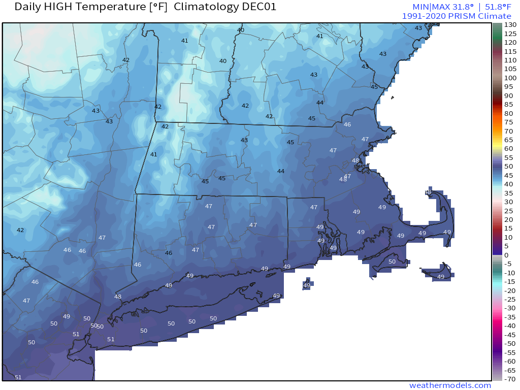
Temperatures will be close to the normal highs in the middle to upper 40s over the next few days. Image provided by Weathermodels.com
High pressure remains in control into Friday morning with dry and seasonably cool conditions. Clouds will thicken up on Friday as a weak storm system moves toward the region. A period of showers is likely late Friday afternoon and evening, but we’re not expecting any heavy rain at this point. After that, a series of weak systems will move through over the weekend, keeping the clouds in place with slightly cooler temperatures, and some episodes of rain showers. We’re not expecting them to be widespread or heavy, but they’ll be enough of a nuisance that you’ll notice them. A more potent system looks to move in for late Sunday into Monday. There is still quite a bit of uncertainty among the models as the how this storm will evolve and track, but right now, it looks like it will move across southeastern New England early Monday. This will likely result in rain, possibly heavy, for much of the region, with some gusty winds near the coast. Temperatures will be on the cool side, except near the South Coast and Cape Cod, which could be on the warm side of the storm. The area with the most uncertainty is across southern New Hampshire and the hills of central Massachusetts. At least one model is showing the potential for enough cold air for some snow or a wintry mix both at the start and at the end of the storm, but this is far from a certainty. In fact, the majority of the models do not show this scenario, but that doesn’t mean we should just discount it.
The models all have different ideas for what will happen on Sunday. Images provided by Pivotal Weather.
Thursday night: Partly cloudy. Low 33-40.
Friday: Some morning sun, then clouds return, showers develop by late afternoon. High 48-55.
Saturday: Plenty of clouds with a few showers possible. High 48-55.
Saturday night: Mostly cloudy, chance for a shower or two. Low 37-44.
Sunday: Cloudy with light rain and showers redeveloping, possibly some wintry mix from the hills of central Massachusetts into southwestern New Hampshire. High 44-51.
Sunday night: Periods of rain and showers. Low 34-41.
Monday: Cloudy with occasional showers, possibly mixed with some snow from central Massachusetts into southern New Hampshire. High 43-50.
The week starts off rather mild, but cooler and drier weather is on the way.
Wind chills will be in the teens Wednesday morning when you head out the door Image provided by WeatherBell.
Low pressure heads into the Gulf of Maine this morning, allowing skies to quickly clear out, but winds will become gusty out of the northwest, ushering some cooler air into the region. High pressure builds in for the next several days, with Tuesday and Wednesday featuring cool and breezy conditions. With an upper-level trough of low pressure overhead, we’ll start these days with sunshine, but clouds will develop by midday, with a few pop-up snow or rain showers possible, but they’ll be few and far between. There could be some ocean-effect rain or snow showers across Cape Cod on Tuesday as well. By Thursday, temperatures will start to moderate as high pressure slides off to the east. Another weak storm system will move out of the Great Lakes on Friday, likely spreading some rain showers in late Friday into early Saturday. High pressure then builds in with cooler and drier conditions for the weekend. Clouds start to move back in late Sunday ahead of yet another storm system, but we’ll get into more detail on that one in our Weekend Outlook on Thursday.
The models all show some rain Friday night, but disagree on the track of the storm, which will impact temperatures. Images provided by Pivotal Weather.
Monday: Becoming partly to mostly sunny, breezy. High 48-55 this morning, temperatures may start to drop in the afternoon.
Monday night: Clear through the evening, a few clouds overnight. Low 25-32.
Tuesday: A mix of sun and clouds, chance for a few widely scattered sprinkles or flurries, breezy. High 34-41.
Tuesday night: Clear skies. Low 21-28.
Wednesday: Partly sunny. High 32-39.
Thursday: Sunshine and some afternoon clouds, breezy, not as cool. High 41-48.
Friday: Partly to mostly cloudy, showers likely late in the day and at night, breezy. High 48-55.
Saturday: Early showers, then becoming partly sunny, breezy. High 43-50.
The weather will be more tranquil but also cooler for a good chunk of the extended holiday weekend.
Wind chills will be in the teens Saturday morning, so bundle up if you’ll be ehading out. Image provided by WeatherBell.
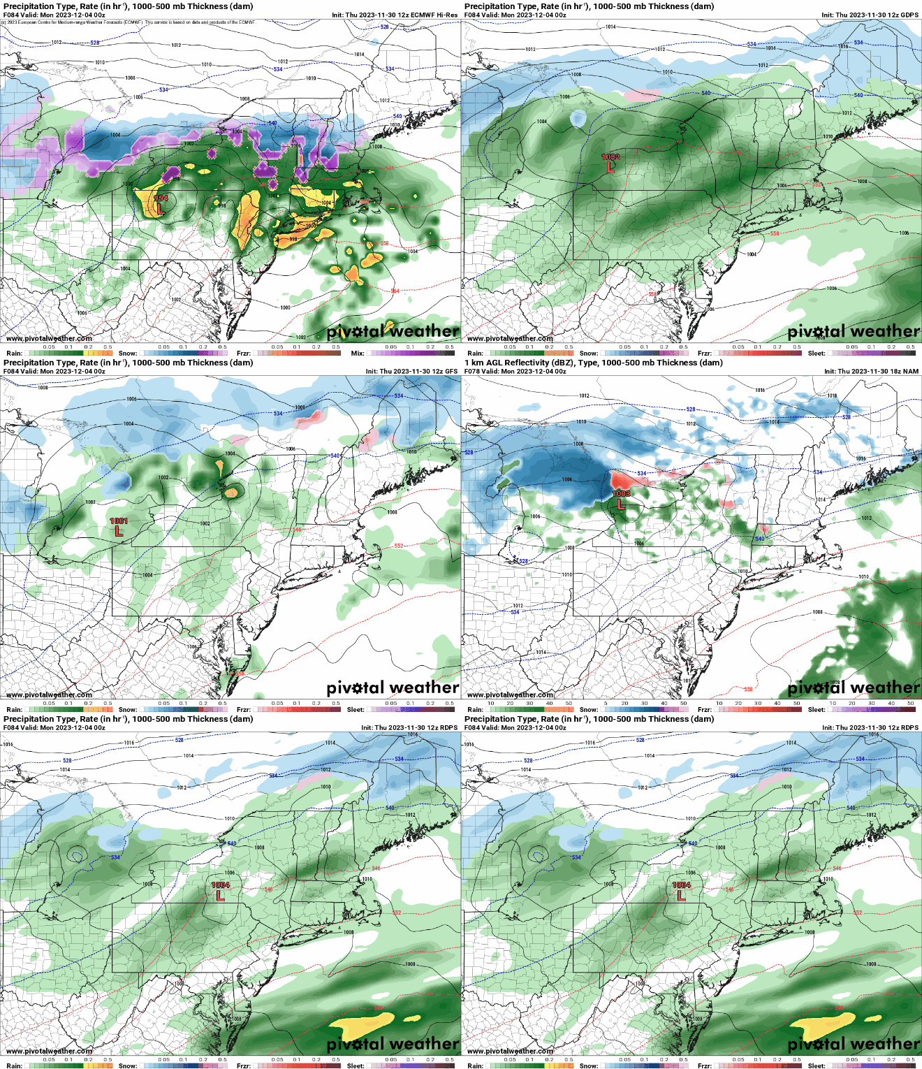
Low pressure pulls away this evening with rain ending, and skies slowly clearing out overnight. High pressure builds in for Thanksgiving with sunshine and seasonably cool temperatures, but it will remain breezy as our low pressure system continues to intensify in Atlantic Canada. Another cold front moves through on Friday, but with only a few clouds accompanying it. Behind it, even colder air will settle in for Friday night and Saturday on gusty northwest winds. Temperatures on Saturday likely stay in the 30s for highs, with lows Saturday night dropping into the 20s, with some teens in the normally colder locations. Keep this in mind if you’ll be out during the day Saturday or at night. Temperatures will start to moderate on Sunday, but clouds will also stream in ahead of both a low pressure system moving off the Mid-Atlantic coast and another cold front moving in from the west. A period of rain showers seems likely Sunday night into Monday morning as the low passes by offshore and the cold front moves in. Temperatures may be marginally cold enough for some snow to mix in at the start well north and west of Boston. We’ll start to clear out behind both systems Monday afternoon.
There are still some differences to be worked out among the models for our Sunday night storm system. Images provided by Pivotal Weather.
Wednesday night: Any lingering showers end this evening, skies start to clear out after midnight, breezy. Low 34-41.
Thanksgiving: Plenty of sunshine, breezy. High 44-51.
Thursday night: Clear skies. Low 30-37.
Friday: A mix of sun and clouds, breezy. High 42-49.
Friday night: Clear skies. Low 17-24.
Saturday: Sunshine and some afternoon clouds. High 31-38.
Saturday night: Partly cloudy. Low 22-29.
Sunday: Becoming partly to mostly cloudy. High 41-48.
Sunday night: Cloudy with showers likely, possibly starting as a little wet snow well north and west of Boston. Low 31-38.
Monday: Morning showers, some afternoon clearing, breezy. High 44-51.
Thanksgiving week has arrived, but before we get to the holiday we’ve got a complicated forecast.
Better find the winter gear, temperatures will drop into the teens in some places Tuesday morning. Image provided by WeatherBell.
The week starts off simple enough with high pressure bringing us sunshine and cool conditions. It’ll be breezy at times, making it feel even cooler, with wind chills in the 20s and lower 30s. Tuesday starts off chilly, but we’ll see clouds start to move in as low pressure heads towards the Great Lakes. A secondary area of low pressure will develop off of the Mid-Atlantic coast Tuesday evening, passing near or just south of the South Coast on Wednesday while the main low passes by to the north. They’ll combine to bring us a windy and wet day on Wednesday, also known as the busiest travel day of the year. However, the rain and wind isn’t the entire story. We’ve left out a big detail, one that many of you probably won’t like. The precipitation will move in towards midnight Tuesday night, and temperatures at that time will probably be close to freezing. That means that it will likely start as snow (or sleet), especially north and west of Boston. Once you get outside of I-495, there could even be some accumulation before the change to rain washes everything away. Once you get into the hills of Worcester County and the Monadnocks of southwestern New Hampshire, there could be a few inches before the changeover. Yes folks, it’s that time of year, whether you like it or not, to use an overused phrase – “Winter is Coming.”
Most of the accumulating snow will be well north and west of Boston Tuesday night. Images provided by Pivotal Weather.
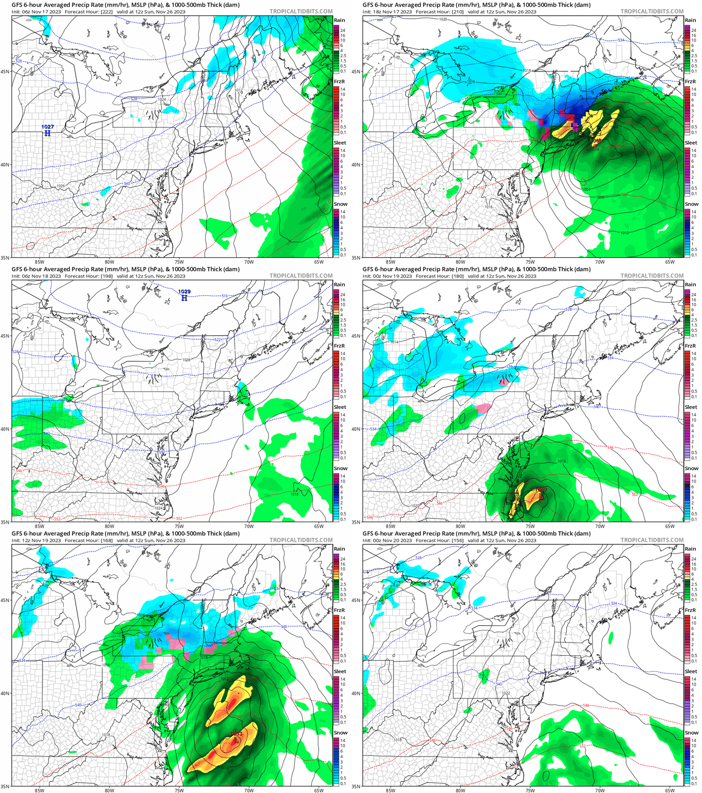
The rain tapers off Wednesday afternoon, but likely doesn’t completely end until evening, but then high pressure builds in with sunshine and cool temperatures again for Thanksgiving. So, if you’re traveling locally, you shouldn’t have any issues, but if you’re heading out to one of the high school football games make sure you dress appropriately, because it will be on the chilly side. Friday looks similar to Thanksgiving with dry and cool conditions once again, but the weekend isn’t looking as nice. Another system will likely move up the coast, and this one *should* be mostly rain, but the various forecast models don’t agree on much with this storm, including how strong it will be, the track it will take, or even whether it will impact us on Saturday or Sunday or not at all. We’ll take a deeper dive on that system when we publish our Weekend Outlook, which will be out on Wednesday this week instead of the usual Thursday.
The last 3 days worth of GFS forecast runs show how inconsistent the model has been with the forecast for next weekend. Images provided by Tropical Tidbits.
Monday: Plenty of sunshine, a little breezy at times. High 34-41.
Monday night: Clear skies through the evening, some clouds start to move in after midnight. Low 18-25.
Tuesday: Becoming mostly cloudy. High 36-43.
Tuesday night: Cloudy and becoming windy snow developing around midnight north and west of Boston, changing to sleet and rain before daybreak, rain developing elsewhere. Low 30-37 during the evening, temperatures rise after midnight.
Wednesday: Cloudy and windy with rain likely, possibly heavy at times in the morning, tapering off to showers by early afternoon, ending in the evening. High 46-53, possibly a little warmer across southeastern Massachusetts and Cape Cod.
Thanksgiving: Mostly sunny, breezy. High 43-50.
Friday: Partly sunny. High 42-49.
Saturday: Mostly cloudy, breezy, chance of rain. High 39-46.
Sunday: Partly to mostly cloudy, breezy, chance of rain. High 39-46.
Lots of change is in the air for the weekend, from warm to cool, from wet to dry, from windy to calm.
Temperatures should get well into the 60s for most of us on Friday. Image provided by WeatherBell.
High pressure is in control to start the weekend with dry weather for tonight and Friday. Temperatures will turn milder as winds shift into the southwest with the high pressure area moving off to our east. However, clouds will be streaming in ahead of both an approaching cold front and a low pressure area moving up the East Coast. The low pressure area is the one that has been drenching Florida for the past couple of days, but right now, it looks like it will stay far enough offshore to only bring in some rain to parts of Cape Cod and the Islands and possibly southeastern Massachusetts. However, the cold front will also bring in some showers for Friday night into Saturday morning. Saturday will start off quite mild, likely in the 50s for most spots, but with the front moving through, not only will it bring an end to the rain, it will usher much cooler weather in on gusty northwest winds. Temperatures will likely drop trough the afternoon, with skies clearing out late in the day. High pressure builds in for Sunday and Monday with sunshine and cool conditions, but it will likely remain breezy, especially on Sunday, as low pressure strengthens in Atlantic Canada.
This system shouldn’t be a big rain-maker for most of the region. Images provided by Pivotal Weather.
Thursday night: Clear skies through the evening, clouds start to move in after midnight. Low 34-41.
Friday: Increasing and thickening clouds, breezy, and mild. High 58-65.
Friday night: Cloudy with showers developing, mainly after midnight. Low 47-54.
Saturday: Rain and showers end by early afternoon, skies start to clear out late in the day, becoming breezy and turning cooler in the afternoon. High 52-59 in the morning, temperatures drop in the afternoon.
Saturday night: Clear skies, breezy during the evening. Low 28-35.
Sunday: Plenty of sunshine, breezy. High 44-51.
Sunday night: Clear skies, breezy. Low 25-32.
Monday: Sunshine and a few clouds, still a bit breezy. High 38-45.
We’ve got an extended stretch of dry weather coming up and as a bonus, it’s going to turn milder too.
A few rain or snow showers are possible later today. Loop provided by Weathermodels.com
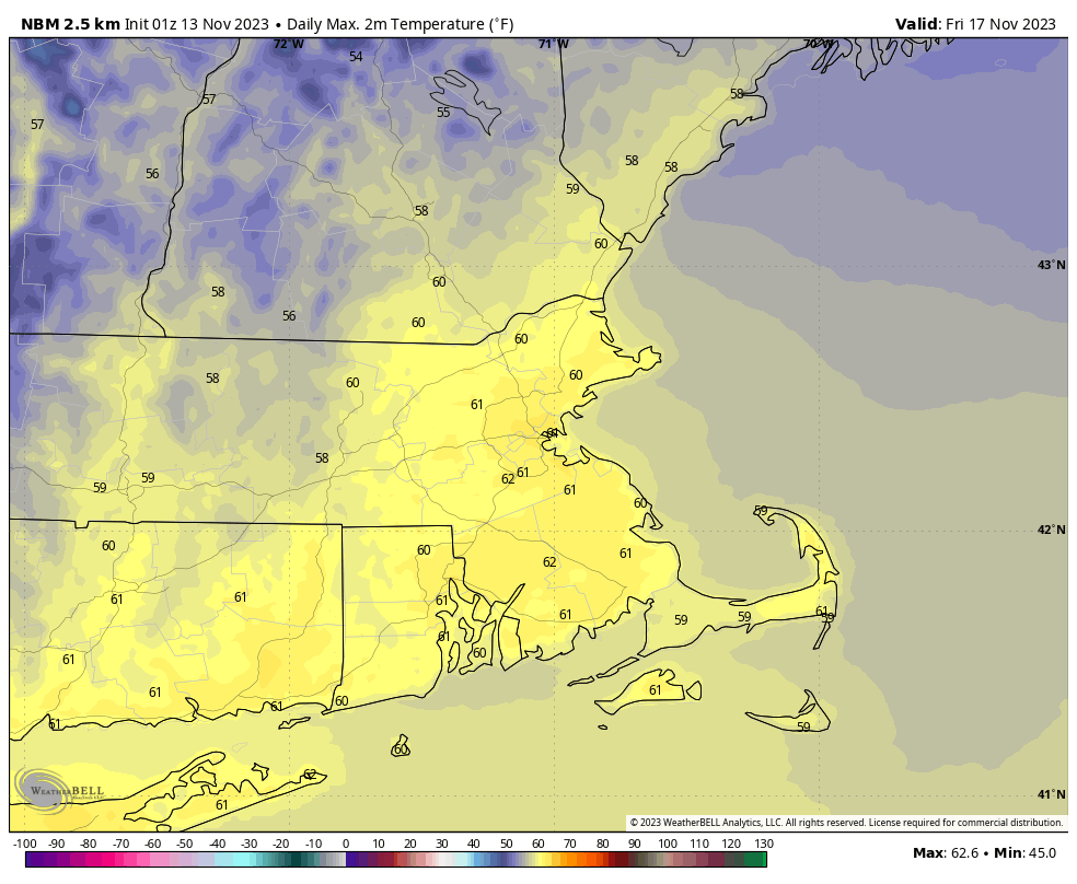
We’ll start the week with some sunshine, but clouds move in this afternoon ahead of a weak disturbance. That system may produce a few rain or snow showers late this afternoon and evening, but they’ll be widely scattered and very light. Skies clear out behind that system as high pressure builds in, setting up a sunny but chilly day on Tuesday. There may be a few ocean-effect rain or snow showers across the Outer Cape, but the rest of us will stay dry. Wednesday and Thursday look dry as well with high pressure in control, but temperatures should start to moderate by Thursday as the high slides off to the east. Clouds return on Friday ahead of the next storm system. We’ll be fairly mild ahead of that storm, with some rain likely late Friday into early Saturday. Once that system moves offshore, high pressure returns with drier and cooler conditions again on Sunday.
Temperatures could top 60 in many areas on Friday. Image provided by WeatherBell.
Monday: Morning sunshine gives way to increasing afternoon clouds, a late-day rain or snow shower is possible. High 39-46.
Monday night: A rain or snow shower during the evening, some clearing after midnight. Low 26-33.
Tuesday: Becoming partly to mostly sunny, a rain or snow shower is possible across the Outer Cape. High 43-50.
Tuesday night: Clear skies. Low 27-34.
Wednesday: Sunshine and some afternoon clouds. High 44-51.
Thursday: Mostly sunny. High 53-60.
Friday: Becoming mostly cloudy, rain possible late in the day, more likely at night, windy. High 56-63.
Saturday: Rain ending early, some clearing in the afternoon, breezy. High 52-59.
Sunday: Partly to mostly sunny and breezy. High 44-51.
Another dry weekend coming up? Where were these during the summer?
If you were up early enough this morning, some parts of the region had some sleet or even a few wet snowflakes for the first time this season. Don’t worry, they won’t be back for a while. Any lingering rain showers will end this evening, and while we may see a little clearing overnight, clouds quickly return on Friday as an upper-level disturbance moves across the region. Could there be a shower or two? It’s possible, but for the most part, it just be cloudy, breezy, and cool. High pressure builds in for the weekend with lots of sunshine, but again, temperatures will remain on the cool side. Another upper-level disturbance brings clouds back in on Monday, but again, we should remain dry for the most part, with only a few stray showers expected.
Temperatures will be well below normal through the weekend. Image provided by WeatherBell.
Thursday night: A lingering shower this evening, then becoming partly cloudy. Low 33-40.
Friday: Mostly cloudy, slight chance for a shower, skies start to clear out late in the day, breezy. High 45-52.
Friday night: Clear skies. Low 31-38.
Saturday: Sunshine and a few clouds. High 43-50.
Saturday night: Clear to partly cloudy. Low 25-32.
Sunday: Partly to mostly sunny. High 38-45.
Sunday night: Clear to partly cloudy. Low 23-30.
Monday: Morning sun, increasing afternoon clouds, slight chance for a late-day shower. High 42-49.
The weather pattern will be fairly active for the first half of the week across the region.
Temperatures should get well into the 60s on Tuesday. Image provided by WeatherBell.
We’re starting the week off with a rather cool day today with high pressure in control, but we’ll have plenty of clouds ahead of an approaching low pressure system. A warm front moves through tonight, bringing some showers with it. Those showers end Tuesday morning, setting up a rather mild day, with temperatures likely topping 60 in many locations. As the low pressure system passes by to t north, it will drag a cold front through late in the day, possibly producing another shower or two. High pressure builds in behind that front with much cooler weather on Wednesday. However, we’ll have another low pressure system quickly approaching by late Wednesday. This system will bring in some light rain on Thursday, but if the rain moves in fast enough, some cold air will still be in place, so the rain may start as some freezing rain or sleet well north and west of Boston. Another system may quickly follow for Friday, but this one looks to be a bit farther to the south, so any rain would likely be confined to areas south of the Mass Pike. High pressure builds back in for the weekend.
If precipitation arrives early enough on Thursday, it may not start as rain across the interior. Images provided by Pivotal Weather.
Monday: Becoming mostly cloudy. High 46-53.
Monday night: Cloudy and becoming breezy with showers developing. Low 41-48 during the evening, temperatures may rise a bit overnight.
Tuesday: Showers end early, then becoming partly to mostly sunny, breezy, and mild with another late-day shower possible. High 60-67.
Wednesday: Sunshine and a few clouds, breezy. High 42-49.
Thursday: Mostly cloudy with showers likely, possibly starting as some freezing rain or sleet from the hills of Worcester County into southern New Hampshire. High 43-50.
Friday: Mostly cloudy, more showers possible during the afternoon and evening, mainly south of the Mass Pike. High 46-53.
Saturday: Any lingering showers end early, then a mix of sun and clouds, breezy. High 47-54.








 Storm HQ