Temperatures will ride a bit of a rollercoaster this week, rather typical for Spring in New England.

We’ll start the week off on a warm note with high pressure in control, providing us with partly cloudy skies and warm temperatures, though a seabreeze will keep coastal areas significantly cooler in the afternoon. A backdoor cold front moves in Monday night, resulting in much cooler temperatures across the region for Tuesday and Wednesday. Another system moves in from the west bringing in some showers Tuesday night into Wednesday morning. We may see some clearing during the afternoon, but it will remain cool.

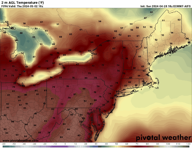
Thursday has the biggest question marks at this point. Some models indicate high pressure building in with some sunshine and warmer weather return. Other models have the backdoor cold front stay to our south with much cooler weather and possibly another round of showers as another weak disturbance moves through. Friday looks to be a dry day, but once again temperatures will be dependent on the position of that backdoor cold front. If the front stays to our north, we could end up much milder than what our forecast shows. Another system will move in from the west next weekend with a period of showers likely, mainly late Saturday into early Sunday. Temperatures both days will be dependent on when the rain both moves in and moves out, but will likely end up close to or a little below where we should be in early May.
Monday: Sunshine and some afternoon clouds. High 60-67 along the coast, 68-75 inland.
Monday night: Becoming partly to mostly cloudy, slight chance for a shower. Low 44-51.
Tuesday: Mostly cloudy. High 53-60 coolest along the coast, possibly even cooler from the North Shore to the New Hampshire Seacoast.
Tuesday night: Cloudy with some showers likely. Low 41-48.
Wednesday: Mostly cloudy, showers ending in the morning. High 50-57, coolest along the coast.
Thursday: Partly sunny, slight chance for a shower. High 63-70, cooler along the coast.
Friday: Partly sunny. High 62-69, cooler along the coast.
Saturday: More clouds than sun with some showers possible, especially late in the day. High 60-67.
Sunday: Partly to mostly cloudy with a chance for some showers. High 58-65.
