Hot Hot Hot. Buster Poindexter’s song is also for the forecast for the next few days.
Showers and thunderstorms will end this evening as a frontal system pushes offshore, then skies clear out overnight. Drier air settles in for Friday and Saturday, with dewpoints in the 50s Friday and 60s Saturday, but it will remain hot, with temperatures well into the 90s in many locations. Sunday is shaping up to be a rather hot and humid day as another frontal system approaches the region. Temperatures should be well into the 90s again with high to oppressive humidity. Some models are showing the potential for triple-digit temperatures north and west of Boston, especially from the Merrimack Valley into southern New Hampshire. We’re not sure it gets quite that hot, but upper 90s are a distinct possibility. Some showers and thunderstorms are likely late Sunday night, and again on Monday as another frontal system crosses the region. Humidity levels will start dropping again later on Monday, but it will remain warm, with highs well into the 80s, and some places could top 90 once again.
If you’re curious about the record highs for Sunday and whether some could be broken, here are the current records for some selected cities across the region:
- Blue Hill – 96 (1987)
- Boston – 98 (1933)
- Brockton – 97 (1987)
- Concord, NH – 100 (1870)
- Hyannis – 93 (1952)
- Keene, NH – 95 (1910)
- Lowell – 98 (1963 and 1987)
- Manchester, NH – 95 (2001)
- Nashua, NH – 100 (1952)
- Newburyport – 96 (2002)
- Portsmouth, NH – 95 (1987)
- Providence, RI – 94 (1987)
- Reading – 99 (2016)
- Woonsocket, RI – 95 (2016)
- Worcester – 94 (1910)
Thursday night: Showers and thunderstorms ending then skies clear out. Low 67-74.
Friday: Plenty of sunshine, not as humid. High 89-96, cooler right at the coast. Offshore: Small Craft Advisory for the South Coast. West winds 5-10 knots, becoming southwest 10-15 knots in the afternoon, seas 3-5 feet, a little higher off the South Coast, visibility under 1 mile in morning fog, improving in the afternoon.
Friday night: Clear skies. Low 66-73.
Saturday: Sunshine and a few clouds. High 89-96, cooler right at the coast. Offshore: Southwest 5-10 knots in the afternoon, seas 2-4 feet, visibility under 1 mile in morning fog, improving in the afternoon.
Saturday night: Clear to partly cloudy. Low 68-75.
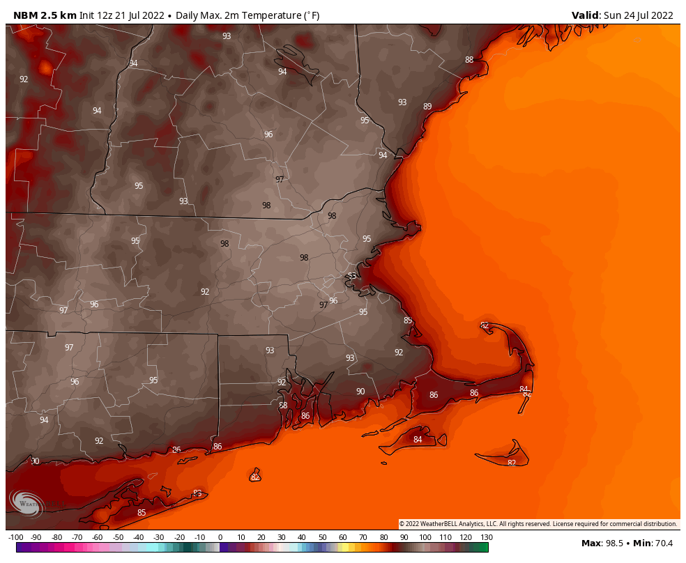
Sunday: A mix of sun and clouds, humid. High 93-100. Offshore: Southwest winds 10-15 knots, gusting to 25 knots, seas 2-4 feet, visibility 10 miles or better.
Sunday night: Partly to mostly cloudy with some showers and thunderstorms possible. Low 70-77.
Monday: Intervals of clouds and sun with additional showers and thunderstorms, especially during the afternoon. High 84-91. Offshore: Small Craft Advisory likely. Southwest winds 10-20 knots, gusting to 25 knots, season 3-6 feet, visibility 1-3 miles in showers and thunderstorms.
