This week will feature a little bit of everything, at least in terms of summer weather.

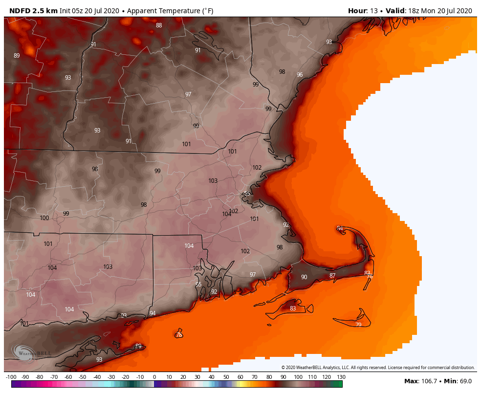
We start the week off with more heat and humidity today. Offshore high pressure continues to pump hot and humid weather in, and as a result, Heat Advisories remain in effect for a large portion of the region. Highs will get into the 90s again for much of the area today, with dewpoints in the upper 60s to middle 70s. That combination of heat and humidity will make it feel like its 100 or higher during the afternoon. Relief is on the way though, as a cold front will move across the region later today. This front may produce some showers and thunderstorms, but we’re not that confident that we’ll see widespread activity. Any storms that do form may produce heavy downpours and strong winds, but a severe weather outbreak doesn’t look likely at this point.
The front moves offshore tonight, and “cooler” and “drier” air settles in for Tuesday. While it won’t exactly be a lot cooler or a lot drier, it will still be more comfortable compared to today. Our respite doesn’t last long though as a warm front approaches on Wednesday. While the front may produce a few showers or thunderstorms, the more noticeable impact will be to bring the humidity back in. It’ll be quite warm as well, but cloud cover will prevent us from getting too hot once again.
Another cold front approaches on Thursday, with more showers and thunderstorms expected. Again, some of them could be quite strong, but a widespread severe weather event doesn’t appear likely at this time. Much cooler and drier weather does finally move in behind this front for Friday and Saturday. As for next Sunday, that’s a bit of a question mark at this point. Most of the models show a storm system passing to the north, but that’s where the similarities end and the story of Goldilocks and the Three Bears starts. One model has little to no precipitation, with hot and humid conditions. Another has it warm but dry with precipitation moving in at night. A third model has it cloudy and mild with showers during the afternoon. We’re going to play the middle ground right now, knowing full well that we’ve got plenty of time for the models to find some common ground and decide on a solution before we issue our Weekend Outlook Thursday afternoon.

Monday: Some dense fog along the South Coast early, otherwise a mix of sun and clouds with some showers and thunderstorms developing during the afternoon. A few of the storms may produce gusty winds and heavy downpours. High 89-96, cooler right along the South Coast. Heat indices could reach as high as 104 in some spots.
Monday night: Clearing and less humid. Low 65-72.
Tuesday: Sunshine and a few clouds. High 85-92.
Tuesday night: Clear to partly cloudy. Low 63-70.
Wednesday: Partly sunny and humid with some afternoon and evening showers and thunderstorms possible. High 82-89, cooler along the coast.
Thursday: Intervals of clouds and sun with some showers and thunderstorms during the afternoon and evening, breezy. High 82-89.
Friday: Partly to mostly sunny and drier. High 77-84.
Saturday: Sunshine and some high clouds. High 80-87.
Sunday: More clouds than sun with showers and thunderstorms possible late in the day and at night. High 83-90.
