We’ve got a nor’easter with a name heading our way, but the bigger story will be unfolding in the Caribbean over the next few days, as yet another hurricane takes aim on the islands.

With Irma dissipating over land a few days ago, Jose was the only active tropical system in the Atlantic for a few days, and thus grabbed most of the attention while it did a little loop a few hundred miles east of the Bahamas. It weakened to a tropical storm, but has since become a hurricane again. As of 5pm Saturday, it was centered a little less than 500 miles south-southeast of Cape Hatteras, NC with maximum sustained winds near 80 mph. It was moving towards the north at about 6 mph. The forecast for Jose for the next 48 hours is fairly easy. It will continue to head northward around the edge of a large high pressure area. While it remains over very warm water, there is still plenty of wind shear aloft, and the wind shear will counteract the warm water, preventing much, if any, additional intensification. It will produce rough seas for much of the western Atlantic, and also create a high risk of rip currents from New England to the Carolinas.
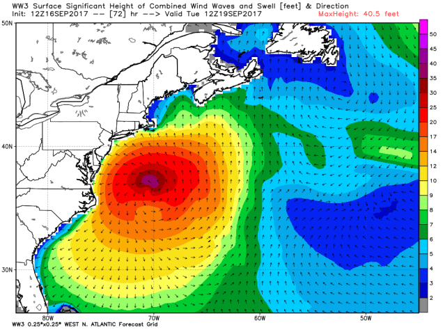
By Tuesday, Jose will start to move over colder waters as it passes north of the Gulf Stream, so it should start to weaken. At the same time, it will start to encounter westerly winds aloft, which will turn it more towards the northeast and eventually east. On this track, the center should pass about 100 to 150 miles south and east of Cape Cod as a weakening tropical storm. By this point, the storm may not even be completely tropical any more, and starting the transition into an extratropical system. It will pass close enough to bring gusty winds and some rainfall into southeastern portions of New England, but the impacts will be similar to a fall nor’easter, with temperatures in the 60s not the 40s (or colder). The biggest impacts will be across Cape Cod, where some wind gusts in excess of 60 mph are possible. Coastal flooding will also be an issue, as tides are running high this week with the New Moon on Wednesday. Rainfall totals of 1-3 inches and locally heavier shouldn’t cause any flooding issues, and will actually be beneficial, as some parts of the region have been dry lately, with some drought conditions starting to reappear. In other words, don’t freak out, we’ll probably have worse storms to deal with later this fall or winter, especially since many of those will have the dreaded s-word involved.

Well out in the Atlantic is Tropical Storm Lee. As of 5pm Saturday, Lee was centered about 720 miles west-southwest of the Cape Verde Islands, moving towards the west at 10 mph. Lee has maximum sustained winds near 40 mph. Lee is expected to continue on a general west to west-northwest track for the next few days. While some modest strengthening is possible over the next day or two, the long-term outlook is for Lee to weaken by early next week, and probably dissipate over the open waters of the central Atlantic, well away from any land areas.

While Jose has been grabbing the headlines, and Lee remains weak, Tropical Storm Maria has formed east of the Lesser Antilles, and this storm will likely grab most of the attention over the next few days, especially after Jose starts to move away from the East Coast.
Tropical Storm Maria formed Saturday afternoon east of the Lesser Antilles. As of 5pm Saturday, it was centered about 620 miles east-southeast of the Lesser Antilles, moving towards the west at 20 mph. Maximum sustained winds are near 50 mph, and additional strengthening is expected. Maria could become a hurricane on Sunday. A hurricane watch has already been issued for the islands of Antigua, Barbuda, St. Kitts, Nevis, and Montserrat, with a tropical storm watch in effect for the islands of St. Lucia, Martinique, Guadeloupe, Dominica, Barbados, St. Vincent, and the Grenadines. Additional watches and warnings are likely to be issued tonight and Sunday.

Maria is expected to cross the Lesser Antilles as a hurricane on Monday. It should pass farther south than Irma, which will spare the islands that were devastated from another direct hit. Once it gets past the Antilles, it will turn more towards the northwest, and head towards the Virgin Islands and Puerto Rico for Tuesday into Wednesday. It could become a strong hurricane by this point, so residents on this region, still trying to cleanup after Irma, need to play close attention to Maria. While Irma delivered a heavy blow to much of the British and US Virgin Islands, it did not do as much damage on St. Croix, the southernmost and largest island of the chain. If Maria does in fact track farther south than Irma did, then St. Croix could conceivably get hit harder than the rest of the Virgin Islands. This will be something to pay attention to in the next few days.
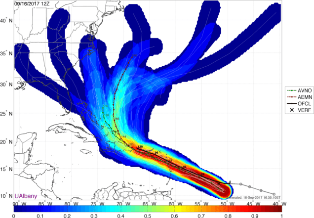
What about Maria’s future beyond mid-week? Well, at this point, almost anything is possible. As you can see from the GFS Ensemble plot above, it could continue northwestward towards Florida, turn more toward the north and potentially be a threat to the East Coast, or turn more towards the northeast and head out to sea. We won’t have a better idea about that until the middle of the upcoming week, if not later. To quote a friend of the blog when asked about Maria’s future:
“It’s way, way, way too early to even conjecture on that. Let’s just say, given the pattern, that folks on the East Coast shouldn’t just hit the snooze button once Jose departs.”
That’s probably the best advice we could give you right now as well.

One thought on “A “Nor’easter With a Name” Heads Our Way, While Maria Threatens the Caribbean”