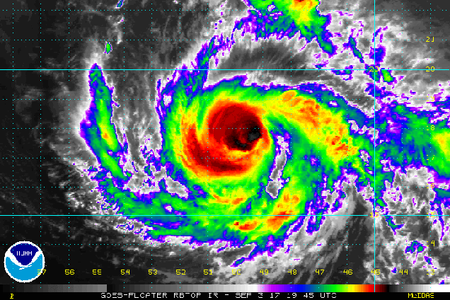
Before we get to the week ahead, we’ll address Irma, since we’ve been getting questions about it already. As of 11pm Sunday, Irma was centered a little more than 700 miles east of the Leeward Islands with maximum sustained winds near 115 mph. It is moving towards the west-southwest at 14 mph. Hurricane Watches have been posted for the islands in the northeastern Caribbean. Irma will turn more towards the west and west-northwest over the next few days, with some fluctuations in intensity. It will pass very close to the islands of the northeastern Caribbean on Tuesday, then likely pass just north of Puerto Rico and the Virgin Islands, before setting its sights on the southeastern Bahamas later this week. Beyond that? Well, that’s a question that really can’t be answered yet. The computer models, which can be notoriously bad more than a couple of days out, are all over the place. Just based on these, landfall, could occur anywhere between New Orleans and Nova Scotia, or not at all. It will be a few more days at least before we start to have any clarity on whether the storm will impact the United States or not. If it were, it wouldn’t happen until early next week anyway. We’ll likely have a special post about Irma later this week, where we take a deeper dive into the storm. For now, just keep an eye on it, especially if you live near the coast.

As for what will happen up here, we’ve got a spectacular Labor Day coming up. As we read the traditional end of summer, it will certainly feel likely summer today with sunshine and warm temperatures. Tuesday will likely end up as another warm day, but the sunshine will disappear early behind increasing clouds. The more sunshine that we get, the warmer it will be. A cold front will slowly approaches the region, and may end stall out across the area. As a result, we’re looking at an extended period of wet weather starting late Tuesday or Tuesday night, going right into Thursday or perhaps even much of Friday. It’s not going to be raining the entire time, in fact, there may be extended stretches of time where it’s not raining, but for the most part, it will be cloudy, cooler, and damp, with occasional rain and thunderstorms. Some of the rain will be heavy, which is actually good news, since parts of the region are starting to slip back towards drought conditions. Once this front finally moves out on Friday, high pressure builds in next weekend with sunshine and milder conditions.

Labor Day: Sunshine and a few clouds. High 76-83.
Monday night: Mostly clear with some high clouds moving in late at night. Low 61-68.
Tuesday: Some early sunshine, then clouds thicken up. Showers and thunderstorms may develop late in the day, mainly north and west of Boston. Breezy. High 80-87.
Tuesday night: Showers gradually spread across the region. Low 62-69.
Wednesday: Cloudy with occasional showers and a few thunderstorms. High 70-77.
Thursday: Cloudy with more showers and drizzle expected. High 67-74.
Friday: More clouds than sun, some lingering showers, especially south of Boston. High 67-74.
Saturday: Plenty of sunshine. High 64-71.
Sunday: Mostly sunny. High 67-74.
