Ready for another quiet week weather-wise? You must be in San Diego then, because this week certainly won’t be quiet around here.
The week starts off with high pressure over Atlantic Canada. The southeast to south flow around this high pressure area will keep plenty of moisture in place, resulting in some dense fog to start the day in parts of the region. The fog will burn off, but clouds will dominate the day with only a few sunny breaks as some of the moisture from Jose streams northward into the region. That brings us to Jose, and what it will do.

A Tropical Storm Watch is in effect for the East Coast from Fenwick Island, Delaware, northward to Plymouth, Massachusetts. Although Jose remains a hurricane now, it will weaken to a tropical storm as it heads northward in between Bermuda and the East Coast. Although there are still a few forecast models that bring the center of the storm very close to, if not right across, the south coast of New England, the more likely scenario is for the storm to make a right turn, and pass south and east of the area. It will still be close enough to spread in some locally heavy rain, with gusty winds along the coast as well. As we talked about in our blog post on Saturday, this is basically a “nor’easter with a name.” The rain will move into the region on Tuesday, with the heaviest rain and strongest winds likely Tuesday night into Wednesday, mainly across southeastern Massachusetts and Cape Cod. There will still be some locally heavier showers farther inland, and winds may occasionally be gusty, with the biggest impact from the storm will basically be south and east of I-95. Along the coast, we may also have to deal with some coastal flooding, as the persistent east to northeast winds will create some big waves, plus tides are running high this week thanks to a New Moon on Wednesday. Despite all of this, this storm is not going to be anything remotely resembling Harvey or Irma. We have said this a few times already, but we’ll say it again, just because it has a name, does not make it that big of a deal. We get storms that hit us harder nearly every fall and winter.

Thursday and Friday are where things start to get to tricky around here. The trend in the models for the past few runs has been for the storm to slow down and slowly turn back toward the south once it gets past us. Given that the storm will be even weaker by then as it sits over the colder waters off of the coast, winds won’t be much of an issue, except across the Cape and Islands. However, if the storm does slow down or even stall, it will keep the clouds locked in for Thursday and Friday, as well as the threat for more rain, mainly across the Cape and southeastern Massachusetts. Of course, if the storm slows down or makes the turn a little farther away than currently expected, then we may see some improving conditions. No matter what happens Thursday and Friday, by next weekend, the storm pulls far enough away to allow high pressure to build back in with sunshine returning to the entire region.

Monday: Some patchy dense fog early, otherwise plenty of clouds with a few sunny breaks. A shower or two can’t be ruled out. High 69-76.
Monday night: Cloudy and becoming breezy with rain developing along the South Coast after midnight, gradually spreading northward. Low 59-66.
Tuesday: Windy along the coast, breezy elsewhere with periods of rain and showers, possibly heavy at times along the South Coast and across the Cape. High 64-71.
Tuesday night: Windy, especially along the coast, with periods of rain, heavy at times, especially south of Boston. Low 60-67.
Wednesday: Windy along the coast, breezy elsewhere with periods of rain and showers, heavy at times along the South Coast and across the Cape. High 65-72.
Thursday: Mostly cloudy, still breezy across the Cape. Chance for more rain and showers, mainly across Cape Cod and southeastern Massachusetts. High 63-70 along the coast and south of Boston, 70-77 elsewhere.
Friday: Plenty of clouds with some sunny breaks, especially north and west of Boston. Some additional showers are still possible across Cape Cod. High 61-68 along the coast and south of Boston, 68-75 elsewhere.
Saturday: Becoming partly to mostly sunny, though clouds may be slow to move out across Cape Cod. High 74-81, cooler along the coast and across Cape Cod.
Sunday: Plenty of sunshine. High 78-85.
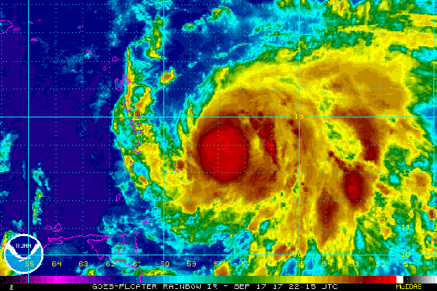
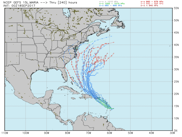
Finally, we’ll talk about Hurricane Maria. Maria will move across the Leeward Islands today, a little south of where Irma went across. As of early Monday morning, Maria had maximum sustained winds of 90 mph, and more strengthening is expected. Maria could become a Category 3 hurricane before crossing the islands. Once it crosses the Leeward Islands, it will turn a bit more toward the northwest. On this track, it will likely pass very close to St. Croix, and near or across Puerto Rico., possibly as a Category 3 or 4 Hurricane While St. Croix fared better than most of the other Virgin Islands during Irma, this is a region that does not need another major storm moving through. Once it gets past Puerto Rico and the Virgin Islands, there is a chance it could threaten the East Coast. Any potential impacts would be at least a week away at this point, so it’s not worth worrying about for now. However, we figured it was at least worth mentioning that after Jose passes by, not to let your guard down. We’ll keep tabs on Maria’s progress, and if the threat does materialize, we’ll let you know.