Mid-September is the peak of hurricane season in the Atlantic, and although things seemed a bit more quiet after Irma finally dissipated, that’s about to change again. We’ve got two active tropical systems in the Atlantic right now, and possibly a third one on the way. Bond villain Elliot Carver’s line from “Tomorrow Never Dies” seemed appropriate tonight.
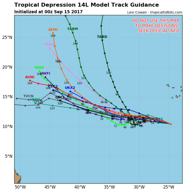
We’ll start by talking about newly-formed Tropical Depression 14. (We’re saving the best for last – we’ve got to keep you reading somehow). It developed late Thursday evening about 380 miles south-southwest of the Cape Verde Islands. It’s got maximum sustained winds near 35 mph, and is scooting along towards the west-northwest at 22 mph. The system is expected to strengthen into a tropical storm over the next day or so, and could even become a hurricane this weekend. A general west-northwest to northwest track is expected for the next 3-5 days, before it turns more toward the north-northwest. Meteorologists like to refer to a storm like this as a “fish storm”, because aside from the fish, it won’t really impact anyone else.
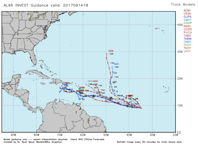
Another disturbance is located in the Central Atlantic, about 1200 miles east-southeast of the Lesser Antilles early this morning. (Don’t worry, we’re getting to the good part). Right now, it’s just a poorly organized cluster of thunderstorms, but conditions are favorable for it to become more organized over the next few days. It could become a tropical depression or a tropical storm by early next week. Right now, it looks like it could take a track towards the Lesser Antilles, but this is far from a given at the moment. Let’s wait to see if it even forms first, then we’ll worry about where it’s going.
Finally, we get to Tropical Storm Jose. You may remember earlier this week, when Jose was a Category 4 storm, and looked like it was going to hammer some of the same islands that Irma wiped out a week ago. Well, it turned just in time, sparing those islands for the most part. Jose then stalled out north of Puerto Rico and made an anti-cyclonic loop. Since it was sitting over the same general area of several days, it churned up the water pretty good, bringing the much cooler water down below to the top, and dispersing the warmer water that was there. This is called “upwelling.” Since tropical systems need to be over warm water to maintain their strength, when they sit for too long in the same location, they tend to weaken. Jose weakened from a storm that was on the cusp of Category 5 status with maximum sustained winds near 155 mph last Friday, to a tropical storm with 70 mph winds early this morning.
Jose is likely to start moving towards the west and eventually northwest over the next few days. This will bring the storm back over warmer waters, and also move it away from the wind shear that has been tearing it apart, which will allow it to strengthen into a hurricane again. A large ridge of high pressure is in place across the Atlantic, and that will help to steer Jose through the weekend. Jose will move around the edge of the ridge, heading towards the northwest and eventually north, likely as a hurricane, this weekend. Since it’s been sitting over the open ocean for a while and will start heading towards the west and northwest, it will send some large swells towards the Bahamas, Bermuda, and the East Coast.

Once we get past the weekend, things get complicated. As you may recall, in our Weekly Outlook on Monday, we mentioned that a few of the models showed a potential threat from Jose next week, but that the threat was very low. Well, it’s not quite so low any more. If you had asked us on Monday what the odds were of a direct impact, we’d have probably said 1 in 50, or about 2%. Now? We’ll call it 1 in 6, or about 15%. In other words, it’s still a low threat, but it’s certainly gotten our attention now. If you live near the South Coast or Cape Cod, it should probably have your attention too. So what has changed? Most of the models have shifted westward with their tracks for Jose over the past few days. As you may recall, a similar shift occurred with Irma. Many models kept trying to bring Irma up the East Coast, and even a day or two before landfall, many of them showed a track up the east side of Florida and into the Carolinas. With this westward shift, the models now bring the storm much closer to the East Coast. There are still plenty of them that keep it well offshore. Others keep it offshore, but close enough to bring some rain and strong winds into parts of southeastern New England. A few models bring the storm right across the region, likely in a much-weakened state. Then there’s a couple of models that are just completely insane. One model has Jose hit New England as a weak hurricane, move offshore, loop around, then try to come back again as a weak nor’easter a couple of days later. What it does beyond that is even more insane, which is why we’re ignoring that model completely.


The timing on when this could possibly impact our area would be around Tuesday or Wednesday of next week. Obviously, things can and will change between now and then. We’ll keep a close eye on it. We’ll obviously detail it in our Weekly Outlook Monday morning, but if the threat increases more, we may have another blog post this weekend about the storm.
For those interested, the Atlantic isn’t the only active area right now. Tropical Storm Norma could become a hurricane before heading towards Mexico’s Baja peninsula. Tropical Depression 15-E could become a tropical storm but remain over open waters in the Eastern Pacific. Typhoon Doksuri is making landfall in Vietnam, and Typhoon Talim will make landfall in southwestern Japan this weekend. Yeah, things are a little busy right now.
