We got the snow, now we’ve got the cold. As many of you are reading this, temperatures are near or below zero, thanks to arctic air and fresh snow cover. Don’t worry, it won’t last long. In fact, for a portion of the upcoming week, temperatures will actually be above normal. Combine mild temperatures with rainfall and the snow that’s on the ground won’t last that long.
The week starts off with high pressure giving us a frigid day on Monday. Many places may not reach 20 degrees in the afternoon. Clouds will stream in late in the day ahead of the next storm system.That storm will pass well to our north and west by midweek, and while that means it will be mostly rain, it won’t be all rain. As the moisture moves in on Tuesday, it will still be fairly cold, so it will likely start as some snow Tuesday afternoon. The warmer air will move in aloft first, which means that we’ll go over the freezing rain or sleet for a while Tuesday evening and night, and eventually plain rain by early Wednesday. The rain will taper off and end later on Wednesday, but we’ll actually stay mild, as another storm rides along a front towards the Great Lakes. That system passes to our north and west later Thursday and early Friday, with plenty of clouds and a few showers likely. It will be quite mild though. We wouldn’t be surprised at all if some places made a run at 60 degrees either Thursday or Friday. A cold front moves through on Friday, ushering colder air back into the region. High pressure builds in for Saturday with another cold day expected. Another weak system passes by to the south for Saturday night and Sunday, which may spread in some snow showers across southern areas. For now, it doesn’t look like a big deal, but we’ll keep an eye on it for you, because we know that a lot of you are interested in the forecast for Saturday night (more on that at the bottom).
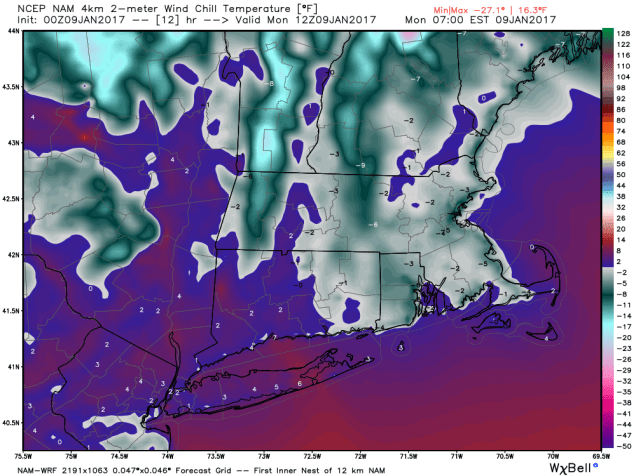
Monday: Sunny and frigid, clouds start to filter in late in the day. High 15-22.
Monday night: Partly to mostly cloudy. Low 8-15.
Tuesday: Cloudy with snow developing in the afternoon, quickly changing to rain from Boston southward. High 34-41.
Tuesday night: Snow changes to freezing rain and eventually plain across north and west of Boston, showers likely elsewhere. Low 30-37 in the evening, then temperatures slowly rise overnight.
Wednesday: Showers taper off and end. A few sunny breaks are possible late in the day. High 44-51.
Thursday: Mostly cloudy and breezy with a few showers possible. High 50-57.
Friday: Plenty of clouds, breezy and mild, chance for a few showers. High 48-55.
Saturday: A mix of sun and clouds, much colder, some light snow is possible at night. High 28-35.
Sunday: Partly to mostly cloudy with some light snow or snow showers possible. High 30-37.
Foxborough Forecast:
Saturday evening at Gillette Stadium will feature partly to mostly cloudy skies and light winds, with temperatures starting in the middle 20s, and dropping into the lower 20s by the end of the game. There is a chance for some light snow, but it’s more likely that there won’t be any at this point. Patriots 31 Texans 10
