The week won’t be completely quiet, but dry weather is expected for Red Sox Opening Day on Thursday.
The week starts off with high pressure moving offshore, allowing for a dry day today, but clouds will be on the increase ahead of a weak storm system. That system will pass south of the region tonight, with some rain showers likely, possibly mixed with a little snow, especially across the hills and into southern New Hampshire and the Merrimack Valley. Skies will be slow to clear out on Tuesday behind the system with an upper-level disturbance moving through, possibly producing another shower or two. High pressure builds in for Tuesday night and Wednesday with clearing skies and seasonable temperatures. A cold front moves through Wednesday night or early Thursday with a few rain or snow showers likely.
Tonight’s system should be mostly rain, but some wet snow is possible. Loop provided by WeatherBell.
For Red Sox Opening Day on Thursday, skies should become partly to mostly sunny, but it will be on the breezy and cool side. For first pitch a little after 2pm, it will only be around 42 degrees, but when you factor in the northwest winds at 10-20 mph gusting to 30 mph, it will feel like it’s only in the lower to middle 30s.
It may not feel like baseball weather on Thursday, but it’s another sign that Spring has arrived.
Friday will turn warmer as winds shift into the southwest, but clouds will be on the increase again ahead of the next storm system. The details are still a little fuzzy on this one, but for now, it looks like we’ll have periods of rain at some point between Friday night and Sunday, though it could start and/or end as snow across southern New Hampshire and the Worcester Hills. As for temperatures, the models all show a warm front moving in, but how far north it gets is up for debate. South of the front, temperatures could climb into the 60s, north of it, they may stay in the 40s (or 30s). We should have more clarity when it’s time for our Weekend outlook on Thursday.
The models vary by 20-30 degrees on temperatures for Saturday afternoon. Images provided by Pivotal Weather.
Monday: Morning sunshine, increasing and thickening clouds in the afternoon, showers develop late in the day. High 50-57.
Monday night: Cloudy with some light rain and showers likely, possibly mixed with wet snow before ending. Low 31-38.
Tuesday: Clouds and some afternoon sunny breaks, a shower or two is possible. High 41-48.
Tuesday night: Partly cloudy. Low 26-33.
Wednesday: Sunshine and a few clouds, chance for a rain or snow shower at night. High 46-53.
Thursday: Mostly sunny and breezy. High 40-47.
Friday: Mostly cloudy and breezy, showers developing at night. High 45-52.
Saturday: Mostly cloudy and windy with rain likely. High 59-66, potentially much cooler north of the Mass Pike.
Sunday: Early showers, then becoming partly sunny and breezy. High 43-50.
Spring begins today, and we’ve got some nice weather for a few days, but the latter half of the week may not be as nice.
Tuesday is the pick of the week with sunshine and temperatures possibly making a run at 60. Image provided by WeatherBell.
High pressure will be in control through Wednesday with dry weather and a warming trend expected. It’ll still be breezy today, but winds should diminish into Tuesday. Clouds will start to increase on Wednesday ahead of a warm front. That front will produce some showers Wednesday night into early Thursday, setting up a very mild day, with some showers possible. The front will sag southward as a cold front late in the day, likely stalling out near or just south of New England. Another wave of low pressure rides along that front on Friday with some additional showers likely, depending on where the front stalls out. With some cooler air in place, we could see some wet snow mix in across northern Massachusetts and southern New Hampshire if the front does stay out near the South Coast, but these are the types of details that are kind of fuzzy this far out, and will need to be fine-tuned later this week. Another low pressure likely moves up the St. Lawrence Valley over the weekend with a secondary low pressure system passing south of New England, but the details regarding timing and precipitation type with this system vary depending on which model you look at.
Saturday may not be a great day around here. Images provided by Pivotal Weather.
Monday: Wall-to-wall sunshine, breezy. High 45-52.
Monday night: Clear to partly cloudy. Low 25-32.
Tuesday: A mix of sun and clouds, breezy during the afternoon. High 53-60.
Tuesday night: Partly cloudy. Low 29-36.
Wednesday: Some morning sun, then becoming mostly cloudy with showers possible at night. High 51-58, cooler at the coast.
Thursday: Cloudy and breezy with a few showers early, then becoming more numerous late in the day and into the evening. High 52-59.
Friday: Cloudy, more showers possible, breezy. High 48-55.
Saturday: Cloudy and breezy with a chance of rain or possibly snow, especially north and west of Boston. High 40-47.
Sunday: More clouds than sun with a chance for showers early, breezy. High 44-51.
As Metallica sings in the beginning of the song “All Nightmare Long”, luck does indeed run out. After getting lucky for nearly the entire winter without a major snowstorm, it appears that our luck has finally run out.
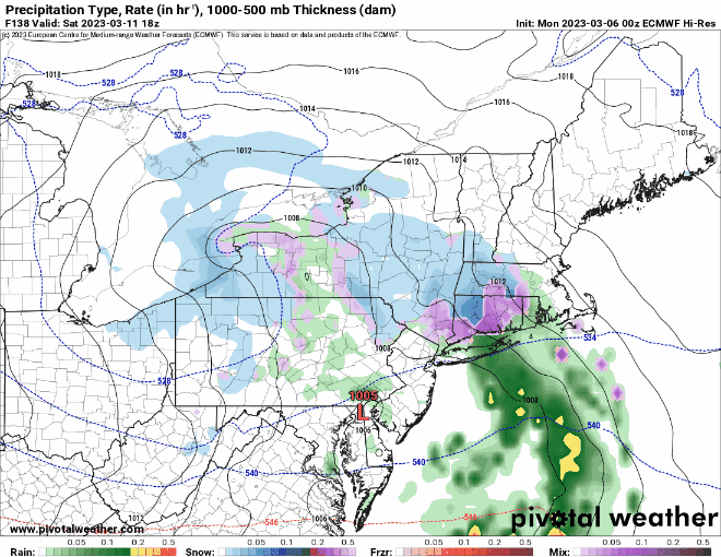
Today will be the literal calm before the storm with high pressure sliding off to the east, but still keep us dry despite plenty of cloudcover. After that, we turn our eyes to a developing low pressure system moving up the East Coast. This will likely be a potent storm when it gets up here, producing strong winds and quite a bit of precipitation. It’s also expected to stall out and perhaps make a bit of a loop, which means we’re looking at a long-duration storm, starting this evening, and likely not ending until Wednesday morning. That’s what we’re fairly certain about. What we’re not certain about is the actually track the storm takes, and where it stalls/makes a loop, and that is the most critical part of the forecast. Temperatures will be marginal to begin with, so a degree or two will make a huge difference. We’re not worried about any warm air aloft, so sleet and freezing rain aren’t a concern – just a good old-fashioned rain/snow line. With marginal temperatures, intensity will also help determine what falls, as lighter precipitation will be more rain than snow, while heavier precipitation will bring some colder air down from aloft, resulting in more snow than rain.
Whether it’s rain or melted snow, this will be a rather juicy storm. Image provided by WeatherBell.
OK, having said all that, he’s our best estimate as to what we expect – low pressure moves up the East Coast, passing just south and east of Cape Cod. Meanwhile, a much weaker secondary low will move across Long Island and southern Connecticut, before it weakens and dissipates. This will help keep temperatures a little warmer, especially near the South Coast, with east to southeast winds. The original rather potent system will then do a loop in the waters just east of New England, before finally moving away on Wednesday. In terms of sensible weather we’re probably looking at nearly all snow north of the Mass Pike and outside of I-495, especially in the hills. South and east of there, precipitation likely starts as rain this evening, gradually changing to snow from northwest to southeast during the day on Tuesday as the system moves off to the east, and strong north to northwest winds bring cooler air in. Those winds will gust to 40-50 mph at times, but luckily tides are astronomically low, so coastal flooding isn’t a widespread concern.
We think the forecast track on the NAM is close to what might happen. Loop provided by Tropical Tidbits.
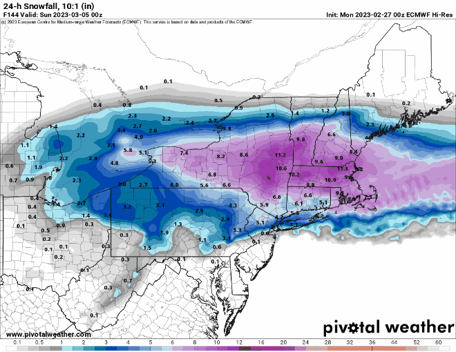
As for snowfall, we need to make a distinction here between snowfall and snow accumulation. With the increasing sun angle, and the warmer ground, snow will have a hard time accumulating during the daylight hours, especially on paved surfaces, when precipitation is falling lightly. So, it could snow for quite some time, but there won’t be much on the ground. The model forecast maps that people love to share on Facebook and Twitter show snowfall, and as we’ve just said, those maps will not be reflective of what you may see on the ground when this storm winds down. What are we expecting for accumulation?
0-2″ – Outer Cape/Islands 2-4″ – South Coast/Upper Cape/Coastal Plymouth County 4-7″ – I-95 corridor (Providence/Boston), southeastern Massachusetts/North Shore 5-9″ – Metro West/Essex County/NH Seacoast 6-12″ – Merrimack Valley/Southern New Hampshire 8-16″ – Hilly terrain from northwest Rhode Island into central Massachusetts and southwest New Hampshire with isolated heavier amounts possible.
We will note that there are some models that do bring heavier (in some cases MUCH heavier) snow into eastern and especially southeastern Massachusetts. We’re not putting much stock in those. However, if they do end up correct, our snowfall forecast will be off by several orders of magnitude.
Our forecast isn’t that different from what the National Weather Service is forecasting. Image provided by Weathermodels.com
Once this storm pulls away, high pressure builds in with drier and more seasonable conditions for Wednesday night and Thursday. Another system may move in later Friday into Saturday, but this looks like mainly rain, with drier weather again behind that storm on Sunday.
Monday: Mostly cloudy, breezy, showers developing late in the day. High 40-47.
Monday night: Windy with rain likely, changing to snow across southern New Hampshire and central Massachusetts toward daybreak, rain may be heavy at times. Low 32-39.
Tuesday: Windy with rain changing to snow from northwest to southeast during the day. Snow and rain could be heavy at times. High 33-40 early, temperatures hold steady or drop during the day.
Tuesday night: Windy with snow gradually tapering off. Low 27-34.
Wednesday: Mostly cloudy and windy, snow showers ending. High 33-40.
Thursday: A mix of sun and clouds, breezy. High 42-49.
Friday: Becoming mostly cloudy, breezy, showers develop at night. High 45-52.
Saturday: Mostly cloudy, breezy, showers likely, possibly changing to snow before ending at night. High 45-52.
Much of the upcoming week will feature quiet weather, a welcome change from the active pattern we’d had over the past few weeks.
Saturday’s storm produced light to moderate snow across much of the area. Image provided by the National Weather Service.
The week starts off with high pressure providing us sunshine and seasonable temperatures, but low pressure will continue to intensify in Atlantic Canada, producing gusty winds across the region for the next few days. A weak system will move out of the Great Lakes on Tuesday, likely passing south and west of the region, but it may be close enough for a few rain or snow showers. Wednesday and Thursday will feature intervals of clouds and sunshine with a few rain or snow showers along with gusty winds as disturbances rotate around low pressure south of Nova Scotia. By Friday, high pressure builds in with more sunshine and lighter winds.
Normal high temperatures for early March are in the lower to middle 40s. Image provided by Weathermodels.com
Unfortunately, next weekend does not look as quiet. Most of the models are showing the potential for a storm system to impact the region next weekend, but they differ considerably on the details, including timing, placement, strength, and precipitation type. Hopefully, things will become clearer later this week.
The models all have different ideas for what will happen next Saturday, Images provided by Pivotal Weather.
Monday: Sunshine and some afternoon clouds, windy. High 41-48.
Monday night: Partly cloudy, breezy. Low 22-29.
Tuesday: Becoming partly to mostly cloudy, breezy, chance for a rain or snow shower. High 32-39.
Tuesday night: Partly cloudy, breezy. Low 22-29.
Wednesday: More clouds than sun, breezy, a rain or snow shower possible, mainly across Cape Cod. High 39-46.
Thursday: Partly to mostly cloudy, breezy, chance for a rain or snow shower, mainly near the coast. High 39-46.
Friday: Mostly sunny. High 40-47.
Saturday: Mostly cloudy, breezy, chance for snow or rain. High 38-45.
Sunday: Mostly cloudy, windy, chance for snow or rain. High 36-43.
Also, a remainder that Daylight Saving Time begins next Sunday at 2am, so you’ll lose an hour or sleep, or if you’ll be at work, you’ll have an hour less of work.
We’ve got a rather turbulent week coming up across the region.
High pressure will be in control to start the week, with a mostly dry Monday, but a storm system is on the way. Low pressure will cross the Great Lakes and head up the St. Lawrence Valley while weakening. Meanwhile, a secondary area of low pressure will develop off the Mid-Atlantic coast and head eastward. We’ll be in between the two, which means some light to perhaps moderate snow developing Monday night continuing into Tuesday. The Tuesday morning commute is going to be rough, so plan accordingly. As temperatures rise to near or above freezing, we may see a change to rain, especially across southeastern Massachusetts, possibly into the Boston area. So, the afternoon commute may not be as bad, especially south of Boston. The snow winds down during the evening. Despite earlier model predictions and internet hype, this will NOT be a big storm. In general, most of us will see 2-5″ of accumulation, perhaps a little less along the coast, perhaps a little more near the hills from northwestern Rhode Island into central Massachusetts and southwestern New Hampshire.
This will be a light to moderate snowstorm for the region. Image provided by WeatherBell.
Wednesday starts off dry, but another weak disturbance moves through late in the day with a few rain or snow showers possible. Another system quickly follows for Thursday, but this one looks warmer, as it will pass north of the region, so some rain showers are expected, maybe some freezing rain as you head up into central New Hampshire. That system moves offshore Thursday evening, then high pressure builds in, but it doesn’t hang around for too long. Yet another system quickly follows for late Friday into Saturday. There’s still plenty of uncertainty with this one, but it looks to pass near or just south of the region, so more snow is possible, or perhaps a mix of snow, sleet, and rain. Obviously, we’ll have a better idea of what this storm will bring (we hope), but the time we get around to our Weekend Outlook on Thursday. Yet another weak disturbance may bring in some snow showers Saturday night and early Sunday before high pressure builds back in.
The models have differing ideas on the potential for a storm late Friday and Saturday. Images provided by Pivotal Weather.
Monday: Morning sun, clouds return in the afternoon. High 30-37.
Monday night: Cloudy with snow developing. Low 21-28, temperatures may rise a little after midnight.
Tuesday: Breezy with snow likely, possibly mixing with rain south of Boston. High 33-40.
Tuesday night: Snow (or rain), ending in the evening, some clearing after midnight. Low 22-29.
Wednesday: Some morning sun, clouds move back in during the afternoon, snow or rain showers possible in the evening. High 40-47.
Thursday: Mostly cloudy, breezy, and mild with rain showers likely. High 46-53.
Friday: Mostly cloudy and breezy, snow, sleet, rain developing late in the day, becoming windy at night. High 35-42.
Saturday: Wintry mix ending in the morning, some sunny breaks in the afternoon, then some more snow showers possible at night, windy. High 32-39.
Sunday: Some morning snow showers, becoming partly sunny, breezy. High 34-41.
An active weather pattern will bring many changes to our weather this week.
We start off the week with a little rain across southeastern Massachusetts behind a departing disturbance. The rest of the day will be mild, but a cold front will swing through this afternoon with the chance for a few showers. We’ll clear out for a little while tonight behind that front, but clouds quickly return on Tuesday ahead of another disturbance. This one will bring in some more showers on Tuesday, but some snow could mix in, especially from the Merrimack Valley into southern and central New Hampshire. Accumulations won’t amount to much, but an inch or so is possible in southern New Hampshire. The real changes start on Wednesday.
A little bit of snow is possible Tuesday afternoon and evening. Image provided by WeatherBell.
A double-barreled low pressure will move out of the Great Lakes and head toward the region later Wednesday into Thursday and early Friday. This will bring a variety of weather in. Precipitation will move in late Wednesday afternoon and evening, and will likely start as snow for much of the region, with a wintry mix or rain likely near the South Coast. Warmer air will move in aloft, eventually changing the precipitation to sleet and freezing rain. A change to plain rain is likely near the South Coast, but temperatures may stay below freezing across much of the remainder of the region, with a prolonged period of sleet and/or freezing rain possible Wednesday night and early Thursday. We may get a bit of a break Thursday afternoon before the second part of the system moves in with more mixed precipitation Wednesday night into Thursday morning. There is the potential for several inches of snow before the changeover Wednesday night and Thursday morning, especially north of the Mass Pike, but this is highly uncertain at this point. Either way, the Thursday morning commute will be a mess.
The Thursday morning commute has the potential to be ugly around here. Images provided by Pivotal Weather.
High pressure builds in for late Friday and Saturday with some chilly weather, then another system quickly follows late Saturday into Sunday with a chance for some more light snow, possibly mixed with rain, especially near the South Coast.
Saturday morning could be rather chilly around here. Image provided by Weathermodels.com
Monday: Mostly cloudy, chance for a few showers during the afternoon, some late-day clearing, breezy. High 51-58.
Monday night: Partly cloudy through the evening, clouds move back in late at night. Low 27-34.
Tuesday: Cloudy and cooler with some rain or snow showers likely during the afternoon and evening. High 36-43.
Tuesday night: Clearing, breezy. Low 24-31.
Wednesday: Early sun, then clouds return, snow and sleet developing at night. High 37-44.
Thursday: Snow changing to sleet and freezing rain, plain rain south of Boston, breezy. High 25-32 north of the Mass Pike, 33-40 south of the Pike.
Friday: Snow, sleet, freezing rain, and rain ending early, some late-day clearing, windy. High 30-37.
Saturday: Partly sunny and chilly, clouds thicken up in the afternoon, light snow developing at night, mixed with rain near the South Coast. High 23-30.
Sunday: Snow or rain ending early, some late-day clearing, breezy. High 36-43.
We’ve got another fairly quiet week coming up with some rather mild weather on the way once again.
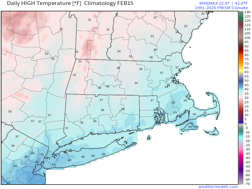
Normal high temperatures for mid-February are in the middle to upper 30s. Image provided by Weathermodels.com
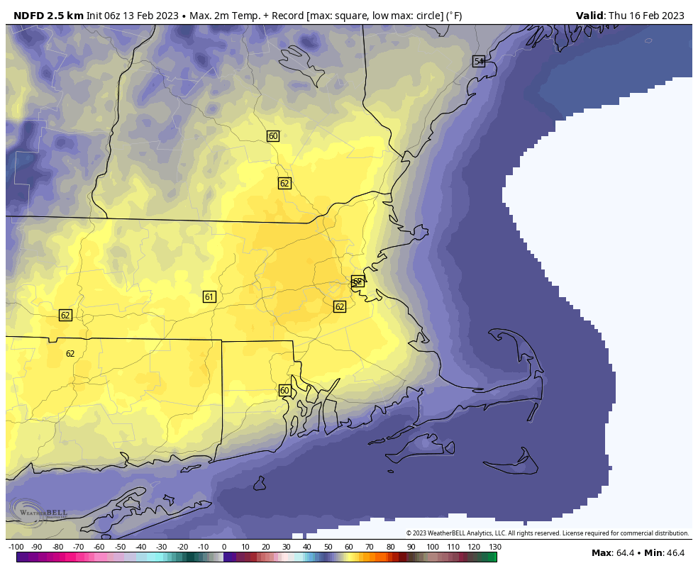
We start the week off with low pressure pulling away from the region. Any lingering showers across Cape Cod will end this morning, but skies will remain cloudy. An upper-level disturbance moves through tonight with more clouds, and possibly a few snow showers, mainly north of Route 2. High pressure then builds in for Tuesday with clearing and mild temperatures. The warming trend will continue for Wednesday and Thursday, with highs on Thursday possibly setting some records with temperatures topping 60 in some spots. Wednesday will remain dry, but some rain will develop later on Thursday as low pressure heads toward the St. Lawrence Valley. The rain will end on Friday as the system drags a strong cold front across the region. The timing of this front is a huge question mark right now, and that will have a significant impact on the temperature forecast. The later the front moves through, the more likely we have another warm day with more record highs possible. An earlier frontal passage results in a cooler day. Either way, high pressure builds in for the weekend with dry and much cooler conditions.
Record highs could be challenged across the region again on Thursday. Image provided by WeatherBell.
Monday: Mostly cloudy, any lingering showers near the South Coast and Cape Cod end in the morning. High 40-47.
Monday night: Partly to mostly cloudy, chance for a few snow showers or flurries, mainly north of Route 2. Low 28-35.
Tuesday: Becoming mostly sunny and breezy. High 42-49.
Tuesday night: Clear during the evening, then clouds increase once again. Low 26-33.
Wednesday: Intervals of clouds and sun, windy. High 49-56.
Thursday: Becoming mostly cloudy and breezy with showers likely late in the day and at night. High 58-65, cooler across the South Coast and Cape Cod.
Friday: Mostly cloudy with showers ending, some late-day clearing, windy. High 52-59, temperatures drop during the afternoon.
Saturday: Plenty of sunshine, breezy, and cooler. High 32-39.
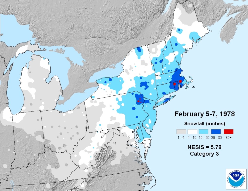
Today marks the 45th anniversary of the Blizzard of 1978. Nothing remotely similar is expected this week.
The Blizzard of 78 is still the storm that all snowstorms are compared to across this region. Image provided by NOAA.
We start the week off with a few showers across Cape Cod as low pressure passes well to the south of the region. Despite the cloudcover, and it’ll be another mild day. Tuesday will be a little cooler as high pressure builds in, but temperatures will remain above normal for early February. Another front approaches at night with some rain or snow showers possible. High pressure returns for Wednesday with dry and mild conditions once again. Another system moves in on Thursday with more rain, possibly starting as a little sleet or snow north and west of Boston. Friday looks to be quite mild with partial sunshine, but another system quickly follows for Friday night into early Saturday with more rain, possibly some snow well north and west of Boston. High pressure builds back in on Sunday.
Monday: More clouds than sun any lingering showers across the Cape and Islands end early, becoming breezy. High 43-50.
Monday night: Becoming clear to partly cloudy, breezy. Low 18-25.
Tuesday: Early sun, then clouds return. High 34-41.
Tuesday night: Cloudy with a few rain or snow showers possible during the evening, clearing late at night, breezy. Low 27-34.
Wednesday: Mostly sunny. High 44-51.
Thursday: Plenty of clouds with showers likely, possibly mixed with snow to start well north and west of Boston, breezy. High 44-51.
Friday: Partly sunny and breezy. High 50-57.
Saturday: Mostly cloudy, breezy. more showers, possibly mixed with snow, especially north and west of Boston. High 38-45.
Sunday: Plenty of sunshine, breezy again. High 33-40.
We’re deep into winter, but it hasn’t felt like it much for the past couple of months. That’s about to change, potentially in a big way.
The week starts off mild once again, but a cold front will move across the region later today and tonight. As the front moves through, some rain or snow showers are possible, with a few snow squalls not out of the question. High pressure builds in for Tuesday and Wednesday with drier weather and more seasonable temperatures. This will also help deflect a low pressure off to the south, which may actually bring some snow to the Mid-Atlantic states, though we could see some of the precipitation reach the South Coast. Another system passes south of the region on Thursday, spreading in more clouds, but we’ll also see temperatures start to moderate a bit. This sets the stage for what’s to come at the end of the week.
Some snow squalls are possible as a cold front moves through the region tonight. Loop provided by WeatherBell.
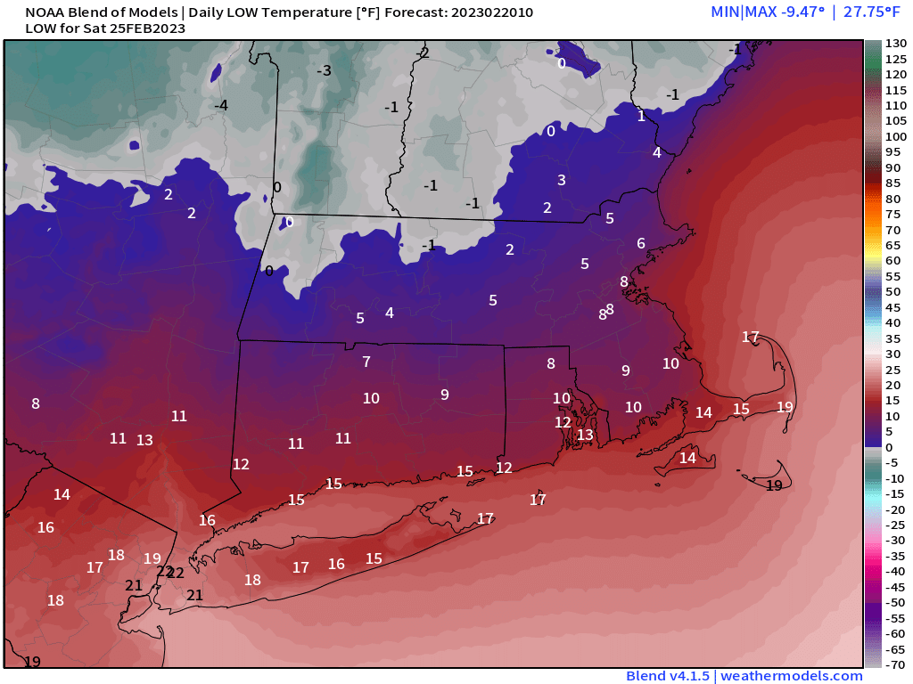
A strong cold front will cross the region Friday morning as a rather large high pressure system settles into southern Ontario. Behind the front, the coldest air we’ve seen in several years will pour into the region. Temperatures will likely start the day in the 30s, but will rapidly drop during the afternoon, likely reaching the single digits by evening, and dropping below zero across most of the region overnight. By Saturday morning, temperatures may be as cold as -10 to -15 north and west of Boston, with even colder temperatures possible. But wait, if that’s not cold enough, gusty northwest winds will create wind chills of -20 to -30. Saturday morning might be a good day to skip that morning run, or you’ll probably want to make sure the dog takes care of business quickly. Despite sunshine, temperatures likely stay in the single digits or lower teens during the daytime. As the high slides by to the north, winds may shift into the north or northeast, which could allow for some ocean-effect snow showers to develop across Cape Cod. As the high continues eastward, winds will shift into the southeast and eventually south, bringing a quick end to our arctic blast. Temperatures will continue to rise Saturday night, and should get well into the 30s and even 40s again across the region on Sunday.
No matter which model you look at the wind chills Saturday morning will be ridiculously cold. Images provided by Pivotal Weather.
We should also mention that Thursday is Groundhog Day. Tradition states that if the groundhog sees his shadow, then there will be 6 more weeks of winter. Have we really had winter yet? Not really, so the groundhog probably won’t see his shadow. Of course, if you trust a long-range forecast from a rodent, then can we interest you in investing in some quality swampland in Florida? Sunday however is National Weatherperson’s Day. Obviously, we like that one a little more.
Monday: Intervals of sun and clouds. High 43-50.
Monday night: Partly to mostly cloudy with a few rain or snow showers possible, maybe even some snow squalls that could drop a quick inch in spots. Low 26-33.
Tuesday: Partly sunny. High 31-38.
Tuesday night: Partly to mostly cloudy with a few snow showers possible. Low 14-21.
Wednesday: Sunshine and a few clouds. High 26-33.
Thursday: A mix of sun and clouds, breezy. High 33-40.
Friday: Partly to mostly sunny, windy, and turning sharply colder. High 21-28 in the morning, temperatures plunge in the afternoon.
Saturday: Plenty of sunshine, breezy, and bitterly cold, except for a few snow showers possible on Cape Cod. Morning low -1 to -8 south of the Mass Pike, -9 to -16 north of the Pike. High 6-13 during the evening.
Sunday: Mostly cloudy, windy, milder, chance for some snow or rain showers. High 35-42.
A fairly active weather pattern is on deck for this week, with several bouts of unsettled weather expected.
We’re starting the week off on a stormy note with low pressure passing south of the region. Colder air will work its way in behind the storm today, allowing the rain/snow line to move southward as the day progresses. So, even places that are still raining this morning will likely see some snow before the day is out and the storm pulls away. Areas south of the Mass Pike will likely see an inch or less of accumulation, with another 1-3 inches north of the Pike, and possibly a little more than that across southern New Hampshire. Everything ends this evening, then high pressure briefly builds in tomorrow with drier conditions.
Much of the region will only pickup another inch or two of snow today. Image provided by WeatherBell.
However, another storm will quickly follow for Wednesday. With some cold air in place, this one will likely start as snow across the region Wednesday afternoon, making for a rather messy afternoon commute. However, with the low passing west of us, and a secondary low pressure system developing right overhead, warmer air will move in, resulting in a change to rain Wednesday evening and night, ending Thursday morning. As that system pulls away, breezy and cooler conditions settle in late Thursday into Friday, but a cold front will approach the region on Saturday. That front may produce some snow showers Saturday afternoon and evening before it pushes offshore. Wel clear out behind it and turn colder, but yet another system quickly follows late Sunday, with some rain or snow showers possible late in the day ahead of a warm front.
Most of the models show snow falling for the Wednesday afternoon commute. Images provided by Pivotal Weather.
Monday: Breezy with snow likely north of the Mass Pike, rain changing to snow south of the Pike. High 34-41 early, temperatures drop during the afternoon.
Monday night: Snow ending in the evening, followed by clearing, windy. Low 22-29.
Tuesday: Morning clouds, some afternoon sun, breezy. High 35-42.
Tuesday night: Clear through the evening, clouds return after midnight. Low 17-24.
Wednesday: Cloudy with snow developing in the afternoon, changing to rain from south to north during the evening. High 32-39.
Thursday: Windy with periods of rain, ending in the afternoon. High 39-46 north and west of I-495, 47-54 south and east.
Friday: Partly to mostly sunny, breezy, and colder. High 32-39.
Saturday: Mostly cloudy and breezy with a few snow showers possible, clearing late in the day. High 37-44.
Sunday: Becoming mostly cloudy and breezy, snow or rain showers possible late in the day. High 35-42.