Plenty of Storms, Nearly All Threats to Land

There are currently 7 active tropical systems in the Atlantic and Pacific Ocean, and amazingly, 6 of them could be threats to land within the next 5 days.

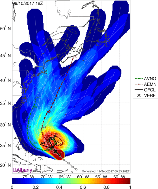
The storm that is rightfully gaining the most attention (and hype) is Hurricane Florence. As of early Tuesday afternoon, Florence was centered about 370 miles south-southwest of Bermuda, moving toward the west-northwest at 17 mph. Florence reached Category 4 strength Monday evening, before undergoing and eyewall replacement cycle. What that means is that the intense thunderstorms surrounding the eye of the storm essentially weaken, but a new ring of storms forms farther away from the center. These eventually contract to form a new eyewall. While this will weaken a storm a bit, it also expands the radius of the wind field. Now that Florence has undergone this process (which will likely happen again at some point in the next day or two), its maximum sustained winds have decreased to around 130 mph, making it a Category 3 hurricane. A Hurricane Watch and Storm Surge Watch have been issued for most of the coastline of North Carolina and South Carolina.

atcf_AL06_current
This probably isn’t a good time for a trip to the Outer Banks. Image provided by WeatherBell.

Florence is expected to continue in a general west-northwest direction for the next day or two, with some additional strengthening expected. It should regain Category 4 status later today, and there is a chance it could reach Category 5, depending on when the next eyewall replacement cycle takes place. By Thursday, high pressure will build in north of Florence, which will start to slow the system down as it approaches the North Carolina coastline.

GFS 50-STATES USA North Carolina Total Precipitation 144
That’s a lot of rain, and the scary part is, this might be an underestimate. There’s going to be a LOT of flooding, even well inland. Image provided by Weathermodels.com

Most of the forecast models show the system slowing to a crawl or even stalling out by Friday. The big question is, does it stall out before landfall or after landfall? No matter where it stalls, many of the effects will be the same, it will just determine what happens down the road. The strongest winds will be confined to areas closest to the coastline. Once the storm stalls out, especially if it is over land, it will start to weaken, with winds becoming less of a problem, especially the farther away from the center you area. Storm surge will also be a major problem, especially across the Outer Banks and Pamlico and Albemarle Sounds, but again, once the storm is weakening (and likely inland), the storm surge threat starts to decrease. By far, rainfall and resultant flooding is the largest threat. Tropical systems already produce copious rainfall, but when they stall out, the amounts become that much higher – just look at what Hurricane Harvey did to Texas last year. In this case, with the storm expected to sit near or over the Carolinas for a few days, we could be looking at rainfall totals of 15-30 inches or more, which could lead to some of the worst flooding the region has ever seen. The torrential rain will also spread into neighboring parts of Virginia as well. Beyond that, we’ll have to see where the storm actually goes before we can tell if the heavy rain will spread to other areas.

To the south, Tropical Storm Isaac is a threat to portions of the Lesser Antilles, but how much of a threat is a question mark. After briefly reaching hurricane status, Isaac weakened to a tropical storm on Monday. As of early Tuesday afternoon, Isaac remained a tropical storm with maximum sustained winds near 70 mph. It was centered about 725 miles east of the Lesser Antilles, moving towards the west at 16 mph. This track is expected to continue for the next few days, and as a result, Hurricane Watches and Tropical Storm Watches have been issued for some of the islands. Isaac is encountering some westerly shear that produced the weakening on Monday, and this will likely continue, preventing the system from strengthening much, and could result in some additional weakening. The official forecast calls for Isaac to be near hurricane strengthen when it approaches the Lesser Antilles, but we wouldn’t be surprised if it was significantly weaker. Either way, Isaac will bring gusty winds and heavy rain to many of the islands as it moves through on Thursday. It should remain south of Puerto Rico and the Virgin Islands, which are still recovering from last year’s double whammy of Irma and Maria. Some locally heavy rainfall is possible across these islands from Isaac’s outer bands as it passes to the south, but a direct hit is not expected. Beyond that, Isaac may weaken further as it continues across the Caribbean Sea.

145743_5day_cone_no_line_and_wind
Isaac is heading toward the Caribbean. Image provided by the National Hurricane Center.

To the east, Hurricane Helene is starting to weaken over cooler waters in the Eastern Atlantic. As of midday Tuesday, Helene was centered about 1550 miles south-southwest of the Azores, moving toward the northwest at 12 mph. Helene’s maximum sustained winds were near 110 mph, but gradual weakening is expected over the next few days as the storm heads more toward the north. As we get toward the weekend, Helene should weaken to a tropical storm and may start to lose is tropical characteristics as it approaches the Azores. Gusty winds and heavy rain would be the main threats to the islands. Beyond that, it could impact parts of the British Isles as an extratropical system early next week.

al082018
Helene is a fish storm for now, but it could impact the Azores…..and Ireland? Image provided by the University of Wisconsin.

Another disturbance is moving across the northwestern Caribbean and into the Yucatan Peninsula this afternoon. This system remains disorganized for now, but as it moves into the Gulf of Mexico over the next day or two, conditions could become favorable for some development. Whether it develops or not, it will bring heavy rainfall to parts of the Yucatan today and the Gulf Coast, especially Texas, over the next several days. There’s also another weak area in the North Atlantic being watched well southeast of Newfoundland. However, it’s not tropical now, it might not ever be tropical, and it’s not going to amount to much more than a fish storm if it even becomes tropical or subtropical, so we’re not even going to bother to say any more about it.

EP172018_5day_cone_no_line_44
Olivia looks like it’s going to go right across the Hawaiian Islands. Surf’s up, but so are the Tropical Storm Warnings, and in another day or two, the water levels as well. Image provided by the Central Pacific Hurricane Center.

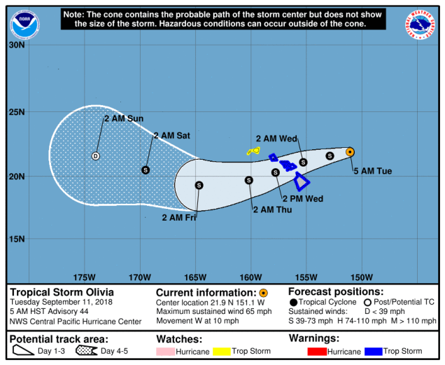
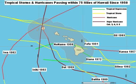
In the Eastern Pacific Tropical Depression Paul is nearly 1000 miles southwest of Mexico, and expected to dissipate over open water in the next 24-36 hours, so we really don’t need to spend any more time on that storm. To the west, Tropical Storm Olivia is bearing down on the Hawaiian Islands. As of early Tuesday afternoon, Olivia was centered about 380 miles east of Honolulu, moving toward the west at 10 mph. Maximum sustained winds were near 65 mph, and slow by steady weakening is expected over the next few days. Tropical Storm Warnings are in effect for most of Hawaii, except Kauai where a Tropical Storm Watch is in effect. Olivia is expected to cross the Hawaiian islands on Wednesday. Unlike Hurricane Lane a few weeks ago which produced heavy rain across the Big Island, but stayed offshore, Olivia will likely bring heavy rain and gusty winds to much of the island chain. In some of the mountain areas, especially on the Big Island, rainfall totals of 10-20 inches and locally heavy may result in flooding in some areas once again.

image011
Most tropical systems that impact Hawaii don’t come in from the east, especially not ones moving across the central part of the island chain. Image provided by the Central Pacific Hurricane Center.

In the Western Pacific, Tropical Storm Barijat is expected to move across the South China Sea over the next few days while remaining fairly weak. As of midday Tuesday, Barijat was centered about 215 miles southeast of Hong Kong with maximum sustained winds near 40 mph, moving towards the west at 12 mph. It should continue on a general westward track for the next day or so with some strengthening possible, before crossing China’s Leizhou Peninsula late Wednesday. After that, it is expected to weaken before making a final landfall as a weak tropical storm or a tropical depression in northern Vietnam on Thursday or Friday. Heavy rain is the main threat with this system.

rbtop_lalo-animated
Tropical Storm Barijat remains weak southeast of Hong Kong, but does have a nice cluster of strong thunderstorms near the center. Loop provided by NOAA.

The bigger story in the Western Pacific is Super Typhoon Mangkhut. At midday Tuesday, Mangkhut, located roughly halfway between the Northern Mariana Islands and northern Philippines, had maximum sustained winds near 160 mph. It is moving westward at 14 mph, but a turn more toward the west-northwest is expected over the next day or two. Mangkhut has likely not peaked in intensity yet, and could strengthen a bit more over the next 24-36 hours. Yesterday, it crosses the Northern Mariana Islands, producing wind gusts of up to 90 mph and dropping over 10 inches of rain on Guam.

wp2618
Mangkhut is a Super Typhoon, and should remain one for another 2-3 days. After that, how strong it is will be determined by how close it comes to northern Luzon. Image provided by the Joint Typhoon Warning Center.

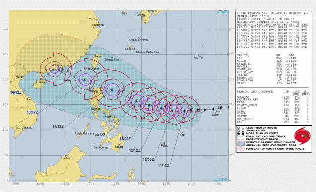
The current forecast calls for Mangkhut to pass just north of the Philippines later this week, likely close enough to bring heavy rain and strong winds to Luzon. A deviation slightly to the south of the expected track could result in landfall, and significant impacts to northern Luzon. Beyond that, a track into the South China Sea and some slow weakening is expected. The storm will become an increasing threat to southern China, including Hong Kong, by this weekend.

Multiple Tropical Systems Threaten Land

It seems like just a week or two ago we were saying how quiet that the Atlantic had been. Now, Mr. Dolby is right, it’s hyperactive – and so is the Pacific.

Right now, all of the media hype is centered on Tropical Storm Florence. As of 5pm EDT Saturday, Florence was centered about 800 miles southeast of Bermuda, moving toward the west at 5 mph. After reaching Category 4 strength a few days ago, Florence has weakened to a tropical storm with maximum sustained winds near 70 mph. Over the next day or two, Florence will be moving into an area where conditions will be favorable for development, plus there is plenty of warm water ahead, so the system will likely become a hurricane again. Rapid strengthening is possible over the next few days, and Florence could become a Major Hurricane (Category 3 or stronger) again over the next few days.

tcheat_atlantic_2018090112
There is plenty of warm water in the western Atlantic to help fuel a strong hurricane. Image provided by Weathermodels.com

The future track of Florence still has plenty of questions that can’t be answered yet, but have significant implications. A ridge of high pressure will build in to the north of Florence, sending it on a general westward track, towards the southeastern United States for the next couple of days. The questions are – How strong is that ridge to the north of Florence? How will it be oriented? If it’s strong enough, it will continue to drive the system west or west-northwestward, sending it into the Carolinas, Georgia, or possibly even northern Florida. If the high is weaker, or centered a little more to the east, it could allow the system to turn more northward as it gets close to the coastline, which could allow it to recurve out to sea without making landfall, or it could stall close to the coastline. This will obviously determine what impacts Florence may or may not have on the Southeast (as well as the Mid-Atlantic and possibly even the Northeast) later in the week. People with interests along the East Coast, especially the Mid-Atlantic states and the Southeast, should keep a close eye on the future of Florence. Rough surf ahead of Florence will impact most of the East Coast beginning on Sunday, and continuing through the week.

While Florence is gathering all of the attention (and the hype), it is far from the only system that is a threat to land right now. Newly-formed Tropical Storm Isaac was centered about 1640 miles east of the Windward Islands as of 5pm EDT Saturday, moving toward the west at 7 mph. Isaac had maximum sustained winds near 40 mph, and is expected to steadily strengthen over the next few days while crossing the Atlantic. The current forecast calls for Isaac to become a hurricane by early in the week. As we get toward midweek, if it continues on its current westward track, it could become an increasing threat to the Lesser Antilles. Many parts of this area are still recovering from getting battered by Irma and Maria last summer, and were hoping for a quiet hurricane season. This is not the news that anybody in that region wants to hear.

al092018
A hurricane heading for the Caribbean? No, that’s not what anybody wants to hear, not after last season. Image provided by the University of Wisconsin.

To the east, Tropical Storm Helene is a threat to the Cabo Verde Islands tonight and Sunday. Tropical Storm Warnings and Hurricane Watches are in effect for the islands of Santiago, Fogo, and Brava. As of 8pm EDT Saturday, Helene was centered about 125 miles southeast of Praia in the Cabo Verde Islands, moving towards the west at 13 mph. Maximum sustained winds are near 60 mph, and additional strengthening is expected. Helene could become a hurricane on Sunday. It will bring gusty winds and heavy rainfall to parts of the Cabo Verde Islands for the next 24-36 hours. Rainfall totals of 4-8 inches could result in flooding and mudslides across the islands. Once it pulls away from the islands later on Sunday, it should continue off toward the west-northwest while strengthening a bit more. By mid-week, a turn more towards the northwest is expected, with a weakening trend ensuing as Helene moves over colder waters.

233955_5day_cone_no_line_and_wind
Forecast track for Tropical Storm Helene. Image provided by the National Hurricane Center.

Think all the action is in the Atlantic? Think again – the Pacific remains active as well. Hurricane Olivia was centered about 1000 miles east of Hilo, Hawaii Saturday evening, moving towards the west at 15 mph. We know that we were more focused on Norman earlier in the week, but Norman is out of the picture, and Olivia is now the bigger threat. Olivia has maximum sustained winds near 85 mph right now. The forecast for Olivia is for a general west to west-southwest motion over the next few days, with a gradual weakening trend expected. By mid-week, Olivia should have weakened to a tropical storm as it approaches and then moves across the Hawaiian Islands. Rough surf is expected across Hawaii over the next few days, with gusty winds likely as the system approaches later on Tuesday and into Wednesday. The main threat with this system will be heavy rain, leading to flooding across the area. Hurricane Lane brought torrential rainfall and flooding to the area a few weeks ago, and this will likely renew flooding in some of the same areas that have not cleaned up yet. We’re not expecting 20-40 or more inches of rain like Lane produced, but 8 to 15 inches and locally heavier is possible, especially in the normally favored upslope locations.

17E_tracks_latest
Just what Hawaii needs – more rain! Model forecasts for the track of Hurricane Olivia. Image provided by Tropical Tidbits.

Back to the east a bit, Tropical Depression 18-E has formed off the west coast of Mexico. As of Saturday evening, the system was centered about 665 miles southwest of Cabo San Lucas, Mexico, moving toward the west-northwest at 12 mph. Maximum sustained winds are near 35 mph, and strengthening is expected. The system should become a tropical storm on Sunday. The storm should head northwestward for the next 24-36 hours, before turning back towards the west-northwest. It should remain over open water, with no threat to any land areas. At this time, the system is not expected to become a hurricane before it starts to weaken over colder waters towards midweek.

EP182018_5day_cone_no_line
Forecast track for Tropical Depression 18-E. Finally, a fish storm that is no threat to land. Image provided by the National Hurricane Center.

We’re not done yet! Heading much farther to the west, Tropical Storm Mangkhut (not King Tut) continues to strengthen in the Western Pacific Ocean. As of Saturday evening, Mangkhut was centered a little more than 800 miles east of Guam, moving toward the west at 23 mph. It has maximum sustained winds near 65 mph, and is expected to steadily strengthen while heading westward over the next few days. It should become a typhoon on Sunday. The system is expected to move across the Northern Mariana Islands on Monday as a strengthening typhoon. Strong winds, torrential rainfall and storm surge are all threats to the islands, including the large US military presence on Guam. Considering that it’s a small island in the middle of the vast Pacific Ocean, Guam actually gets hit by typhoons quite a bit. Mangkhut should continue on a general west or west-northwest course beyond that, possibly becoming a Super Typhoon (equivalent to a Category 4 or 5 Hurricane in the Atlantic/Eastern Pacific) by midweek. Its too early to determine where it goes beyond that, but it could become a threat to the northern Philippines, Taiwan, or southeastern China late in the week.

wp2618 (1)
Forecast track for Tropical Storm Mangkhut. Image provided by the Joint Typhoon Warning Center.

Believe it or not, that’s not all. It looks like another tropical system could be developing closer to the northern Philippines. We’ll worry about that one once it actually forms. we’ve got our hands full already.

By the way, we didn’t even get to what’s left of Tropical Storm Gordon. Yeah, we’re focusing on active tropical systems in this post, but Gordon is going to bring heavy rain to the Ohio Valley into Sunday, and parts of the Mid-Atlantic and Northeast later Sunday into Monday. Several inches of rain are possible in parts of this area, with flooding expected. We’ve lost count of how many times this has happened in the Mid-Atlantic states this year. Somehow, we have a hunch that this isn’t the last time it’ll happen this year either.

Gordon Flashes Toward the Gulf Coast

The peak of hurricane season in the Atlantic occurs around September 10 on average. As we rapidly approach that date, the Atlantic is heating up. We’ve got two named storms right now, and possibly another on the way. Things aren’t quiet in the Pacific either.

GOES16-TAW-GEOCOLOR-900x540 (1)
The Atlantic is getting active again. We’ve got Gordon in the Gulf, and Florence for the fishes. Loop provided by NOAA.

The biggest threat right now is Tropical Storm Gordon. As of midday Tuesday, Gordon was centered about 130 miles south-southeast of Mobile, Alabama, moving towards the northwest at 15 mph. Maximum sustained winds were near 65 mph, and some additional strengthening is possible. Gordon doesn’t look like a classic tropical system just yet, but there are signs that it is getting its act together, and it could become a hurricane before making landfall along the Mississippi or Alabama coastline tonight. Hurricane and Tropical Storm Warnings are in effect for much of the north-central Gulf Coast, with a Storm Surge Warning also in effect for parts of the area.

GFS 50-STATES USA Alabama & Miss Total Precipitation 72
There’s a lot of rain heading for the Gulf Coast and the Deep South over the next few days. Image provided by Weathermodels.com

While storm surge flooding and strong winds are threats with Gordon, heavy rain will be a more prolonged threat to the region. Once it makes landfall it will slow down, which is not good news at all. This will keep the heavy rain threat going for a few days. Rainfall totals of 3-6 inches, with localized totals to 10 inches or more, could result in flooding across much of the region. By Friday, as the system continues to drift northward, an approaching cold front will pick it up, and send it off towards the Ohio Valley and Great Lakes.

Meanwhile, in the Central Atlantic Ocean, Florence has become the third hurricane of the season. As of midday Tuesday, Florence was about halfway between the Lesser Antilles and Cape Verde Islands, moving toward the west-northwest at 12 mph. Florence has maximum sustained winds near 75 mph, but the current forecast calls for Florence to weaken a bit over the next few days before regaining a little strength. Florence should continue in a general northwestward track through the week, remaining over open water. After that, things may get a little complicated.

atcf_AL06_current
Florence will head towards the northwest for the next few days. After that? That’s a really good question. Image provided by WeatherBell.

The steering currents in the central Atlantic Ocean are forecast to weaken later this week, making the future track of Florence a lot more uncertain once we get into the weekend. Right now, the more likely scenario is the usual one – an approaching trough of low pressure picks up Florence and it curves northward and eventually harmlessly out to sea. However, if that trough is not strong enough to grab Florence, it could meander around for a while or start to drift westward as a ridge of high pressure builds back in to the north. While Florence would still likely head out to sea eventually, this scenario would imply a potential threat to the East Coast later next week. We won’t know which scenario is more likely until we get to this weekend at the earliest. There are a few models, as well as members of some of the Ensembles that do show that threat. As we mentioned in our Weekly Outlook, we think that the odds of an East Coast impact are fairly low at this point (despite the internet hype), but they are certainly not zero, so we’ll keep an eye on it.

But wait, there’s more! A developing low pressure system is passing south of the Cape Verde Islands today. It is expected to continue on a general west to west-northwest track over open waters for the next several days. Conditions are favorable for development, and the system could become a tropical depression later this week. It is still a week away from impacting any land areas, if it were to even get that far.

92L_tracks_latest
We may have yet another Atlantic system to deal with later this week. Image provided by Tropical Tidbits.

In the Pacific, Hurricane Olivia will strengthen a bit more over the next day or two as it continues to move away from Mexico and into the open waters of the Eastern Pacific, so we won’t spend much time on it. Hurricane Norman, however, is the system getting attention in that part of the world.

EP162018_5day_cone_with_line
Hawaii isn’t going to get hit again (at least not yet). Norman should turn well before getting near the Islands. Image provided by the Central Pacific Hurricane Center.

As of Tuesday morning, Norman was centered about 750 miles east of Hilo, Hawaii, moving toward the west at 17 mph. Maximum sustained winds were near 85 mph. Norman is expected to maintain its current strength for another day or two before a weakening trend begins. The system is expected to turn more toward the northwest later this week, passing safely east and north of Hawaii towards the end of the week. It will send some rough surf towards the islands, but that should be the only impact as the region continues to recover from Hurricane Lane.

What about the Western Pacific? Anyone care? Anyone? Bueller? Typhoon Jebi made landfall on Japan’s main island of Honshu early this morning. It’s weakened to a tropical storm, and has moved into the Sea of Japan. It should weaken and dissipate as it moves into far eastern Russia over the next day or so.

Triple Tropical Trouble in the Pacific

We’re heading towards the peak of hurricane season in the Atlantic, but it’s the Pacific where the problems are right now. In fact, we’ve got not one, not two, but three storms that may impact land later this week.

Hurricane Lane has been steadily moving across the Eastern and Central Pacific Ocean for the past week while strengthening. As of midday Monday. Lane was centered about 615 miles southeast of Hilo, Hawaii, moving towards the west at 14 mph.  Lane’s maximum sustained winds peaked at 140 mph on Saturday, and have since dropped to 125 mph, meaning it is still a Category 3 Hurricane. It is expected to maintain its current intensity through Tuesday before a more pronounced weakening trend develops.

14E_tracks_latest (1)
Hurricane Lane is a threat to Hawaii later this week. Will it be a direct hit or another miss? Too early to tell. Image provided by Tropical Tidbits.

The forecast track for Lane is a bit problematic. Lane is expected to continue westward for another day or two before turning more towards the northwest or north. Where it makes that turn is very important, as it will determine what, if any, impact Lane may have on Hawaii. At the very least, we’re looking some rough surf, rainfall, and gusty winds for parts of the island chain. However, a closer pass brings stronger winds and heavy rain in, especially to some of the northwestern islands.

image011
Map showing all tropical storms and hurricanes that have passed with 75 miles of the Hawaiian Islands. Image provided by the Central Pacific Hurricane Center.

As we mentioned in our Weekly Outlook, Hawaii doesn’t get direct hits from hurricanes very often. In fact, since their tropical cyclone records began in 1950, only 3 hurricanes have made direct hits on Hawaii – Hurricane Dot in 1959, Hurricane Iwa in 1982, and Hurricane Iniki in 1992 – all of which hit the island of Kauai . Dot and Iwa were both Category 1 storms when they hit, while Iniki was a Category 4 storm. There have been a lot more tropical storms that have hit the islands, and hurricanes that passed close enough to impact part of the island chain, but only those 3 have had direct impacts.

rbtop_lalo-animated
Typhoon Soulik has a rather large eye at the moment. Loop provided by NOAA.

Heading much farther to the west, Typhoon Soulik is threatening parts of Japan and South Korea. As of midday Monday, Soulik was centered about 415 miles east of Okinawa, moving toward the west-northwest at 12 mph. Soulik has maximum sustained winds near 115 mph, and is expected to maintain that intensity for the next 24-36 hours. After that it should start to weaken a bit while turning more toward the northwest as it crosses the Ryukyu islands southwest of Japan. After that, a turn more towards the north and steady weakening are expected as Soulik heads for the coast of South Korea. If the storm makes the northerly turn a little later than currently anticipated, it could remain over the Yellow Sea a little longer, and make landfall in North Korea instead, likely in a somewhat weaker state. Either way, strong winds, heavy rainfall, and flooding are likely across the Korean Peninsula towards midweek.

wp2218
Typhoon Soulik is expected to hit Korea later this week. Image provided by the Joint Typhoon Warning Center.

A little southeast of Soulik is Typhoon Cimaron, which is pulling away from the Northern Mariana Islands. Cimaron is a minimal typhoon with maximum sustained winds near 75 mph, but steady strengthening is expected over the next 24-36 hours. Cimaron is expected to take a northwest track, passing close to Iwo Jima before turning more towards the north by midweek. After that it will likely head towards Japan, with landfall expected later this week as a minimal typhoon, likely around the same time that Soulik is impacting Korea. Cimaron will bring strong winds, and heavy rain to an area that was already recovering from deadly flooding earlier this summer.

1820-00
Forecast track for Typhoon Cimaron. Image provided by the Japanese Meteorological Agency.

While the Pacific remains somewhat active, the Atlantic is still quiet. While the forecast models show this continuing for the remainder of August, climatology says that the trend won’t continue into September, as the peak of hurricane season is mid-September climatologically. The pattern remains unfavorable for storms to form now, but it remains to be seen if that pattern will continue into September.

Bob
Yesterday was the 27th anniversary of Hurricane Bob’s landfall in Southern New England. Image provided by the National Weather Service office in Norton, MA.

While talking about the Atlantic and climatology, we’d be remiss if we didn’t mention that yesterday was the 27th anniversary of Hurricane Bob slamming into Southern New England. If 27 years seems like a long time, you’d be correct. Using data back to 1851, a tropical storm makes landfall in Southern New England or Long Island once every 4 years, while a hurricane makes landfall once every 8 years. The last tropical storm to make landfall was Irene, which passed right over New York City in 2011, so we’re about due for another one. As for hurricanes, while we’ve been threatened several times in the past few years, that 27-year gap since Bob is the 2nd longest on record, second only to the 28 year gap between 1896 and 1924. In other words, we are very overdue. There are a lot of people that live around here that have never experienced a hurricane. We saw storms wreak havoc and create lots of damage around here last winter. If a full-fledged hurricane were to make landfall, especially one that’s a Category 2 or 3, we’d be in real trouble. Only 3 Major Hurricanes (Category 3 or higher) have made landfall in New England, and the last was Carol in 1954. The other 2 were a storm in September of 1869, and another one you have heard about before that hit the area in September of 1938. If one of those comes along again, the damage Sandy brought to this area would probably look minor in comparison.

Weekly Outlook: July 9-15, 2018

We’ve got a little bit of everything in this week’s forecast. We’ll have some heat, some days with low humidity, some days with high humidity, sunshine, showers, and thunderstorms, an offshore hurricane. Wait, what?

snow-coming-soon-to-a-street-near-you1
OK, maybe we don’t have a little bit of EVERYTHING in the forecast.

Despite all the different things involved, we actually have a fairly straightforward forecast again this week. We start off with high pressure in control. While this morning won’t be as cooler as the last couple were, it will still be refreshing, as we’ll start the day in the 50s for much of the region. With plenty of sunshine expected, combined with low humidity, temperatures will quickly jump into the 80s this afternoon, with some lower 90s expected as well.

Tuesday will be a different story. Humidity levels will increase, but not to the levels we had last week. It will be hot though, with temperatures well into the 80s and lower 90s again. We’ll also have a cold front moving in from the northwest. This front may trigger some showers and thunderstorms during the afternoon and evening. We’re not expecting much in the way of severe weather with these storms, in fact, we’re not expecting the storms to be that widespread.

nam3km_mslp_pcpn_frzn_neus_fh36-60
Thunderstorm development is not expected to be widespread across the region late Tuesday into Tuesday night. Loop provided by Tropical Tidbits.

Behind the front, high pressure returns for Thursday and Friday with sunshine, low humidity, and seasonably warm temperatures. That high pressure settles offshore over the weekend, which in turn brings southwesterly winds to the region. Southwest winds will bring hot and humid air back in, but we’ll also have the chance for showers and thunderstorms both days.

download (1)
Satellite loop of Tropical Storm Chris spinning off the coast of North Carolina late Sunday night and early Monday morning. Loop provided by NOAA.

OK, back to that offshore hurricane that we mentioned. It’s actually not a hurricane yet (as of when this post was written), but it should become one on Monday. Tropical Storm Chris has been meandering around off the coast of North Carolina for the past day or two, slowly gathering strength. As that cold front approaches from the northwest on Tuesday, it should provide the nudge that Chris needs to start moving northeastward. It will pass well south and east of New England towards the middle of the week. While it will generate some rough surf along the coast, and large waves offshore, unless you are planning to take your boat (or someone else’s) out, then the impacts here will be negligible.

9-km ECMWF USA Cities New England Precip Type & MSLP 102
The ECMWF model brings Chris closest to New England, but it keeps the rainfall offshore, with gusty winds confined to Cape Cod and Southeastern Massachusetts, Image provided by Weathermodels.com

While we’re discussing the tropics, we’ll also mention former Hurricane Beryl. Beryl was a tiny system from the start, and quickly dissipated as it moved across the Lesser Antilles Sunday night. It will bring some gusty winds and heavy rain to parts of Puerto Rico and the Virgin Islands today. Just when they need as many parts of the area are still trying to recover from the double whammy of Irma and Maria last year, right? So why are we mentioning it? Well, a few of the models are showing the potential for what’s left of Beryl to regenerate after it crosses Hispaniola and moves into the Bahamas towards the middle of the week. After that, some of them have it move up the coast as a very weak system. While the odds of this happening seem low right now, they’re not zero. We’re not expecting it to regenerate, but we’re also not completely ruling it out yet either.

Monday: Sunshine, sunshine, and more sunshine. High 86-93, cooler along the South Coast.

Monday night: Clear skies, just a few high clouds at times. Low 60-67.

Tuesday: Sunshine to start, then clouds move in with a few late-day showers or thunderstorms possible. High 88-95, cooler along the South Coast.

Tuesday night: Partly to mostly cloudy with showers and thunderstorms possible, mainly during the evening. Low 62-69.

Wednesday: A mix of sunshine and clouds, less humid. High 77-84, cooler along the coast.

Thursday: Sunshine and some high clouds. It may be a bit breezy along the coast. High 80-87, cooler along the coast.

Friday: Partly to mostly sunny. High 82-89, cooler along the South Coast.

Saturday: A mix of sun and clouds, slight chance for a shower or thunderstorm. High 83-90.

Sunday:  Partly sunny, some showers and thunderstorms are possible. High 84-91.

Hurricane Season Starts Early Once Again

Officially, hurricane season in the Atlantic Basin starts on June 1 and ends on November 30. In recent years, Mother Nature has not adhered to that calendar, and she won’t this year either.

download
GOES-16 satellite loop of newly-developed Subtropical Storm Alberto in the northwestern Caribbean. Loop provided by NOAA.

A cluster of thunderstorms that has been slowly organizing over the Yucatan Peninsula and northwestern Caribbean Sea for the past several days has been designated as Subtropical Storm Alberto by the National Hurricane Center this morning. As of 11am EDT, Alberto had maximum sustained winds of 40 mph, and was centered about 55 miles south of Cozumel, Mexico, moving toward the north-northeast at 6mph. Tropical Storm Watches have been issued for portions of western Cuba as well as Mexico’s Yucatan Peninsula.

90L_tracks_latest (1)
Latest model forecasts for the track of Alberto. Image provided by Tropical Tidbits.

Most of the forecast models are in good agreement that the system should continue northward toward the central Gulf Coast, with some strengthening expected. Westerly wind shear will keep Alberto fairly weak through Saturday, but as the shear relaxes and Alberto moves over the warm waters of the Gulf, more strengthening is expected. While Alberto is not currently expected to reach hurricane strength, if conditions are favorable for rapid strengthening before landfall, it is possible.

GFS 50-STATES USA Southeast US Total Precipitation 114
GFS model forecast for rainfall through Tuesday across the Southeast. Image provided by Weathermodels.com

While gusty winds and storm surge are threats near where the system makes landfall, by far, the bigger threats are heavy rain and flooding. The shield of heavy rain will extend far from the center, bringing heavy rain to much of the Southeast and the Gulf Coast during the Memorial Day Weekend. Widespread totals of 2-4 inches are expected, with localized totals in excess of 10 inches possible in some areas. Flood watches have already been issued for parts of the region, and more are expected to be issued in the coming days. Once inland, Alberto may slow down, which could keep the heavy rain going well into next week across portions of the Tennessee and Ohio Valleys.

may_21_31
Location where all tropical cyclones have formed in the Atlantic and Eastern Pacific during the last 10 days of May. Image provided by the National Hurricane Center.

Last year, what turned out to be a very active season got off to a very early start when Tropical Storm Arlene formed in the central Atlantic on April 19. The 2016 season got an even earlier start when Hurricane Alex formed on January 14 and Tropical Storm Bonnie developed on May 27. In 2015, Tropical Storm Ana formed on May 8, and made landfall near Myrtle Beach, South Carolina on May 10, the earliest landfalling storm on record in the United States. The peak of the season usually occurs from mid-August through late September, but an early start isn’t unusual. Based on data from 1966-2009, the first named storm in the Atlantic doesn’t normally develop until July 9 and the first hurricane doesn’t develop until August 10.

2018 Hurricane names - FINAL as of 052118 - 700x430
Name List for the 2018 Atlantic Hurricane Season. Image provided by NOAA.

An early start is not always a harbinger of what the season will bring. NOAA issued their seasonal hurricane outlook on Thursday, and it calls for a 35 percent chance for an above normal season, a 40 percent chance for a normal season, and a 25 percent chance for a below normal season. Many in the media are reporting that as a “75 percent chance for a normal or above normal season.” That’s because disasters = ratings. If you’re not a fan of disasters, you could interpret this as a 65 percent chance for a normal or below normal season. (See what we did there?) An average season consists of 12 named storms, of which 6 become hurricanes and 3 become major hurricanes. The 2017 season consisted of 17 named storms, of which 10 became hurricanes and 6 were major hurricanes. These storms produced an estimated $280 billion in damage, making 2017 the costliest season on record. Many parts of the Caribbean, as well as Texas and Florida are still struggling to recover from direct hits by Hurricanes HarveyIrma, and Maria.

tracks-at-2017
2017 was a hyper-active season in the Atlantic, but also a devastating one, with several storms, many powerful, making landfall. Image provided by the National Hurricane Center.

While last year was both very active and featured a lot of landfalling storms, an active season doesn’t guarantee that a storm will make landfall in the United States though. In 2010, there were 19 named storms, 12 hurricanes, and 5 major hurricanes. Only 1 storm, Tropical Storm Bonnie, made landfall in the United States. On the flip side, 1992 was a quiet season, with just 7 named storms, 4 hurricanes, and 1 major hurricane, with the first named storm not forming until August 16. Of course, that first storm was Andrew, which slammed into South Florida on August 24 as a Category 5 hurricane, one of just 3 Category 5 storms to ever make landfall in the United States.

Here in New England, we should always pay attention when a storm is nearing the Bahamas, as those are the ones that have the potential to impact us. Using data back to 1851, a tropical storm makes landfall in Southern New England or Long Island once every 4 years, while a hurricane makes landfall once every 8 years. The last tropical storm to make landfall was Irene, which passed right over New York City in 2011, so we’re about due for another one. As for hurricanes, while we’ve been threatened several times in the past few years, the last one to make landfall was Hurricane Bob in 1991. That 27-year gap is the 2nd longest on record, second only to the 28 year gap between 1896 and 1924. In other words, we are very overdue.

2e4f74f77e03202235ecff2f6ed87773
Satellite photo of Hurricane Bob approaching New England. Bob was the last hurricane to make landfall in New England – 27 years ago. Image provided by NOAA.

While Alberto has formed and is moving into the Gulf of Mexico, it will not be a threat to New England. Even if something were to form off the East Coast in the next few weeks and head this way, the waters off of New England are too cold to sustain a tropical system, so we’d see something more like a typical nor’easter. Only two tropical storms have ever made landfall in the Northeast before the end of June. The first was an unnamed minimal tropical storm that crossed Long Island and went into southern Connecticut on May 30, 1908. The other was Tropical Storm Agnes, which made landfall near New York City on June 22, 1972, then caused devastating flooding across parts of the Mid-Atlantic states. In terms of hurricanes, the earliest one to ever make landfall up this way was Hurricane Belle, which slammed into Long Island with 90 mph winds on August 9, 1976. We did have Hurricane Arthur pass just offshore of Nantucket on July 4 in 2014. While it did not make landfall, it made for a rather wet and cool holiday, especially across Cape Cod and southeastern Massachusetts. Statistically, the most likely time for a hurricane to hit New England is between the middle of August and late September. Of the 23 hurricanes that made landfall in New England or Long Island since 1851, 20 of them have done so between August 19 and September 27.

Some of the statistics in this post were supplied by Gary Gray and David Vallee. David is probably the local expert in Southern New England on tropical systems and their impacts on the region. He’s written several papers on them including a nice review of 20th Century storms.

Weekly Outlook: September 18-24, 2017

Ready for another quiet week weather-wise? You must be in San Diego then, because this week certainly won’t be quiet around here.

The week starts off with high pressure over Atlantic Canada. The southeast to south flow around this high pressure area will keep plenty of moisture in place, resulting in some dense fog to start the day in parts of the region. The fog will burn off, but clouds will dominate the day with only a few sunny breaks as some of the moisture from Jose streams northward into the region. That brings us to Jose, and what it will do.

12L_tracks_latest (1)
Model forecasts for the track of Hurricane Jose. Could it make another loop, this time south of New England? Time will tell. Image provided by Tropical Tidbits.


A Tropical Storm Watch is in effect for the East Coast from Fenwick Island, Delaware, northward to Plymouth, Massachusetts. Although Jose remains a hurricane now, it will weaken to a tropical storm as it heads northward in between Bermuda and the East Coast. Although there are still a few forecast models that bring the center of the storm very close to, if not right across, the south coast of New England, the more likely scenario is for the storm to make a right turn, and pass south and east of the area. It will still be close enough to spread in some locally heavy rain, with gusty winds along the coast as well. As we talked about in our blog post on Saturday, this is basically a “nor’easter with a name.” The rain will move into the region on Tuesday, with the heaviest rain and strongest winds likely Tuesday night into Wednesday, mainly across southeastern Massachusetts and Cape Cod. There will still be some locally heavier showers farther inland, and winds may occasionally be gusty, with the biggest impact from the storm will basically be south and east of I-95. Along the coast, we may also have to deal with some coastal flooding, as the persistent east to northeast winds will create some big waves, plus tides are running high this week thanks to a New Moon on Wednesday. Despite all of this, this storm is not going to be anything remotely resembling Harvey or Irma. We have said this a few times already, but we’ll say it again, just because it has a name, does not make it that big of a deal. We get storms that hit us harder nearly every fall and winter.

gfs_tprecip_boston_21
GFS model forecast for rainfall through Friday evening. Most areas north and west of Boston would receive an inch or less, with the heaviest amounts confined to Cape Cod if this forecast verifies. Image provided by WeatherBell.


Thursday and Friday are where things start to get to tricky around here. The trend in the models for the past few runs has been for the storm to slow down and slowly turn back toward the south once it gets past us. Given that the storm will be even weaker by then as it sits over the colder waters off of the coast, winds won’t be much of an issue, except across the Cape and Islands. However, if the storm does slow down or even stall, it will keep the clouds locked in for Thursday and Friday, as well as the threat for more rain, mainly across the Cape and southeastern Massachusetts. Of course, if the storm slows down or makes the turn a little farther away than currently expected, then we may see some improving conditions. No matter what happens Thursday and Friday, by next weekend, the storm pulls far enough away to allow high pressure to build back in with sunshine returning to the entire region.

sfct.us_ne
Next Sunday could be quite a warm late-September afternoon if you believe the GFS. We’re not forecasting temperatures quite this warm, but it is certainly possible. Image provided by Pivotal Weather.


Monday: Some patchy dense fog early, otherwise plenty of clouds with a few sunny breaks. A shower or two can’t be ruled out. High 69-76.

Monday night: Cloudy and becoming breezy with rain developing along the South Coast after midnight, gradually spreading northward. Low 59-66.

Tuesday: Windy along the coast, breezy elsewhere with periods of rain and showers, possibly heavy at times along the South Coast and across the Cape. High 64-71.

Tuesday night: Windy, especially along the coast, with periods of rain, heavy at times, especially south of Boston. Low 60-67.

Wednesday: Windy along the coast, breezy elsewhere with periods of rain and showers, heavy at times along the South Coast and across the Cape. High 65-72.

Thursday: Mostly cloudy, still breezy across the Cape. Chance for more rain and showers, mainly across Cape Cod and southeastern Massachusetts. High 63-70 along the coast and south of Boston, 70-77 elsewhere.

Friday: Plenty of clouds with some sunny breaks, especially north and west of Boston. Some additional showers are still possible across Cape Cod. High 61-68 along the coast and south of Boston, 68-75 elsewhere.

Saturday: Becoming partly to mostly sunny, though clouds may be slow to move out across Cape Cod. High 74-81, cooler along the coast and across Cape Cod.

Sunday: Plenty of sunshine. High 78-85.

rb_lalo-animated
Hurricane Maria continues to strengthen while approaching the Leeward Islands. Loop provided by NOAA.


Finally, we’ll talk about Hurricane Maria. Maria will move across the Leeward Islands today, a little south of where Irma went across. As of early Monday morning, Maria had maximum sustained winds of 90 mph, and more strengthening is expected. Maria could become a Category 3 hurricane before crossing the islands. Once it crosses the Leeward Islands, it will turn a bit more toward the northwest. On this track, it will likely pass very close to St. Croix, and near or across Puerto Rico., possibly as a Category 3 or 4 Hurricane While St. Croix fared better than most of the other Virgin Islands during Irma, this is a region that does not need another major storm moving through. Once it gets past Puerto Rico and the Virgin Islands, there is a chance it could threaten the East Coast.  Any potential impacts would be at least a week away at this point, so it’s not worth worrying about for now. However, we figured it was at least worth mentioning that after Jose passes by, not to let your guard down. We’ll keep tabs on Maria’s progress, and if the threat does materialize, we’ll let you know.

gefs_cyclone_atlantic_41
Track forecasts for Maria from the various members of the GFS Ensemble. Image provided by WeatherBell.

A “Nor’easter With a Name” Heads Our Way, While Maria Threatens the Caribbean

We’ve got a nor’easter with a name heading our way, but the bigger story will be unfolding in the Caribbean over the next few days, as yet another hurricane takes aim on the islands.

rb-animated
From left to right: Hurricane Jose, Tropical Storm Maria, and Tropical Storm Lee. Loop provided by NOAA.

With Irma dissipating over land a few days ago, Jose was the only active tropical system in the Atlantic for a few days, and thus grabbed most of the attention while it did a little loop a few hundred miles east of the Bahamas. It weakened to a tropical storm, but has since become a hurricane again. As of 5pm Saturday, it was centered a little less than 500 miles south-southeast of Cape Hatteras, NC with maximum sustained winds near 80 mph. It was moving towards the north at about 6 mph. The forecast for Jose for the next 48 hours is fairly easy. It will continue to head northward around the edge of a large high pressure area. While it remains over very warm water, there is still plenty of wind shear aloft, and the wind shear will counteract the warm water, preventing much, if any, additional intensification. It will produce rough seas for much of the western Atlantic, and also create a high risk of rip currents from New England to the Carolinas.

ww3_height_dir_nwatl_25 (1)
Jose will will produce rough seas and rip currents across much of the East Coast over the next few days. Image provided by WeatherBell.

By Tuesday, Jose will start to move over colder waters as it passes north of the Gulf Stream, so it should start to weaken. At the same time, it will start to encounter westerly winds aloft, which will turn it more towards the northeast and eventually east. On this track, the center should pass about 100 to 150 miles south and east of Cape Cod as a weakening tropical storm. By this point, the storm may not even be completely tropical any more, and starting the transition into an extratropical system. It will pass close enough to bring gusty winds and some rainfall into southeastern portions of New England, but the impacts will be similar to a fall nor’easter, with temperatures in the 60s not the 40s (or colder). The biggest impacts will be across Cape Cod, where some wind gusts in excess of 60 mph are possible. Coastal flooding will also be an issue, as tides are running high this week with the New Moon on Wednesday. Rainfall totals of 1-3 inches and locally heavier shouldn’t cause any flooding issues, and will actually be beneficial, as some parts of the region have been dry lately, with some drought conditions starting to reappear. In other words, don’t freak out, we’ll probably have worse storms to deal with later this fall or winter, especially since many of those will have the dreaded s-word involved.

12L_tracks_latest
Model forecast for the track of Hurricane Jose. Landfall is not expected Image provided by TropicalTidbits.

Well out in the Atlantic is Tropical Storm Lee. As of 5pm Saturday, Lee was centered about 720 miles west-southwest of the Cape Verde Islands, moving towards the west at 10 mph. Lee has maximum sustained winds near 40 mph. Lee is expected to continue on a general west to west-northwest track for the next few days. While some modest strengthening is possible over the next day or two, the long-term outlook is for Lee to weaken by early next week, and probably dissipate over the open waters of the central Atlantic, well away from any land areas.

203915_5day_cone_no_line_and_wind
Forecast track for Tropical Storm Lee. Yawn. Image provided by the National Hurricane Center.

While Jose has been grabbing the headlines, and Lee remains weak, Tropical Storm Maria has formed east of the Lesser Antilles, and this storm will likely grab most of the attention over the next few days, especially after Jose starts to move away from the East Coast.

Tropical Storm Maria formed Saturday afternoon east of the Lesser Antilles. As of 5pm Saturday, it was centered about 620 miles east-southeast of the Lesser Antilles, moving towards the west at 20 mph. Maximum sustained winds are near 50 mph, and additional strengthening is expected. Maria could become a hurricane on Sunday. A hurricane watch has already been issued for the islands of Antigua, Barbuda, St. Kitts, Nevis, and Montserrat, with a tropical storm watch in effect for the islands of St. Lucia, Martinique, Guadeloupe, Dominica, Barbados, St. Vincent, and the Grenadines. Additional watches and warnings are likely to be issued tonight and Sunday.

al152017
Model forecasts for the track of Tropical Storm Maria. This is going to be a problem for some of the islands. Image provided by the University of Wisconsin-Madison.

Maria is expected to cross the Lesser Antilles as a hurricane on Monday. It should pass farther south than Irma, which will spare the islands that were devastated from another direct hit. Once it gets past the Antilles, it will turn more towards the northwest, and head towards the Virgin Islands and Puerto Rico for Tuesday into Wednesday. It could become a strong hurricane by this point, so residents on this region, still trying to cleanup after Irma, need to play close attention to Maria. While Irma delivered a heavy blow to much of the British and US Virgin Islands, it did not do as much damage on St. Croix, the southernmost and largest island of the chain. If Maria does in fact track farther south than Irma did, then St. Croix could conceivably get hit harder than the rest of the Virgin Islands. This will be something to pay attention to in the next few days.

12_es1
GFS Ensemble forecast for the track of Tropical Storm Maria. Image provided by the University at Albany.


What about Maria’s future beyond mid-week? Well, at this point, almost anything is possible. As you can see from the GFS Ensemble plot above, it could continue northwestward towards Florida, turn more toward the north and potentially be a threat to the East Coast, or turn more towards the northeast and head out to sea. We won’t have a better idea about that until the middle of the upcoming week, if not later. To quote a friend of the blog when asked about Maria’s future:

“It’s way, way, way too early to even conjecture on that. Let’s just say, given the pattern, that folks on the East Coast shouldn’t just hit the snooze button once Jose departs.”

That’s probably the best advice we could give you right now as well.

Here We Go Again – Watching the Tropics

Mid-September is the peak of hurricane season in the Atlantic, and although things seemed a bit more quiet after Irma finally dissipated, that’s about to change again. We’ve got two active tropical systems in the Atlantic right now, and possibly a third one on the way. Bond villain Elliot Carver’s line from “Tomorrow Never Dies” seemed appropriate tonight.

14L_tracks_latest
Tropical Depression 14 will wreak havoc on the fish in the Central Atlantic for the next several days, but not much else. Image provided by Tropical Tidbits.


We’ll start by talking about newly-formed Tropical Depression 14. (We’re saving the best for last – we’ve got to keep you reading somehow). It developed late Thursday evening about 380 miles south-southwest of the Cape Verde Islands. It’s got maximum sustained winds near 35 mph, and is scooting along towards the west-northwest at 22 mph. The system is expected to strengthen into a tropical storm over the next day or so, and could even become a hurricane this weekend. A general west-northwest to northwest track is expected for the next 3-5 days, before it turns more toward the north-northwest. Meteorologists like to refer to a storm like this as a “fish storm”, because aside from the fish, it won’t really impact anyone else.

AL96_current
A disturbance in the Atlantic could become a tropical depression by early next week, and could threaten the Lesser Antilles. Or maybe it won’t. We’ll wait and see. Image provided by WeatherBell.


Another disturbance is located in the Central Atlantic, about 1200 miles east-southeast of the Lesser Antilles early this morning. (Don’t worry, we’re getting to the good part). Right now, it’s just a poorly organized cluster of thunderstorms, but conditions are favorable for it to become more organized over the next few days. It could become a tropical depression or a tropical storm by early next week. Right now, it looks like it could take a track towards the Lesser Antilles, but this is far from a given at the moment. Let’s wait to see if it even forms first, then we’ll worry about where it’s going.

Finally, we get to Tropical Storm Jose. You may remember earlier this week, when Jose was a Category 4 storm, and looked like it was going to hammer some of the same islands that Irma wiped out a week ago. Well, it turned just in time, sparing those islands for the most part. Jose then stalled out north of Puerto Rico and made an anti-cyclonic loop. Since it was sitting over the same general area of several days, it churned up the water pretty good, bringing the much cooler water down below to the top, and dispersing the warmer water that was there. This is called “upwelling.” Since tropical systems need to be over warm water to maintain their strength, when they sit for too long in the same location, they tend to weaken. Jose weakened from a storm that was on the cusp of Category 5 status with maximum sustained winds near 155 mph last Friday, to a tropical storm with 70 mph winds early this morning.

Jose is likely to start moving towards the west and eventually northwest over the next few days. This will bring the storm back over warmer waters, and also move it away from the wind shear that has been tearing it apart, which will allow it to strengthen into a hurricane again. A large ridge of high pressure is in place across the Atlantic, and that will help to steer Jose through the weekend. Jose will move around the edge of the ridge, heading towards the northwest and eventually north, likely as a hurricane, this weekend. Since it’s been sitting over the open ocean for a while and will start heading towards the west and northwest, it will send some large swells towards the Bahamas, Bermuda, and the East Coast.

ww3_height_dir_nwatl_25
Jose will generate large swells for most of the East Coast by Sunday. Image provided by WeatherBell.


Once we get past the weekend, things get complicated. As you may recall, in our Weekly Outlook on Monday, we mentioned that a few of the models showed a potential threat from Jose next week, but that the threat was very low. Well, it’s not quite so low any more. If you had asked us on Monday what the odds were of a direct impact, we’d have probably said 1 in 50, or about 2%. Now? We’ll call it 1 in 6, or about 15%. In other words, it’s still a low threat, but it’s certainly gotten our attention now. If you live near the South Coast or Cape Cod, it should probably have your attention too. So what has changed? Most of the models have shifted westward with their tracks for Jose over the past few days. As you may recall, a similar shift occurred with Irma. Many models kept trying to bring Irma up the East Coast, and even a day or two before landfall, many of them showed a track up the east side of Florida and into the Carolinas. With this westward shift, the models now bring the storm much closer to the East Coast. There are still plenty of them that keep it well offshore. Others keep it offshore, but close enough to bring some rain and strong winds into parts of southeastern New England. A few models bring the storm right across the region, likely in a much-weakened state. Then there’s a couple of models that are just completely insane. One model has Jose hit New England as a weak hurricane, move offshore, loop around, then try to come back again as a weak nor’easter a couple of days later. What it does beyond that is even more insane, which is why we’re ignoring that model completely.


The timing on when this could possibly impact our area would be around Tuesday or Wednesday of next week. Obviously, things can and will change between now and then. We’ll keep a close eye on it. We’ll obviously detail it in our Weekly Outlook Monday morning, but if the threat increases more, we may have another blog post this weekend about the storm.

For those interested, the Atlantic isn’t the only active area right now. Tropical Storm Norma could become a hurricane before heading towards Mexico’s Baja peninsula. Tropical Depression 15-E could become a tropical storm but remain over open waters in the Eastern Pacific. Typhoon Doksuri is making landfall in Vietnam, and Typhoon Talim will make landfall in southwestern Japan this weekend. Yeah, things are a little busy right now.

Weekly Outlook: September 11-17, 2017

While Irma continues to plow further into Florida and Jose spends some quality time over the open Atlantic, we’ve got a nice quiet week on our hands, thanks to a large area of high pressure. Not only will it be quiet, it’ll be warm too.

CODNEXLAB-2km-FL-rad-ani96-201709110430-100-100-raw
Radar loop showing Irma’s progress northward across Florida after landfall. Loop provided by the College of DuPage.

First, we’ll talk about the tropics. Irma continues to move northward across central Florida while weakening early this morning. Irma will weaken to a tropical storm during the day on Monday while turning more towards the northwest. The center of Irma should move across southern Georgia, and then up towards the Tennessee Valley, where it will likely dissipate towards the middle of the week. Winds will still be a major problem across Florida today, especially central and northern Florida, but the bigger threat will shift to rainfall as we head through the day and into mid-week. Additional rainfall totals of 6-12 inches or more are expected across northern Florida and southern Georgia, with 2-6 inches possible from the Tennessee Valley into parts of the Carolinas. This will likely lead to flooding in some areas. While some of this moisture will stream up here in the form of clouds, only a few showers are possible, as high pressure keeps the rain bottled up to our south.

nam_total_precip_se_29
Heavy rain will likely lead to flooding across the Southeast over the next few days thanks to Irma. Image provided by WeatherBell.

We also are keeping an eye on Hurricane Jose. Early this morning, Jose was a few hundred miles east of the southern Bahamas with top winds near 100 mph. Jose will likely weaken a bit, and stall out or move very erratically for the next few days. As we get towards midweek, Jose may start to strengthen again while turning back towards the west, before eventually turning northward. While it is possible that Jose could be a threat to the East Coast, sometime next weekend or early in the following week, that threat is fairly low at this point. Yes, a couple of the computer models have shown a rather strong Hurricane Jose heading right up the East Coast around 10-12 days from now, but those models have problems picking out where things will be 3 days from now, never mind 10 days from now. In fact, 10 days ago, some of those exact same models showed Irma making landfall in New England. They were only off by over 1000 miles. In other words, despite seeing people post scary looking maps on Facebook and Twitter and telling you to start preparing now because New England could be next, we wouldn’t worry too much about it. If there is going to be a threat, we’ll let you know well in advance.

18_es1
Despite what you may have seen on the Internet, Hurricane Jose is not a threat to any land areas over the next 5-7 days, except possibly the Bahamas. Beyond that, there is a low threat to the East Coast, but a track out to sea is still more likely. Image provided by the University at Albany.

As for our actual forecast, well, that’s pretty easy. High pressure keeps us warm and dry through at least Thursday. A weak front may try to drop down into the region with some cooler conditions and possibly a few showers late in the week. Next weekend looks cooler, but likely still dry, as high pressure tries to build back into the region.

hires_t2max_boston_49
Tuesday is looking like the pick of the week with sunshine and temperatures in the 80s. Normal highs for mid-September are in the middle 70s. Image provided by WeatherBell.

Monday: Plenty of sunshine. High 75-82.

Monday night: Clear to partly cloudy. Low 52-59.

Tuesday: Mostly sunny. High 80-87.

Tuesday night: Clear skies.  Low 55-62.

Wednesday: Sunshine and some high clouds. High 78-85.

Thursday: A mix of sun and clouds. High 78-85.

Friday: Intervals of clouds and sunshine with some showers possible. High 73-80, possibly cooler right along the coast, especially in the afternoon.

Saturday: Partly sunny, slight chance for a shower. High 69-76.

Sunday: Partly to mostly sunny. High 73-80.

sn10_acc.us_nw
Temperatures will top 90 in parts of Montana today. By the end of the week, it could be snowing there. Yup, it’s getting to be that time of year. Image provided by Pivotal Weather.