Officially, hurricane season in the Atlantic Basin starts on June 1 and ends on November 30. In recent years, Mother Nature has not adhered to that calendar, and she won’t this year either.

A cluster of thunderstorms that has been slowly organizing over the Yucatan Peninsula and northwestern Caribbean Sea for the past several days has been designated as Subtropical Storm Alberto by the National Hurricane Center this morning. As of 11am EDT, Alberto had maximum sustained winds of 40 mph, and was centered about 55 miles south of Cozumel, Mexico, moving toward the north-northeast at 6mph. Tropical Storm Watches have been issued for portions of western Cuba as well as Mexico’s Yucatan Peninsula.

Most of the forecast models are in good agreement that the system should continue northward toward the central Gulf Coast, with some strengthening expected. Westerly wind shear will keep Alberto fairly weak through Saturday, but as the shear relaxes and Alberto moves over the warm waters of the Gulf, more strengthening is expected. While Alberto is not currently expected to reach hurricane strength, if conditions are favorable for rapid strengthening before landfall, it is possible.

While gusty winds and storm surge are threats near where the system makes landfall, by far, the bigger threats are heavy rain and flooding. The shield of heavy rain will extend far from the center, bringing heavy rain to much of the Southeast and the Gulf Coast during the Memorial Day Weekend. Widespread totals of 2-4 inches are expected, with localized totals in excess of 10 inches possible in some areas. Flood watches have already been issued for parts of the region, and more are expected to be issued in the coming days. Once inland, Alberto may slow down, which could keep the heavy rain going well into next week across portions of the Tennessee and Ohio Valleys.

Last year, what turned out to be a very active season got off to a very early start when Tropical Storm Arlene formed in the central Atlantic on April 19. The 2016 season got an even earlier start when Hurricane Alex formed on January 14 and Tropical Storm Bonnie developed on May 27. In 2015, Tropical Storm Ana formed on May 8, and made landfall near Myrtle Beach, South Carolina on May 10, the earliest landfalling storm on record in the United States. The peak of the season usually occurs from mid-August through late September, but an early start isn’t unusual. Based on data from 1966-2009, the first named storm in the Atlantic doesn’t normally develop until July 9 and the first hurricane doesn’t develop until August 10.

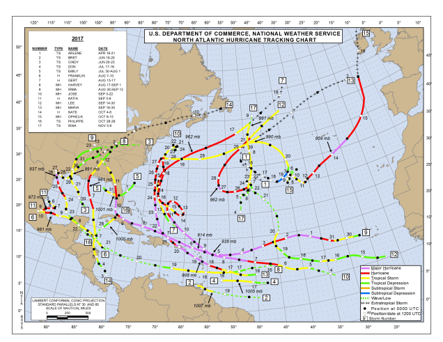
An early start is not always a harbinger of what the season will bring. NOAA issued their seasonal hurricane outlook on Thursday, and it calls for a 35 percent chance for an above normal season, a 40 percent chance for a normal season, and a 25 percent chance for a below normal season. Many in the media are reporting that as a “75 percent chance for a normal or above normal season.” That’s because disasters = ratings. If you’re not a fan of disasters, you could interpret this as a 65 percent chance for a normal or below normal season. (See what we did there?) An average season consists of 12 named storms, of which 6 become hurricanes and 3 become major hurricanes. The 2017 season consisted of 17 named storms, of which 10 became hurricanes and 6 were major hurricanes. These storms produced an estimated $280 billion in damage, making 2017 the costliest season on record. Many parts of the Caribbean, as well as Texas and Florida are still struggling to recover from direct hits by Hurricanes Harvey, Irma, and Maria.
While last year was both very active and featured a lot of landfalling storms, an active season doesn’t guarantee that a storm will make landfall in the United States though. In 2010, there were 19 named storms, 12 hurricanes, and 5 major hurricanes. Only 1 storm, Tropical Storm Bonnie, made landfall in the United States. On the flip side, 1992 was a quiet season, with just 7 named storms, 4 hurricanes, and 1 major hurricane, with the first named storm not forming until August 16. Of course, that first storm was Andrew, which slammed into South Florida on August 24 as a Category 5 hurricane, one of just 3 Category 5 storms to ever make landfall in the United States.
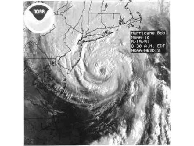
Here in New England, we should always pay attention when a storm is nearing the Bahamas, as those are the ones that have the potential to impact us. Using data back to 1851, a tropical storm makes landfall in Southern New England or Long Island once every 4 years, while a hurricane makes landfall once every 8 years. The last tropical storm to make landfall was Irene, which passed right over New York City in 2011, so we’re about due for another one. As for hurricanes, while we’ve been threatened several times in the past few years, the last one to make landfall was Hurricane Bob in 1991. That 27-year gap is the 2nd longest on record, second only to the 28 year gap between 1896 and 1924. In other words, we are very overdue.
While Alberto has formed and is moving into the Gulf of Mexico, it will not be a threat to New England. Even if something were to form off the East Coast in the next few weeks and head this way, the waters off of New England are too cold to sustain a tropical system, so we’d see something more like a typical nor’easter. Only two tropical storms have ever made landfall in the Northeast before the end of June. The first was an unnamed minimal tropical storm that crossed Long Island and went into southern Connecticut on May 30, 1908. The other was Tropical Storm Agnes, which made landfall near New York City on June 22, 1972, then caused devastating flooding across parts of the Mid-Atlantic states. In terms of hurricanes, the earliest one to ever make landfall up this way was Hurricane Belle, which slammed into Long Island with 90 mph winds on August 9, 1976. We did have Hurricane Arthur pass just offshore of Nantucket on July 4 in 2014. While it did not make landfall, it made for a rather wet and cool holiday, especially across Cape Cod and southeastern Massachusetts. Statistically, the most likely time for a hurricane to hit New England is between the middle of August and late September. Of the 23 hurricanes that made landfall in New England or Long Island since 1851, 20 of them have done so between August 19 and September 27.
Some of the statistics in this post were supplied by Gary Gray and David Vallee. David is probably the local expert in Southern New England on tropical systems and their impacts on the region. He’s written several papers on them including a nice review of 20th Century storms.
