We’re into September, which means that meteorological fall has started. Time for cooler weather, leaves changing colors, pumpkin-flavored everything, and football. So naturally, we’re starting the week off with hot and humid conditions.
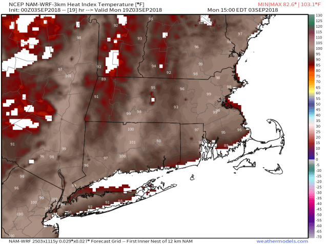
A ridge of high pressure remains in place off the East Coast, so the hot and humid weather that we’ve dealt with for much of the summer has returned. Heat Advisories are in effect for much of the region, as temperatures should get well into the 80s and lower 90s both today and Tuesday. However, with dewpoints in the upper 60s and 70s, the heat index will be in the middle to upper 90s, hence the heat advisories.
Later on Tuesday, a backdoor cold front will drop southward, bringing some cooler air into eastern parts of the area for Tuesday night and Wednesday. “Cooler” is a relative term. In April or May, a backdoor front results in easterly or northeasterly winds off of water that is only in the 40s and 50s, so coastal areas get quite chill while it stays relatively mild well inland. In this case, we’ll have northeast or east winds blowing off of water that is in the lower 70s, so it’s not going to cool off that much at the coast.
The front lifts back northward Wednesday night, resulting in another hot and humid day on Thursday. However, a cold front will be approaching from the northwest. This front may kick off some showers and thunderstorms late in the day and into Thursday night and early Friday. This is where things get more questionable. That front will likely stall out near the South Coast. Exactly where it stalls out is not clear though. If it stalls right along the South Coast, then Friday and Saturday could be cool and damp with periods of showers at times. If it stalls much farther offshore, then the clouds may hang around, especially from Boston southward, but the showers would likely stay offshore. For now, we’re leaning towards the drier scenario. Sunday is an even bigger question mark. One model has high pressure build in with partial sunshine and temperatures only in the 60s, while another model has low pressure move into the Great Lakes, likely the remains of what is currently Potential Tropical Cyclone Seven (more on that in a moment), with cool conditions, but also some rain in the afternoon. Since that’s the Patriots home opener, we’ll be keeping an eye on that forecast as the week goes on.

Labor Day: Some patchy fog early, otherwise partly to mostly sunny. High 86-93, a little cooler along the South Coast.
Monday night: Clear to partly cloudy. Low 68-75.
Tuesday: A mix of sun and clouds, chance for a few showers. High 85-92, turning cooler along the east coast in the afternoon.
Tuesday night: Partly to mostly cloudy. Low 64-71.
Wednesday: Early clouds, then becoming partly to mostly sunny. High 81-88, coolest along the coast.
Thursday: Sunshine fades behind increasing clouds, showers and thunderstorms are possible late in the day and at night. High 87-94.
Friday: Mostly cloudy, a few more showers are possible. High 72-79.
Saturday: Intervals of clouds and sunshine. High 68-75.
Sunday: More clouds than sun, chance for showers in the afternoon. High 65-72.

Now that we’re into September, we’re approaching the peak on tropical season in the Atlantic, and we have 2 systems to keep an eye on. The more immediate threat is a system that at the time this blog was written was still labelled Potential Tropical Cyclone Seven”. It is expected to become a tropical depression at some point on Monday as it crosses the Florida Keys. It will then turn northwestward while strengthening over the Gulf of Mexico. The current track calls for landfall in southeastern Louisiana Tuesday night as a tropical storm. Storm surge flooding and gusty winds will be threats with this system, but the main threat is heavy rain that could lead to flooding across much of the Gulf Coast.
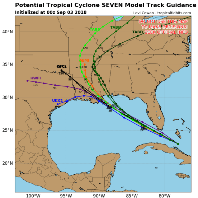
Well out into the Atlantic we have Tropical Storm Florence. Florence is expected to remain fairly weak as it crosses the Atlantic over the next several days, with only some minor fluctuations in intensity. You may have read on the internet over the weekend that Florence is a threat to the East Coast. Yes, a couple of the models do show that potential, but many others don’t. At this point, it’s more hype than anything else. If it were to become a threat, that would still be a good 10 days or so from now. We’re not worried about it right now. We’d put the odds of an East Coast threat fairly low right now, but not zero, not yet. If it were to become a threat, we’d let you know well in advance.

One thought on “Weekly Outlook: September 3-9, 2018”