It’s Here – The First Accumulating Snow of the Season

You can’t put it off any longer. We warned you on Monday that it was coming. The inevitable has arrived. Our first measurable snowfall of the season is knocking on the door. For those of you that hate snow – we apologize in advance.

gfs.prateptype_cat.us_ne.2017120812-loop
GFS model forecast for the progression of our system on Saturday. Image provided by Pivotal Weather.

It’s our first storm of the winter, and it shouldn’t be a big deal. The good news is, it’s going to happen over the weekend, which will minimize problems on the road. The number of people around here that can’t drive properly to begin with is already fairly high, and when you add precipitation into the mix, that number increases. Add in wintry precipitation, and the number increases even more. So, to have most of the snow fall during a Saturday evening/night will keep the number of people on the roads to a minimum.

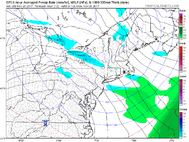
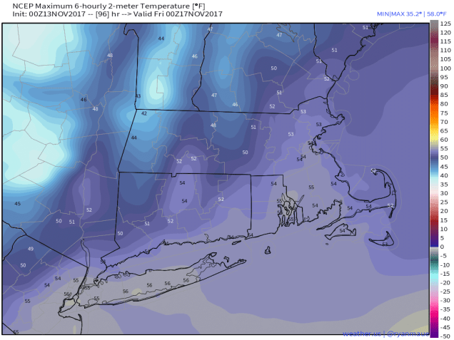
The front that moved through here a few days ago, bringing an end to our mild weather, stalled out offshore. A wave of low pressure will ride along it this weekend, strengthening as it moves over the Atlantic south and east of the region. This is fairly typical, and how we get a lot of our snow events in the winter. It should spread precipitation into the South Coast by daybreak Saturday, spreading northward across our area during Saturday morning and early afternoon. Snow will quickly change to rain across Cape Cod, with a change to rain also expected right along the eastern coast and across parts of southeastern Massachusetts. Water temperatures are still well into the 40s, so any wind blowing off the water will bring milder air into coastal areas. Winds won’t be that strong, and they’ll be more northerly than northeasterly, which will likely prevent the warmer air from penetrating too far inland. As winds shift into the northwest behind the storm early Sunday morning, this will likely change the rain back to snow, even at the coast and across much of the Cape.

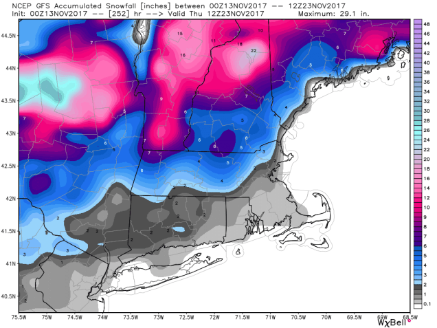
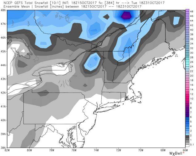
So, how much are we looking at? The map below is a close approximation, but we’ll break down a bit farther:

Cape Cod: Little to no accumulation.
Coastal SE Mass/Cape Ann: 1″ or so, maybe 2″
Interior SE Mass/Providence/Boston/North Shore/Seacoast: 2-4″
Much of the rest of Eastern Mass/Southern NH/Northern RI: 3-6″

We do think a few places could see 7 or even 8″ of accumulation, with the best chance of that happening from the hills in NW Rhode Island into Worcester County and possibly parts of the Merrimack Valley.

gfs_snow_Ku_acc_boston_9
Snowfall forecast from the GFS model. This closely matches our thinking for how much snow is expected. Image provided by WeatherBell.


Even though the snow will start by midday, it might not stick to pavements right away. Ground temperatures are getting colder, but pavements are a bit warmer, and having cars on the roads will keep the temperatures up a bit due to the friction. Once some steadier snow moves in, that won’t matter as much. So, if you’re heading out Saturday afternoon or evening, especially north and west of Boston, be careful. Hopefully, road crews will be ready for this, since it is the first storm of the season.

Once this system goes by, we’ll turn our attention to the next one on Tuesday. There’s still plenty of disagreements among the models on that one, so we’ll get into more detail in our Monday morning Outlook.

Weekly Outlook: December 4-10, 2017

Snow. There, we said it. We know that a lot of you hate that word. However, this is New England, it’s inevitable in the winter. The last time that most of us saw any snow around here was on April Fool’s Day. You’ve had 8+ months without it. Guess what? We’ve got some #FlakeNews for you. There’s snow in the forecast this week.

t69kh
No, it’s not going to be this bad……this time. However, winter is just getting started. You’ve been warned.


The week will actually start off with high pressure in control. That means dry and seasonably cool conditions for Monday. By Tuesday, the high will slide off to the east and a strong storm system will move across the Great Lakes. Ahead of it, we’ll have gusty southwest winds ushering some mild air into the region. Tuesday will likely see highs in the 50s across much of the area. With the mild air comes some rain though, mainly late Tuesday into early Wednesday. Some of the rain Tuesday night could be locally heavy. A cold front moves through Wednesday morning, with the rain ending by midday. Whatever the temperature is when you wake up on Wednesday is likely the warmest it will be all day. Behind the front, temperatures will drop during the afternoon. Thursday is the transition day. High pressure tries to build in, but a weak upper-level disturbance will pass to the north. For the most part, the day will be dry, with temperatures close to where they should be in early December.

gfs_t2m_massachusetts_54
GFS Temperature forecast for 1am Wednesday. It’s going to be unseasonably mild Tuesday night, with temperatures likely staying in the 50s all night long, despite the rain. Image provided by Weather.us

This brings us to Friday and the weekend. We’re going to have back-to-back storms to contend with, one Friday into early Saturday, and one Saturday night into Sunday. Right now, neither storm looks like it will be a big deal, but there are plenty of questions that need to be answered as well. First and foremost – what track will these storms take? There’s lots of disagreement between the models at this point. Some models keep the Friday system too far offshore to have much of an impact on us. Some bring it closer and give us a decent amount of precipitation Friday night. The same things can be said about the potential Sunday system as well. These are things that we can’t answer yet, as there are too many things that have to happen first before we have a better idea. One thing we can tell you is that with either system, we are likely looking at precipitation falling in the form of snow across the interior. Closer to the coast, some snow is possible, but more likely, the bulk of the precipitation would fall as rain. With water temperatures still in the 40s, any wind off the water will allow temperatures to moderate quickly, making rain more likely. As for how much snow might fall – again, that is highly dependent on the storm track. A track well offshore with either storm could mean virtually no precipitation at all, thus no snowfall. A track closer to the coast could mean that you need to find your shovels and make sure the snowblower is gassed up and the plow is back on the pickup. We don’t expect significant snowfall around here no matter what the track is, but we’ll keep you informed later in the week, when we have a better idea as to what might happen. Behind that, even colder air will settle into the region next week. Yup, winter is coming alright.

gefs_t2ma_5d_conus_55
Temperature will be well below normal across the eastern half of the nation for much of next week. Image provided by WeatherBell.


Monday: Plenty of sunshine. High 41-48.

Monday night: Becoming mostly cloudy. Low 31-38.

Tuesday: Cloudy and becoming breezy with showers developing in the afternoon. High 48-55.

Tuesday night: Windy and mild with periods of rain. Temperatures hold steady or rise a bit overnight.

Wednesday: Showers ending in the morning, some clearing possible in the afternoon. High 52-59 at daybreak, dropping into the 40s in the afternoon.

Thursday: A mix of sunshine and clouds. High 38-45.

Friday: Mostly cloudy, chance for snow developing late in the day, changing to rain across Cape Cod and along the immediate coast. High 34-41.

Saturday: Any rain or snow ends early, then becoming partly sunny. High 33-40.

Sunday: Mostly cloudy with a chance for rain or snow, especially along the coast. High 33-40.

Weekly Outlook: November 27 – December 3, 2017

Believe it or not, December starts later this week. Yup, 2017 is nearly over already. As we get to the end of November, another quite week lies ahead.

hrrr_snow_neng_17
Some snow showers will move across Northern new England today, mainly this morning. We could see a few stray flakes around here, but if there are any, it’ll be mainly before most of you read this. Image provided by WeatherBell.

The week starts off with high pressure in control. Sure, Monday will be windy and a little cool, but we’ll have sunshine, and besides, it’s late November, it’s supposed to be cool outside! Tuesday will be feature a little more sunshine, and a little less wind, with high pressure still in control. A cold front will approach the region on Wednesday, with some clouds, and maybe a shower in the morning. Sunshine will return in the afternoon, and it will actually turn milder, with highs getting into the 50s. we’ll cool off again for Thursday, but the dry and cool weather will be short-lived. Another cold front will approach on Friday, bringing with it a better chance for some rain. High pressure returns for the weekend, with improving conditions on Saturday, followed by partial sunshine and cool temperatures on Sunday.

ecmwf_t2max_massachusetts_72
Wednesday is looking like it will be a mild day. Image provided by Weather.us

Monday: Some morning clouds, then becoming partly to mostly sunny and breezy. High 40-47.

Monday night: Clear skies with diminishing winds. Low 19-26.

Tuesday: Sunshine and just a few clouds. High 39-46.

Tuesday night: Becoming partly to mostly cloudy and breezy. Low 36-43 in the evening, then temperatures hold steady or rise a bit overnight.

Wednesday: Intervals of clouds and sunshine, breezy, slight chance for a stray shower, mainly early. High 50-57.

Thursday: Plenty of sunshine to start, clouds start to filter back in during the afternoon. High 41-48.

Friday: Cloudy and breezy with rain likely. High 47-54.

Saturday: Perhaps a few lingering showers along the coast early, otherwise becoming partly to mostly sunny and breezy. High 43-50.

Sunday: A mix of sunshine and clouds. High 41-48.

Finally, here at Storm HQ, we focus on short-range forecasts, 7 days or less. However, some of you are wondering what the winter has in store for us. Our colleagues over at Woods Hill Weather issued their Winter Outlook Sunday afternoon. If you’re curious about their thought on the winter, we would advise you to give it a read. For short-range forecasts, we usually end up with very similar thinking, so we trust what they have to say, and you should too.

Weekly Outlook: November 20-26, 2017

Thanksgiving week has arrived, which means that we’re already getting to the tail end of 2017. Before you know it, we’ll be talking about snowstorms. No, we’re not talking about them yet, but soon, we will be. This is New England after all.

gfs_t2m_massachusetts_108
It’s going to be chilly for the Black Friday early morning sales. Make sure you’re wearing a winter coat and gloves if you’re going to fight the crowds. (Or you could just sleep in and wait for Cyber Monday.) Image provided by Weather.us

For the most part, we’re looking at a fairly benign pattern this week. We start off with high pressure in control for Monday and Tuesday, with sunshine and cool temperatures. On Wednesday, a cold front will approach from the west while a coastal storm passes offshore. The result will be some rain showers, especially along the coastline. High pressure builds back in on Thanksgiving with sunshine returning, making for some great weather for high school football and traveling to see family. High pressure remains in control on Friday, keeping the dry and cool weather in place, so dress properly if you’re heading out for the “Doorbuster” sales on Black Friday. By Saturday, a strong low pressure system will pass well to our north and west, across southeastern Canada. This will result in a bit of warmup, but also some rain showers. The system drags a strong cold front across the region Saturday night, with breezy and colder conditions expected on Sunday. A few rain or snow showers are possible with that frontal passage on Sunday.

gfs_mslp_pcpn_frzn_neus_fh12-168
The GFS model shows that the next 7 days will be fairly quiet, with only a little precipitation on Wednesday and again late Saturday, Loop provided by Tropical Tidbits..

Monday: A mix of sunshine and clouds, slight chance for a morning snow flurry, breezy. High 36-43.

Monday night: Clear to partly cloudy. Low 28-35.

Tuesday: Sunshine and some high clouds at times, still breezy. High 50-57.

Tuesday night: Becoming partly to mostly cloudy with winds diminishing overnight. Low 43-50 in the evening, then temperatures hold steady or rise a bit overnight.

Wednesday: Mostly cloudy with scattered showers, especially along the coast. High 48-55 early, then temperatures drop in the afternoon.

Thanksgiving: Partly to mostly sunny. High 37-44.

Friday: Sunshine dominates again. High 41-48.

Saturday: Becoming mostly cloudy and breezy with some showers possible. High 47-54.

Sunday: Chance for a rain or snow shower early, then becoming partly to mostly sunny and breezy. High 38-45.

Weekly Outlook: November 13-19, 2017

Well, now that it is actually feeling like November outside, we’ve got a more sobering thought for you. Christmas is six weeks from today. Six weeks. You know what that means, right? Yup, we’ll be talking about that dreaded “s-word” soon. It doesn’t look like we’ll worry about it for most of this week, but rest assured, it’s coming.

As for this week, the week will start off with, to quote a friend of the blog, “not exactly a chamber of commerce day.” A weak system passes offshore today, close enough to spread some showers in, mainly from Boston southward, during the afternoon. We suppose there could be a few wet flakes mixed in, but generally, just some light rain is expected. High pressure builds in after that with dry and cool conditions for Tuesday and Wednesday. Temperatures will start to moderate on Thursday ahead of a storm system. However, with the milder conditions will come some more rainfall. The rain ends during the afternoon as a cold front moves through. This sets up another dry and but cold day on Friday.

gfs_t2max_massachusetts_96
No more highs in the 70s, but temperatures on Thursday should be in the 50s, which is near to a little above normal for mid-November. Image provided by Weather.US

Next weekend is where things get interesting. Another storm system will move into the Great Lakes and eventually into southeastern Canada. This will give us some precipitation Saturday into early Sunday. The precipitation may not be entirely plain rain. Remember, we’re going to have a very cold airmass in place on Friday. Warmer air will certainly move in aloft, but as it typically the case in the fall/winter, it may struggle to move in at the surface, especially inland. So, what does that mean? For the coastal plain, we’re looking at just rain. For places farther inland, especially north and west of 495, it wouldn’t be a surprise to see the precipitation start as some wet snow, before a changeover to rain, possibly with a period of sleet or freezing rain in between. This is all assuming that the precipitation moves in during the morning. If it holds off until afternoon, then the chance for wintry precipitation diminishes considerably. All in all, this doesn’t look like a big deal, but since it could be the first potential wintry event of the season, we certainly need to keep our eyes on it. The other big question is the temperatures. How warm will we get on Saturday? Across inland areas, depending on which model you believe, we could stay in the upper 30s to middle 40s, or we could soar well into the 50s. Right now, based on what we’ve seen in the past, we’re going to lean towards the cooler scenario inland, but obviously that could change. No matter what happens, a cold front pushes through early Sunday, with clearing and colder conditions expected once again.

gfs_ptype_slp_boston_23
At least one model shows the potential for a wintry mix across inland areas Saturday morning. Image provided by WeatherBell.

Monday: Cloudy with scattered showers developing, mainly along the coast and south of Boston. High 38-45, except 46-53 across southeastern Mass and Cape Cod.

Monday night: Showers taper off, but some drizzle and/or a few flurries may persist. Low 32-39.

Tuesday: Intervals of clouds and sunshine. High 39-46.

Tuesday night: Becoming mostly clear. Low 27-34.

Wednesday: Sunshine, dimmed by some high clouds during the afternoon. High 43-50.

Thursday: Showers likely in the morning, clearing  and becoming breezy late in the day. High 49-56.

Friday: Mostly sunny. Clouds start to filter in during the afternoon. High 40-47.

Saturday: Rain likely, possibly starting as a wintry mix well inland. Becoming breezy, especially across Cape Cod.  High 41-48 north and west of I-495, 49-56 south and east.

Sunday: Becoming partly to mostly sunny. High 39-46.

Of course, next week is Thanksgiving, and everyone wants to know what the weather will be live for the drive to see family. At least one model (the GFS) has a storm come through on Wednesday, with some snow, especially north and west of Boston. Other models have drier conditions. We’ll go into that forecast in more detail in next week’s outlook.

gfs_6hr_snow_acc_boston_43
If you believe the GFS model, we could be in for some snow the day before Thanksgiving. Wouldn’t that make for a lovely travel day? Image provided by WeatherBell.


Weekly Outlook: November 6-12, 2017

You’ve got one more day to enjoy the unseasonably warm weather, then changes are certainly on the way. By the end of the week, some bigger changes are coming.

The week starts off on a mild note, as most of the ones this fall have, but we’ll have plenty of clouds in place as a cold front comes marching in from the west. This front produced severe weather across much of the Midwest yesterday, and while we’re not expecting severe weather here, we are expecting some locally heavy showers from late morning into the evening, and a rumble of thunder can’t be ruled out. The showers end in the evening as a strong cold front crosses the region. That front will stall out south of New England for mid-week, and a couple of waves of low pressure will ride along it. They should be too far to the south to spread much, if any precipitation into the region, but they should keep the clouds in place. At the same time, high pressure will build into Northern New England, with more seasonable temperatures expected. This will keep us dry and cool into the middle portion of the week.

nam_total_precip_boston_13
Some places could see half an inch of rain in a short time frame today. Image provided by WeatherBell.

By Thursday, we start to prepare for the next set of changes. A strong cold front will cross the region Thursday night, producing a few showers across the region. There’s even a chance that some of those showers could have some snowflakes mixed in. (Remember – it is early November) Behind that front, colder air will come pouring into the region on Friday on gusty northwest winds. A few more snow showers are possible as well. Winds start to die down on Saturday, but despite the sunshine, temperatures will be well below normal. In fact much of the region may not even reach 40 degrees for a high. The next system heads towards the area on Sunday, with clouds streaming in followed by showers late in the day. Temperatures will start to moderate, so we’ll be looking at mainly rain showers.

gfs_t2max_massachusetts_144
Saturday is looking like it might be quite the chilly day. Image provided by weather.us

Monday: Cloudy and mild with showers developing, possibly even a thunderstorm. High 62-69.

Monday night: Becoming clear to partly cloudy. Low 35-42.

Tuesday: More clouds than sunshine. High 46-53.

Tuesday night: Partly to mostly cloudy. Low 34-41.

Wednesday: Becoming partly to mostly sunny. High 45-52.

Thursday: A mix of sun and clouds, chance for a rain or snow shower at night. High 48-55.

Friday: Partly sunny and windy. High 41-48 early, temperatures may drop in the afternoon.

Saturday: Mostly sunny. Clouds start to stream back in late in the day and at night. High 37-44.

Sunday: Becoming clouds with showers developing late in the day. High 42-49.

Weekly Outlook: October 30-November 5, 2017

If were able to sleep early this morning, then you missed quite a wild night weather-wise. Don’t worry, a repeat isn’t on the horizon.

The storm system that brought heavy rain and strong winds to the region overnight will head up into southeastern Canada today, but we’ll still feel it’s impact. Depending on how early you read this, it may still be raining, but that should end during the morning hours. While we won’t have winds gusting to hurricane force this afternoon like we did this morning, westerly winds behind the storm will still be fairly strong. Skies should clear out late today as high pressure starts to build in. This will bring us sunshine for Tuesday, but it will still remain breezy. Wednesday will start sunny, but clouds start to move in during the afternoon. After that, we jump on the roller coaster.

gfs_t2max_boston_20
One more warm day on Friday? Looking that way. Since we’re getting into November these will be harder to come by, so enjoy them while they are here. Image provided by WeatherBell.

A warm front will cross the region on Thursday, bringing some showers with it.  The warm front will extend southeastward from a storm moving across the Great Lakes. This will result in a warm day on Friday as the storm passes to our north. However, it will drag a cold front across the region, which may produce a few more showers. High pressure starts to build in from the north on Saturday, bringing some cooler weather to the area. Clouds quickly return on Saturday as a weak system moves out of the Ohio Valley towards the area. This will bring more showers in for Saturday night and Sunday. Unlike the last storm, it will be much cooler this time around. In fact, many places may struggle to reach 50 for highs on Sunday (Saturday too, for that matter). Add in the clouds and rain, and it may feel like a miserable day to be outside for any reason. Believe it or not, we could even see some wet snowflakes mix in as the rain moves in early Sunday morning, mainly across southern New Hampshire.

ecmwf_acc_snow_ne_162
That’s right – at least 1 model has some wet snow mixing in around here Sunday morning. Image provided by weather.us

Monday: Any lingering showers early this morning, then sunshine develops in the afternoon. Winds slowly diminish as well. High 60-67 early, dropping in the afternoon.

Monday night: Becoming mostly clear, still breezy. Low 40-47.

Tuesday: Sunshine and a few clouds, breezy again. High 52-59

Tuesday night: High clouds start streaming into the region with winds finally diminishing. Low 34-41.

Wednesday: Some filtered sunshine early, then clouds thicken up in the afternoon. High 50-57.

Thursday: Partly to mostly cloudy with a few showers possible. High 57-64.

Friday: More clouds than sunshine, chance for a few showers, especially late in the day. High 63-70.

Saturday: Partly to mostly sunny, clouds come back at night though. High 48-55.

Sunday: Mostly cloudy with some showers likely, possibly mixed with a little wet snow in southern New Hampshire early in the day. High 47-54.

From Drought to Flood in Under a Week?

While everyone has been enjoying the extended summer around here, one thing that hasn’t been noticed by many is the recurrence of drought conditions across the region. However, that drought may be on the way out……again.

20171017_Northeast_text
Much of New England has slipped back into Abnormally Dry or Moderate Drought conditions over the past few weeks. Image provided by the US Drought Monitor.


As you may recall, we had a fairly significant drought around here in 2016 and early in 2017. By the end of the winter, the pattern shifted, and we started getting rain…a lot of it. This wiped out the drought across the region by early summer. Everyone’s lawn was green again and once it started getting warm, everyone was happy. Then, the rains essentially stopped again. Since it was dry and warm for the latter half of summer and into fall, nobody really complained that much. Sure, lawns weren’t so green any more, and maybe the foliage wasn’t as spectacular as usual, but it was in the 70s in October for days on end! Well, the pattern is shifting once again.

pp1_today
Heavy rainfall fell across much of New England over the past 24 hours. Image provided by the Northeast River Forecast Center.


The changes already started on Tuesday. Heavy rain and thunderstorms moved slowly across the region. Rainfall totals of 1.5 to 4.5 inches were observed, with the heaviest amounts in the Connecticut Valley. Localized flooding was observed with the heavy rain, but most rivers and streams were running fairly low, so river flooding isn’t a concern at the moment. While all this rain at once isn’t always good, it will help to put a dent in the drought, and eliminate some of the rainfall deficit we’ve accumulated since the beginning of summer.

m3ppct_northeast_sep17
Except for Cape Cod, rainfall has been below to well below normal across most of New England since early July. Image provided by the Northeast Regional Climate Center.


As you may have noticed, the heavy rain of the past 24 hours has pushed offshore, but we’re not done with it yet. A cold front is slowly making its way across the region, and while temperatures will drop back to normal over the next few days, it will bring us more rain today and Thursday. As waves of low pressure ride up the front, they will bring more rainfall into the area, some of it heavy. For the rest of Wednesday, we can expect showers and drizzle, with some occasional bouts of steadier and heavier rain, especially in eastern New England. On Thursday, a stronger wave of low pressure will ride up the front, bringing another round of heavy rain into the region. Once again, the heaviest rain will be focused in eastern areas, with some downpours likely.

us_model-en-087-0_modusa_2017102506_54_519_220
Some of the rain in this map fell during the predawn hours of Wednesday. Still, some heavy rainfall totals are expected across eastern Massachusetts through Friday morning. Image provided by weather.us


The wave moves out, the front pushes offshore, and high pressure builds in for Friday and Saturday with sunshine and more seasonable temperatures. Meanwhile, another front will be approaching from the west. The storm system responsible for this front will produce the first significant snowstorm of the season from the Dakotas into the Great Lakes over the next few days. (Don’t worry, we’re not expecting any snow here.) Meanwhile, well to the south, there is a disturbance in the western Caribbean that is being monitored for development. It could become a tropical depression by this weekend before heading northward. Whether it develops or not, the system itself will likely get absorbed by the front approaching from the west, adding plenty of moisture. The result is another round of heavy rain across the region Sunday into Monday. Right now, it looks like the heaviest rainfall with this system will be focused on western New England and eastern New York, but given that it’s still 4-5 days away, we’ll keep an eye on this in case anything changes. While we’re expecting less rainfall in eastern areas, some gusty winds are likely, especially along the coastline.

qpf_048h.us_ne
The heaviest rain Sunday into Monday looks to be centered across western New England and eastern New York. Image provided by Pivotal Weather.


Between the rain with the current system, and the rain expected Sunday into Monday, some rivers may see significant rises, with some flooding possible. At the very least, we’ll see additional flash flooding like we saw on Tuesday from the heavy downpours.

Once that system moves out, drier weather moves in for Halloween. For trick-or-treaters, expect clear to partly cloudy skies with temperatures in the upper 40s to middle 50s across the area during late afternoon/early evening hours. Beyond that, it looks like we’ll have another system come through the region Wednesday night into Thursday, though this one should produce lighter rainfall.


Weekly Outlook: October 23-29, 2017

“Change. Now it’s time for change.
Nothing stays the same. Now it’s time for change.”

Motley Crue’s lyrics from 1989 are certainly an appropriate description of this week’s forecast. Changes are certainly on the way, but you’ll still have at least one more day to enjoy our extended summer.

22555692_10213989043344673_8156512546170621239_o
It was a little tough to see from the upper-level of Gillette Stadium in “Fogs-boro” Sunday night. Photo provided by Linda Galvin.

The week starts off with another warm day thanks to high pressure off the East Coast. If you watched last night’s Pats game in “Fogs-boro”, then you know that humidity levels are certainly higher now as well, thanks to a southerly flow of air. By Tuesday, the changes really start to settle in. An upper-level trough of low pressure settles into the Great Lakes, with a strong storm system at the surface as well. A frontal system extended well ahead of this storm will march towards the East Coast. With a warm, moist, southerly flow ahead of the front, we can expect some showers and gusty winds on Tuesday. Tuesday night into early Wednesday could be quite interesting as the front gets closer. Strong winds, locally heavy downpours, and even some thunderstorms are possible ahead of the front Tuesday night. Some wind gusts of 30-50 mph are possible, while rainfall totals of 1-2 inches (or more) expected for parts of the region. The front pushes offshore on Wednesday, with the showers gradually ending and cooler air settling in behind it.

qpf_acc.us_ne
Some locally heavy rainfall is possibly Tuesday into Wednesday. This may help battle drought conditions that are starting to creep back into the region. Image provided by Pivotal Weather.

The cooler air really starts to settle in on Thursday as the upper-level low moves overhead. As that happens, we can expect clouds to develop, along with some pop up showers during the afternoon. Across some of the higher elevations of Northern New England (places like Mt. Washington), some wet snow may fall with these showers. High pressure builds in for Friday and at least early Saturday. After that, things start to get complicated. Another storm system will be moving into the Great Lakes as an upper-level trough of low pressure moves into the region. At the same time, low pressure may try to take shape off the East Coast and head northward. While neither of these systems look that potent for now, they could consolidate into a fairly strong storm once they move past New England early next week. Before that, it looks like they’ll bring us some rain on Sunday, possibly as early as Saturday night. The rain may continue into next Monday, and could be heavy. Windy and much cooler conditions are possible early next week behind the system, but we’ll worry about that in next week’s outlook.

gefs_t2ma_5d_conus_51
Early indications are that October will end and November will begin with below normal temperatures – a stark contrast to much of October thus far. Image provided by WeatherBell.


Monday: Fog early, then any sunshine disappears behind thickening clouds. High 66-73.

Monday night: Cloudy and becoming breezy with some showers possible late at night. Low 57-64.

Tuesday: Windy and mild with some showers likely. High 67-74.

Tuesday night: Windy with periods of rain, possibly some thunderstorms. Low 61-68.

Wednesday: Mostly cloudy with showers and winds gradually diminishing. High 63-70.

Thursday: A mix of sun and clouds with a chance for some afternoon showers. High 57-64.

Friday: Partly to mostly sunny.  High 56-63.

Saturday: A sunny start, then clouds return. Some showers are possible at night. High 60-67.

Sunday: Mostly cloudy with more showers possible. High 58-65.

Weekly Outlook: October 16-22, 2017

Summer in October continued on Sunday, but a cold front will bring cooler conditions in today. So, are we finally into fall weather for good? To borrow a phrase from college football analyst Lee Corso – “Not so fast my friend.”

We’ll start the week off with high pressure building in, bringing cooler conditions to the region. In fact, temperatures may be below normal today. Some locations could even see some frost Tuesday morning. Don’t be alarmed, it is October, and this does frequently occur at this time of year. Tuesday looks to be on the cool side as well. After that? The warmth returns. High pressure slides offshore, and we warm right back up with dry conditions for the rest of the week and into the weekend.

us_model-en-087-0_modez_2017101512_186_519_220
Very little rainfall is expected during the next week across the most of the region. Image provided by Weather.us

It does look like the warm weather party will come to a crashing halt early next week, with a pattern change becoming more and more likely. A flip to below normal temperatures and more precipitation looks to be in the offing. In fact, some places could even see their first flakes of the season late this month. (Yeah, we just said that. Deal with it.) We’ll get into more detail on this in next week’s outlook. For now, enjoy the warm weather.

gefs_snow_mean_neng_65
Some of the longer-range Ensemble models show the potential for a little flaky white stuff away from the coastline before Halloween. Image provided by WeatherBell.

Monday: Some lingering showers across Cape Cod and SE Mass early in the day, otherwise skies will gradually clear from northwest to southeast. High 54-61.

Monday night: Becoming mostly clear and chilly with some patchy frost. Low 35-42, but some of the normally colder locations could drop close to 30.

Tuesday: Plenty of sunshine. High 51-58.

Tuesday night: Clear skies. Low 42-49.

Wednesday: Sun, sun, and more sun. High 64-71.

Thursday: Sunshine and some afternoon clouds, breezy. High 68-75.

Friday: Partly to mostly sunny. High 62-69.

Saturday: Sunshine and a few clouds. High 69-76.

Sunday:  A mix of sun and clouds. High 72-79.

qpf_acc_mm.uk
What’s left of former Hurricane Ophelia will bring heavy rain and gusty winds to parts of Ireland, northern Ireland, Scotland and northern England over the next few days. Image provided by Pivotal Weather.

Finally, we will discuss former Hurricane Ophelia. As of early Monday morning, Ophelia has transitioned into a post-tropical storm. In other words, it’s just another low pressure system now, albeit a strong one. It’s likely going to cross Ireland and the northern UK over the next day or two. Strong winds and heavy rain are expected. While some of the media are playing the hype game, the truth is, they get storms like this all the time in the fall, winter, and spring, many of which are even stronger. The difference this time is that the storm has tropical origins, so it will likely bring in more rain than your typical North Atlantic storm moving into the UK. It’s not rare, and it’s not unusual. Plenty of former tropical cyclones have become post-tropical and crossed the Atlantic, impacting the UK in the past.