Snow. There, we said it. We know that a lot of you hate that word. However, this is New England, it’s inevitable in the winter. The last time that most of us saw any snow around here was on April Fool’s Day. You’ve had 8+ months without it. Guess what? We’ve got some #FlakeNews for you. There’s snow in the forecast this week.
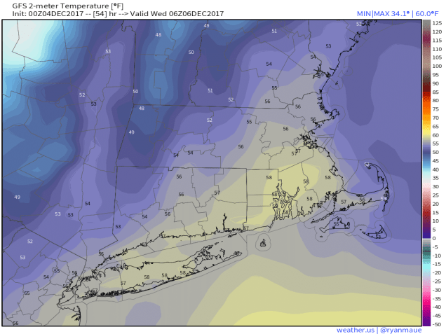
The week will actually start off with high pressure in control. That means dry and seasonably cool conditions for Monday. By Tuesday, the high will slide off to the east and a strong storm system will move across the Great Lakes. Ahead of it, we’ll have gusty southwest winds ushering some mild air into the region. Tuesday will likely see highs in the 50s across much of the area. With the mild air comes some rain though, mainly late Tuesday into early Wednesday. Some of the rain Tuesday night could be locally heavy. A cold front moves through Wednesday morning, with the rain ending by midday. Whatever the temperature is when you wake up on Wednesday is likely the warmest it will be all day. Behind the front, temperatures will drop during the afternoon. Thursday is the transition day. High pressure tries to build in, but a weak upper-level disturbance will pass to the north. For the most part, the day will be dry, with temperatures close to where they should be in early December.
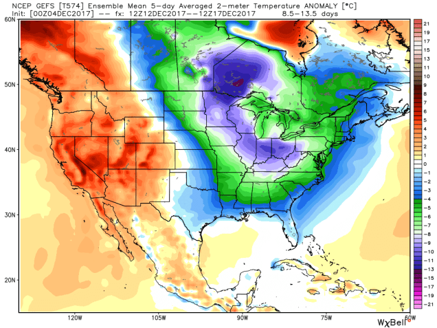
This brings us to Friday and the weekend. We’re going to have back-to-back storms to contend with, one Friday into early Saturday, and one Saturday night into Sunday. Right now, neither storm looks like it will be a big deal, but there are plenty of questions that need to be answered as well. First and foremost – what track will these storms take? There’s lots of disagreement between the models at this point. Some models keep the Friday system too far offshore to have much of an impact on us. Some bring it closer and give us a decent amount of precipitation Friday night. The same things can be said about the potential Sunday system as well. These are things that we can’t answer yet, as there are too many things that have to happen first before we have a better idea. One thing we can tell you is that with either system, we are likely looking at precipitation falling in the form of snow across the interior. Closer to the coast, some snow is possible, but more likely, the bulk of the precipitation would fall as rain. With water temperatures still in the 40s, any wind off the water will allow temperatures to moderate quickly, making rain more likely. As for how much snow might fall – again, that is highly dependent on the storm track. A track well offshore with either storm could mean virtually no precipitation at all, thus no snowfall. A track closer to the coast could mean that you need to find your shovels and make sure the snowblower is gassed up and the plow is back on the pickup. We don’t expect significant snowfall around here no matter what the track is, but we’ll keep you informed later in the week, when we have a better idea as to what might happen. Behind that, even colder air will settle into the region next week. Yup, winter is coming alright.
Monday: Plenty of sunshine. High 41-48.
Monday night: Becoming mostly cloudy. Low 31-38.
Tuesday: Cloudy and becoming breezy with showers developing in the afternoon. High 48-55.
Tuesday night: Windy and mild with periods of rain. Temperatures hold steady or rise a bit overnight.
Wednesday: Showers ending in the morning, some clearing possible in the afternoon. High 52-59 at daybreak, dropping into the 40s in the afternoon.
Thursday: A mix of sunshine and clouds. High 38-45.
Friday: Mostly cloudy, chance for snow developing late in the day, changing to rain across Cape Cod and along the immediate coast. High 34-41.
Saturday: Any rain or snow ends early, then becoming partly sunny. High 33-40.
Sunday: Mostly cloudy with a chance for rain or snow, especially along the coast. High 33-40.

One thought on “Weekly Outlook: December 4-10, 2017”