Given a choice, would you prefer cold weather or warm weather? What about a choice between rain, snow, or dry weather? Well, you’re going to get ALL of these this week!

We start the week with low pressure moving into the Great Lakes and then eventually up the St. Lawrence Valley. With low pressure passing to our north and west, we’ll be on the warm side, with rain expected, mainly in two waves. The first one will come in today, with rain developing this morning, and continuing into tonight, when it cold be locally heavy. The warm air should move in south of Boston fairly quickly, but it may take until tonight to get into the Merrimack Valley and southern New Hampshire.

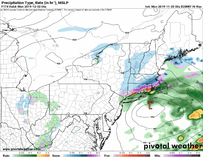
We’ll have a bit of a lull tomorrow morning, but a cold front will approach later in the day, with rain coming back ahead of that front. We’ll still be on the mild side, that is until the front comes through. Temperatures will quickly drop behind the front late Tuesday and Tuesday night but the precipitation may linger, so we will likely see rain changing to snow Tuesday night.

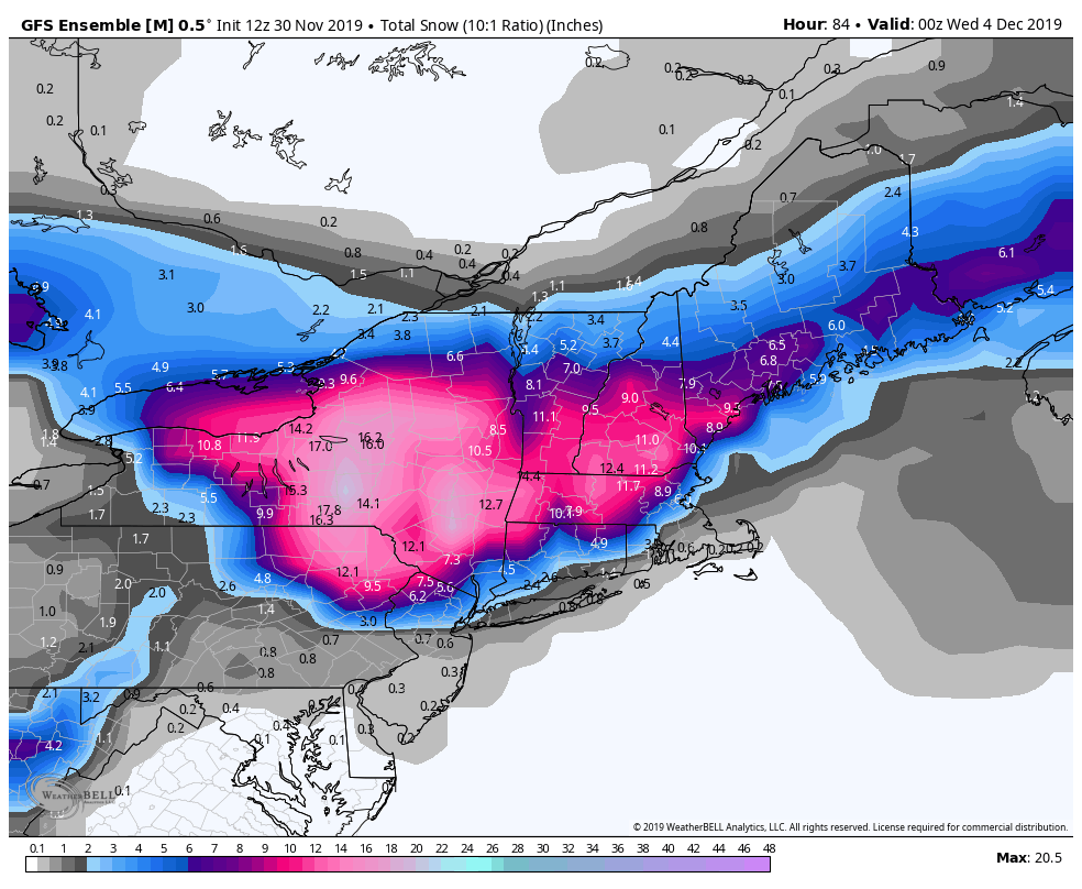
On Wednesday, a little disturbance will move across the region, bringing us some additional light snow, mainly in the morning. There’s still a bit of uncertainty with this, but plan on the morning commute being impacted. We’re probably only looking at a few inches, but all it really takes to screw up the morning commute is a few flakes at all. High pressure builds in late in the day and into Thursday with drier and much colder weather.
By Friday, temperatures start to moderate again as the high slides offshore. It’ll still be chilly (it is December after all), but not quite as cold as Thursday. The weekend looks even milder once again, but that’s because we’ll have another storm system passing to our north and west, so we’re looking at another round of rain, possibly heavy once again.
Monday: Cloudy and becoming breezy with periods of rain and showers. High 49-56.
Monday night: Cloudy and breezy with rain likely, possibly heavy at times, tapering off late at night. Temperatures hold steady or possibly rise a few degrees.
Tuesday: Cloudy and breezy with showers redeveloping late in the day. High 53-60, but temperatures start to quickly drop from northwest to southeast during the afternoon.
Tuesday night: Cloudy with rain changing to snow during the evening. Low 26-33.
Wednesday: Cloudy with light snow ending around midday. Skies clear out at night. Temperatures hold steady or drop a few degrees during the day.
Thursday: Plenty of sunshine, but cold. High 24-31.
Friday: Becoming mostly cloudy. High 32-39.
Saturday: Cloudy, breezy, and milder with rain likely. High 46-53.
Sunday: Partly to mostly cloudy and breezy, chance for a few showers. High 42-49.