This week’s outlook is a lot like last week’s. Dry weather during the week thanks to a large area of high pressure, then questions for the weekend.
For Monday through Friday, we’ve got a large area of high pressure in control. We’ll still have plenty of clouds around on Monday as an upper-level low pressure system moves across the Northeast. Clouds may linger into Tuesday, and with a northerly flow, we could even see some ocean-effect snow showers across the Outer Cape late Tuesday and Tuesday night. Not much accumulation is expected, but a few spots on the Outer Cape could see an inch or so. Wednesday through Friday will feature partly to mostly sunny skies, with chilly temperatures for Wednesday and Thursday, and some moderation on Friday.
Some ocean-effect snow is expected across the Outer Cape Tuesday night. Image provided by WeatherBell.
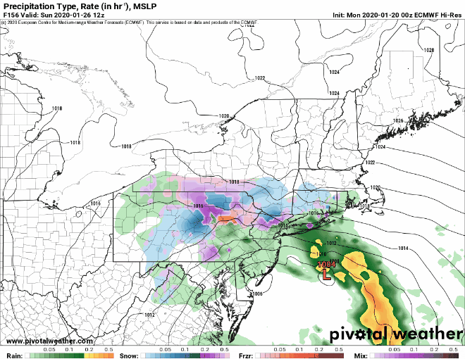
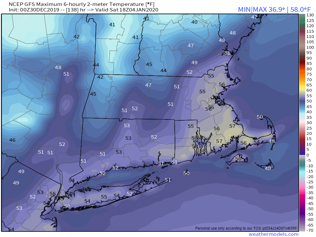
That brings us to next weekend. Once again, many of the models are showing the potential for a storm to impact the region. Some of the models even have it as a powerful storm. Once again, they aren’t anywhere close to agreement on the track of this system though. Some have a storm so far offshore that it will have little to no impact on us. Some have it so close that we get moderate to heavy snow inland with rain across southeastern New England. Others have it just far enough offshore to impact only areas south of Boston. On top of that, many of these models haven’t been consistent from one run to the next.So, once again, we’ll just wait and see what develops. If it looks like it could be a threat, we’ll have a special blog post later in the week.
The various members of the ECMWF Ensemble show that wide variety in forecasts for the potential storm system off the East Coast next weekend. Image provided by Weathermodels.com
Monday: More clouds than sunshine. High 38-45.
Monday night: Partly cloudy. Low 25-32.
Tuesday: Partly sunny, except mostly cloudy across Cape Cod with some late-day snow showers possible. High 34-41.
Tuesday night: Partly to mostly cloudy, some snow showers are possible across Cape Cod. Low 18-25.
Wednesday: Becoming partly to mostly sunny. High 31-38.
Thursday: Plenty of sunshine. High 30-37.
Friday: Partly to mostly sunny. High 36-43.
Saturday: Cloudy with a chance of snow or rain. High 36-43.
Sunday: Cloudy with a chance of snow or rain. High 37-44.
We’ve actually got a quiet week coming up. The weekend might not be quiet, but we don’t have much to worry about before then.
The week is starting off on a chilly note with wind chills near or below zero this morning. Image provided by Weathermodels.com.
A large area of high pressure will build in and remain in control through Friday. That means we’ll have dry and chilly conditions through Wednesday, but as the high slides off to the east, temperatures will moderate for Thursday and Friday, likely to above normal levels for late January. That should allow the snow from Saturday’s storm to melt for the most part. The only exception to the dry forecast is across Cape Cod, especially the Outer Cape, where some ocean-effect snow showers are possible today and again on Tuesday.
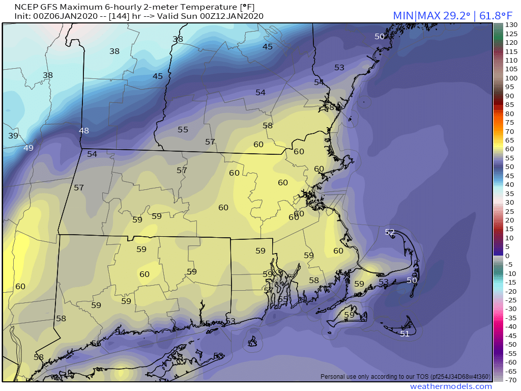
Next weekend, things get complicated again. We’ll have a low pressure system moving towards the Great Lakes and a secondary area of low pressure developing near the Mid-Atlantic states. Some of the models show an upper-level low pressure area moving toward the East Coast at the same time, which would slow down or even stall out that developing surface low. The forecast will obviously depend on the development and track of that low, and at this point, it’s still 5-6 days away, so we’re not even going to attempt to nail down any details. We’ll just say that the potential is there for a long-duration storm that could produce snow or rain (or both). Obviously, the best chance for snow would be farther inland. Assuming this storm develops and looks like it will have a significant impact on the region, we’ll do a special blog post later in the week.
The European (ECMWF), Canadian (GDPS), and American (GFS) models all have different ideas about our potential storm’s location and impacts next Sunday morning. Image provided by Pivotal Weather,
Monday: Partly to mostly sunny, except plenty of clouds across Cape Cod with a few snow showers possible, mainly across the Outer Cape. High 21-28.
Monday night: Clear and cold. Low 8-15, possibly a little colder across southern New Hampshire and into the Merrimack Valley.
Tuesday: Partly sunny, chance for a few snow showers across Cape Cod, mainly the Outer Cape. High 22-29.
Tuesday night: Clear to partly cloudy. Low 10-17.
Wednesday: Plenty of sunshine, not as cold. High 30-37.
Thursday: Sunshine and a few clouds, milder. High 37-44.
Friday: Partly to mostly cloudy. High 38-45.
Saturday: Cloudy with a chance of snow or rain. High 34-41.
Sunday: Cloudy with a chance of snow or rain. High 36-43.
We’ve got a significant snowstorm on the way to the region for Saturday night. Hang on, we’re being told that even though the last week or so has felt like January in North Carolina, we’re still in Massachusetts, not North Carolina. So, let’s start over. We’ve got some snow on the way for Saturday night, but it shouldn’t be a big deal by New England standards.
Winter Storm Warnings and Winter Weather Advisoies are in effect for much of the Northeast. Image provided by Pivotal Weather.
A cold and very dry airmass is in place across New England to start Saturday, thanks to a high pressure area moving across Northern New England. Temperatures are starting the day in the single numbers and teens, with dewpoints near or below zero. Meanwhile, a storm system will be moving out of the Great Lakes and heading for Northern New England later today. That will be out weather-maker for tonight and early Sunday.
Saturday is starting on a very chilly note across the region. Image provided by Weathermodels.com
We’ll see high clouds start streaming in by midday, and they’ll thcken up during the afternoon. It’ll take some time for the air to moisten up, but it will eventually, and snow will start falling right around dinnertime for most of us, a little earlier to the west. This will be a fast-moving storm, with the snow actually tapering off and ending around midnight. It looks like any rain/snow line will be confined to southeastern Massachusetts and Rhode Island. After midnight, a little freezing drizzle or some flurries are possible as the system starts to pull away, but the accumulating snow should be all done.
Our storm quickly moves across the region this evening and tonight. Loop provided by Tropical Tidbits.
The snow could fall at a decent clip during the evening hours, with some places possibly seeing an inch per hour. So, if you’tre going to be out and about, take it slow and drive carefully. How much snow are we expecting?
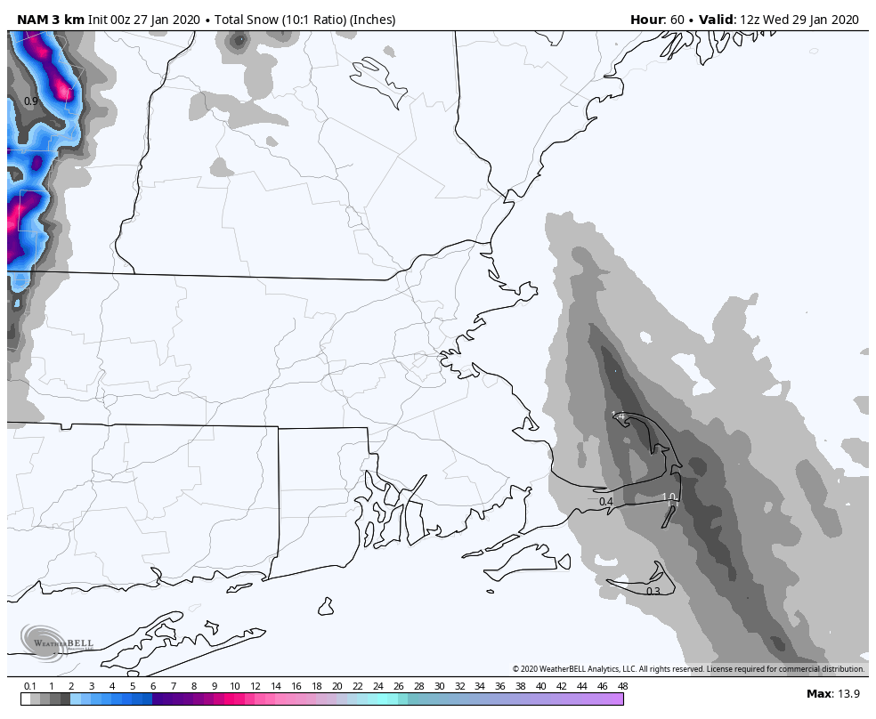
The High-Resolution NAM model is probably closest to our thinking on snowfall with this system. Image provided by WeatherBell.
Behind the storm, Sunday will be a nice day, with developing sunshine and temperatures in the 30s to near 40, which will help melt some of the new snow. You’d better get out and clean up the driveway though, because everything is going to freeze solid Sunday night as another arctic airmass settles into the region. Temperatures may not get back above freezing until Wednesday afternoon, possibly not until Thursday, but a warmup is expected for the end of the week.
We hope you enjoyed the warm weekend, because in case you forgot, it’s January. Don’t worry, Mother Nature will remind you as the week goes on.
More high temperature records were broken or tied along the Eastern Seaboard on Sunday before the cold front moved through. Some of these of these high temperatures were occurred during the early morning hours before sunrise. pic.twitter.com/HI8bCAz8QR
Record highs were smashed across the Northeast again on Sunday, but a cold front moved through during the afternoon, ending the warmth. Temperatures will still be near to above normal for the next few days, but the 60s and 70s are gone. High pressure builds into Quebec today, but there will be plenty of clouds around thanks to northeast winds off of the ocean. In fact, we could see a few flurries or snow showers, especially along the coast from Plymouth County up to the New Hampshire Seacoast. Temperatures will be mainly in the 30s, so yes, you’ll need to find your winter clothes again. As the high slides off to the east, temperatures will start to moderate again on Tuesday, but a weak system will also be moving in. This system will produce a little light rain Tuesday night, maybe mixed with some snow from the Merrimack Valley into Southern New Hampshire.
The High Resolution NAM model shows the potential for coastal snow showers today, and then the system for late Tuesday as well. Loop provided by Weathermodels.com
Behind that system we’ll have some clearing on Wednesday with mild temperatures, but clouds quickly come back late in the day ahead of yet another system. This system also doesn’t look like a big deal, but it could produce a little more in the way of precipitation late Wednesday night into Thursday, with a better chance for some light snow mainly north of the Mass Pike.
Once that system pulls away, gusty winds will usher much colder air into the region for Thursday night and Friday. You’ll be wishing for the 60s and 70s again, as temperatures will likely stay in the 20s on Friday, with wind chills in the single digits and teens.
Wind chils will start the day on Friday in the single numbers and won’t get that much higher in the afternoon. Image provided by WeatherBell.
By Friday night, low pressure will be starting to move out of the Ohio Valley towards the East Coast, and it will likely impact us from Saturday into Sunday. Right now, most of the models have the system track very close to or right across southern New England, but the timing is still in question (along with many other aspects of this potential storm). It’s still 5-6 days away, so things can and will change, but obviously we’ll need to keep an eye on this. Right now, the models are showing the potential for snow, changing to rain at least south of the Mass Pike, possibly farther north. We’re not going to get into many more details than that at this point, but suffice to say, if you have plans on Saturday, keep an eye on the forecast, as the potential exists for a snowstorm, possibly a significant one. Behind the storm, windy and even colder weather settles in on Sunday, and remains in place for much of next week.
Temperatures look like they’ll be well below normal next week. Image provided by WeatherBell.
Monday: Partly to mostly cloudy with a chance for some snow showers or flurries along the coast. High 34-41.
Monday night: Partly to mostly cloudy. Low 26-33.
Tuesday: More clouds than sunshine. High 37-44.
Tuesday night: Mostly cloudy with some showers likely in the evening, possibly mixed with snow from the Merrimack Valley into Southern New Hampshire, some partial clearing possible late at night. Evening low 31-38, then temperatures hold steady or rise a bit overnight.
Wednesday: Mostly sunny, but clouds start to return late in the day. High 42-49.
Thursday: Partly to mostly cloudy and windy with a chance for showers during the morning, possibly some snow showers from southern New Hampshire into northern Massachusetts. High 38-45.
Friday: Sunshine and a few clouds, breezy, and colder. High 21-28.
Saturday: Cloudy and windy with a chance of snow, possibly changing to rain, especially south of the Mass Pike. High 28-35 north of the Mass Pike, 36-43 south of the Mass Pike.
Sunday: Snow or snow showers ending early, then clouds give way to some afternoon sunny breaks, windy. High 27-34.
We’ve got a little bit of everything coming this week – snow, rain, cold and mild temperatures. Let’s get right to the details.
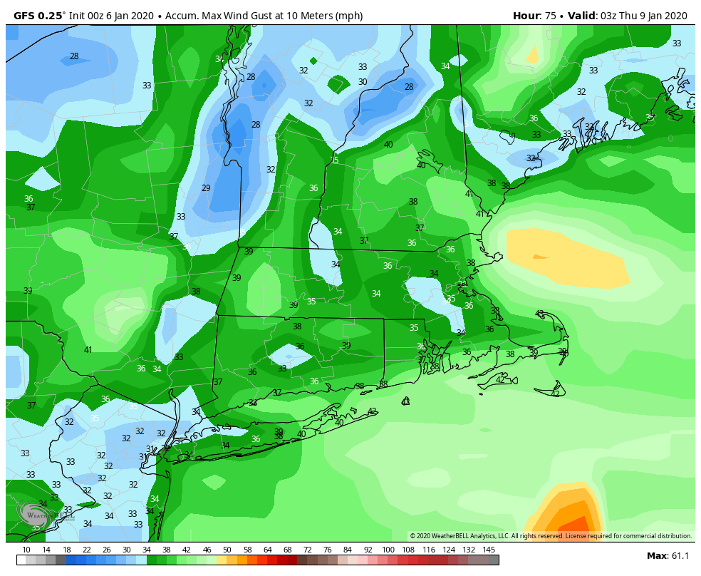
A weak system moves across the region today, bringing in some snow showers, which will probably be just rain showers across southeastern Massachusetts and Rhode Island. This is not a big deal for early January. Skies will clear out behind the system tonight, but that will be short-lived, as clouds quickly come back in on Tuesday ahead of the next storm system. This one will also bring in some light snow, mainly south of the Mass Pike Tuesday night into Wednesday, with some rain possible across Cape Cod. Again, this doesn’t look like a big deal, but some places could see an inch or two of accumulation. The bigger story will be strong winds behind the system, which may gust to 40 mph.
Wind gusts of 30-40 mph will usher much colder air into the region Wednesday night. Image provided by WeatherBell.
High pressure builds in again for Thursday with much colder conditions, but then again, it’s January, it’s supposed to be cold. High temperatures may struggle to get to freezing across much of the area. Again though, this will be short-lived. A warm front moves through on Friday, with a little bit of precipitation ahead of it. This should be mainly in the form on rain, but a little sleet or freezing rain is possible across the interior. Much milder weather settles in behind the front later Friday into Saturday. Temperatures on Saturday could get into the 50s across the area. The problem is, we’ll have some rain to deal with, possibly a quite a bit of it, as a cold front will be approaching. The front moves through Saturday night, but the precipitation could linger into early Sunday. With colder air moving in, and precipitation hanging around, the potential will be there for some wintry weather, especially from the Merrimack Valley into Southern New Hampshire. Right now, it looks like the cold air will be slow to move in, so the precipitation will likely end as rain across the rest of the area. We’ll keep an eye on this as the week goes on.
Highs in the 50s on Saturday? It’s a possibility. Image provided by Weathermodels.com
Monday: Mostly cloudy with some snow showers likely, rain showers across southeastern Massachusetts. High 30-37.
Monday night: Becoming mostly clear. Low 23-30.
Tuesday: Morning sunshine, then clouds stream back in during the afternoon. High 33-40.
Tuesday night: Cloudy with light snow likely, mainly south of the Mass Pike, possibly mixed with rain across Cape Cod. Low 23-30.
Wednesday: Light snow ends early, then some clearing takes place in the afternoon, becoming breezy. High 32-39.
Thursday: Sunshine starts to fade behind increasing afternoon clouds. High 23-30.
Friday: Cloudy, breezy, and milder with a chance for a few showers, possibly mixed with a little sleet across the interior. High 43-50.
Saturday: Cloudy and windy with periods of rain and showers. High 50-57.
Sunday: Rain ends in the morning, possibly as a wintry mix from the Merrimack Valley into Southern New Hampshire. Temperatures will start the day in the middle to upper 30s (lower 40s south of Boston), then hold steady or drop during the afternoon.
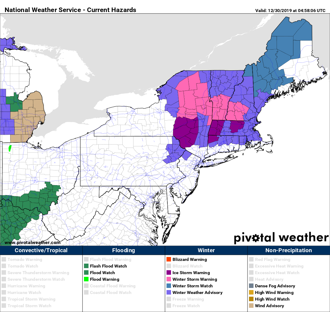
Another year has come and gone, but before we get to New Year’s Eve, we’ve got quite a mess to deal with today.
A variety of Advisories and Warnings are in effect across the Northeast today. Image provided by Pivotal Weather.
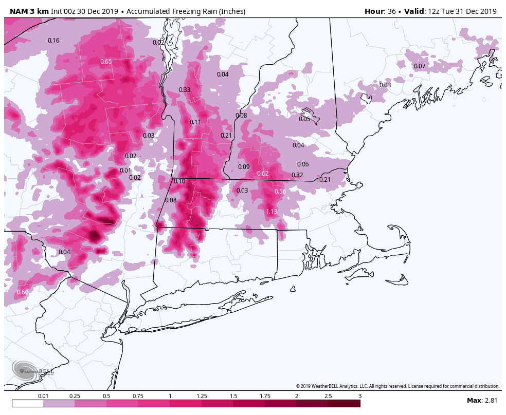
Low pressure will move into the Great Lakes today, with a frontal system extending eastward to the Mid-Atlantic coastline. This will keep us on the cold side, but warmer air will move in aloft. When you have warm air aloft, cold air below, and precipitation, you get sleet or freezing rain, depending on how thick the layers of warm and cold air are. For today, we’re looking at freezing rain across the higher elevations of Worcester County up into the Monadnocks, with a mix of sleet and some freezing rain from southern New Hampshire into the Merrimack Valley and interior portions of eastern Massachusetts. This will result in significant travel problems, not to mention the potential for tree and power line damage. For the rest of our area (mainly south and east of I-95), warmer air moving in off the ocean will keep temperatures above freezing, so it’ll be just another rainy, but chilly, Monday.
The potential still exists for some significant sleet accumulations from the Merrimack Valley into Southern New Hampshire today. Image provided by WeatherBell,
A secondary area of low pressure will move off the Mid-Atlantic coastline tonight, and pass across Cape Cod before moving into the Gulf of Maine on Tuesday. This should force the warmer air farther inland, with a change to plain rain for most of the area, though sleet and/or freezing rain will still be likely up into central New Hampshire. As that low moves into the Gulf of Maine on Tuesday, everything will start to wind down in the morning.
Freezing rain will likely cause problems from the Worcester Hills into the Monadnocks and also across the Berkshires today. Image provided by WeatherBell.
As for New Year’s Eve, the original low pressure area from the Great Lakes will pass north of the region, dragging a cold front through. Although it will likely remain dry, a few snow showers or flurries can’t be ruled out during the evening. Skies should be partly to mostly cloudy at night, with midnight temperatures generally in the 30s. An upper-level low will move across the region on New Year’s Day, so we’ll have some clouds, but probably not any flurries, though it will be seasonably chilly. High pressure then builds in for Thursday with sunshine and seasonable temperatures.
The next storm system moves into the Great Lakes Friday into Saturday. Oh great, another ice storm, right? Nope. This time, it looks milder (much milder on some models), so we’re looking at mainly rain, probably not a lot of it though. An early look at the weather for Foxborough Saturday evening (don’t get us started on the fact there will actually be a game this weekend), is for partly cloudy skies, light winds, and temperatures in the lower 40s. Drier and colder air settles in for Sunday.
Highs in the 50s on Saturday? The GFS thinks so, We’re not convinced yet. Image provided by Weathermodels.com
Monday: Breezy with sleet and freezing rain across the interior, rain along the coast. Sleet accumulations of an inch or two are possible across the Merrimack Valley and southern Hampshire, while up to 1/2″ of ice accretion is possible across the higher elevations of the Worcester Hills and the Monadnocks. High 30-37.
Monday night: Precipitation changing to all rain most areas, except sleet and freezing rain continue across central New Hampshire. Temperatures will slowly rise overnight.
Tuesday: Rain tapers off and ends in the morning, some sunny breaks may develop in the afternoon. High 39-46.
New Year’s Eve: Partly cloudy, chance for a snow shower or flurry during the evening. Low 25-32.
New Year’s Day: A mix of sun and clouds, breezy. High 34-41.
Thursday: Sunshine and just a few clouds. High 36-43.
Friday: Cloudy with some light rain or showers likely. High 40-47.
Saturday: A cloudy start, then becoming partly sunny. High 48-55.
Sunday: Intervals of clouds and sunshine. High 36-43.
As we head into the home stretch of 2019, it looks like the year is going to end with a wintry mess.
Winter Storm Watches are in effect across interior portions of New England and eastern New York. Image provided by Pivotal Weather.
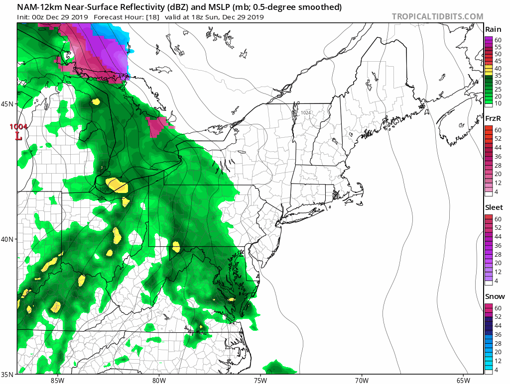
The storm system that produced heavy snow in the Plains and strong to severe thunderstorms in the Mississippi Valley on Saturday will head into the Great Lakes on Sunday, then just mill around in the Midwest for Monday and early Tuesday. Clouds will stream into our area later Sunday ahead of the system, but as is usually the case with a storm that far west, the warmer air that we usually find on the east side of a storm system won’t make it in here, at least at the surface (that becomes important later on).
Sunday will be a mild day (by late December standards) as high pressure moves out, but temperatures should drop below freezing during the evening. We’ll see precipitation start to break out before midnight across much of the area. While there will still be cold air in place at the surface, warmer air will be starting to move in aloft. So, we should see sleet and some freezing rain developing, with some snowflakes, mainly from central and southern New Hampshire northward. Some accumulations are possible, especially from the Seacoast up into the Lakes Region, but only a few inches at most before a change to sleet occurs. Along the South Coast, this will be mainly rain with temperatures above freezing.
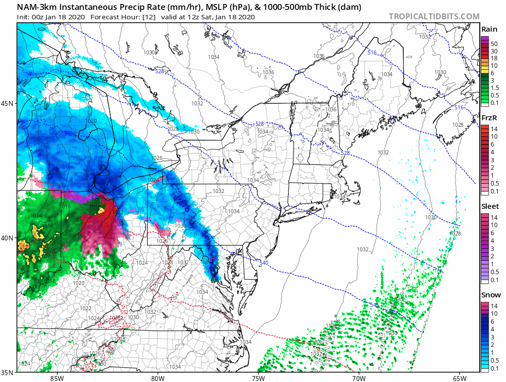
The NAM model shows the progression of the storm system and how the precipitation changes from sleet to freezing rain, to rain across the region. Loop provided by Tropical Tidbits,
With a frontal system stalled out south of New England, we’ll have generally east to northeast winds on Monday. This will allow parts of southeastern Massachusetts and Rhode Island (mainly south and east of Interstate 95), to warm above freezing as somewhat milder air moves in off the ocean. Across inland areas, it’ll be a much different story.
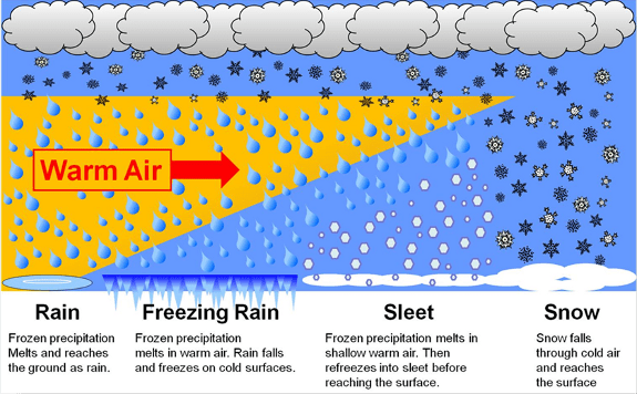
This graphic shows the difference in how you get snow vs sleet vs freezing rain. Image provided by NOAA.
Cold air will remain in place for most of the day on Monday and into Monday night. Meanwhile, a few thousand feet above the ground, warmer air will be moving in. This will mean sleet at first, but as that warmer air layer grows thicker, the sleet should transition over to freezing rain. When that transition occurs is still a bit of a question mark.
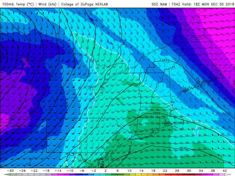
NAM model forecast for temperatures at 700mb (about 10000 feet) for midday Monday. Temperatures will be above freezing across most of our region that high up, melting any high-level snowflakes falling into that part of the atmosphere. Image provided by the College of DuPage.
Some models are showing the potential for significant amounts of sleet from interior eastern Massachusetts into southern New Hampshire, with significant ice accretion from freezing rain across the Worcester Hills, Monadnocks, and the Berkshires. No matter what happens, travel will be very slippery across the interior on Monday,
The High-Resolution NAM model is forecasting a LOT of skeet across the interior. Image provided by WeatherBell.
By Monday night, a secondary area of low pressure should develop south of Long Island, and it will head northeast, moving across Cape Cod early Tuesday, then into the Gulf of Maine. As it moves close to the area, it should help force the warm air farther inland, allowing temperatures to rise above freezing across most of the area. However, once it moves into the Gulf of Maine, colder air will settle in behind it, both at the surface and aloft, changing everything back to snow showers before the precipitation winds down Tuesday morning.
Significant ice accretion could result in major issues including tree and power line damage across the interior. Image provided by WeatherBell.
We’ll update this forecast as well as a look at New Year’s Eve and New Year’s Day in our Weekly Outlook early Monday morning.
As we get to Christmas Week, we’ve got a very quiet pattern shaping up for the region. That doesn’t mean the forecast is simple though.
We start the week off on a mild note with high pressure still in a control, but a weak cold front will move through late in the day with little fanfare. It’s most noticeable impacts will be behind it, as temperatures drop back close to seasonal levels for Christmas Eve and Christmas Day, with highs in the 30s instead of the 40s to lower 50s most places will enjoy today.
Much of the area could see temperatures top 50 this afternoon. Image provided by WeatherBell.
Thursday looks to be a tad milder, but we’ll have a weak disturbance moving across the region. It may produce a few rain or snow showers late Thursday night into part of Friday, but this will not be a widespread precipitation-maker. High pressure builds back in for Friday night into Saturday before we turn out attention to the next storm. This one also has some big questions, but for now, it looks like we could have some rain around here next Sunday:
Monday: Sunshine gives way to some late-day clouds. High 46-53.
Monday night: Cloudy in the evening, then clearing after midnight. Low 25-32.
Christmas Eve: Partly to mostly sunny and cooler. High 35-42.
Christmas Eve night: Becoming partly to mostly cloudy. Low 18-25.
Christmas Day: Sunshine filtered through some high clouds. High 34-41.
Thursday: More clouds than sun. High 34-41.
Friday: Plenty of clouds with a few sunny breaks, chance for a few snow or rain showers early. High 34-41.
Saturday: Intervals of clouds and sunshine. High 39-46.
The Winter Solstice is Saturday, but winter will certainly make it’s presence felt over the next few days.
The low pressure system that produced severe weather across the South on Monday will head northeastward, impacting our area on Tuesday. The storm will be moving fairly quickly, and it doesn’t have a lot of cold air to work with, so we’re not expecting a big snowstorm. That doesn’t mean it won’t cause any problems.
Winter Weather Advisories are in effect for most of the region. Image provided by Pivotal Weather.
Snow will develop around midnight across parts of Connecticut and Southern Rhode Island, gradually spreading northward across the rest of the region before daybreak. The snow should quickly change to rain after daybreak across the South Coast and Cape Cod. As warmer air moves in aloft, a change to sleet and freezing rain will start to take place across the interior, with plain rain along the coast as milder air moves in off the still relatively mild ocean. Right now, it looks like the mixing may get as far north as the Merrimack Valley during the afternoon. North of there, precipitation should stay all snow. The precipitation will lighten up during the afternoon, but won’t completely end until the evening or first part of the overnight.
The morning and evening commute will both be impacted by this storm, but the greater impacts will certainly be during the morning commute. Not only could icing be a problem, especially in parts of Connecticut and Rhode Island, we could be looking at a band of moderate to heavy snow along and south of the Mass Pike. With temperatures expected to drop below freezing at night, many roads could ice back up, so untreated surfaces could become slick, especially in areas that changed over to rain during the afternoon.
Icing could become a significant problem across parts of Connecticut and Rhode Island on Tuesday. Image provided by Pivotal Weather.
As for how much snow to expect, we haven’t changed our thinking much from our earlier forecast.
South Coast/Cape Cod: Less than 1″ Southeastern Massachusetts (including the I-95 corridor): 1-2″ MetroWest/North Shore: 1-3″ Merrimack Valley: 2-4″ Central + Southern New Hampshire/NH Seacoast: 3-6″
The High Resolution NAM model is probably closest to our expectations for snowfall. Image provided by WeatherBell.
Behind this system, we’ve got to pay attention to an arctic cold front that will move across the region late Wednesday. It could produce some snow showers or squalls as it moves through. These won’t impact everyone, but in places they do, visibility could rapidly drop, and a quick half an inch to an inch of snow could fall.
Wind chills will likely drop below zero across most of the area Wednesday night into Thursday morning. Image provided by Weathermodels,com
Behind that front, some of the coldest air so far this season will settle in for Thursday. Wind chills will be below zero during the morning hours, and actual temperatures may not make it out of the teens during the afternoon. Friday will see temperatures start to moderate a bit, but it will still remain quite chilly, even by December standards.
We’ve got another week coming up with just about everything Mother Nature has to offer. Well, not quite everything, since we won’t have a warm day this week. To make up for it, we’ll have at least one day that is extremely cold. How’s that for a trade off?
The week starts off with high pressure in control. That means we’ll have some sunshine, less wind, and chilly temperatures today. The sunshine will not last long though, as clouds quickly move in ahead of our next system. That storm will move from the Tennessee Valley into the Mid-Atlantic states, passing south of New England on Tuesday. That’s about the only part of the storm that isn’t complicated.
Snow will develop across much of the region before daybreak on Tuesday. Yes, that means your morning commute on Tuesday will be even worse than normal. The snow should quickly change to rain along the South Coast. Away from the coast is where the problems start. Warmer air will move in aloft, with a change to sleet, freezing rain, and eventually plain rain expected to work its way northward on Tuesday. How quickly it moves northward, and how far north that changeover gets are still up in the air. Obviously, this has a major impact on how much snow accumulation we can expect. The other problem is, how long do some areas stay sleet or freezing rain, as this will have a significant impact on road conditions.
The High-Resolution NAM model shows the progression of the the precipitation and changeover line with the next storm system. Loop provided by WeatherBell.
So, how much snow can we expect before the changeover? Obviously, this is still a low-confidence forecast, despite the fact that it’s only a little more than a day away. Here’s what we’re thinking for now:
South Coast/Cape Cod: Little to no accumulation Southeastern Massachusetts/Rhode Island (South and East of I-95): A coating to 2 inches. Northern Rhode Island/MetroWest/North Shore/Merrimack Valley/NH Seacoast: 1-3″ Southern NH (Nashua-Manchester): 2-4″ Central NH (Concord-Lebanon): 4-7″
We’ll try to do an updated blog post late Monday, once we get a little more clarity on some of the details.
The GFS model is probably the closest to our thinking for snowfall amounts right now. Image provided by Weathermodels.com
So, everything winds down Tuesday evening, and then things improve on Wednesday, right? Not so much. A strong cold front will move across the region during the afternoon. This front may produce some snow showers or possibly snow squalls as it moves through during the afternoon and evening. Behind the front, some much colder air settles in for Wednesday night and Thursday. Now, it won’t be as cold as it was in the Dakotas and Minnesota, where it stayed below zero all day Saturday and Sunday (Can someone please explain why people choose to live in North Dakota?), but many parts of our area could stay below 20 all day on Thursday. When you fact in the wind, it will feel like it’s below zero, especially during the morning.
Heading out before daybreak Thursday? Bundle up, because wind chills will likely be below zero across the region, Image provided by WeatherBell.
High pressure builds in for Friday with dry weather, but it shouldn’t be as cold as Thursday. This brings us to the weekend. This is where things get questionable again. You may have heard some chatter online about a big snowstorm this weekend. Well, it’s a possibility, but then again, it’s also possible that the Patriots defense won’t give up a single point for the rest of the season. Most of the models have been signalling that there will be a potent storm system developing off the East Coast this weekend. Every now and then, one of the runs puts that storm right off of Cape Cod and shows the potential for a blizzard, sending all of the Facebook Forecasters into a frenzy. Of course, these same models have also shown the same storm moving off of Florida and then eastward across the Bahamas instead. Will there be a strong storm? Probably. Will it impact us? Probably not. However, one thing that may happen, is a weak system moving eastward bringing in a period of light snow sometime either late Saturday or Sunday. Given where the storm forms, it’s not really an Alberta Clipper, calling it a Dakota Dasher would probably be more accurate.
Nearly every run of the GFS over the past 5 days has had a strong storm near the East Coast this weekend. However, the placement and strength of the storm has varied on every run. Loop provided by Pivotal Weather.
If you’re really looking ahead, right now Christmas Eve and Christmas Day look dry and seasonably chilly.
Monday: Some sunshine early, then clouds thicken up. High 30-37.
Monday night: Cloudy with snow developing after midnight. Low 23-30.
Tuesday: Snow, changing to sleet, freezing rain, and plain rain from south to north. Areas north of the Mass Pike may never go to plain rain. High 27-34 north and west of Interstate 95, 34-41 south and east of Interstate 95.
Tuesday night: Precipitation ends in the evening, then skies clear out late at night. Low 21-28.
Wednesday: Morning sunshine, clouds return in the afternoon with some snow showers or squalls possible late in the day, becoming windy at night. High 30-37.
Thursday: Sunshine and a few clouds, breezy, and cold. High 17-24.
Friday: Partly to mostly sunny. High 22-29.
Saturday: Mostly cloudy, chance for some light snow or snow showers late in the day and at night. High 29-36.
Sunday: Partly to mostly cloudy with a chance of snow showers, especially in the morning. High 34-41.