Drier weather will return for a few days, but won’t last for too long.
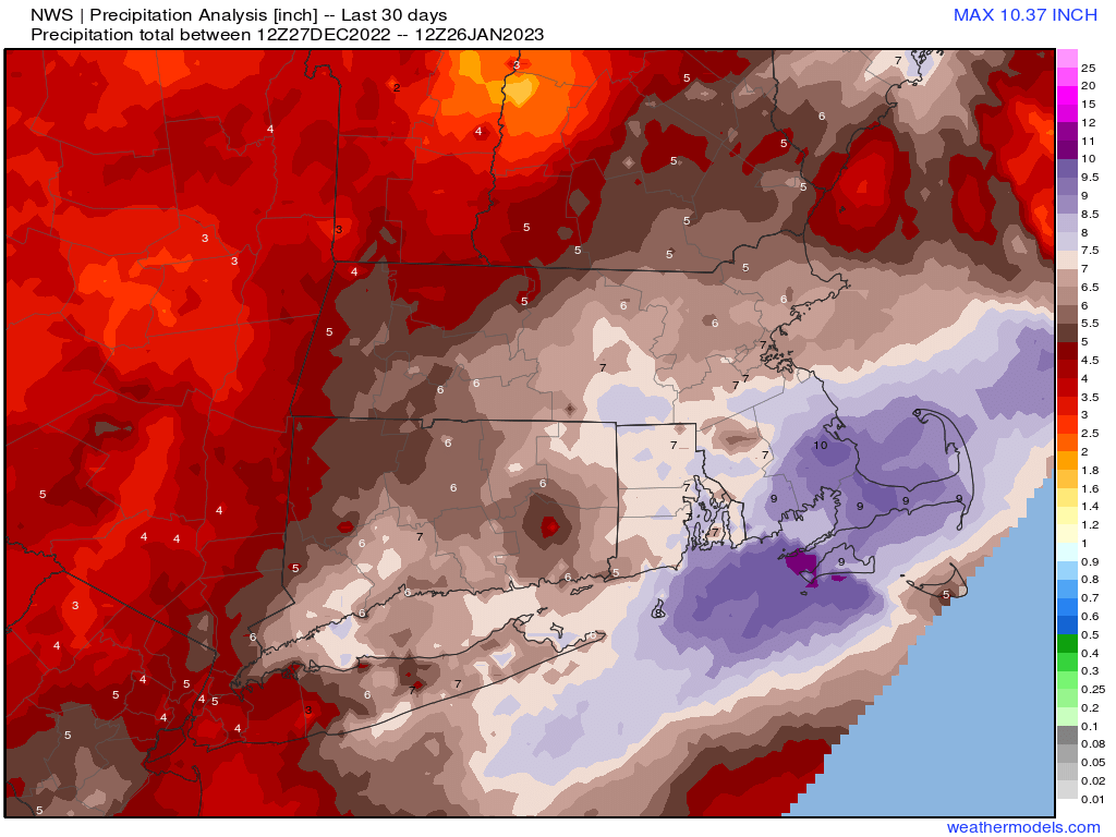
Most of the region has received 5-10 inches of rain (not snow) over the past month. Image provided by Weathermodels.com.
High pressure builds in for tonight and Friday with some clearing and temperatures remaining on the mild side for late January. A weak front will move through on Saturday with some clouds and possibly a rain or snow shower, but for the most part, it will remain dry. The front stalls out just to the south, keeping plenty of clouds around for Saturday night and Sunday. On Sunday it will start moving northward again as a warm front, ahead of low pressure heading toward the eastern Great Lakes. That low passes across Northern New England Sunday night and Monday, producing a few rain or snow showers across our area. We’ll start to clear out behind the system later on Monday.
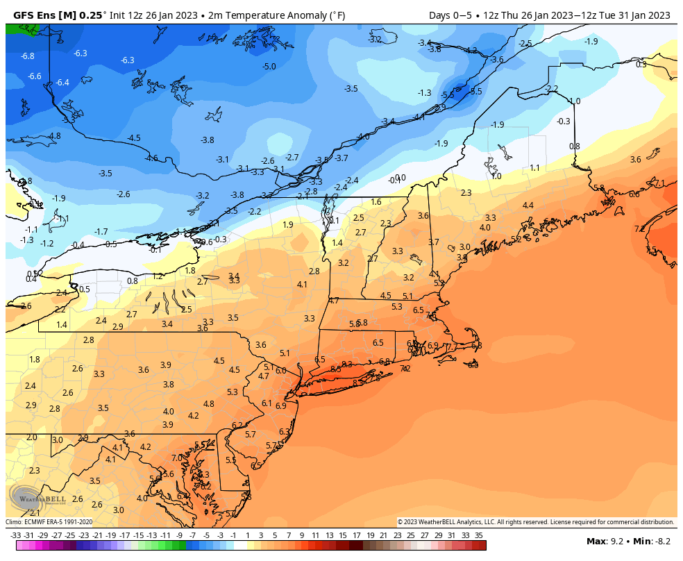
Temperatures will remain above to well above normal over the next few days. Image provided by WeatherBell.
Thursday night: Partly cloudy, breezy. Low 22-29.
Friday: Partly to mostly sunny. High 34-41.
Friday night: Variably cloudy, chance for a few late-night rain or snow showers. Low 21-28.
Saturday: Partly sunny and breezy. High 39-46.
Saturday night: Partly to mostly cloudy. Low 24-31.
Sunday: Mostly cloudy, breezy. High 42-49.
Sunday night: Mostly cloudy, chance for a few rain or snow showers. Low 25-32.
Monday: Plenty of clouds with a few rain or snow showers early, some clearing late in the day. High 39-46.
A fairly active weather pattern is on deck for this week, with several bouts of unsettled weather expected.
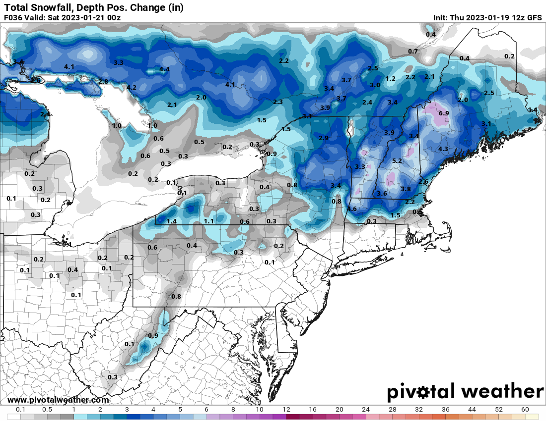
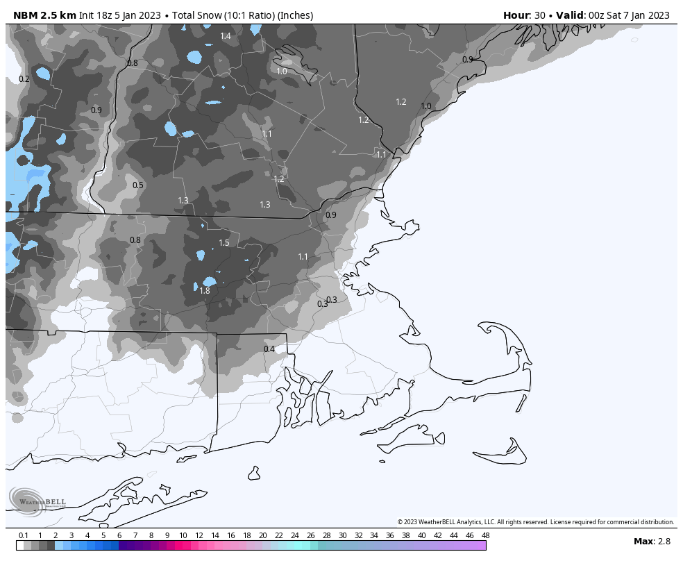
We’re starting the week off on a stormy note with low pressure passing south of the region. Colder air will work its way in behind the storm today, allowing the rain/snow line to move southward as the day progresses. So, even places that are still raining this morning will likely see some snow before the day is out and the storm pulls away. Areas south of the Mass Pike will likely see an inch or less of accumulation, with another 1-3 inches north of the Pike, and possibly a little more than that across southern New Hampshire. Everything ends this evening, then high pressure briefly builds in tomorrow with drier conditions.
Much of the region will only pickup another inch or two of snow today. Image provided by WeatherBell.
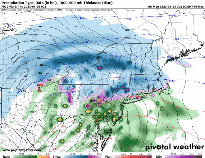
However, another storm will quickly follow for Wednesday. With some cold air in place, this one will likely start as snow across the region Wednesday afternoon, making for a rather messy afternoon commute. However, with the low passing west of us, and a secondary low pressure system developing right overhead, warmer air will move in, resulting in a change to rain Wednesday evening and night, ending Thursday morning. As that system pulls away, breezy and cooler conditions settle in late Thursday into Friday, but a cold front will approach the region on Saturday. That front may produce some snow showers Saturday afternoon and evening before it pushes offshore. Wel clear out behind it and turn colder, but yet another system quickly follows late Sunday, with some rain or snow showers possible late in the day ahead of a warm front.
Most of the models show snow falling for the Wednesday afternoon commute. Images provided by Pivotal Weather.
Monday: Breezy with snow likely north of the Mass Pike, rain changing to snow south of the Pike. High 34-41 early, temperatures drop during the afternoon.
Monday night: Snow ending in the evening, followed by clearing, windy. Low 22-29.
Tuesday: Morning clouds, some afternoon sun, breezy. High 35-42.
Tuesday night: Clear through the evening, clouds return after midnight. Low 17-24.
Wednesday: Cloudy with snow developing in the afternoon, changing to rain from south to north during the evening. High 32-39.
Thursday: Windy with periods of rain, ending in the afternoon. High 39-46 north and west of I-495, 47-54 south and east.
Friday: Partly to mostly sunny, breezy, and colder. High 32-39.
Saturday: Mostly cloudy and breezy with a few snow showers possible, clearing late in the day. High 37-44.
Sunday: Becoming mostly cloudy and breezy, snow or rain showers possible late in the day. High 35-42.
We’re getting into a more active weather pattern around here, and also one that is a bit more wintry.
Tonight’s storm will bring a little bit of everything to the region. Loop provided by Weathermodels.com
Low pressure will head into the Midwest tonight while a secondary area of low pressure develops across the northern Mid-Atlantic states and passes just south of New England tonight. Rain will overspread much of the region over the next few hours, except for central New Hampshire, where precipitation will likely start as some snow. As that secondary area of low pressure passes by to the south tonight, winds will shift into the north, allowing cooler air to settle in, and the rain/snow line to start migrating southward. The steadiest precipitation likely ends before daybreak, but the old low pressure system will move through during the day on Friday, with occasional snow showers north and west of Boston, and occasional rain showers changing to snow showers from Boston southward. The rain/snow line likely doesn’t reach the South Coast before everything winds down late Friday afternoon or evening. How much snow can we expect?
South and east of I-95: Less than 1″ MetroWest/North Shore: 1-2″ Merrimack Valley/NH Seacoast: 2-4″ Southern/Central NH: 3-6″
This will not be a big snowmaker for much of our region. Image provided by Pivotal Weather.
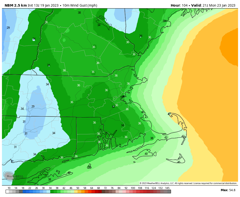
We may see some clearing on Saturday as high pressure tries to move in, but clouds quickly return Saturday night as another system heads toward the region. This one looks to be mostly rain for Sunday night into Monday morning, but it may start as snow across southern New Hampshire, and the rain may change to snow before ending across the region Monday morning. We’ll clear out behind the system Monday afternoon, but it will be quite breezy.
Northwest winds may gust to 30-40 mph Monday afternoon. Image provided by WeatherBell.
Thursday night: Rain developing across the region, except snow across central New Hampshire. Rain changes to snow as we head through the night across southern New Hampshire and the Merrimack Valley. Low 29-36.
Friday: Occasional snow showers north and west of Boston, with rain showers changing to snow showers from Boston southward. High 34-41 in the morning, temperatures drop during the day.
Friday night: Mostly cloudy, any lingering rain or snow showers end in the evening. Low 20-27.
Saturday: Becoming partly sunny. High 30-37.
Saturday night: Clouds return. Low 11-18 across southern New Hampshire and the Merrimack Valley, 19-26 elsewhere.
Sunday: Mostly cloudy. High 36-43.
Sunday night: Cloudy and becoming windy with rain likely, possibly starting as snow across southern New Hampshire. Low 30-37, temperatures may rise a bit overnight.
Monday: Rain may change to snow before ending in the morning, becoming partly sunny and windy in the afternoon. High 40-47 early, temperatures drop during the day.
Despite the snow last night and this morning, temperatures will remain above normal for much of the upcoming week.
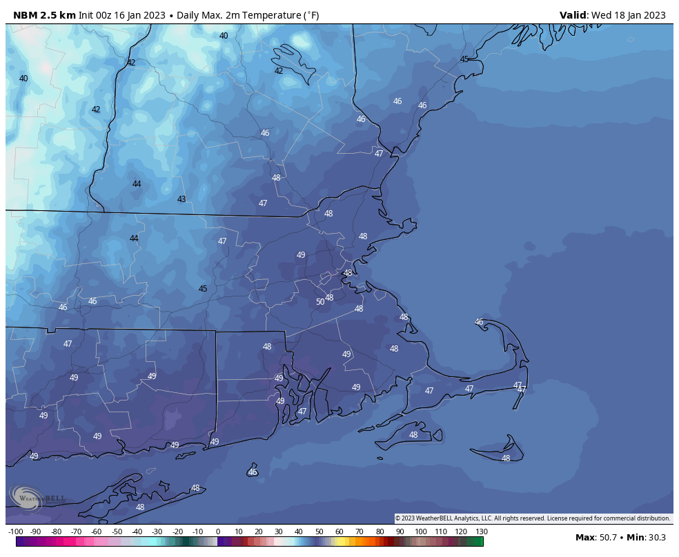
Low pressure slowly pulls away from the region today, with snow lingering near the coast , but the sun may come out as you head westward. Skies should clear out near the coast as well Monday night as the storm finally moves far enough away. Tuesday starts off nice, but clouds return during the afternoon ahead of another fast-moving but weak storm system. A few showers are possible, but temperatures will also turn milder, helping to melt the snow that fell late Sunday and Monday. We’ll start to clear out again on Wednesday as high pressure builds back in with mild temperatures once again.
Temperatures could approach 50 degrees on Wednesday. Image provided by WeatherBell.
The next system moves toward the region on Thursday, and will impact the region late Thursday into much of Friday. While it will be mostly rain, it may start as snow across southern New Hampshire, where some accumulations are possible. The rain may also change back to snow before ending across the region late Friday. High pressure then builds in for next weekend with drier weather.
The models have different ideas as to where the rain/snow line will start off when precipitation moves in late Thursday. Images provided by Pivotal Weather.
Monday: Plenty of clouds, breezy, some sunny breaks inland, snow showers continue near the coastline, tapering off in the afternoon. Additional accumulation an inch or less. High 32-39.
Monday night: Clearing. Low 24-31.
Tuesday: Morning sun, increasing afternoon clouds. High 39-46.
Tuesday night: Partly to mostly cloudy with a few showers possible. Low 29-36.
Wednesday: Becoming partly to mostly sunny. High 44-51.
Thursday: Becoming cloudy, showers developing late in the day, possibly starting as snow north and west of Boston before changing to rain at night. High 37-44.
Friday: Cloudy with showers ending, possibly as wet snow, especially north and west of Boston. High 36-43.
Saturday: A mix of sun and clouds, chance for a few snow showers. High 35-42.
What seemed like a relatively simple forecast just a day or two ago suddenly is a bit more complicated for parts of the region.
Low pressure currently in the Ohio Valley will pass north and west of the region on Friday. A warm front ahead of the system will move through tonight, accompanied by some showers this evening which will become a steadier rain overnight. Temperatures will also rise behind the warm front tonight. By the time you wake up on Friday, temperatures should be in the lower to middle 50s, but won’t go up any further. A cold front will move through during the morning, and it will bring an end to the rain, but temperatures will start falling in the afternoon behind the front. That front will likely stall out once it gets offshore, keeping plenty of clouds around, especially closer to the coast. Saturday looks to be a cloudy, cooler, and drier day across the region.
Some heavy rain is possibly across the region tonight and Friday morning. Iage provided by Weathermodels.com.
Late Saturday is where the uncertainty comes into the forecast. A wave of low pressure will begin riding up the stalled out front offshore. How close it comes to the Cape and Islands varies by which model you look at, which has an impact on the forecast. Some models keep the system well offshore, with little to no impact on us. Some models bring it close enough for some rain or snow showers across the Cape and possibly southeastern Massachusetts, and some bring in steadier snow to parts of eastern Massachusetts. No matter what track it takes, gusty north to northeast winds will probably also generate some ocean-effect snow across parts of Cape Cod and possibly Plymouth County. For now, we’re leaning toward the middle ground of the model scenarios, but obviously will keep a close eye on how things progress. High pressure builds in behind the system Sunday night into Monday with dry and cool conditions.
Some snow is possible across parts of southeastern Massachusetts this weekend, depending on which model you believe. Images provided by Pivotal Weather.
Thursday night: Periods of rain, breezy. Temperatures slowly rising overnight.
Friday: Rain ending by early afternoon, remaining cloudy. High 50-57 in the morning, temperatures drop in the afternoon.
Friday night: Mostly cloudy. Low 27-34.
Saturday: Plenty of clouds, possibly a few breaks of sunshine. High 34-41.
Saturday night: Cloudy, chance for some snow or rain showers across Cape Cod and southeastern Massachusetts. Low 22-29.
Sunday: Snow showers possible across Cape Cod and southeastern Massachusetts, some clearing late in the day. High 32-39.
Quiet weather is expected for much of the upcoming week once again, but that doesn’t mean the entire week will be storm-free.
By mid-week, temperatures will be fairly close to normal for mid-January. Image provided by Weathermodels.com
We start the week off with a very weak system passing by to the south. It spread some clouds in, with a few rain or snow showers possible across southeastern Massachusetts and the Cape and the Islands this morning. We’ll start to clear out in the afternoon as high pressure starts to build in. Some sunshine and seasonably cool temperatures are expected on Tuesday, and even into Wednesday, but during the Wednesday we’ll see some clouds start to move in as low pressure begins heading toward the Midwest. There’s some disagreement among the models on the evolution of this storm, but at this point, it looks likely to be mainly a rainstorm around here, with only a little wet snow possible on the front end of the storm across parts of southern New Hampshire. There’s also some disagreement on the timing of the storm, but right now at least, it looks like it’ll be late Thursday into Friday. There’s some disagreement for Saturday as well. Some of the models have a secondary storm move up the cast, possibly bringing in some more rain or snow, others just have an upper-level disturbance move through with some clouds and a few rain or snow showers. We’re going to lean toward the drier scenario for now, but that can obviously change. High pressure builds in for Sunday.
There’s quite the range of scenarios on Saturday depending on which model you look at. Images provided by Pivotal Weather.
Monday: Morning clouds, maybe a rain or snow shower across Southeastern Massachusetts and the Cape and Islands, clearing in the afternoon. High 36-43.
Monday night: Clear to partly cloudy. Low 23-30.
Tuesday: A mix of sun and clouds. High 34-41.
Tuesday night: Partly cloudy. Low 18-25.
Wednesday: Partly sunny, clouds thicken up late in the day. High 33-40.
Thursday: Cloudy with rain likely late in the day and at night, possibly starting as some wet snow across southern New Hampshire. High 37-44.
Friday: Rain tapers off to showers and ends. High 46-53.
Saturday: More clouds than sun, chance for a rain or snow shower. High 39-46.
The weather pattern will start to quiet down again this weekend, but not before some of us get some snow on Friday.
Drizzle and fog (and a little freezing drizzle) will gradually taper off tonight as a cold front continues to push offshore. An upper-level system quickly follows for Friday. With colder air in place, precipitation will be mainly in the form on snow north and west of Boston, while areas near the coast and south of Boston likely see mostly rain, with some snow mixed in, especially as everything winds down. Snow likely develops during the late morning hours and ends during the evening. It should be mostly light, but some bursts of moderate to perhaps heavy snow are possible. For accumulations, south and east of I-95 will have some slush at most. Areas north and west of I-95 are looking at a general 1-2″ with some spots possibly picking up 3-4″ if these heavier bursts do materialize. We’ll still have some clouds around on Saturday, then we should clear out for Sunday and Monday with seasonably chilly conditions expected.
Friday’s snow shouldn’t be a big deal, especially as you get closer to the coast. Image provided by WeatherBell.
Thursday night: Plenty of clouds, drizzle and fog linger, especially during the evening. Low 31-38.
Friday: Mostly cloudy, light snow developing north and west of I-95, rain south and east, possibly changing to snow late in the day. High 35-42.
Friday night: Snow and rain end in the evening, then skies become partly cloudy. Low 27-34.
Saturday: Intervals of clouds and sunshine. High 36-43.
This week will start and end with quiet weather, but in between will be interesting.
High pressure provides the region with dry and mild weather today, though not as mild as the past few days. Clouds will start to move in tonight ahead of a low pressure system moving into the nation’s midsection. A warm front will approach on Tuesday, with some light rain and showers likely ahead of it during the afternoon and evening. Much warmer air will move in behind the front for Tuesday night and Wednesday, but the question becomes – how far north does the front get before stalling out. South of the front, temperatures will get well into the 50s or even 60s on Wednesday, but to the north, it will stay in the 40s. At this point, it looks like the front should get north of the Mass Pike and to at least Route 2 and possibly the MA/NH border. Whether it gets farther than that is debatable, or if it even gets that far. Another round of showers is likely Wednesday afternoon and evening as a cold front approaches. The warm front will also begin dropping southward again as a backdoor cold front. Temperatures will drop rapidly once that passes, so timing it correctly will be critical to the forecast. Most of the models have it move through during the evening or at night, but some have it as early as mid-afternoon.
There are significant differences among the models as the how far north the warm air gets on Wednesday. Images provided by Pivotal Weather.
Once the cold front moves through and temperatures start dropping, we could see a change to freezing rain and sleet across the interior late Wednesday night into early Thursday. Another low pressure system passes south of the region later Thursday into early Friday, which may produce some snow across the area, with accumulations possible, especially across the interior. High pressure then builds in for the weekend with drier conditions and seasonably chilly temperatures.
A little snow is possible Thursday night and Friday morning. Image provided by WeatherBell.
Monday: A mix of sun and clouds. High 43-50.
Monday night: Clear skies through the evening, clouds increase overnight. Low 28-35.
Tuesday: Cloudy with light rain and showers developing. High 36-43 north of the Mass Pike, 44-51 south of the Pike.
Tuesday night: Cloudy with a few showers or some drizzle. Temperatures hold steady or rise overnight.
Wednesday: Cloudy, showers redevelop in the afternoon, possibly changing to freezing rain or snow overnight, mainly across southern New Hampshire. High 51-58, possibly much cooler across southern New Hampshire.
Thursday: Cloudy and breezy with some snow showers possible during the day, steadier light snow possible at night. High 37-44.
Friday: Cloudy with a chance for some light snow, mainly in the morning. High 34-41.
We’ve endured plenty of chilly Frist Night celebrations over the years around there. This year won’t be one of them.
Temperatures will average 10-15 degrees normal over the next few days. Image provided by WeatherBell.
High pressure slides offshore tonight and Friday, with dry and mild conditions expected. Clouds start to stream in Friday night ahead of a low pressure system moving this way. Saturday will be another mild, albeit cloudy, day. Showers will develop toward evening, becoming a steady rain overnight. So, if you’re heading out to celebrate New Year’s Eve, bring a raincoat. The rain should come to an end New Year’s morning, then skies clear out during the afternoon as the low pulls away and high pressure builds back in. For Monday, we should have partly to mostly sunny skies and mild temperatures, perfect for viewing the Winter Classic at Fenway (not so perfect for the ice condition).
Weather shouldn’t be much of an issue for the Winter Classic on Monday. Image provided by Warner Brothers.
Thursday night: Clear to partly cloudy. Low 28-35.
Friday: Partly to mostly sunny and mild. High 48-55.
Friday night: Increasing clouds. Low 37-44.
Saturday: Cloudy with showers developing toward evening. High 51-58.
Saturday night: Periods of rain. Low 43-50.
Sunday: Showers end early, skies start to clear out in the afternoon. High 50-57.
The final week of 2022 will feature a warmup across the region.
We start the week off with high pressure in control, keeping us chilly today. We’ll have sunshine in the morning, but clouds start to stream in during the afternoon as a weak disturbance moves toward the region. This may produce a few flurries tonight, but for the most part, we’ll remain dry. High pressure then builds in for Tuesday with clearing skies and temperatures remaining near or a little below normal for late December. The warmup begins on Wednesday, and continues into the weekend, with temperatures getting above normal, perhaps well above normal for New Years Eve and New Years Day, with highs well into the 50s or even near 60. A weak backdoor cold front may try to bring in some cooler weather on Friday, especially from the North Shore to the New Hampshire Seacoast, but this is looking less and less likely as time goes on. The dry weather will continue into Saturday morning, but unfortunately, low pressure will approach later or New Years Eve into New Years Day with some rain, especially on Sunday.
It looks like 2023 is going to start on a very mild note. Image provided by WeatherBell.
Monday: Morning sunshine begins to fade behind increasing and thickening afternoon clouds. High 26-33.
Monday night: Cloudy with a few flurries possible, some clearing develops late at night. Low 16-23.
Tuesday: Becoming mostly sunny. High 28-35.
Tuesday night: Clear to partly cloudy. Low 15-22.
Wednesday: Partly sunny, milder. High 34-41.
Thursday: A mix of sun and clouds. High 41-48.
Friday: Partly sunny and mild. High 47-54.
New Year’s Eve: Mostly cloudy, showers possible during the afternoon, becoming more likely at night. High 49-56.