Weekend Outlook: March 15-18, 2024

There’s more rain on the way, but the weekend won’t be a washout.
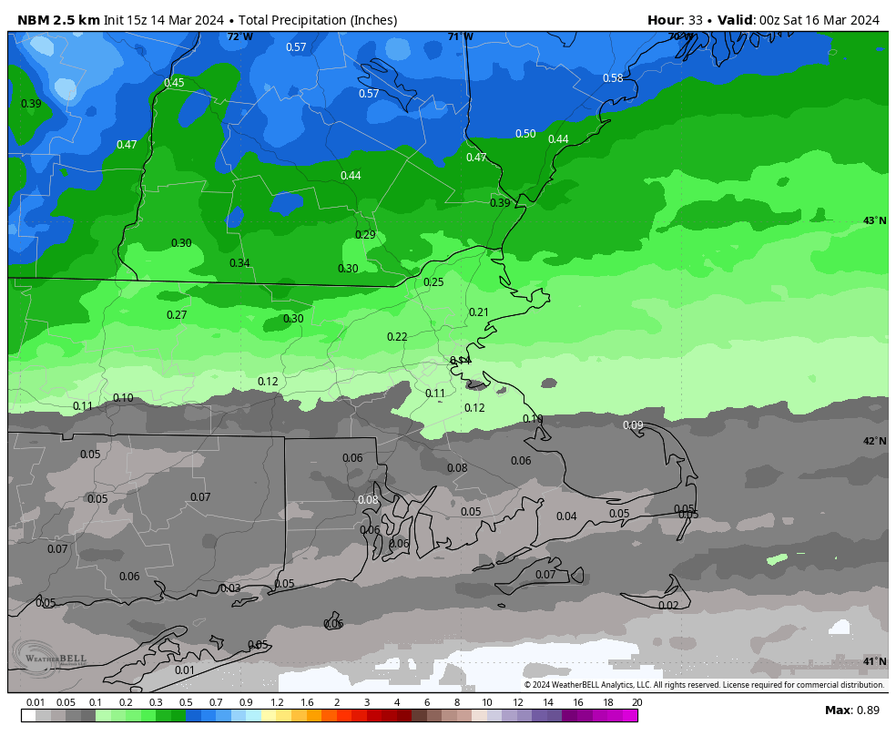
Most of the rain tonight and Friday will be light, especially south of the Mass Pike. Image provided by WeatherBell.

We hope you enjoyed the nice weather today, because changes are coming quickly. Clouds quickly move in this evening ahead of a cold front, with some showers likely overnight and into Friday morning. The rain should end before midday as a wave of low pressure riding along the front moves offshore, but northeast winds off the still-chilly Atlantic will keep plenty of clouds around, with some drizzle and another shower or two possible, especially in eastern portions of the region. Temperatures will also be about 15-20 degrees cooler than today, likely staying in the 40s and lower 50s, especially north of the Mass Pike, but south of there, the warmer air may hang around especially during the morning if the cold front moves though a little slower. We’ll see a little clearing for Saturday as high pressure tries to build in, which will allow temperatures to moderate a little, but another front quickly follows for Sunday, with another round of showers, mainly during the morning hours. Some gusty winds are possible again behind the front later Sunday. By Monday, high pressure will try to start building in, but we’ll still be dealing with low pressure moving into Atlantic Canada. The result will be more clouds (with some sunshine), along with breezy and chilly conditions. In other words, typical mid-March weather.

Friday could end up quite mild across southern parts of the area. Images provided by Pivotal Weather.

Thursday night: Becoming mostly cloudy with showers developing, patchy fog possible, especially across Cape Cod. Low 37-44.

Friday: Showers end in the morning, plenty of clouds for the afternoon with some drizzle, maybe another shower or two. High 52-59 south of the Mass Pike, 44-51 north of the Pike.

Friday night: Partly to mostly cloudy. Low 32-39.

Saturday: Partly sunny. High 48-55, a little cooler across Cape Cod.

Saturday night: Clouds return, becoming breezy, showers possible late at night. Low 35-42.

Sunday: Morning showers, some afternoon sun may develop, windy. High 48-55.

Sunday night: Clear to partly cloudy. Low 29-36.

Monday: Intervals of clouds and sun, breezy. High 41-48.

Weekly Outlook: March 11-17, 2024

After a couple of heavy rainstorms, some drier and milder air is on the way this week.

It’ll be quite windy across the region today. Images provided by WeatherBell.

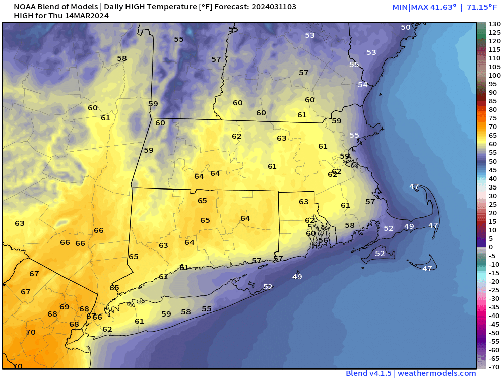
The storm system that brought in the rain yesterday morning will move into Atlantic Canada today while high pressure starts to build in from the west. With a tight pressure gradient between the two, it’ll be quite the windy day, with sustained winds of 20-30 mph and gusts to 40-50 mph or higher across the region. Clouds will gradually give way to some sunshine today, but temperatures will remain on the cool side. The high pressure area then builds for Tuesday into Thursday. Sunshine will return on Tuesday with diminishing winds. A few clouds are expected on Wednesday, but temperatures will start to moderate as a warm front moves through, possibly accompanied by a shower or two. Clouds will become a little more numerous on Thursday, but temperatures could get well into the 60s across the area, away from the shoreline, where a seabreeze is expected. More showers are possible though ahead of a cold front.

Right now, Thursday is looking like a very mild day. Image provided by Weathermodels.com

The end of the week and the weekend is a different story. A series of weak systems will move through, with episodes of showers likely. It’s not going to rain the entire time, and the rain shouldn’t be that heavy, but it won’t be the nicest of weekends. Temperatures will cool off, but still remain above normal for mid-March. Friday is the day that is the biggest question mark. Some models have the cooler air move in rather early, some wait until later in the day. If the earlier ones are right, temperatures may only be in the 40s or lower 50s for highs, but if the later ones are right, we could get well into the 60s once again. We’re leaning towards the cooler model solutions at this time, but we will refine this forecast when we publish our Weekend Outlook on Thursday.

Will Friday be warm, mild, or cool? Depends on which model you trust. Images provided by Pivotal Weather.

Monday: Morning clouds give way to some afternoon sunshine, windy. High 38-45.

Monday night: Clear skies, breezy. Low 28-35.

Tuesday: Plenty of sunshine, still breezy, not as cool. High 48-55.

Tuesday night: Clear skies during the evening, some clouds start to filter in late at night. Low 29-36.

Wednesday: A mix of sun and clouds, just a slight chance for a shower. High 52-59, cooler along the coast.

Thursday: Partly sunny and mild, showers possible late in the day and into the evening. High 57-64, cooler along the coast.

Friday: Mostly cloudy and breezy with showers likely. High 48-55.

Saturday: Intervals of clouds and sunshine, breezy, chance for a few showers, mainly early. High 47-54.

Sunday: Partly to mostly cloudy, breezy, rain possible. High 48-55.

Weekend Outlook: March 8-11, 2024

If you liked all the rain last night and this morning then you’re in luck, as there’s more on the way for part of the weekend!

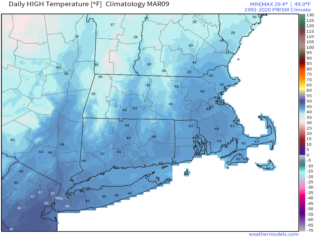
Average high temperatures for early March are in the lower to middle 40s. Image provided by Weathermodels.com

Clouds hang around this evening, then we’ll start to clear out late tonight as high pressure builds in. Friday should be a rather nice early March day with sunshine and mild temperatures, though we may see some clouds hang around across Cape Cod and possibly southeastern Massachusetts. Clouds stream back in Friday night and Saturday as another low pressure system heads our way. This system should pass north and west of the region, so we’ll be on the warm side of it, with mostly rain expected. Could there be a little wet snow mixed in at the start? It’s possible, mainly across the hills of Worcester County and up into the Monadnocks, but don’t count on it. Rain will end Sunday morning, but it will remain cloudy for much of Sunday, with windy and colder weather moving in. An upper-level disturbance moves through Sunday evening, and it could produce a few rain or snow showers. Skies will start to clear out on Monday as high pressure starts to build back in.

Much of the region could pick up another inch of rain Saturday night. Images provided by WeatherBell.

Thursday night: Plenty of clouds through the evening, some clearing late at night, still breezy. Low 30-37.

Friday: Sunshine and a few clouds. High 44-51, coolest along the coast.

Friday night: Increasing clouds. Low 28-35.

Saturday: Plenty of clouds, becoming breezy. High 39-46.

Saturday night: Windy with rain likely, some of it could be heavy. Low 33-40 during the evening, temperatures rise overnight.

Sunday: Rain ends in the morning, clouds with a few sunny breaks possible in the afternoon, windy. High 49-56.

Sunday night: Mostly cloudy and breezy with some rain or snow showers possible during the evening. Low 27-34.

Monday: A mix of sun and clouds, breezy. High 40-47.

Weekly Outlook: March 4-10, 2024

An active weather pattern means you won’t see the sun much this week.

Highs near or over 60 on Wednesday? It’s possible. Image provided by Weathermodels.com

High pressure is in control to start the week, but with plenty of low-level moisture around we’ll have plenty of clouds, along with some spotty drizzle. If we can get any sunshine, especially well inland, temperatures could get well into the 50s again, otherwise, places closer to the coast will stay in the 40s. A weak low pressure area moves up the coast for Tuesday, spreading some showers in, and keeping temperatures in the 40s, but that is still above normal for early March. We’ll turn much milder on Wednesday, with some spots possibly topping 60 degrees, despite plenty of clouds once again as another system begins to head toward the region. This one will bring in more rain for late Wednesday into Thursday, and some of it could be heavy. We’ll turn cooler on Thursday as system moves through, and there’s a chance that the rain could mix with snow before ending Thursday evening, especially north and west of Boston. Friday looks to be the pick of the week with some sunshine developing as high pressure builds in briefly.

The potential exists for some very heavy rain with the storm Wednesday into Thursday. Image provided by WeatherBell.

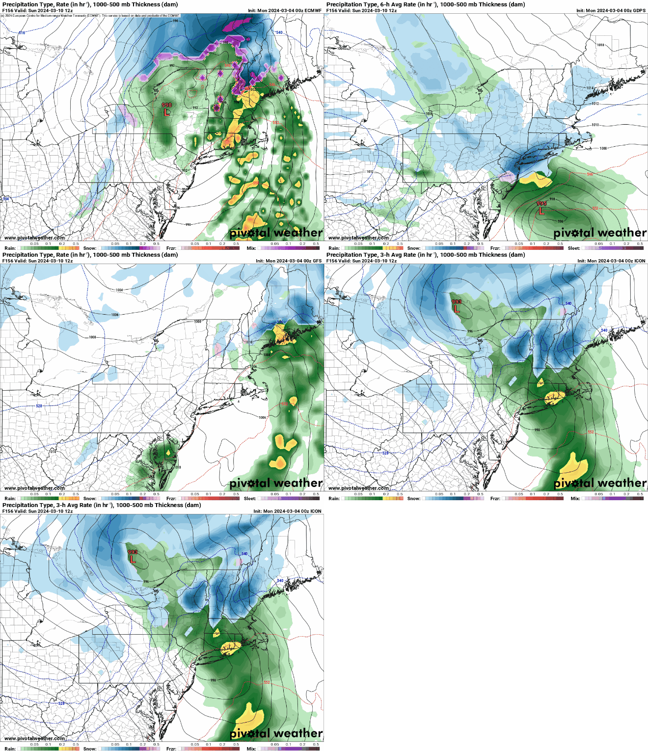
Next weekend is a bit uncertain at this point. Most of the models show a system impacting the region, but they don’t agree on the timing or the details of the system. Temperatures look to be colder, and there is a chance that we could see some snow from the system across parts of the region. It is still early March, so this is not an uncommon occurrence. We should have a better idea of what to expect and when to expect it by the time we get to our Weekend Outlook Thursday afternoon.

The models all have a storm impact the region next weekend, but the timing and details vary quite a bit. Images provided by Pivotal Weather.

Also, don’t forget – Daylight Saving Time begins next Sunday at 2am, when we “Spring Ahead”, and you lose an hour of sleep. The good news? Sunset next Sunday is at 6:45pm.

Monday: Patchy morning fog, otherwise plenty of clouds with some spotty drizzle, a few sunny breaks possible, especially inland. High 47-54, coolest along the coast.

Monday night: Cloudy with a chance for a few late-night showers. Low 36-43.

Tuesday: Plenty of clouds with showers likely, especially in the afternoon. High 45-52.

Tuesday night: Overcast with showers ending in the evening. Low 38-45 during the evening, temperatures hold steady or rise a bit overnight.

Wednesday: Cloudy and milder with rain developing in the afternoon, possibly heavy at night. High 55-62, cooler across the South Coast and Cape Cod.

Thursday: Windy with showers gradually ending. High 42-49.

Friday: A mix of sun and clouds, breezy. High 42-49.

Saturday: Cloudy and breezy with some rain or snow possible. High 39-46.

Sunday: Cloudy and breezy with a chance for rain or snow. High 43-50.

Weekend Outlook: March 1-4, 2024

March won’t be coming in like a lion, but it will be coming in milder.

A weak storm system (definitely not a lion) will bring some rain to the area this weekend. Loop provided by Tropical Tidbits.

We’re starting the weekend with high pressure in control, which will help to produce a chilly night tonight under clear skies and lighter winds. As the high moves off to the east, winds will become southwesterly on Friday, allowing milder air to move in under sunny skies. Make sure you enjoy it, because Friday is the pick of the weekend. A weak low pressure system will move off the Mid-Atlantic coast Friday night, slowly passing south of New England on Saturday. This will result in plenty of clouds and some showers, especially during the afternoon and at night, but temperatures should remain above normal for early March. The system pulls away on Sunday, but clouds will linger, and a few showers are still possible, mainly across eastern portions of the region and during the morning. High pressure starts to build in for Monday, but we’ll still have plenty of clouds around with another weak low pressure area meandering around to the south. It should stay far enough south to not send any precipitation our way, but we’ll keep an eye on that. Temperatures will remain mild. In fact, even milder weather appears likely for the first half of next week.

Much of next week should feature well above normal temperatures. Image provided by WeatherBell.

Thursday night: Skies become partly cloudy to clear with diminishing winds. Low 19-26.

Friday: Plenty of sunshine, a little breezy during the afternoon. High 38-45.

Friday night: Clear during the evening, then clouds increase. Low 28-35 during the temperatures, temperatures hold steady or rise a little overnight.

Saturday: Cloudy and milder with some showers likely during the afternoon. High 44-51.

Saturday night: Cloudy, showers taper off late at night. Low 38-45.

Sunday: Plenty of clouds, a few morning showers in eastern areas, maybe a few breaks of sunshine in the afternoon. High 48-55.

Sunday night: Partly to mostly cloudy. Low 38-45.

Monday: More clouds than sun. High 47-54.

Weekly Outlook: February 26 – March 3, 2024

Some interesting weather is on the way for the upcoming week.

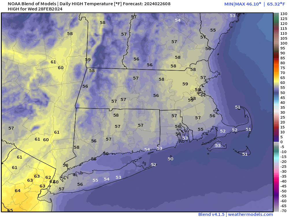
Temperatures could approach 60 in parts of the region on Wednesday. Image provided by Weathermodels.com

A warm front will move across the region this morning with a few rain or snow showers accompanying it. We’ll clear out this afternoon with milder weather settling in. High pressure builds in for Tuesday with partial sunshine and even milder weather but clouds will thicken up by evening as a strong cold front begins to approach from the west. Gusty south to southwest winds ahead of the front will send temperatures well into the 50s on Wednesday, despite plenty of clouds and some occasional rain showers. The front moves through late in the day, then colder air surges in quickly behind the front. Rain may change to snow before coming to an end Wednesday night as temperatures quickly drop on gusty northwest winds.

Southwest winds could gust as high as 40-50 mph or higher on Wednesday. Image provided by WeatherBell.

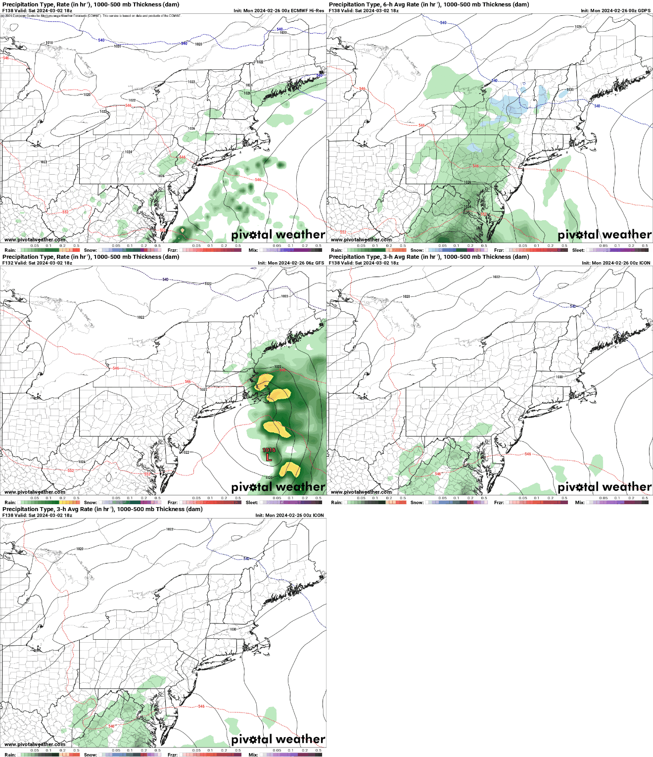
High pressure returns with chilly weather on Thursday, but the cold air won’t hang around too long. Temperatures start to moderate on Friday as the high moves off to the east, then unseasonably warm weather returns for the first weekend of March. However, we’ll also have to keep an eye on a low pressure area off to the south, as it may spread more clouds and possibly some rainfall in, especially near the South Coast on Saturday.

Saturday could end up being wet, or maybe it won’t. We’ll have a better idea later this week. Images provided by Pivotal Weather.

Monday: A rain or snow shower early, becoming partly to mostly sunny and breezy during the afternoon. High 46-53, coolest across the South Coast.

Monday night: Partly cloudy. Low 27-34.

Tuesday: Some morning sun, clouds thicken up in the afternoon, winds start to pick up late in the day. High 50-57, coolest near the coast.

Tuesday night: Cloudy and windy with showers developing. Low 42-49 during the evening, temperatures rise a little overnight.

Wednesday: Cloudy and windy with periods of rain and showers, possibly even a rumble of thunder. Rain may change to snow before ending at night. High 51-58, coolest across the South Coast.

Thursday: Becoming mostly sunny, windy, and much colder. High 32-39.

Friday: Sunshine and some afternoon clouds, still breezy. High 39-46.

Saturday: More clouds than sun, chance for some showers, breezy. High 46-53.

Sunday: Partly sunny. High 51-58.

Weekend Outlook: February 23-26, 2024

The final weekend of February and Meteorological Winter will feature a little bit of everything.

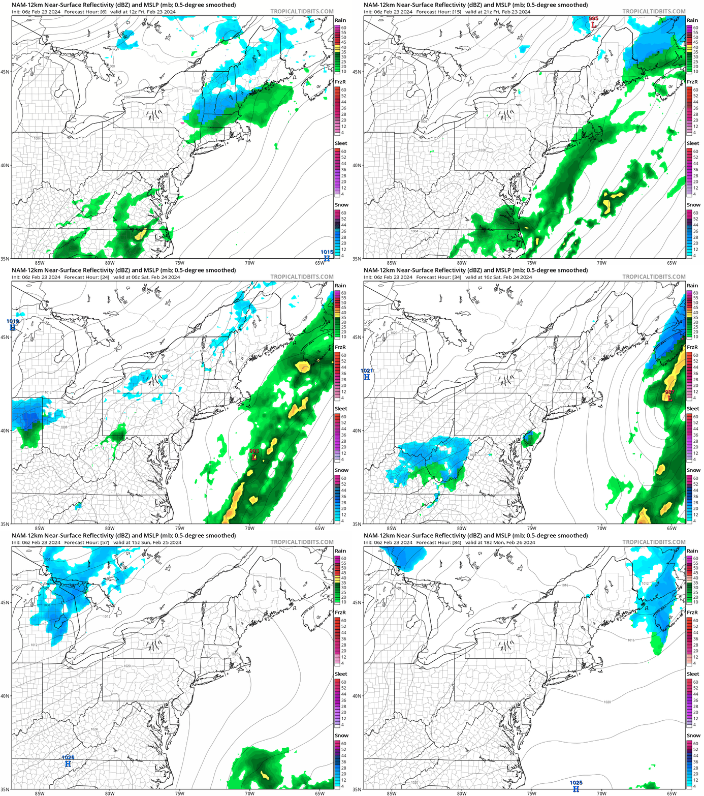
One system brings in some rain today, another has some light snow or rain Sunday night. Loop provided by Tropical Tidbits.

Some showers are likely through the morning ahead of a cold front, with some wet snow at least to start as you get up into the hills of south-central New Hampshire. The cold front moves through by midday, but a wave of low pressure will ride up along it as it moves offshore. This may keep the rain going for several more hours across Cape Cod, while the rest of us start to dry out. Gusty northwest winds behind the system usher much cooler air in for tonight and Saturday as high pressure builds in with sunshine. Winds die down Saturday night and skies remain clear, setting the stage for a rather chilly night. The cold air doesn’t last long though as temperatures start to moderate a bit on Sunday, getting back closer to normal for late-February. Another weak system moves through Sunday night with some snow or rain showers, then milder air moves in for Monday.

Bundle up if you’re heading outside early Sunday morning – wind chills will be in the single numbers. Image provided by WeatherBell.

Friday: Cloudy with showers likely through early afternoon north and west of Boston, ending in the evening south of Boston. High 41-48.

Friday night: Mostly cloudy, a few lingering showers across Cape Cod through midnight, some clearing possible toward daybreak. Low 25-32.

Saturday: Becoming mostly sunny, breezy, and colder. High 31-38 in the morning, temperatures may start to drop after midday.

Saturday night: Clear and chilly. Low 11-18.

Sunday: Sunshine and some afternoon clouds, becoming breezy late in the day. High 33-40.

Sunday night: Mostly cloudy and breezy with some snow or rain showers likely. Low 23-30 during the evening, temperatures start rising after midnight.

Monday: Morning clouds, then becoming partly sunny, breezy, milder. High 44-51.

Weekly Outlook: February 19-25, 2024

Much of the upcoming week will feature quiet weather with a gradual warming trend.

Normal high temperatures are in the upper 30s to lower 40s across the region. Image provided by Weathermodels.com

High pressure builds in for today and Tuesday with sunshine and cool temperatures. As the high slides off to the east on Wednesday, temperatures will start to moderate as winds become southwest, but we’ll also see a few clouds start to filter in. More clouds and warmer temperatures are likely on Thursday as a cold front begins to approach from the west. A cold front moves in on Friday with a wave of low pressure developing along it and passing close to or south of the region. This will keep temperature cooler, but still warm enough so that precipitation should be mostly in the form of rain, but it could start as some wet snow north and west of Boston late Thursday night or early Friday. High pressure returns with much cooler conditions on Saturday. Another low pressure system may bring in some rain or snow showers later Sunday and Sunday night.

We could see a little snow or mix as precipitation moves in before daybreak on Friday. Images provided by Pivotal Weather.

Monday: Sun, sun, and more sun, breezy, and cool. High 32-39.

Monday night: Clear skies, chilly. Low 14-21.

Tuesday: Plenty of sunshine. High 29-36.

Tuesday night: Clear to partly cloudy. Low 17-24.

Wednesday: A mix of sun and clouds. High 34-41.

Thursday: Partly sunny, clouds thicken up late in the day. High 38-45.

Friday: Cloudy and breezy with some rain likely, possibly starting as snow or a wintry mix north and west of Boston. High 41-48.

Saturday: A mix of sun and clouds, breezy, cooler. High 31-38.

Sunday: Partly sunny, some rain or snow showers possible toward evening, breezy. High 34-41.

Weekend Outlook: February 16-19, 2024

We’ve got a few chances for snow over the next several days, but most of them be minor.

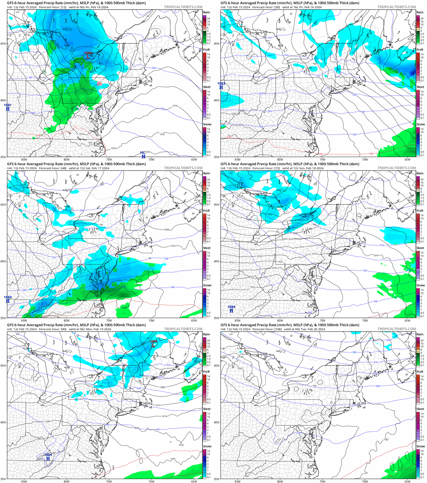
A few systems will move across the Northeast this weekend, but most won’t have too much of an impact. Loop provided by Tropical Tidbits.

A fast-moving system will move out of the Great Lakes later today, passing north of the region tonight. It will produce some light snow this evening, so use some caution if you’re heading out. The snow should end shortly after midnight, with less than 1 inch of accumulation south of the Mass Pike, and 1-2 inches north of it, possibly near 3 inches in a few spots. We’ll quickly clear out on Friday with high pressure building in, but we’ll have gusty northwest winds once again, resulting in a rather cool day. Clouds quickly return late Friday and Friday night as a weak low pressure system moves toward the Mid-Atlantic states. It will pass well south of the region on Saturday, with just some snow showers, mainly south of the Mass Pike. There could be some steadier snow near the immediate South Coast and across the Islands, but even here, we’re only expecting an inch or so, maybe 2 inches in a few spots. Another weak disturbance moves through on Sunday with some clouds and possibly a snow flurry or two, then high pressure builds in with sunshine for Monday.

Tonight’s snowfall will be relatively light across most of the area. Image provided by WeatherBell.

Thursday night: Light snow likely, ending shortly after midnight, some clearing late at night. Accumulation 1-2 inches north of the Mass Pike, 1 inch or less south of the Pike, breezy. Low 24-31.

Friday: Partly to mostly sunny and windy, clouds start to move back in late in the day. High 33-40.

Friday night: Becoming mostly cloudy. Low 20-27.

Saturday: Mostly cloudy with some snow showers, mainly south of the Mass Pike. High 30-37.

Saturday night: Clearing. Low 14-21.

Sunday: Intervals of clouds and sun, breezy, chance for a snow flurry. High 31-38.

Sunday night: Clear skies, breezy. Low 21-28.

Monday: Plenty of sunshine, still breezy. High 33-40.

Snowy Tuesday on the Way for Most

Tuesday is looking like a snowy day, but perhaps not as bad as we were thinking earlier, for at least part of the region.

Winter Storm Warnings remain in effect across much of the region. Image provided by Pivotal Weather.

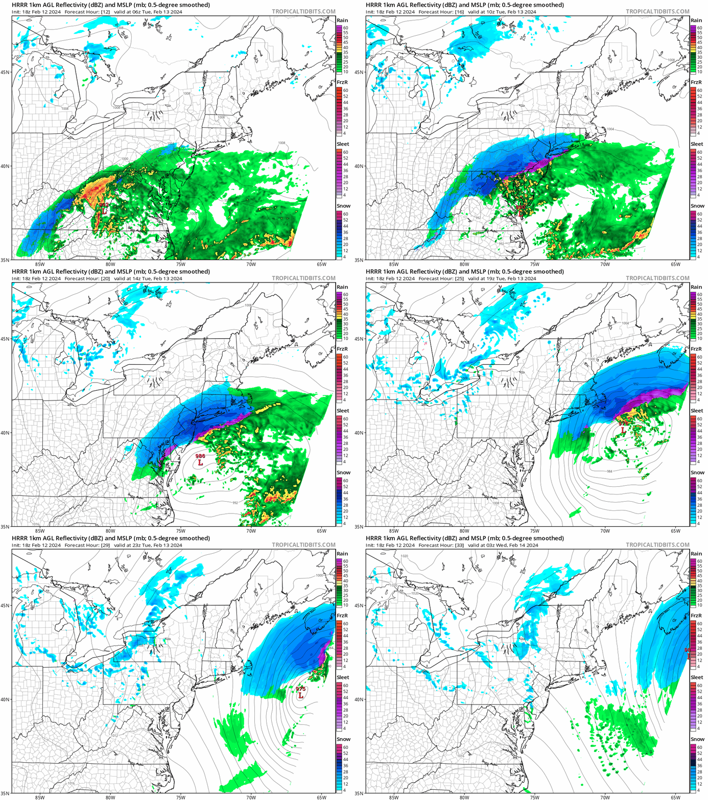
The general ideas we talked about in our Weekly Outlook earlier today are still valid. Low pressure is moving across the Tennessee Valley this afternoon and will redevelop near the Mid-Atlantic coastline later today, passing south of New England on Tuesday as it intensifies. However, some of the finer details have changed a bit. For one, the timing of the snow has been altered slightly. The snow should develop across the region near or a little before daybreak, and it may fall heavy at times for a while during the late morning and early afternoon, but now it looks like it will be winding down by late-afternoon, ending completely around the evening rush hour. This is a little faster than we were thinking earlier.

The snow should be in an out of here in roughly 8-10 hours. Loop provided by Tropical Tidbits.

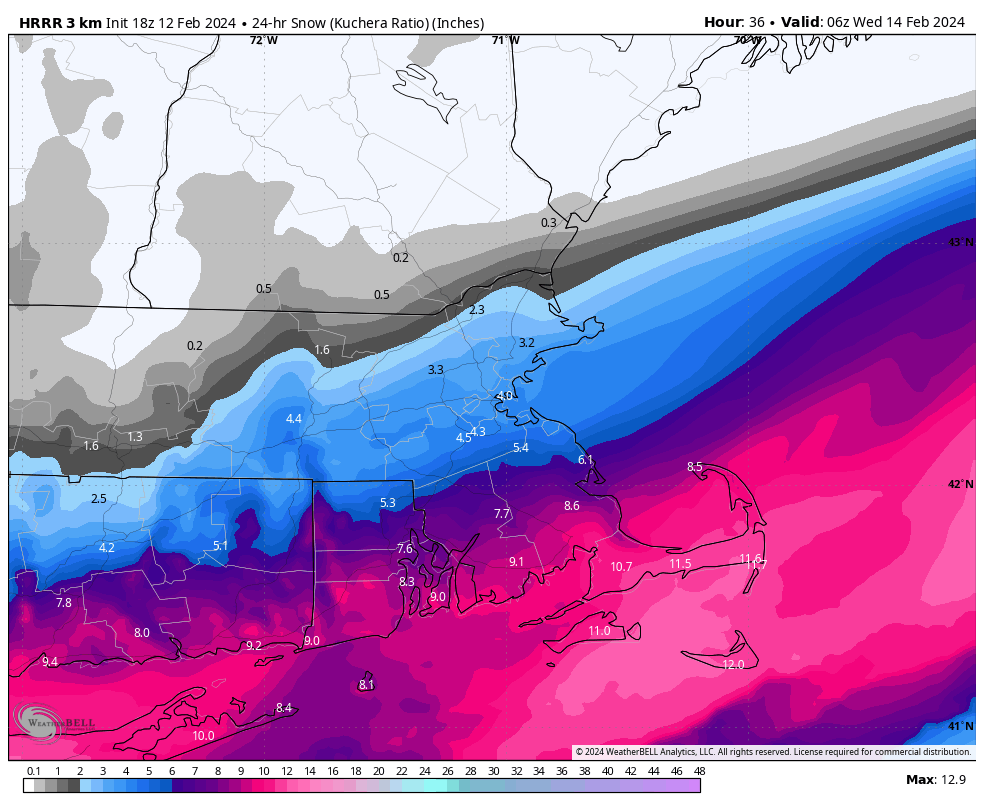
It also looks like the storm will be a little farther south than we were thinking. This has significant implications for the snowfall forecast. This shifts the area of heaviest snow a little farther south. The bigger change is on the northern fringe of the snowfall. We had talked about the fact that the models were showing a sharp cutoff to the snow, and you could go from little to nothing to well over 6 inches in the span of 20 miles. That is still the case, but instead of that being over central or southern New Hampshire as we thought overnight, it’s now looking like that could be across southern New Hampshire or the Merrimack Valley. So, how much are we expecting now?

Central/Southern NH: 1″ or less
Merrimack Valley: 1-4″
MetroWest/Metro Boston/North Shore: 3-6″
Southeastern Massachusetts/Rhode Island: 4-8″
Cape Cod and the Islands: 6-10″ (possibly less Outer Cape/Islands with some rain to start)

The latest run of the HRRR model is closest to our thinking now. Image provided by WeatherBell.

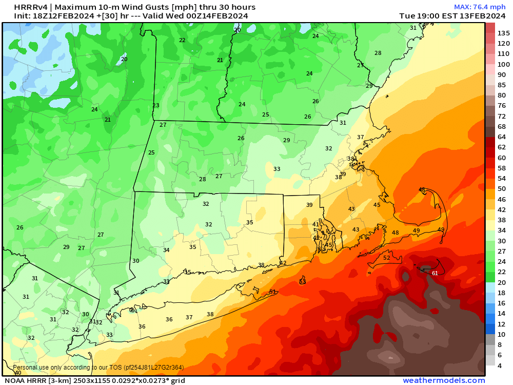
The other aspects of the storm that we mentioned – strong winds and coastal flooding, have not changed. A High Wind Warning is in effect across Cape Cod, where sustained winds of 20-30 mph are expected, with gusts to 50 mph possible. The rest of the region is looking at gusts of 25-35 mph, with some stronger gusts, especially near the coast. Along the coast, flooding is possible around high tide, especially in the areas that are normally prone to flooding.

Gusty winds are still likely on Tuesday, especially at the coastline. Image provided by Weathermodels.com

We’re also still keeping an eye on the potential for more light snow Thursday night and again on Saturday with two additional storm systems. More on that later in the week.