Much of the upcoming weekend will be dry with temperatures fairly close to where we should be in the first half of April.
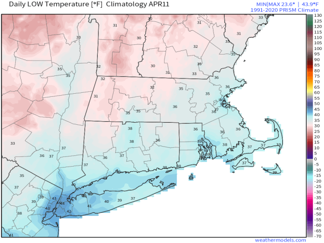
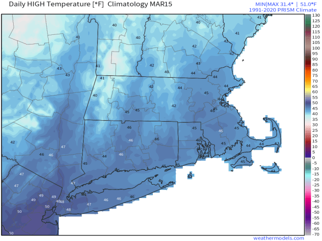
Average low temperatures are still in the 30s at this time of year. Image provided by Weathermodels.com
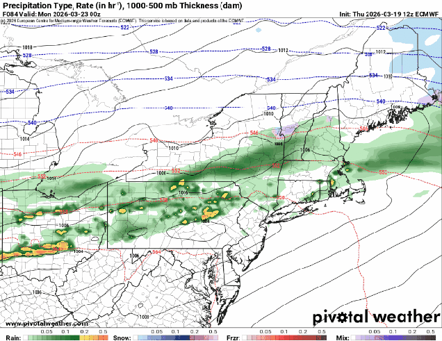
High pressure slides offshore with southwest winds bringing milder air into the region for tonight and Friday, except along the South Coast, where southwest winds are a seabreeze off the still-chilly Atlantic. Clouds will start to move in later Friday ahead of a cold front. That front may produce a few showers Friday night, but it will bring cooler air in for Saturday as high pressure builds in behind it. That high moves eastward on Sunday, with a chilly start to the day, but as winds shift back into the southwest, we’ll see milder air start to move back in by late in the day. Low pressure heading into southeastern Canada will drag a warm front across the region Sunday night, possibly accompanied by a few showers, setting up a very mild day on Monday.
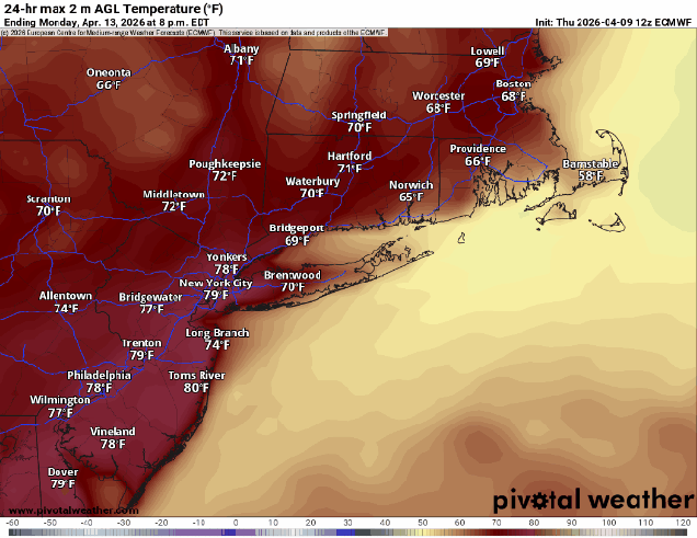
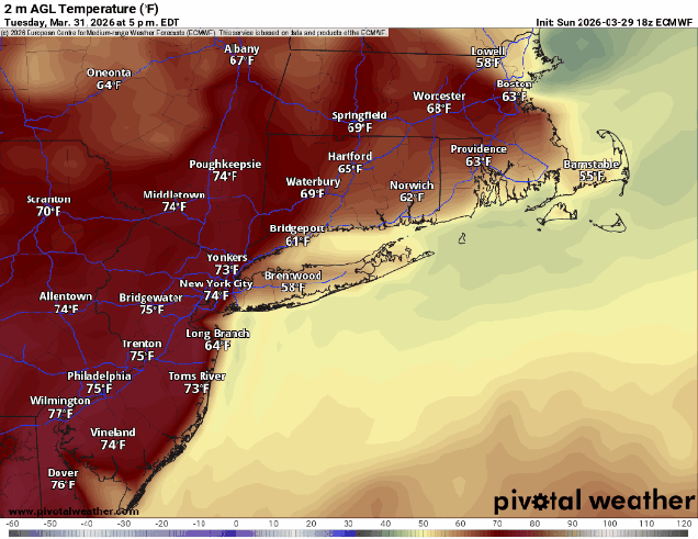
How warm will it get Monday? Images provided by Pivotal Weather.
Thursday night: Partly cloudy. Low 31-38.
Friday: Sunshine gives way to increasing afternoon clouds, breezy. High 62-69, cooler across Cape Cod and the South Coast.
Friday night: Mostly cloudy, chance for a few showers, skies start to clear out late at night. Low 40-47.
Saturday: Plenty of sunshine, breezy. High 53-60.
Saturday night: Clear skies. Low 31-38.
Sunday: Partly sunny. High 51-58.
Sunday night: Mostly cloudy, chance for a few showers. Low 39-46.
Monday: More clouds than sunshine, breezy, milder. High 64-71, cooler across Cape Cod and the South Coast.
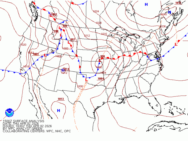
A frontal system will be hanging around through the weekend, with its exact location determining our weather each day.
A wavy frontal system separates chilly air to the north from very mild air to the south across the eastern half of the nation. Image provided by the Weather Prediction Center.
That front is well to our south this afternoon, with some rather chilly air in place, while weak disturbances will bring in some showers this afternoon and tonight. As a low pressure system moves into the Great Lakes and then southeastern Canada tonight and Friday it will drag that front back northward, resulting in a return of milder air, with some sunshine possible Friday afternoon. This should result in some rather nice weather for the Red Sox home opener, though the day may start gloomy and cool. However, our warm weather will be short-lived, as the front drops back southward on Saturday, bringing the cooler air back, though we’ll likely remain on the dry side. Another low pressure system heads into the Great Lakes for Easter Sunday, bringing the front northward once again, so the rollercoaster ride will continue, with temperatures turning milder once again. That system brings in some rain for Sunday and Sunday night before it drags the cold front through, with, you guessed it, colder air returning on Monday.
The home opener at Fenway means summer isn’t far away.
Thursday night: Plenty of clouds with some drizzle and fog as well as some widely scattered showers, mostly after midnight. Low 30-37.
Friday: Morning clouds, maybe a lingering shower, becoming partly sunny and breezy in the afternoon. High 58-65, cooler across the South Coast and Cape Cod.
Friday night: Variably cloudy. Low 46-53.
Saturday: Partly sunny with increasing and thickening afternoon clouds, breezy. High 56-63 in the morning, temperatures drop through the daytime.
Saturday night: Mostly cloudy. Low 35-42.
Sunday: Cloudy and breezy with showers likely. High 58-65, cooler across the South Coast and Cape Cod.
Sunday night: Showers end in the evening, gradual clearing overnight. Low 33-40.
Monday: A mix of sun and clouds, breezy. High 46-53.
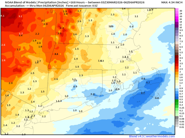
Temperatures will be quite mild for half the week, and quite chilly for half the week. In between, some much needed rain is on the way.
Parts of the region could see an inch or so of rainfall this week. Image provided by Weathermodels.com
The week starts off with high pressure moving off the East Coast, with southwest winds around the high bringing milder weather in, though the South Coast and Cape Cod will remain cooler as a southwest wind is a seabreeze off the still-chilly Atlantic. Tuesday could be a bit trickier. A backdoor cold front will be dropping southward, bringing some showers into the region. How far south the front gets before stalling out will have a big impact on the temperature forecast. South of the front, temperatures will likely get into 60s (cooler near the South Coast), while north of the front, temperatures will only be in the 40s. This boundary will lift back northward at night.
Temperatures Tuesday afternoon will be highly dependent on the location of a backdoor cold front.
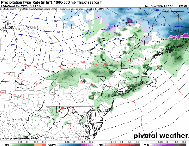
Wednesday will likely be a mild day across the region, but low pressure crossing northern New England will drag a cold front through, with another round of showers and possibly some thunderstorms ahead of the front during the afternoon. Much cooler air settles in behind the front for Wednesday night and Thursday, but the front will stall out to our south and a wave of low pressure will ride along it, bringing in some additional rainfall. Friday has the potential to be another tricky day, and it’s also the Red Sox home opener, so a lot of people will be paying attention to this forecast. Another wave of low pressure will ride along the front late Friday and Friday night, with some more showers, but for now, it looks like much of the day will stay dry. The question is in the temperature forecast. Some models have the wave passing farther north, bringing the front back through as a warm front, some keep it farther south, with chilly weather remaining in place. Some additional showers possible on Saturday, then Sunday looks similar to Friday, with another system possibly dragging the front northward, allowing warmer air to briefly return before showers and another cold front move in.
Opening Day looks cloudy, and potentially mild, but dry, for now at least. Image provided by Major League Baseball.
Monday: Intervals of clouds and sun, breezy. High 60-67, cooler near the South Coast and Cape Cod.
Monday night: Partly to mostly cloudy, chance for some late-night showers. Low 43-50.
Tuesday: More clouds than sun with some showers likely, especially in the morning. High 58-65, cooler near the South Coast and Cape Cod, temperatures may drop during the afternoon, especially along the coast and into parts of northeastern Massachusetts and southern New Hampshire..
Tuesday night: Partly to mostly cloudy, breezy, chance for a shower or two. Low 42-49, temperatures start to rise after midnight.
Wednesday: Plenty of clouds with a few sunny breaks early, breezy, showers developing in the afternoon, possibly a thunderstorm. High 67-74, cooler near the South Coast and Cape Cod.
Wednesday night: Mostly cloudy with more showers, mainly during the evening. Low 34-41.
Thursday: Lots of clouds, chance for a few showers, much cooler. High 39-46.
Thursday night: Cloudy with some showers possible. Low 31-38.
Friday: Mostly cloudy. High 51-58.
Saturday: Mostly cloudy, chance for a few showers. High 50-57.
Sunday: Cloudy with a chance for more showers. High 57-64.
The final weekend of March will be mostly dry, but on the chilly side.
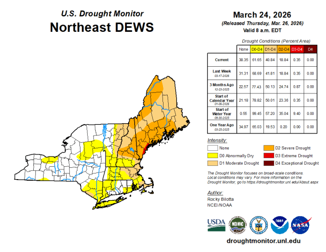
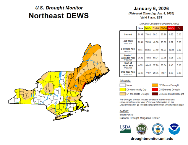
Drought conditions remain in place for much of the Northeast. Image provided by the National Drought Mitigation Center.
A cold front will drop southward across the region tonight, bringing some rain into the region, which is good, since we need as much as we can get with the drought ongoing. The rain will end Friday morning as the front settles offshore, then gusty northwest winds will usher much cooler air back in. Saturday will be a rather chilly day with an upper-level disturbance generating some afternoon clouds and possibly a few rain or snow showers. Temperatures will only be in the 30s, and wind chills will likely be in the 20s. High pressure then slides offshore for Sunday with sunshine and moderating temperatures, though still a little below normal for late March. We’ll continue the warmup with dry weather on Monday.
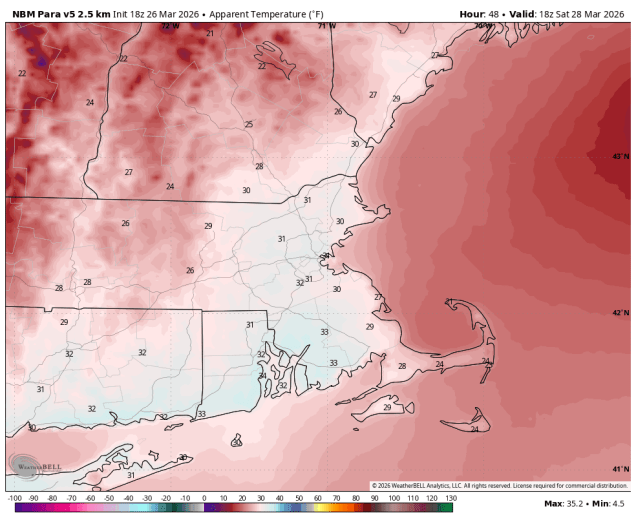
Wind chills will be in the 20s and lower 30s Saturday afternoon. Image provided by WeatherBell.
Thursday night: Cloudy with rain likely, tapering off late at night. Low 36-43.
Friday: Any lingering showers end in the morning, becoming partly to mostly sunny and breezy in the afternoon. High 43-50.
Friday night: Clear during the evening, partly cloudy overnight. Low 21-28.
Saturday: Partly sunny, breezy, chance for a few afternoon rain or snow showers. High 32-39.
Saturday night: Becoming clear. Low 21-28.
Sunday: Sunshine and some afternoon clouds, breezy. High 42-49.
Sunday night: Partly to mostly cloudy. Low 31-38.
Monday: Intervals of clouds and sun, breezy. High 54-61, a little cooler across Cape Cod and the South Coast.
Spring officially begins at 10:46am on Friday, but that doesn’t really mean that we’re done with winter weather.
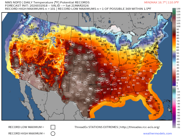
Record highs and summerlike temperatures are likely this weekend across a majority of the nation…..except the Northeast and Great Lakes. Image provided by weathermodels.com
While the rest of the nation gets an early taste of summer for the next few days, here in New England, we’re reminded that Spring is usually delayed compared to everywhere else. A weak system will pass north of the region tonight generating some clouds and possibly a few flurries, favoring areas north of Route 2. We’ll clear out late at night, but clouds will quickly move back in Friday afternoon as another low pressure system heads our way. We’ll see some rain moving in by evening, ending around daybreak Saturday. We’re not expecting heavy rain from this, but every little bit helps put a dent in the ongoing drought. While we should see some sunny breaks developing Saturday afternoon, plenty of clouds will hang around as yet another system heads our way. This system could be a little trickier. Some models show a mild day with temperatures topping 60 before some rain moves in during the afternoon ahead of a cold front. Other say that it might be cold enough to start as some snow across parts of southern New Hampshire or even the Merrimack Valley, changing to rain, then back to snow or sleet behind the cold front from the Mass Pike northward before everything winds down early Monday. We’re going to lean towards the milder scenario for now, but with low confidence. Gradual clearing is expected during the day Monday as the cold front pushes offshore.
The models all have different ideas for what to expect Sunday evening. Images provided by Pivotal Weather.
Thursday night: Partly cloudy, slight chance for a flurry north of Route 2. Low 27-34.
Friday: Morning sun, then clouds stream back in, rain developing late in the day, becoming breezy. High 47-54.
Friday night: Periods of rain and showers, ending before daybreak. Low 35-42.
Saturday: Intervals of clouds and sunshine. High 47-54.
Saturday night: Partly to mostly cloudy. Low 31-38.
Sunday: Plenty of clouds with showers developing in the afternoon. High 47-54.
Sunday night: Rain may change to snow and/or sleet before ending overnight, especially north of the Mass Pike. Low 30-37.
The week is going to start off with a potent storm system heading our way.
A couple of batches of rain are likely today and tonight, maybe even some thunderstorms. Loop provided by Weathermodels.com
The low pressure system bringing blizzard conditions to the Great Lakes will impact us over the next 36 hours, but not with blizzard conditions. A warm front extending eastward from the system will cross the region today, with some rain ahead of it through the morning hours. Once the front moves through, gusty southerly winds will bring milder air back in, but the rain will taper off to some widely scattered showers. However, steadier and heavier rain will return by evening as a cold front begins to approach from the west. A line of thunderstorms may accompany the front tonight, though any severe weather will likely be well to our south. Rain ends by daybreak Tuesday as the front pushes offshore, with gusty west winds behind the front bringing much colder air back in. While we’ll start to clear out in the morning, a secondary cold front will bring some clouds back in during the afternoon, with a few stray flurries possible.
Temperatures will get into the 60s across much of the region Monday evening ahead of the cold front. Image provided by WeatherBell.
High pressure builds in with dry and chilly conditions for Wednesday, but as it slides off to the east, temperatures will start to moderate for Thursday and Friday. Another system may move in for the weekend, but there is a lot of uncertainty with this storm, with some rain or snow possible, depending on the eventual evolution of the system. We should have more clarity by the time we get to our Weekend Outlook on Thursday.
The models all have different ideas about a potential storm next weekend. Images provided by Pivotal Weather.
Monday: Cloudy and becoming windy with rain during the morning, tapering off to occasional showers during the afternoon. High 55-62.
Monday night: Windy with rain redeveloping, possibly heavy at times, some thunderstorms are possible. Rain ends before daybreak. Low 34-41.
Tuesday: Becoming partly sunny, breezy, chance for a few late-day flurries. Temperatures hold steady or drop during the daytime.
After an early taste of Spring this week, Mother Nature is going to remind us that it’s still March, and astronomical Spring doesn’t start for another week.
Average high temperatures for mid-March are in the middle 40s. Image provided by weathermodels.com
A wave of low pressure will ride along the cold front that crossed the region earlier today, bringing in some additional precipitation this evening. We’ll see rain changing over to sleet and then snow during the late afternoon and evening, ending before midnight. Some places could see a coating to perhaps an inch of accumulation, mainly on grassy surfaces, before everything winds down. We’ll see some clearing overnight, but clouds quickly move back in on Friday. A fast-moving system will bring in some snow or rain showers Friday evening. There probably won’t be much accumulation, and what little there is, will be mainly on grassy surfaces, and mainly north of Route 2. Gusty winds behind the system will bring colder air back in for Saturday, with wind chills in the 20s and 30s during the daytime as air temperatures only get into the lower to middle 40s. Sunday looks to be a dry and seasonably cool day, but more changes are coming.
Wind gusts of 35-45 mph or higher are expected Saturday afternoon. Image provided by Weathermodels.com
A storm system that may produce blizzard conditions across the Great Lakes will begin heading towards southeastern Canada later Sunday. We’ll see some rain moving in Sunday night ahead of a warm front. Once the front moves through, rain will taper off Sunday morning, with gusty southerly winds bring much warmer air back in, with many places likely reaching 60 again on Monday. As a cold front trailing the system heads our way, we’ll see rain moving back in late in the day, and it could be heavy, with a rumble of thunder possible as well. While we do need the rain to help put a dent in the ongoing drought, the ground remains frozen in much of the region, so a lot of the rain won’t seep in. Many rivers are also running high due to some recent rain and melting snow, so another round of heavy rain could lead to some flooding.
Much of the region could see an inch or more of rainfall on Monday. Images provided by Pivotal Weather.
Thursday night: Snow, sleet, and rain ending during the evening, less than 1 inch accumulation, mainly on grassy surfaces, skies clear out overnight. Low 24-31.
Friday: Sunny in the morning, clouds return in the afternoon, snow or rain showers possible by evening, becoming breezy. High 36-43.
Friday night: Partly to mostly cloudy and breezy with some snow or rain showers likely, mainly north of Route 2, and mostly before midnight. Low 30-37.
Saturday: Sunshine and a few clouds, windy. High 40-47.
Saturday night: Clear skies, clouds may start to move back in late at night. Low 23-30.
Sunday: Becoming partly to mostly cloudy. High 38-45.
Sunday night: Cloudy with rain developing. Low 31-38 during the evening, temperatures start rising after midnight.
Monday: Rain tapers off early, then mostly cloudy and windy with more rain by late in the day, possibly a rumble of thunder. High 54-61, coolest across the South Coast and Cape Cod.
A pair of storm systems will impact our weather over the next few days, but mostly with rain, not snow.
It’s been fairly dry so far this winter, so we’re still experiencing drought conditions across much of the region. Image provided by the National Drought Mitigation Center.
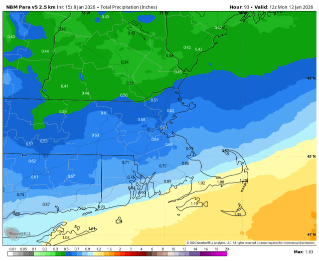
High pressure will slide off to the east tonight, with winds shifting into the southwest, bringing some milder air in. Friday will be relatively mild (by January standards), but clouds will be streaming in ahead of a low pressure system headed for the Great Lakes. As that system moves into Quebec some showers are likely ahead of it Friday evening before a cold front moves through overnight. That front will stall out south of New England allowing some cooler air to move back in. Meanwhile, another low pressure system will head towards the Great Lakes, trying to bring that front back northward as a warm front. As that system moves into Ontario, a secondary low pressure system will develop off the Mid-Atlantic coastline., preventing that warm front from moving in, and giving the new low pressure area a path eastward. This will bring more substantial and widespread rain in for late Saturday into Sunday morning. However, with the cold air in place, precipitation may start as some sleet or freezing rain well north and west of Boston, mainly interior southern New Hampshire and northern Worcester County, as the rain moves in later Saturday. A few additional rain or snow showers in the afternoon as an upper-level low pressure area crosses the Northeast, then high pressure builds in for Monday with cooler and drier conditions. For the Patriots game Sunday evening, it should be mostly cloudy at kickoff, winds out of the northwest at 5-10 mph, with a game time temperature around 37, dropping into the lower 30s by the end of the game.
Much of the area could receive between half an inch and one inch of rainfall this weekend. Image provided by WeatherBell.
Thursday night: Becoming partly to mostly cloudy. Low 22-29.
Friday: More clouds than sun, becoming breezy in the afternoon, showers possible towards evening. High 41-48.
Friday night: Cloudy with showers likely, mainly before midnight. Temperatures continue to rise until midnight, then drop to 33-40 by daybreak.
Saturday: Mostly cloudy with rain developing from southwest to northeast, possibly starting as some sleet or freezing rain well north and west of Boston. High 40-47.
Saturday night: Any mixed precipitation changes to all well rain north and west of Boston, periods of rain elsewhere. Low 33-40.
Sunday: Rain ends by midday, mostly cloudy with a few more rain or snow showers possible late in the day. High 38-45.
Despite the wet start to the weekend, drier weather is expected for much of the time.
A healthy drink of water tonight will help put a dent on the drought. Images provided by Pivotal Weather.
Low pressure moving up the Appalachians will bring some rain into the region this evening, possibly heavy at times for a while. As the system lifts northward, the rain will taper off and end from south to north before daybreak as temperatures rise thanks to increasing southwest winds. Temperatures may top 60 Friday morning in many areas before the storm drags a cold front across the region. Gusty west winds will usher cooler air in, with temperatures dropping through the afternoon. High pressure builds in for the weekend, but with an upper-level low moving through we’ll still have some clouds at times, and winds will remain gusty on Saturday. By Monday, we’ll see clouds start to move back in ahead of a fast-moving storm system moving out of the Great Lakes, with some showers possible at night.
Wind gusts of 30-40 mph or higher are likely across the region Friday afternoon. Image provided by WeatherBell.
Thursday night: Rain likely, possibly heavy for a while through the evening, ending before daybreak, breezy. Low 48-55.
Friday: Intervals of clouds and sunshine, windy. High 54-61 in the morning, temperatures drop in the afternoon.
Friday night: Partly cloudy, breezy. Low 39-46.
Saturday: Partly to mostly sunny, breezy. High 50-57.
Saturday night: Clear to partly cloudy. Low 31-38, a little milder across Cape Cod.
Sunday: A mix of sun and clouds. High 48-55.
Sunday night: Partly cloudy. Low 30-37, a little milder across Cape Cod.
Despite last week’s heavy rain, we’re still in a drought for much of the region and really need more rain. Well, we are going to get some today.
A cold front will produce showers and thunderstorms this morning as it moves through. Loop provided by Weathermodels.com
A strong cold front will cross the region this morning. Ahead of this front we can expect some heavy rain, maybe a rumble of thunder, and some gusty winds. While this could have some impacts on the morning commute, it will be short-lived, as the rain should end with the front moving offshore by early afternoon. Gusty west winds behind the front will send temperatures downward through the afternoon. We’ll clear out at night as high pressure builds in, giving us some sunshine on Tuesday, but clouds will quickly return Tuesday night ahead of another cold front. This one will produce more showers Wednesday morning, but it will also move through fairly quickly, with skies starting to clear out in the afternoon. High pressure then builds in with cooler weather for the end of the week, but with an upper-level low moving in, we’ll see some clouds each day, and possibly a few showers at times. The upper-level low lifts out over the weekend as high pressure moves overhead with dry and cool conditions.
Temperatures will be below normal for the end of the week and the weekend. Image provided by WeatherBell.
Monday: Rain likely during the morning, possibly heavy at times, ending from west to east by early afternoon, skies start to clear out late in the day, breezy, especially during the morning and early afternoon. High 60-67 in the morning, temperatures start falling in the afternoon.
Monday night: Becoming partly cloudy to clear with diminishing winds. Low 44-51.
Tuesday: Mostly sunny, some clouds start to move back in late in the day. High 58-65.
Tuesday night: Becoming mostly cloudy with showers developing before daybreak. Low 47-54, temperatures may rise a little overnight.
Wednesday: Showers likely during the morning, ending by early afternoon, followed by clearing late in the day, breezy. High 60-67.
Wednesday night: Clear to partly cloudy. Low 40-47.
Thursday: Sunshine and some afternoon clouds, a sprinkle is possible, breezy, cooler. High 54-61.
Thursday night: Clear to partly cloudy. Low 37-44.
Friday: A mix of sun and clouds, slight chance for a shower. High 52-59.