Weekly Outlook: July 27-August 2, 2020

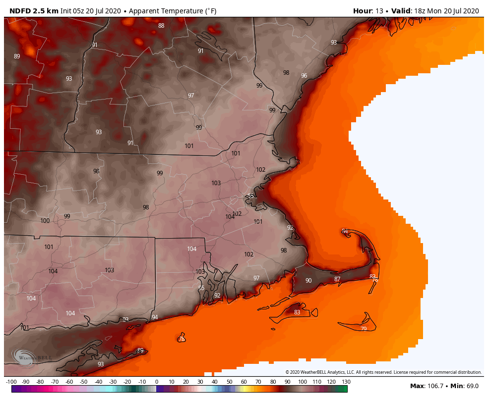
Heat and humidity continue across the region for a couple more days before relief arrives on Wednesday.

Heat Advisories are in effect for much of the region for today and Tuesday. Image provided by Pivotal Weather.

A ridge of high pressure remains in control, so stifling heat and humidity will remain in place until Tuesday. Today looks to be the hottest day, with temperatures well into the 90s. A few places could reach 100, but triple-digit heat shouldn’t be widespread. It will be very humid as well, sending the heat index well above 100 across the region, but dewpoints may actually drop a bit during the afternoon. Tonight will be downright uncomfortable without air conditioning, as low temperatures will only drop into the middle to upper 70s in many areas, and some urban areas, especially Boston, may not drop below 80.

Temperatures may struggle to drop below 80 in some spots Monday night. Image provided by WeatherBell.

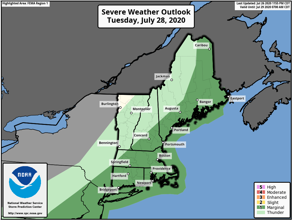
Tuesday will start off very warm and humid, so it won’t take much to send temperatures above 90 once again, but clouds will also start to increase in the afternoon as a cold front approaches the region. This front may produce a few showers and thunderstorms late in the day and at night. Some of these storms may produce some heavy downpours and gusty winds, but we’re not expecting widespread severe weather.

There is a marginal risk for severe weather on Tuesday across the region. Image provided by the Storm Prediction Center.

The front slides offshore early Wednesday, then high pressure builds in for the rest of the week and into the weekend. It be a bit cooler, but still near to a little above normal for the end of July, but the more noticeable effect will be that it is drier, with dewpoints only in the 50s to lower 60s.

Monday: Sunshine and some high clouds around, hot and humid. High 92-99.

Monday night: Clear to partly cloudy. Low 72-79.

Tuesday: Sunny early, then clouds move in with some showers and thunderstorms possible late in the day. High 90-97.

Tuesday night: Showers ending during the evening, though possibly lingering for much of the night near the South Coast. Low 67-74.

Wednesday: Lingering clouds along the South Coast early, otherwise becoming partly to mostly sunny and not as humid. High 85-92.

Thursday: Sunshine and some afternoon clouds. High 83-90.

Friday: A mix of sun and clouds. High 81-88.

Saturday: Partly to mostly sunny. High 81-88.

Sunday: Partly sunny. High 82-89.

Model forecasts for the track of a tropical disturbance in the Central Atlantic. Image provided by WeatherBell,

Finally, we’ll mention the tropical disturbance in the Central Atlantic, since the hype train is already getting set to leave the station. Yes, there are a few models that show a potential threat to the East Coast in about 7-10 days. These should be treated the same as model forecasts in January that show a raging blizzard 7-10 days out. The probability of it happening is still fairly low. The system itself hasn’t even become a tropical depression yet. That may occur later Monday or Tuesday. If (when?) it does, we’ll write a blog post about the storm and it’s future. For now, it has our attention, but that’s it.

Weekly Outlook: July 20-26, 2020

This week will feature a little bit of everything, at least in terms of summer weather.

Heat Advisories are in effect for much of the I-95 corridor from Portland, ME to Richmond, VA again today. Image provided by Pivotal Weather.

We start the week off with more heat and humidity today. Offshore high pressure continues to pump hot and humid weather in, and as a result, Heat Advisories remain in effect for a large portion of the region. Highs will get into the 90s again for much of the area today, with dewpoints in the upper 60s to middle 70s. That combination of heat and humidity will make it feel like its 100 or higher during the afternoon. Relief is on the way though, as a cold front will move across the region later today. This front may produce some showers and thunderstorms, but we’re not that confident that we’ll see widespread activity. Any storms that do form may produce heavy downpours and strong winds, but a severe weather outbreak doesn’t look likely at this point.

The combination of heat and hmidity will make it feel like its over 100 this afternoon. Image provided by WeatherBell.

The front moves offshore tonight, and “cooler” and “drier” air settles in for Tuesday. While it won’t exactly be a lot cooler or a lot drier, it will still be more comfortable compared to today. Our respite doesn’t last long though as a warm front approaches on Wednesday. While the front may produce a few showers or thunderstorms, the more noticeable impact will be to bring the humidity back in. It’ll be quite warm as well, but cloud cover will prevent us from getting too hot once again.

We need any rain we can get. Precipitation is well below normal over the past couple of months across the region. Image provided by the Northeast Regional Climate Center.

Another cold front approaches on Thursday, with more showers and thunderstorms expected. Again, some of them could be quite strong, but a widespread severe weather event doesn’t appear likely at this time. Much cooler and drier weather does finally move in behind this front for Friday and Saturday. As for next Sunday, that’s a bit of a question mark at this point. Most of the models show a storm system passing to the north, but that’s where the similarities end and the story of Goldilocks and the Three Bears starts. One model has little to no precipitation, with hot and humid conditions. Another has it warm but dry with precipitation moving in at night. A third model has it cloudy and mild with showers during the afternoon. We’re going to play the middle ground right now, knowing full well that we’ve got plenty of time for the models to find some common ground and decide on a solution before we issue our Weekend Outlook Thursday afternoon.

Dewpoints in the 40s and 50s by Saturday would be a welcome change. Image provided by Weathermodels.com

Monday: Some dense fog along the South Coast early, otherwise a mix of sun and clouds with some showers and thunderstorms developing during the afternoon. A few of the storms may produce gusty winds and heavy downpours. High 89-96, cooler right along the South Coast. Heat indices could reach as high as 104 in some spots.

Monday night: Clearing and less humid. Low 65-72.

Tuesday: Sunshine and a few clouds. High 85-92.

Tuesday night: Clear to partly cloudy. Low 63-70.

Wednesday: Partly sunny and humid with some afternoon and evening showers and thunderstorms possible. High 82-89, cooler along the coast.

Thursday: Intervals of clouds and sun with some showers and thunderstorms during the afternoon and evening, breezy. High 82-89.

Friday: Partly to mostly sunny and drier. High 77-84.

Saturday: Sunshine and some high clouds. High 80-87.

Sunday: More clouds than sun with showers and thunderstorms possible late in the day and at night. High 83-90.

Weekly Outlook: July 13-19, 2020

Much of this week will feature typical summer-time weather in New England, with warm to hot temperatures, humidity levels ranging from somewhat comfortable to not very comfortable, and some pop-up showers and thunderstorms.

There is a marginal risk for a few severe thunderstorms this afternoon and evening. Image provided by the Storm Prediction Center.

The week starts off with the most active weather day as a cold front starts to approach the region. A few showers are likely this morning as an upper-level disturbance swings through, but we should see some sunshine develop by midday. How much sunshine we get will help determine how much the atmosphere will destabilize again in the afternoon. As the front moves in from the west, showers and thunderstorms will develop. Many of these storms will produce heavy downpours, and some could redevelop over the same locations, resulting in some flash flooding. Depending on how much sun we see in the late morning and early afternoon, we could be looking at some severe storms, with strong winds and hail as well. There is even a slight chance for a tornado to form. How quickly the front moves will also help determine how long we’ll be dealing with the storms, and what areas have the best chance to have them. Right now, it looks like most of the storms will be during the 1pm-8pm time frame.

The HRRR model depicts a possible scenario for thunderstorm development today. Loop provided by Weathermodels.com

The front moves offshore tonight, and cooler and drier air starts to settle in. However, an upper-level low pressure area will be moving in at the same time. As this upper-level low moves right across New England on Tuesday, it will help produce another round of showers and thunderstorms during the afternoon. Most of these shouldn’t be strong, but with a pool of cold air aloft, we could see some small hail in a few of them.

Dewpoints could drop into the upper 50s to lower 60s by Wednesday afternoon. Image provided by WeatherBell.

The upper-level low moves offshore for Wednesday, and we’ll be under the influence high pressure for Wednesday and Thursday, with sunshine, seasonably warm temperatures (tempered by a seabreeze along the coast), and moderate humidity levels. Warmer and more humid air moves in for Friday and the weekend. A series of weak upper-level disturbances will also move across the region, creating a daily chance for showers and thunderstorms.

Heat and humidity return to the region next weekend. Image provided by Pivotal Weather.

Monday: A few showers early, then becoming partly sunny. Showers and thunderstorms are likely during the afternoon and evening. Some of them may produce heavy downpours. High 82-89.

Monday night: Showers and thunderstorms end during the evening, then skies clear out. Low 62-69.

Tuesday: A sunny start, then clouds develop with a few showers and thunderstorms likely during the afternoon. High 76-83.

Tuesday night: Clear to partly cloudy. Low 59-66.

Wednesday: Sunshine and a few clouds. High 72-79, coolest along the coast.

Thursday: Some patchy morning fog, then becoming partly to mostly sunny. High 74-81, coolest along the coast.

Friday: Intervals of clouds and sunshine with some showers and thunderstorms possible, especially during the morning, a little more humid. High 77-84.

Saturday: Partly sunny, chance for a shower or thunderstorm. High 83-90, cooler along the coast.

Sunday: A mix of sun and clouds, a shower or thunderstorm is possible. High 86-93.

Weekly Outlook: July 6-12, 2020

We’ve got some typical summertime weather coming up for most of the week, with heat, humidity, and thunderstorms all expected.

The week starts off with high pressure building in from the north, which will bring in sunshine, lower humidity, and slightly cooler temperatures, especially along the coast. By Tuesday, however, that high will move off to the south, allowing more humid air into the region, along the the chance for a few showers and thunderstorms.

You’ll start to hear the “Triple-H” talk for Wednesday through Friday, but it may not quite qualify. It’ll be quite warm to hot, with temperatures will into the 80s and lower 90s in many locations. It’ll also be quite humid, as dewpoints will get well into the 60s, and possibly even lower 70s. Will it be hazy? Probably not. Even without the haze, it’ll still be quite comfortable for a lot of people.

Dewpoints could be in the 70s across the region by Friday afternoon. Image provided by Weathermodels.com

The end of the week and into the weekend is a bit of a question mark right now. Low pressure currently over the Southeast will move off the Carolina coastline by midweek, and then head northeastward up the coastline. The National Hurricane Center has already given it a 40% chance of development before the end of the week. Given their recent track record, we’re assuming that assuming it moves off the coast, as long as it’s spinning and has a thunderstorm nearby, it’ll be called Tropical Depression Six, or maybe they’ll go right to Tropical Storm Fay. Either way, it may very well have some impact here by Friday or Saturday. The most likely impact is for some heavy rainfall. We’ll already have a very soupy airmass in place, and adding tropical air to that will help wring out even more moisture. While this will help put a dent in the developing drought for some areas, it may also lead to flooding in others. We could also see some impacts from wind, depending on the development of the system, and rough surf along the coast. Unsettled weather may hang around through the weekend, as the system may be slow to depart.

Low pressure over the Southeast could become a tropical system and track up the coast later this week. Image provided by the National Center for Atmospheric Research,

Monday: Partly to mostly sunny. High 77-84, cooler along the coast.

Monday night: Partly cloudy. Low 57-64.

Tuesday: A mix of sun and clouds, just a slight chance for an afternoon shower or thunderstorm. High 76-83.

Tuesday night: Partly cloudy. Low 61-68.

Wednesday: Partly sunny with showers and thunderstorms likely in the afternoon. High 81-88.

Thursday: Sunshine and a few afternoon clouds, a shower or thunderstorm may pop up. High 86-93.

Friday: Early sun, then clouds move in, some showers and thunderstorms develop, possibly become a steady rain late in the day and at night. High 84-91.

Saturday: Rain ends early, then becoming partly sunny, a few showers and thunderstorms are possible in the afternoon and evening. High 80-87.

Sunday: Intervals of clouds and sun, more showers and thunderstorms are possible. High 82-89.

Weekly Outlook: June 29 – July 5, 2020

This is going one of those weeks where the weather app on your phone just won’t cut it. Most of those apps will give you a little icon for the day, and for this week, we wouldn’t be surprised if there was a little thunderstorm icon in there for every day. Yes, there will be a chance of thunderstorms for almost every day this week. However, the vast majority of the time will be dry, and none of the days should be a washout.

Satellite loop showing the explosive development of Sunday’s storms from midday through sunset. Loop provided by the College of DuPage.

After widespread strong to severe thunderstorms on Sunday, things should be a bit more quiet today. We’ve got an upper-level low pressure settling into the northeast, so we’ll see clouds popping up, and some showers and thunderstorms will likely develop this afternoon. This will be nothing like yesterday however. Sure, a few of the storms may produce a quick downpour or even some small hail due to some cold air aloft, but they’ll be hit and miss storms, with more areas getting nothing than areas that get storms. Most of the activity should diminish with the setting sun.

Much of the region received beneficial rain on Sunday. From northern Rhode Island into Metro Boston, rainfall totals of 1-4″ and heavier were common. Image provided by NOAA.

That upper-level low will remain nearby for Tuesday and Wednesday, so we’ll have similar conditions both days with showers and thunderstorms popping up each afternoon, produce a few downpours and maybe a little hail, but nothing widespread is expected. Temperatures will be on the cooler side, possibly even a little below normal for the end of June/beginning of July, with highs only in the 70s for most of us, with some coastal locations possible staying in the 60s thanks to a wind off the water.

Despite the chances for rain every day, we’re not actually expecting a lot of rain this week. Image provided by Weathermodels.com

The upper-level low finally starts to move out on Thursday, but it still may produce a few showers and thunderstorms. After it moves out, a ridge of high pressure starts to build in…..to the Midwest. That means another upper-level trough of low pressure starts to build in for Friday and the weekend. So, we’ll be a bit warmer, but, you guessed it, we’ll have a daily chance for some pop-up showers and thunderstorms. Wash. Rinse. Repeat. Things may start to dry out a bit more on Sunday.

Average high temperatures for the start of July are in the upper 70s to lower 80s. Image provided by Weathermodels.com

Monday: Some patchy fog to start the day, otherwise more clouds than sunshine, chance for some showers and thunderstorms. High 73-80, a little cooler along the coast.

Monday night: Showers taper off in the evening, then partly to mostly cloudy with some fog redeveloping. Low 59-66.

Tuesday: Intervals of clouds and sunshine, chance for a few showers and thunderstorms. High 69-76, a little cooler along the coast.

Tuesday night: Partly to mostly cloudy, again some patchy fog is possible. Low 60-67.

Wednesday: A mix of sun and clouds with some afternoon showers and thunderstorms possible. High 72-79.

Thursday: A sunny start, then clouds pop up, just a slight chance for a shower or thunderstorm. High 80-87, a little cooler along the coast.

Friday: Morning sunshine then afternoon clouds, a shower or thunderstorm may pop up. High 77-84.

Independence Day: Partly sunny with an afternoon shower or thunderstorm possible. High 75-82.

Sunday: Sunshine and a few clouds. High 78-85.

Weekly Outlook: June 22-28, 2020

No matter how you define summer, it is now officially here in the Northern Hemisphere, and we’ll feel it all week long.

The past few days have all featured the same general pattern. A muggy start to the day with low clouds and fog across southern Rhode Island and southeastern Massachusetts, then sunshine, some fair-weather cumulus clouds, warm to hot temperatures, moderate to somewhat high humidity, a few pop-up showers and thunderstorms during the afternoon, diminishing by evening, then low clouds and fog return to the South Coast. Wash. Rinse. Repeat. Well, that general pattern will continue today and Tuesday with one added wrinkle – a seabreeze along the coast. That actually started on Sunday, which helped to produce the heavy thunderstorms across eastern Massachusetts. It will likely be the case today, and probably Tuesday as well.

Locally heavy showers and thunderstorms developed on Sunday. Loop provided by the College of DuPage.

By Wednesday, we start to get some changes. A cold front will be approaching from the west as low pressure passes north of the region. We’ll still have morning low clouds and fog, and it’ll still be warm to hot and fairly humid, but the cold front will help produce a little more in the way of thunderstorm activity Wednesday afternoon and evening. The timing of the front will have a hand in determining how strong the thunderstorms get, but right now, it does not look like a widespread severe event.

Some of Wednesday’s storms could be locally heavy, but a widespread heavy rain event is not likely. Image provided by WeatherBell.

The front moves through at some point Wednesday night early Thursday, then high pressure builds in with some drier weather for Thursday into Friday. Temperatures will still be quite warm, but with lower humidity, it will feel a bit more comfortable. The weekend is a bit of a question mark at this point. Another system will likely pass north of the region, with some showers and thunderstorms possible, but there is plenty of disagreement among the models in regards to the timing of the system. Either way, it doesn’t look like much to worry about, with neither day being a washout.

Dewpoints will drop into the 50s across much of the region Thursday afternoon. Image provided by Weathermodels.com

Monday: Low clouds and fog to start the day across the South Coast, and also from the North Shore to the New Hampshire Seacoast, then skies become partly to mostly sunny, a few showers and thunderstorms are possible during the afternoon, mainly well inland. High 85-92 inland, 77-84 along the coast.

Monday night: Clear to partly cloudy, low clouds and fog return to the South Coast. Low 61-68.

Tuesday: A mix of sun and clouds, chance for a few showers and thunderstorms during the afternoon. High 85-92, cooler right along the coast.

Tuesday night: Clear to partly cloudy, low clouds and fog return to the South Coast once again. Low 63-70.

Wednesday: Intervals of clouds and sunshine with scattered showers and thunderstorms likely during the afternoon and evening, tapering off before midnight. High 83-90, cooler along the South Coast.

Thursday: Partly to mostly sunny and less humid. High 82-89.

Friday: Sunshine and a few clouds. High 81-88.

Saturday: Intervals of clouds and sun with a chance for showers and thunderstorms. High 78-85.

Sunday: Partly sunny, chance for some showers and thunderstorms. High 80-87.

Weekly Outlook: June 15-21, 2020

High ‘N’ Dry – that pretty much sums up this week’s forecast. High pressure provides dry weather for most of the week.

High pressure will settle into the Northeast for the next few days. This means we’ll have dry and cool conditions for the first part of the week, with temperatures and humidity levels starting to creep up as we get to the latter half of the week. As is usually the case, temperatures will be coolest along the coast thanks to onshore flow, and well see some fair-weather cumulus clouds pop up each afternoon across the interior.

Water temperatures are in the upper 50s to lower 60s off the east coast, and lower to middle 60s off the south coast. Image provided by NOAA.

By late in the week, we’ll be warm to potentially hot, and humid, with the chance for some showers and thunderstorms to pop up on Friday afternoon. The weekend is a bit of a question mark at this point. The models have 2 separate but equally plausible solutions right now. One model has the heat come to an abrupt end Saturday afternoon with a backdoor cold front, leading to much cooler conditions for Saturday night and Sunday, along with plenty of clouds and possibly some showers. Some other models keep us warm and humid with some showers and thunderstorms possible, and a slow-moving cold front still well to our west. For now, we’re going to lean towards the latter solution, but obviously things could change. With next Sunday being Fathers Day, many people will be making plans, especially outdoor plans. We should have a clearer picture when we publish our Weekend Outlook Thursday afternoon. If the latter solution is indeed correct, some locations across the interior could be near or above 90 starting on Thursday and continuing at least into Sunday.

Little to no rainfall is expected across the region between now and Sunday morning. Image provided by WeatherBell.

Monday: Some low clouds and fog this morning, then becoming partly to mostly sunny. High 67-74, a little cooler along the coast.

Monday night: Mostly clear. Low 48-55.

Tuesday: Sunshine and lots of it. High 73-80, a little cooler along the coast.

Tuesday night: Clear to partly cloudy. Low 48-55.

Wednesday: Sunshine and a few afternoon clouds. High 79-86, again cooler along the coast.

Thursday: Mostly sunny, a few clouds during the afternoon. High 84-91, cooler along the South Coast.

Friday: Partly to mostly sunny, just a slight chance for an afternoon shower or thunderstorm. High 86-93, cooler along the South Coast.

Saturday: A mix of sun and clouds, an afternoon shower or thunderstorm is possible. High 85-92, cooler along the South Coast.

Sunday: Partly sunny, chance for some afternoon showers and thunderstorms. High 84-91, cooler along the South Coast.

Weekly Outlook: June 8-14, 2020

Heat and humidity will gradually be increasing over the next few days, which means it actually will feel like June.

The first half of the week is a fairly straightforward forecast. High pressure will slide offshore, with generally dry weather through Wednesday. Temperatures and humidity levels will gradually increase thanks to southwesterly flow around the high pressure area.

The week starts off with very low dewpoints, but they’ll gradually rise, especially by Wednesday and Thursday. Loop provided by Pivotal Weather.

By late Wednesday, things start to get a little more complicated. A strong low pressure sure, fueled by whatever is left of “Cristobal”, will be moving across the Great Lakes and into Ontario. It will send a warm front across the region, leading to an increase in humidity levels. The low will move up towards Hudson Bay on Thursday, dragging a cold front into the Northeast. Ahead of that front, it’ll likely be fairly breezy, but also warm and humid, with the front triggering some showers and thunderstorms. There is some disagreement among the models as to when the cold front moves through the region, but right now, we’re leaning towards Thursday night.

Thursday could be a very breezy day, with wind gusts in excess of 40 mph across the region. Image provided by WeatherBell.

High pressure builds in behind the front on Friday with drier conditions. Next weekend is highly uncertain at this point. An upper-level low pressure system may drift across the Northeast, which would result in some additional clouds and cooler conditions, as well as the chance for a few showers. Some models are more pessimistic than others, but given the fact that it’s been dry lately, we’re going to lean away from the models that are showing more widespread rainfall. There’s an old adage we learned a while ago that holds true with forecasting rainfall – “When in drought, leave it out.” We’re going to go with that.

Rainfall has been near to below normal across the region over the past 60 days. Image provided by Weathermodels.com

Monday: Sunshine and a few high clouds. High 72-79.

Monday night: Partly cloudy. Low 53-60.

Tuesday: Mostly sunny in the morning, some clouds pop up during the afternoon. High 77-84.

Tuesday night: Clear to partly cloudy. Low 55-62.

Wednesday: Partly to mostly sunny and breezy, slight chance for an afternoon shower. High 70-80 along the coast, 81-88 inland.

Thursday: Partly sunny, windy, and humid with showers and thunderstorms possible late in the day and at night. High 79-86, cooler along the south coast.

Friday: Clouds and a few lingering showers across southeastern Massachusetts, otherwise becoming partly sunny and less humid. High 79-86.

Saturday: A mix of sun and clouds. High 74-81, cooler along the coast.

Sunday: Intervals of clouds and sun, chance for a few showers. High 71-78, cooler along the coast.

Weekly Outlook: June 1-7, 2020

June has arrived, which means that we are now officially in meteorological summer. It also means that Hurricane Season has officially begun in the Atlantic.

June is starting on a rather cool note with some frost across portions of Northern New England. Image provided by WeatherBell.

We start the week off on a cool note with high pressure at the surface and upper-level trough of low pressure moving across the region. This trough may help produce a few pop-up showers this afternoon, but will also help keep temperatures well below normal today. Another cool night is expected tonight, but not as cool as it was this morning. By Tuesday a warm front will be moving towards the area, with clouds streaming in ahead of it, and possibly a shower or two.

Warmer air moves in on Wednesday as low pressure heads toward the St. Lawrence Valley. With the warm air will be some shower activity and possibly a thunderstorm or two. We’ll remain warm and humid through Thursday and into Friday before another low pressure system passes north of the region. This will bring in more showers and thunderstorms late Friday and Friday night.

Dewpoints will rise into the middle to upper 60s by Friday afternoon. Image provided by WeatherBell.

A cold front moves through early Saturday, but we’ll remain on the warm side with developing sunshine during the afternoon. Drier air will filter in behind the front, then high pressure builds in for Sunday with cooler conditions.

Over the weekend, we published our annual look at the upcoming hurricane season, which also contained some stats about how overdue we are for a storm up here, or, as a colleague said “me thinks our clock be tick’n!” We’ve already had 2 named storms this season (we’re still not convinced that “Bertha” was actually a tropical storm), but another system could be brewing in the Bay of Campeche. Conditions will be favorable for a system to develop later this week, and a majority of the forecast models do show a system developing, but they don’t agree on how strong it could get or where it could go. Obviously, we’ll keep an eye on it, and if it develops, we’ll keep you updated, but it will likely have little to no impact up here, except for possibly some rain as whatever is left of the system moves through, but that would be a good 10 or more days away, if at all.

The 51 members of the ECMWF Ensemble show a wide range in location and strength of a potential tropical system in the Gulf next weekend. Image provided by Weathermodels.com.

Monday: Early sun, then clouds develop, with a chance for a few afternoon showers. High 59-66.

Monday night: Clear to partly cloudy. Low 43-50.

Tuesday: Thickening clouds, a few showers are possible late in the day. High 66-73.

Tuesday night: Partly to mostly cloudy with scattered showers. Low 51-58.

Wednesday: Intervals of clouds and sunshine, chance for a few showers, especially along the south coast. High 73-80.

Thursday: A mix of sun and clouds. High 77-84.

Friday: Becoming partly to mostly cloudy, chance for a few showers. High 79-86.

Saturday: Morning showers, then becoming partly to mostly sunny. High 77-84.

Sunday: A mix of sun and clouds. High 67-74.

Weekly Outlook: May 25-June 1, 2020

Memorial Day is the “traditional start of summer”, and we’ll certainly have some summer-like weather this week, just not on Memorial Day.

The forecast for this week is actually fairly simple. We start the week out with plenty of low clouds and some fog for your Memorial Day morning. With high pressure east of Nova Scotia and low pressure south of New England, a light southeast flow is bringing in plenty of moisture in the form of cloud cover. Some patchy drizzle is possible along the coast as well. As we head into the afternoon, the clouds will start to break up away from the coast, allowing for some sunshine, but the low clouds and fog/drizzle may hang tough along the coast. The cloudcover, combined with winds blowing off the still-chilly Atlantic, will keep temperatures well below normal along the coast, but inland, temperatures will be much warmer, especially where sunshine develops. The low clouds and fog return Monday night, but things start to change in a big way on Tuesday.

The nighttime microphysics image from the GOES satellite shows the low clouds and fog spread across eastern Massachusetts Sunday evening and night. Loop provided by NOAA.

By Tuesday, high pressure will settle southward, with more of a south to southwest flow developing across the Northeast, this will allow warmer air to start to move in. Temperatures should jump into the 70s and lower 80s, but coastal locations, especially ones facing south, will stall cooler. Wednesday should feature even warmer weather. By Thursday, you’ll start to notice an increase in humidity, with a few pop-up showers possible in the afternoon.

Temperatures could approach 90 well inland on Wednesday. Image provided by WeatherBell.

As we head into Friday, a cold front will be approaching the region. This will bring in more cloudcover, with showers and thunderstorms expected, especially during the afternoon and evening. How much sunshine we get and when the front actually moves through will determine how warm we’ll get and how strong the storms will be. We’ll have more clarity on that situation on Thursday in our Weekend Outlook. Behind the front, high pressure builds in for the weekend with drier conditions.

Dewpoints could get into the middle to upper 60s across the region ahead of the cold front on Friday. Image provided by Weathermodels.com

Memorial Day: Low clouds and fog along with some patchy drizzle during the morning, then skies become partly sunny away from the coast in the afternoon. Some sunny breaks may develop along the coast late in the day. High 64-71, except 56-63 right along the coast.

Monday night: Low clouds and fog return. Low 50-57.

Tuesday: Becoming partly to mostly sunny. High 79-86, cooler along the coast.

Tuesday night: Clear to partly cloudy during the evening, low clouds and fog may move back in, especially along the coast. Low 56-63.

Wednesday: Partly to mostly sunny. High 83-90, cooler along the coast.

Thursday: Sunshine filtered through some high clouds, breezy, more humid, chance for a pop-up shower or thunderstorm in the afternoon. High 82-89, much cooler along the coast.

Friday: Partly to mostly cloudy, breezy, and humid with showers and thunderstorms likely during the late afternoon and evening. High 76-83.

Saturday: Becoming partly to mostly sunny. High 72-79.

Sunday: A mix of sun and clouds. High 68-75.