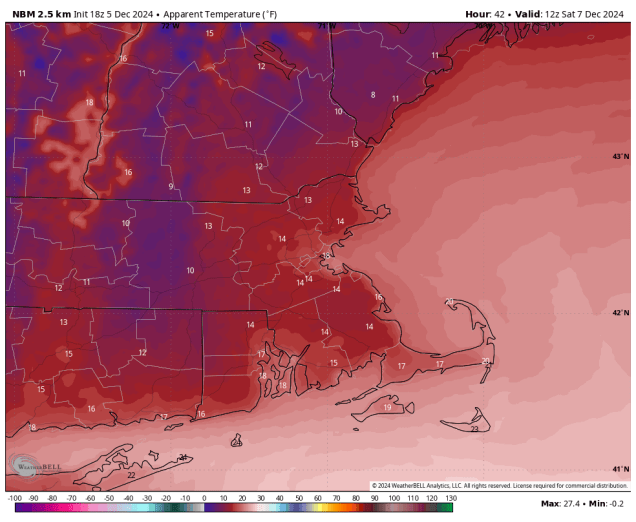
There is a little bit of snow in our future, but also a slight moderation in our temperatures as well.
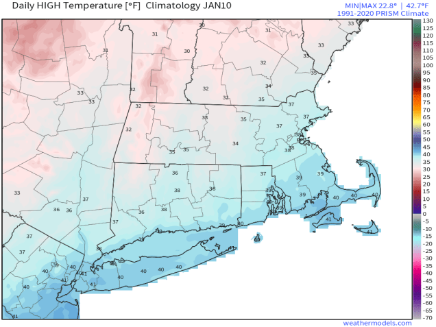
High temperatures should be in the middle-to-upper 30s at this time of year. Image provided by Weathermodels.com
The large storm system that has been sitting over Atlantic Canada for much of the week giving us gusty winds, cold temperatures, and occasional snow showers/flurries will finally loosen its grip on the region over the next day or so. Winds will finally start to diminish during the day on Friday, and temperatures will start to moderate, getting back to near to even a little normal for early January on Friday. On Saturday, the low pressure system that some of the models tried to develop into a blockbuster blizzard will pass well south of the region, with no impact at all here. However, an upper-level disturbance will move through, with some light snow or snow showers Saturday morning and into part of the afternoon. For most of the region, accumulations will be an inch or less, but a few spots could pick up 2 inches or so. Once that system pulls away, high pressure builds in with seasonably cold and dry conditions for Sunday and Monday.
Most places will receive less than 1″ of snow om Saturday. Image provided by WeatherBell.
Thursday night: Clear skies, still breezy. Low 18-25.
Friday: Lots of sunshine, winds diminish during the afternoon. High 33-40.
Friday night: Increasing and thickening clouds. Low 19-26.
Saturday: Light snow or snow showers develop in the morning, ending in the afternoon. A coating to 2 inches of accumulation is expected. High 29-36.
Colder weather is on the way as get to the first weekend of the year.
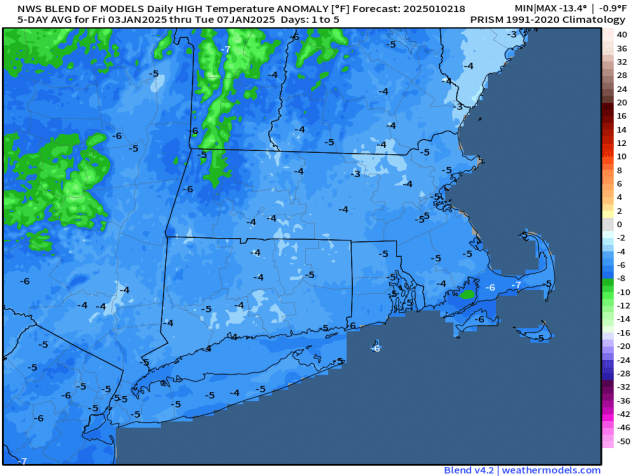
Temperatures will be below normal through the weekend. Image provided by Weathermodels.com
The forecast through Sunday is pretty straightforward. High pressure builds in with progressively colder weather through Sunday, exacerbated by gusty winds at times, but it will remain dry. Things could get a little complicated on Monday. Low pressure will move off the Mid-Atlantic coastline, producing a decent-sized snowstorm for Washington, D.C. and nearby locations. The storm will pass south of New England, but could get close enough to produce a little light snow or some snow showers near the South Coast, but this is far from a lock.
There is a very low chance for some light snow near the South Coast on Monday. Image provided by WeatherBell.
Thursday night: Clear to partly cloudy, breezy. Low 24-31.
Friday: Mostly sunny, breezy. High 32-39.
Friday night: Clear to partly cloudy. Low 18-25.
Saturday: A mix of sun and clouds, breezy. High 26-33.
Saturday night: Partly cloudy. Low 15-22.
Sunday: Partly sunny, breezy. High 25-32.
Sunday night: Partly cloudy. Low 14-21.
Monday: Intervals of clouds and sun, slight chance for a few snow showers near the South Coast. High 25-32.
If you’re happy that you had a White Christmas but want the snow gone now then you’re in luck because it will turn milder this weekend, but there’s also some rain on the way, and possibly some icing issues as well.
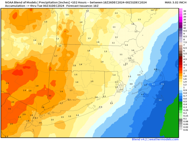
Much of the region could pick up an inch or more of rain between now and Monday evening. Image provided by Weathermodels.com
High pressure will keep us dry into Saturday, with temperatures gradually moderating, helping to melt a little bit of the snow, but we’ll see clouds start to move in Friday night and Saturday as low pressure begins to head our way. Showers will move in late Saturday and Saturday night ahead of a warm front, but across the interior, especially from central and northeastern Massachusetts into southern New Hampshire, temperatures may be near or just below freezing Saturday night, which could result in some freezing rain for a while. Keep this in mind if you are going to be out and about in those areas Saturday evening and night. Temperatures should slowly warm up Sunday morning allowing the precipitation to change to all rain, with occasional showers likely during the day on Sunday. The low pressure system itself moves in for Sunday night and Monday, bringing some steadier and heavier rain in, allowing us to put another dent into the ongoing drought. The rain moves out during the day on Monday, with some clearing possible by late in the day.
Freezing rain could be an issue north and west of Boston Saturday night. Image provided by WeatherBell.
Thursday night: Gradual clearing across Cape Cod, clear to partly cloudy elsewhere. Low 12-19, milder across southeastern Massachusetts and Cape Cod.
Friday: Sunshine in the morning, clouds start to filter in during the afternoon. High 35-42.
Friday night: Becoming partly to mostly cloudy. Low 20-27, a little milder across Cape Cod.
Saturday: Mostly cloudy with a few showers around during the afternoon. High 32-39, except 40-47 across southeastern Massachusetts and Cape Cod.
Saturday night: Cloudy with some occasional showers, some freezing rain or freezing drizzle likely outside of I-495. Low 30-37 north of the Mass Pike, except 37-44 across southeastern Massachusetts and Cape Cod, with temperatures possibly rising after midnight.
Sunday: Cloudy with more showers, possibly some freezing drizzle or freezing rain across southern New Hampshire in the morning. Some steadier rain may move in late in the day. High 39-46 north of Route 2, 46-53 south of Route 2.
Sunday night: Periods of rain, some of it could be heavy. Low 37-44 during the evening, temperatures may rise overnight.
Monday: Rain ends in the morning, some clearing possible late in the day, breezy. High 48-55.
The winter solstice takes place at 4:20am Saturday, marking the official start of astronomical winter. Mother Nature is going to be sure you know that winter has arrived this weekend.
The winter solstice occurs at 4:20am Saturday. Days start getting longer from Saturday until June. Images provided by the Farmer’s Almanac.
An Alberta Clipper moves across the Great Lakes tonight, sending clouds back into the region. That system will head toward the Mid-Atlantic states and then offshore, becoming a rather potent system as it passes south and east of the region later Friday into Saturday. It may be just close enough to bring some rain or snow showers to Cape Cod, but with the counter-clockwise flow around the system, northeast winds blowing over the still relatively mild Atlantic will bring some ocean-effect snow showers to parts of our area later Friday into Friday night. This won’t be a big deal, but it may slow-down the Friday evening commute a little. Right now, it looks like most places will see less than 2 inches of snow from this system. Rain will eventually change to snow across Cape Cod, with 1-2 inches possible there as well.
A little snow is expected across the region Friday and Friday night. Image provided by Weathermodels.com
The storm pulls away on Saturday and high pressure builds in, with northerly winds ushering in some of the coldest air so far this season from later Saturday into Monday. While most of the region will be sunny and cold Sunday, the northerly winds will bring clouds back into the Outer Cape, with some additional snow showers likely that could produce additional accumulations. Monday looks dry and cold, with clouds starting to move back in late in the day ahead of the next storm system.
Wind chills will be near or below zero if you’re heading out the door early Sunday. Image provided by WeatherBell.
Thursday night: Becoming mostly cloudy. Low 24-31, little milder across Cape Cod.
Friday: Cloudy and becoming breezy with snow showers developing, except rain showers across southeastern Massachusetts and Cape Cod, changing to snow showers late in the day. High 32-39, a little milder across southeastern Massachusetts and Cape Cod.
Friday night: Mostly cloudy with scattered snow showers, breezy along the coast. Low 21-28, little milder across Cape Cod.
Saturday: More clouds than sunshine, snow showers continue across Cape Cod, but end early elsewhere, breezy. High 28-35.
Saturday night: Becoming clear and cold, except across the Outer Cape where it will remain cloudy with some additional snow showers. Low 9-16, a little milder across the Outer Cape.
Sunday: Partly to mostly cloudy with snow showers across the Outer Cape, mostly sunny, breezy, and cold elsewhere. High 19-26.
Sunday night: Plenty of clouds with a few more snow showers across the Outer Cape, clear elsewhere. Low 6-13, a little milder across the Outer Cape.
Monday: Partly to mostly sunny, clouds start to move in late in the day. High 24-31.
Quiet weather is expected for much of the upcoming weekend.
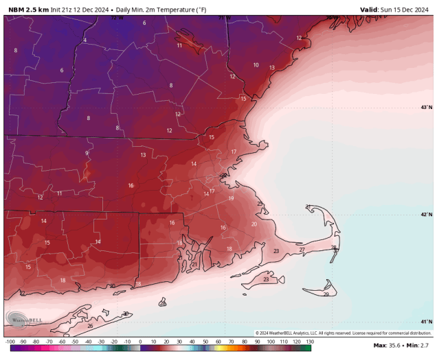
Sunday morning is looking rather chilly. Image provided by WeatherBell.
High pressure will build in and remain in control of our weather into Saturday, with dry and chilly conditions expected. As the high moves off to the east on Sunday, we’ll start to moderate, but also see clouds start to stream in ahead of a weak system. That system may bring in some rain showers on Monday, though it could start as some snow across the interior, mainly north and west of Interstate 495.
Some unsettled weather may move in on Monday, but it’s not definite at this point. Images provided by Pivotal Weather.
Thursday night: Clear to partly cloudy with diminishing winds. Low 19-26.
Friday: Sunshine and a few clouds. High 28-35.
Friday night: Clear skies, a few clouds across parts of Cape Cod. Low 15-22.
Saturday: Plenty of sunshine. High 29-36.
Saturday night: Clear to partly cloudy. Low 14-21, a little milder across Cape Cod.
Sunday: Increasing and thickening clouds. High 32-39.
Sunday night: Becoming mostly cloudy. Low 24-31.
Monday: Plenty of clouds with some showers possible, maybe starting as some snow outside of I-495. High 40-47.
We’ve got a couple of chilly days coming up, but a warmup is in store for the end of the weekend.
Wind chills will be in the teens Saturday morning. Image provided by WeatherBell.
The storm system that brought us snow earlier today continues to pull away and a cold front moves through this evening with a few snow showers or squalls, setting the stage for a couple of chilly days across the region. Gusty west to northwest winds usher much cooler air in for tonight and Friday as skies clear out with high pressure building in. Many places may not reach freezing on Friday, and wind chills will be in the teens in spots. Saturday looks fairly chilly as well, but we’ll see some clouds stream in ahead of another fast-moving storm system. That system passes north of the region Saturday night and early Sunday, with a few snow showers possible, mainly north of the Mass Pike. We’ll start to turn milder on Sunday as winds become southwesterly. Monday will see more clouds move in ahead of another storm system, which brings in some showers during the afternoon, but south to southwest winds will send temperatures back up well into the 40s.
Some places could make a run at 50 on Monday. Image provided by Weathernodels.com
Thursday night: Any lingering snow showers end in the evening, becoming clear to partly cloudy, breezy. Low 21-28.
Friday: Sunshine and some afternoon clouds, breezy. High 28-35.
Friday night: Clear to partly cloudy. Low 17-24.
Saturday: Sunny in the morning, then clouds move in during the afternoon. High 31-38.
Saturday night: Becoming mostly cloudy, chance for some late-night snow showers, mainly north of the Mass Pike. Low 20-27.
Sunday: Morning clouds and a few snow showers north of the Mass Pike, some clearing late in the day. High 38-45.
Sunday night: Partly cloudy. Low 27-34.
Monday: Becoming mostly cloudy, showers develop in the afternoon. High 43-50.
Turkey Day is looking wet, but after that things will turn colder around here.
Below normal temperatures are expected through the holiday weekend. Image provided by Weathermodels.com.
Low pressure will move out of the Tennessee Valley tonight and head towards Southern New England, passing near or just south of the South Coast on Thanksgiving Day. For most of us, we’ll see rain developing around daybreak, and ending in the evening, but across the hills from Worcester County into the Monadnocks of southwestern New Hampshire, some snow is likely, with a few inches possible. Across the rest of southern New Hampshire, we may see the rain start as snow in the morning, but it should quickly change to rain, with little to no accumulation. Farther north, especially north of Concord, NH, a few inches may accumulate, before a change to rain occurs. The system starts to pull away Thursday evening, with the rain ending before midnight, though we could see some flakes mix in as the rain winds down.
Any accumulating snow should stay well north and west of Boston on Thursday. Image provided by WeatherBell.
As the storm moves into Atlantic Canada, we’ll clear out for Friday with breezy and colder conditions. A few stray rain or snow showers are possible, especially across Cape Cod where the winds blowing over the still relatively mild water may generate some ocean-effect showers. Another weak disturbance moves through Friday night with just a few flurries, then even colder air settles in for the weekend and Monday. With an upper-level low over the Northeast and disturbances rotating around it, we could see a few widely scattered flurries or snow showers each day.
Wind chills will be in the teens Sunday morning. Image provided by Weathermodels.com
Wednesday night: Becoming cloudy, rain may develop towards daybreak, mixed with snow well north and west of Boston. Low 29-36, temperatures may start to rise after midnight.
Thursday: Periods of rain, mixed with snow in the morning, especially from the hills of Worcester County into southern New Hampshire, becoming breezy along the coast. High 39-46 north and west of I-95 47-54 south and east of I-95.
Thursday night: Rain ending before midnight, possibly mixed with some wet snow, some clearing late at night, breezy along the coast during the evening. Low 30-37.
Friday: Partly to mostly sunny. High 40-47.
Friday night: Clear to partly cloudy, chance for a few rain or snow showers across Cape Cod. Low 25-32.
Saturday: Sunshine and some afternoon clouds, slight chance for a few flurries, especially across the Outer Cape, breezy, colder. High 37-44.
Saturday night: Partly cloudy. Low 22-29.
Sunday: A mix of sun and clouds, chance for a few flurries, breezy, chilly. High 35-42.
Much-needed rain has finally made its way to the region, and more is coming.
Much of the region could pick up an inch or more of rain by the end of the weekend. Image provided by Weathermodels.com
After weeks without significant rainfall, we finally had some move in today as low pressure moved south of New England. An upper-level low pressure system will move out of the Great Lakes and into the Northeast, pulling that system into New York and Pennsylvania tonight, which means the steady rain this evening will taper off to showers overnight. The upper low then moves in for Friday, and while there could be some sunny breaks in the morning, for the most part we’ll have plenty of clouds with a few showers around. With some cold air aloft, there could be a few snowflakes mixed in, especially across the higher terrain of central Massachusetts and southwestern New Hampshire. A disturbance rotating around that upper-level low will trigger a new storm system south and east of New England, bringing rain and gusty winds back in for late Friday into early Saturday, mainly across eastern Massachusetts and Rhode Island. If the precipitation shield can extend far enough west, the rain may change to snow across the hills of Worcester County and the Monadnocks of southern New Hampshire. That low pulls away on Saturday, but we’ll be slow to clear out, with a gusty northwest breeze keeping us on the cool side. High pressure builds in for Sunday with more sunshine, but there will still be some clouds around with the upper-level low nearby. Monday starts off with some sun, but then clouds start to move back in during the afternoon as another storm system heads this way from the Great Lakes. This will likely bring in more rain showers for Monday night and Tuesday.
Wind gusts of 30-40 mph are possible this weekend. Image provided by WeatherBell.
Thursday night: Rain tapers off to showers, ending overnight, some partial clearing possible late at night, breezy. Low 38-45.
Friday: Some sunshine in the morning, then clouds return with a few showers around, becoming a steadier rain late in the day across eastern Massachusetts and Rhode Island, possibly mixed with some wet snow across the higher terrain from central Massachusetts into southern New Hampshire. High 46-53.
Friday night: Periods of rain, mainly across eastern Massachusetts and southern New Hampshire, possibly mixed with some wet snow across the higher terrain from central Massachusetts into southern New Hampshire. Low 34-41.
Saturday: Cloudy and breezy with showers (or wet snow) ending in the morning, though there could be a few more showers around in the afternoon. High 43-50.
Saturday night: Partly to mostly cloudy, breezy. Low 35-42.
Sunday: A mix of sun and clouds, windy. High 44-51.
Sunday night: Clear to partly cloudy. Low 30-37.
Monday: Morning sun, clouds start to move back in during the afternoon. High 47-54.
Finally, since the hype train already left the station yesterday, we’ll address the possibility of a “White Thanksgiving”. Yes, a couple of models have occasionally shown the potential for a storm system next weekend. However, these models have been highly inconsistent at that range, and they vary widely on the track, strength, and timing of the potential system, and what, if any, impact it might have here. Anything from wind-swept rain to heavy snow, to a sunny but cool weekend is on tap. It’s just WAY too early to even speculate on what might happen a week from now. We’ll address it a little more in our Weekly Outlook early Monday, but even then, the details will probably still be a fuzzy. Bottom line: don’t worry about it, don’t go cancelling any Thanksgiving weekend plans, and stay tuned for further updates. If there is anything to worry about, we’ll let you know well in advance.
The models all have very different solutions for Thanksgiving Day. Images provided by Pivotal Weather,
After a few chilly days, a warmup is in store for the weekend.
Temperatures will be above normal again this weekend. Image provided by Weathermodels.com
High pressure will keep us dry for the next few days, but that doesn’t mean it’s a simple forecast. A weak system passing well to our south and west tonight will spread some high clouds in, which will be just enough to keep us from getting as cold as last night. As that system pulls away on Friday, a bigger storm moving into Atlantic Canada will start to drift westward, sending more clouds our way during the afternoon, and these will be a little thicker, especially along the coast. However, we’ll also start to warm up as the airmass begins to moderate. The clouds start to move out on Saturday as upper-level high pressure builds in, with developing sunshine and milder temperatures. On Sunday, we flip things around with sunshine in the morning, then clouds start to move back in during the afternoon as a weak disturbance approaches from the west. It may produce a few widely scattered showers as it moves through on Monday, but this is far from the drought-buster that we desperately need.
The drought continues to worsen across the region. Image provided by the National Drought Mitigation Center.
Thursday night: Partly cloudy. Low 24-31, a little milder across Cape Cod.
Friday: Becoming sunny in the morning, clouds start to move back in by late in the day. High 49-56.
Friday night: Partly cloudy. Low 35-42.
Saturday: Morning clouds, especially near the coast, then becoming sunny again, breezy. High 54-61.
Saturday night: Clear skies. Low 36-43.
Sunday: Sunny through the morning, clouds start to move back in during the afternoon. High 54-61.
Sunday night: Becoming mostly cloudy. Low 36-43.
Monday: Morning clouds, possibly a shower, some afternoon clearing. High 56-63.
Unseasonably warm weather is on the way out, but could there be some much-needed rain on the way?
Temperatures will be a little below normal around here on Saturday. Image provided by Weathermodels.com
A cold front crossed the region earlier, bringing an end to the record warmth we had yesterday, but we’re still enjoying another mild day today with high pressure building in. Tomorrow looks to be another mild day, but another cold front is on its way. This one moves through late in the day with just some clouds and little to no rainfall, but even cooler air settles in behind this front. High pressure builds in for Saturday with temperatures that are closer to where we should be in early November, maybe even a little below normal, despite lots of sunshine. Clouds come streaming back in on Sunday as low pressure heads into the Great Lakes, sending a warm front our way. This front may produce some showers Sunday evening and night as it moves through. We’re not expecting a lot of rainfall with these showers, but as the drought continues to worsen and fire danger remains high, we need every drop we can get. Behind the front, milder air moves in for Monday, but it will be short-lived as the cold front moves through in the afternoon, with skies starting to clear out behind it by late in the day.
It’s not a drought-buster, but the models all agree on a little rain around here Sunday night. Images provided by Pivotal Weather.
Thursday night: Clear skies. Low 38-45.
Friday: Sunshine and a few afternoon clouds, breezy. High 57-64.
Friday night: Evening clouds, then becoming clear, breezy. Low 33-40.
Saturday: Plenty of sunshine, breezy, and cooler. High 46-53.
Saturday night: Clear skies, some clouds may start to filter in toward daybreak. Low 27-34.
Sunday: Increasing and thickening clouds, showers may develop may evening. High 52-59.
Sunday night: Cloudy with showers likely. Low 43-50 during the evening, temperatures may rise a little overnight.
Monday: Showers end early, some clearing in the afternoon. High 58-65.