Weekend Outlook: September 2-5, 2022

Labor Day Weekend starts off with some fantastic early September weather, but it may not end that way.

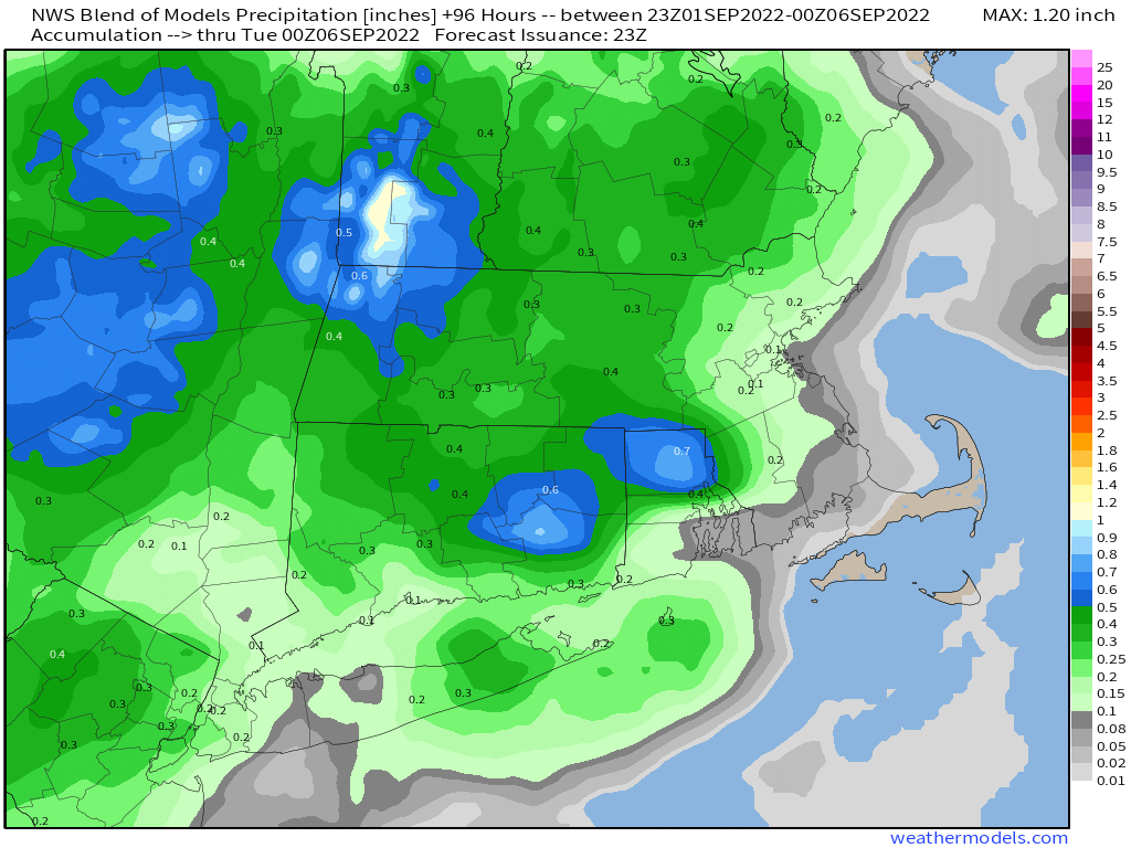
High pressure builds in for tonight and Friday with generally dry and cool conditions. Clear skies and light winds will allow for radiational cooling tonight, which may allow some of the normally cooler locations to drop into the 40s. As the high slides offshore on Saturday, temperatures and humidity levels will start to rise a little bit. Sunday looks even warmer and a bit more humid, but with a cold front approaching we may see some showers and thunderstorms during the afternoon and evening. A few more showers or storms are possible on Labor Day before the front pushes offshore and stalls out. We should not that some of the forecast models are painting a rather wet picture for late Sunday and Monday. We’re not buying that at the moment. Things could obviously change, and we’ll re-evaluate that when we issue our Weekly Outlook early Monday morning, but don’t go cancelling any Labor Day plans just yet.

Some models show the potential for heavy rain late Sunday and Labor Day. We’re not buying it. Sure, there will probably be some rain, but not the outrageous amounts other models show. Image provided by Weathermodels.com

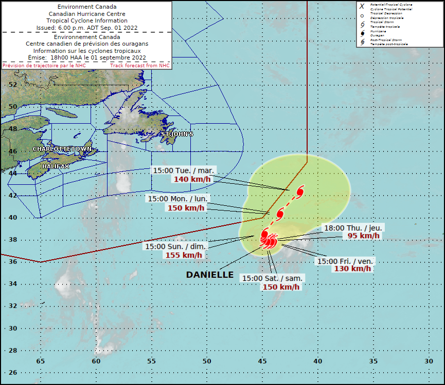
In other news, we have our first named “tropical” system in nearly two months, but it’s not exactly in the tropics. Tropical Storm Danielle is located about 950 miles west of the Azores, drifting toward the east at 2 mph. Maximum sustained winds are near 60, and the forecast calls for strengthening. Danielle could become the first hurricane of the year in the Atlantic on Friday. It is not a threat to any land areas.

Forecast track for Tropical Storm Danielle. Image provided by the Canadian Hurricane Centre.

Thursday night: Clear and cool. Low 48-55.

Friday: Plenty of sunshine. High 72-79. Offshore: Northeast 5-15 knots, seas 2-3 feet.

Friday night: Becoming partly cloudy. Low 53-60.

Saturday: A mix of sun and clouds. High 78-85. Offshore: East 5-10 knots, seas 2-3 feet.

Saturday night: Partly cloudy. Low 58-65.

Sunday: Partly sunny with some showers and thunderstorms possible late in the day, mainly north of the Mass Pike. High 81-88. Offshore: South 5-10 knots, seas 2 feet, visibility 1-3 miles in showers.

Sunday night: Mostly cloudy, chance for a few showers, mainly during the evening. Low 59-66.

Monday: More clouds than sun with a chance for a few showers. High 70-77. Offshore: East 5-10 knots, seas 2-3 feet, visibility 1-3 miles in showers.

Weekend Outlook: August 26-29, 2022

The final weekend of August is shaping up to be a rather nice one weather-wise.

High pressure slides offshore tonight, and a cold front moves toward the region on Friday. Some showers and thunderstorms are expected ahead of the front, and a few of them could be quite strong, but it does not look like a widespread severe outbreak. Some of the storms may produce gusty winds and heavy downpours, but we probably won’t see the amount of rain we had in some of the storms earlier this week. The front moves offshore Friday night, then high pressure builds in for the weekend with dry and seasonably warm conditions. We may start to warm up a bit on Monday along with seeing humidity levels start to rise again as the high slides offshore.

There is a slight risk for severe weather across parts of New England on Friday. Image provided by the Storm Prediction Center.

Thursday night: Partly cloudy. Low 63-70.

Friday: Early sun, then clouds move in with showers and thunderstorms developing during the late afternoon. High 84-91. Offshore: South winds 10-15 knots, gusts to 20 knots, seas 2-3 feet, visibility under 1 mile in morning fog, 1-3 miles in late-day showers and thunderstorms,

Friday night: Showers and storms end in the evening, followed by clearing. Low 62-69.

Saturday: Partly to mostly sunny, not as humid. High 77-84, cooler along the coast. Offshore: East winds 5-10 knots, seas 2-4 feet.

Saturday night: Partly cloudy. Low 59-66.

Sunday: Partly to mostly sunny. High 76-83. Offshore: Southwest winds 5-15 knots, seas 2-3 feet.

Sunday night: Partly cloudy. Low 60-67.

Monday: A mix of sun and clouds. High 83-90. Offshore: Southwest winds 5-15 knots, seas 2-3 feet.

Weekend Outlook: August 19-22, 2022

“When in drought, leave it out.” It’s an old phrase forecasters have used for quite a long time. What it means, is that when you’re in drought, rainfall will be tough to come by, so leave it out of the forecast. We found that out a few days ago when all of the models were forecasting a decent amount of rain for this area and we got little to none. Well, we’re not looking at much, if any, rainfall this weekend either.

Drought conditions continue to worse, and little relief is in sight. Image provided by the National Drought Mitigation Center.

Low pressure finally pulls away tonight and then skies start to clear out. High pressure builds in for Friday and into the weekend with dry and very warm conditions. As the high moves off to the east, humidity levels will creep up for Saturday and Sunday. Some clouds are expected on Saturday as a weak low pressure system passes well to the south. Clouds will stream back in on Monday as another frontal system moves in from the west. It could produce a few showers later Monday, but we wouldn’t count on it.

Little to no rainfall is expected across the region through late Monday. Image provided by Weathermodels.com

Thursday night: Becoming mostly clear. Low 59-66.

Friday: Sunshine and a few afternoon clouds. High 84-91. Offshore: Southwest winds 10-15 knots, seas 2-3 feet.

Friday night: Partly cloudy. Low 62-69.

Saturday: A mix of sun and clouds. High 85-92. Offshore: Southwest winds 5-10 knots, seas 1-3 feet.

Saturday night: Partly cloudy. Low 62-69.

Sunday: Partly sunny and humid. High 84-91. Offshore: Southeast winds 5-10 knots, seas 2-3 feet.

Sunday night: Becoming mostly cloudy. Low 61-68.

Monday: More clouds than sun, chance for a few showers and thunderstorms. High 77-84. Offshore: East to southeast winds 5-10 knots, seas 2-4 feet.

Weekend Outlook: August 12-15, 2022

We got rid of the heat a couple of days ago, the humidity will follow soon.

A cold front will approach the region tonight, with just a couple of showers accompanying the front when it moves through early Friday. After that, high pressure builds in for the weekend with temperatures at or below normal, and significantly lower humidity levels. An upper-level disturbance will move through on Saturday which may trigger a stray shower or two, but most of us will remain dry. Sunday looks like the best day of the week bunch with warm and dry conditions and a good amount of sunshine.

High temperatures will be mainly in the 70s on Saturday, which is roughly below normal for mid-August. Image provided by WeatherBell.

Monday is the transition day. Many of the models are showing the potential for some significant rainfall during the early to middle part of next week with an offshore low pressure system. Given recent trends and the ongoing drought, we are obviously skeptical that this will happen, but the models are in decent agreement for now. Assuming this trend continues, we’ll see clouds move in on Monday, with some showers possible by late in the day. We’ll obviously have more details and more confidence in what will happen when we publish our Weekly Outlook early Monday morning.

Some of the models show the potential for significant rainfall early next week. We’re highly skeptical that it will happen. Images provided by Pivotal Weather.

Thursday night: Partly to mostly cloudy, chance for a few showers, some patchy fog is possible, especially near the coast. Low 60-67.

Friday: A few lingering showers early, otherwise clouds and some sunshine, not as humid. High 75-82.

Friday night: Partly cloudy. Low 57-64.

Saturday: A mix of sun and clouds, slight chance for a shower. High 73-80.

Saturday night: Clear to partly cloudy. Low 56-63.

Sunday: Sunshine and some afternoon clouds. High 76-83.

Sunday night: Partly cloudy. Low 58-65.

Monday: Becoming mostly cloudy, showers may develop by late in the day. High 76-83.

Weekend Outlook: August 5-8, 2022

Heat and humidity are here, and there’s not going away for a while.

A Bermuda high pressure area will remain anchored off the East Coast for the next several days. It will continue to pump hot and humid air into the region. There will be some relief at times, but overall, we’ll stay hot and humid through at least Monday. A cold front will try to approach on Friday, and it will likely produce some showers and thunderstorms during the afternoon and evening. This will not only provide relief, but also help with our worsening drought. Unfortunately, we need a lot more rain, and this won’t do the trick. That front will essentially dissipate before moving through, so the heat will continue. A few showers and thunderstorms may pop up each afternoon this weekend, but they’ll be widely scattered, so most of us may not see one. Another front approaches on Monday, and this one may have a little more “oomph” to it. It may produce more showers and thunderstorms late in the day, but it likely doesn’t move through until Tuesday.

Friday’s thunderstorms could drop heavy downpours in spots, but coverage could be spotty. Images provided by Pivotal Weather.

Thursday night: Clear to partly cloudy. Low 69-76.

Friday: Early sun, then increasing clouds, showers and thunderstorms develop in the afternoon. High 89-96, cooler right at the coast. Offshore: Southwest winds 10-15 knots, seas 2-3 feet, visibility 1-3 miles in showers and thunderstorms.

Friday night: Partly to mostly cloudy, showers taper off in the evening. Low 67-74.

Saturday: Partly sunny, chance for an afternoon shower or thunderstorm. High 85-92. Offshore: Southwest winds 10-15 knots, gusts to 20 knots, seas 2-4 feet, visibility 1-3 miles in showers and thunderstorms.

Saturday night: Clear to partly cloudy. Low 69-76.

Sunday: Sunshine and some afternoon clouds, slight chance for a shower or thunderstorm. High 89-96, cooler right at the coast. Offshore: Southwest winds 10-20 knots, seas 2-4 feet.

Sunday night: Partly to mostly cloudy. Low 69-76.

Monday: Intervals of clouds and sun, showers and thunderstorms develop in the afternoon. High 86-93. Offshore: Southwest winds 10-15 knots, seas 2-4 feet, visibility 1-3 miles in showers and thunderstorms.

Weekend Outlook: July 29 – August 1, 2022

We really need some rain, and some of us will get a little, but not nearly enough, and for the most part, it shouldn’t impact your weekend plans.

Drought conditions are worsening across the region, and little improvement is expected for a while. Image provided by the National Drought Mitigation Center.

A few showers and thunderstorms are likely through this evening as a weak disturbance moves through, then skies may start to clear out a bit. Friday likely starts off with some sunshine, but a stronger front will be approaching. Another round of showers and thunderstorms is likely late Friday and into Friday night. Some models are showing the potential for the front to linger near the South Coast and keep the showers going through the night, but given the ongoing drought and recent trends, we’re not expecting a lot of rain, and it will likely be done before daybreak.

Some beneficial rain may fall in southern New Hampshire, but the rest of the region needs a lot more. Image provided by Weathermodels.com

High pressure builds in for the weekend and into Monday. This results in plenty of sunshine, warm temperatures, and fairly low dewpoints. In other words, nearly perfect weather for the end of July and start of August. There are some indications that heat and humidity will return next week, but we’ll worry about that in our Weekly Outlook early Monday.

Dewpoints will be in the 50s across much of the region Saturday afternoon. Image provided by WeatherBell.

Thursday night: Some showers or thunderstorms around in the evening, then becoming clear to partly cloudy. Low 64-71.

Friday: Morning sun, then clouds return with some showers and thunderstorms possible late in the day. High 84-91. Offshore: Southwest winds 10-15 knots, seas 2-3 feet, visibility 1-3 miles in late-day showers.

Friday night: Showers and thunderstorms during the evening, skies start to clear out late at night. Low 61-68.

Saturday: Plenty of sunshine. High 81-88. Offshore: West winds 5-10 knots, seas 2-4 feet.

Saturday night: Clear skies. Low 59-66.

Sunday: Sunshine and some afternoon clouds. High 82-89. Offshore: Southwest winds 10-15 knots, gusts to 20 knots, seas 2-3 feet.

Sunday night: Partly cloudy. Low 62-69.

Monday: Partly to mostly sunny. High 86-93. Offshore: Southwest winds 5-15 knots, seas 2-3 feet.

Weekend Outlook: July 22-25, 2022

Hot Hot Hot. Buster Poindexter’s song is also for the forecast for the next few days.

Showers and thunderstorms will end this evening as a frontal system pushes offshore, then skies clear out overnight. Drier air settles in for Friday and Saturday, with dewpoints in the 50s Friday and 60s Saturday, but it will remain hot, with temperatures well into the 90s in many locations. Sunday is shaping up to be a rather hot and humid day as another frontal system approaches the region. Temperatures should be well into the 90s again with high to oppressive humidity. Some models are showing the potential for triple-digit temperatures north and west of Boston, especially from the Merrimack Valley into southern New Hampshire. We’re not sure it gets quite that hot, but upper 90s are a distinct possibility. Some showers and thunderstorms are likely late Sunday night, and again on Monday as another frontal system crosses the region. Humidity levels will start dropping again later on Monday, but it will remain warm, with highs well into the 80s, and some places could top 90 once again.

Sunday is looking like a very hot day across much of the region. Image provided by WeatherBell.

If you’re curious about the record highs for Sunday and whether some could be broken, here are the current records for some selected cities across the region:

  • Blue Hill – 96 (1987)
  • Boston – 98 (1933)
  • Brockton – 97 (1987)
  • Concord, NH – 100 (1870)
  • Hyannis – 93 (1952)
  • Keene, NH – 95 (1910)
  • Lowell – 98 (1963 and 1987)
  • Manchester, NH – 95 (2001)
  • Nashua, NH – 100 (1952)
  • Newburyport – 96 (2002)
  • Portsmouth, NH – 95 (1987)
  • Providence, RI – 94 (1987)
  • Reading – 99 (2016)
  • Woonsocket, RI – 95 (2016)
  • Worcester – 94 (1910)

Thursday night: Showers and thunderstorms ending then skies clear out. Low 67-74.

Friday: Plenty of sunshine, not as humid. High 89-96, cooler right at the coast. Offshore: Small Craft Advisory for the South Coast. West winds 5-10 knots, becoming southwest 10-15 knots in the afternoon, seas 3-5 feet, a little higher off the South Coast, visibility under 1 mile in morning fog, improving in the afternoon.

Friday night: Clear skies. Low 66-73.

Saturday: Sunshine and a few clouds. High 89-96, cooler right at the coast. Offshore: Southwest 5-10 knots in the afternoon, seas 2-4 feet, visibility under 1 mile in morning fog, improving in the afternoon.

Saturday night: Clear to partly cloudy. Low 68-75.

Sunday: A mix of sun and clouds, humid. High 93-100. Offshore: Southwest winds 10-15 knots, gusting to 25 knots, seas 2-4 feet, visibility 10 miles or better.

Sunday night: Partly to mostly cloudy with some showers and thunderstorms possible. Low 70-77.

Monday: Intervals of clouds and sun with additional showers and thunderstorms, especially during the afternoon. High 84-91. Offshore: Small Craft Advisory likely. Southwest winds 10-20 knots, gusting to 25 knots, season 3-6 feet, visibility 1-3 miles in showers and thunderstorms.

Weekend Outlook: July 15-18, 2022

Despite a little rain early this morning, and some thunderstorms this afternoon, the drought continues to worsen around here, and we won’t get much relief over the next few days.

Parts of Northeastern Massachusetts and adjacent New Hampshire are now in a severe drought. Image provided by the National Drought Mitigation Center

We’ll have some showers and thunderstorms around this evening before a cold front pushes offshore. This allows drier air to settle in with high pressure for Friday and Saturday. Temperatures will remain on the warm side, but it won’t be humid. The humidity returns on Sunday as the high moves offshore and another frontal system approaches from the west. That front may trigger a few showers and thunderstorms late Sunday, but they likely hold off until Sunday night. Monday looks unsettled at this point as the front takes it’s time moving through, with more showers and thunderstorms likely. Some of the models are showing the potential for heavy rain at times on Monday, but given the way the models have performed in terms of rainfall, and the fact that we’re in a drought, we’re a bit skeptical on the idea of heavy rain for Monday. We’ll revisit that in our Weekly Outlook late Sunday night/early Monday morning.

Some models show the potential for heavy rain on Monday. We’re a bit skeptical. Images provided by Pivotal Weather.

Thursday night: Any lingering showers or thunderstorms end this evening, then skies clear out. Low 58-65.

Friday: Sunshine and a few clouds. High 79-86, coolest along the coast thanks to an afternoon seabreeze. Offshore: Northwest winds 5-10 knots becoming onshore in the afternoon, seas 2-4 feet, visibility under 1 mile in morning fog.

Friday night: Clear to partly cloudy. Low 59-66.

Saturday: A mix of sun and clouds. High 80-87. coolest along the coast. Offshore: South winds 5-10 knots, seas 2-3 feet, visibility 1-3 miles in some morning fog.

Saturday night: Partly cloudy. Low 63-70.

Sunday: Partly sunny, humid, chance for a late-day shower or thunderstorm. High 81-88. Offshore: Southwest winds 10-15 knots, gusts to 20 knots, seas 2-3 feet.

Sunday night: Partly to mostly cloudy with a few showers and thunderstorms around. Low 64-71.

Monday: Intervals of clouds and sunshine, with scattered showers and thunderstorms. High 81-88. Offshore: Southwest winds 10-15 knots, gusts to 25 knots, seas 2-4 feet, visibility 1-3 miles in showers.

Weekend Outlook: July 8-11, 2022

The weather for the upcoming weekend will be nearly perfect.

Sunshine will be dimmed by a few clouds today as high pressure slides offshore. Clouds will increase tonight as a warm front tries to approach the region. Humidity levels will increase tomorrow ahead of a cold front, but aside from a few hit-or-miss showers, the front will move through late in the day with little fanfare. After that, high pressure builds in for the weekend with sunshine, temperatures that are near or a little below normal for early July, and low humidity levels. Monday looks to be similar, but as the high moves offshore, temperatures and humidity levels will start to rise a little.

Dewpoints in the upper 40s and lower 50s in July? Enjoy the refreshing air this weekend! Image provided by WeatherBell.

Thursday night: Partly to mostly cloudy. Low 58-65.

Friday: Intervals of clouds and sunshine with a chance for a few showers. High 80-87. Offshore: South to southeast winds 5-10 knots, seas 2-3 feet.

Friday night: Becoming partly cloudy. Low 60-67.

Saturday: Sunshine and a few clouds. High 76-83, a little cooler along the coast. Offshore: Northeast to east winds 5-10 knots, seas 2-3 feet.

Saturday night: Clear skies. Low 53-60.

Sunday: Plenty of sunshine. High 75-82, a little cooler along the coast. Offshore: Southwest winds 10-15 knots, gusts to 25 knots, seas 2-4 feet.

Sunday night: Clear skies. Low 54-61.

Monday: Sunshine and some afternoon clouds. High 81-88. Offshore: South to southwest winds 10-15 knots, gusts to 20 knots, seas 2-4 feet.

Weekend Outlook: June 24-27, 2022

We’re entering the first weekend of astronomical summer and the weather is actually going to feel like….summer.

High pressure builds in tonight and remains in control through the weekend, with generally dry weather into Sunday. We could see a couple of stray showers Friday afternoon as a weak trough of low pressure at the upper levels of the atmosphere moves through, but they’ll be few and far between. Otherwise, we’re good through Sunday. Temperatures will gradually warm up, some locations likely reaching or exceeding 90 both Saturday and Sunday. While it will be quite warm, it shouldn’t be that humid, with dewpoints generally in the lower 60s. Clouds will start to move in later on Sunday as a cold front starts to approach from the northwest. That front will move though on Monday with some showers and thunderstorms. We really need the rain to help alleviate the developing drought, but we’re not sure how widespread Monday’s activity will be. A few days ago, the models were all showing the possibility for a decent slug of rainfall, but as is usually the case when we’re in a drought, as we get closer the models continue to back off. We’ll have more details on that in our Weekly Outlook early Monday morning.

Drought conditions continue to expand across southern New England. Image provided by the National Drought Mitigation Center.

Thursday night: Partly to mostly cloudy with areas of fog, some of it dense in spots. Low 53-60.

Friday: Becoming partly to mostly sunny. High 75-82, coolest along the coast. Offshore: Northeast to east winds 5-10 knots, seas 3-5 feet, visibility under 1 mile in morning fog, improving by afternoon.

Friday night: Clear skies. Low 56-63.

Saturday: Sunshine and a few clouds. High 84-91, a little cooler along the coast. Offshore: Variable winds becoming southwest 5-10 knots during the afternoon, seas 3-6 feet, visibility 10 miles or better.

Saturday night: Partly cloudy. Low 61-68.

Sunday: A mix of sun and clouds. High 86-93, a little cooler along the coast. Offshore: South to southwest winds 10-15 knots gusting to 20 knots, seas 2-4 feet, visibility 10 miles or better.

Sunday night: Partly cloudy during the evening, increasing clouds after midnight. Low 63-70.

Monday: Mostly cloudy with some showers and thunderstorms likely. High 73-80. Offshore: South to southwest winds 10-15 knots gusting to 20 knots, seas 3-5 feet, visibility 1-3 miles in showers and thunderstorms.