Weekly Outlook: January 25-31, 2021

This is shaping up to be one of those weeks that ages a meteorologist rapidly, since there are not only multiple systems to track, but the bust potential is much higher than normal.

The week starts off rather quietly, with high pressure moving offshore. We’ll still be on the chilly side, but close to normal for late January, and not as cold as the past few days were. Clouds will start streaming in as well, ahead of a storm system moving into the Midwest. This is the first headache of the week.

On average, high temperatures should be in the lower to middle 30s around here in late January. Image provided by Weathermodels.com

As that low pressure area moves into the Midwest, a secondary area of low pressure will develop near the Mid-Atlantic states, and will pass offshore to our south later Tuesday. However, some energy from the original system will still move towards us late Tuesday into Wednesday. The bulk of the precipitation from the secondary storm will stay to the south, with some snow showers or flurries possible along the South Coast, possibly as far north as the Mass Pike. What complicates things is the energy from the original storm. Some of the models have that move across the region with another area of snow, and possibly a decent amount. This has been a recent development in the models over the last 24 hours, which makes us skeptical, but many of the models show something similar, so we can’t completely ignore it. Right now, we’re thinking that a period of light snow is likely Tuesday night into early Wednesday, with some accumulations expected. There are some models that show significant accumulations in parts of the region. While that is possible, we don’t think it’s likely at the moment. If that were to change, we’d update the blog later Monday or Tuesday.

There is plenty of disagreement among the models about how much snow to expected between now and Wednesday afternoon. Images provided by Pivotal Weather.

That system pulls away on Wednesday and high pressure builds in. However, with the high building in north of us, we’ll stay chilly, but we’ll also have northeast winds. This may result in some ocean-effect snow in eastern parts of the area, especially Cape Cod, coastal Plymouth County, and Cape Ann. Some persistent snow showers could result in accumulations, possibly several inches, but this far in advance it’s too tough to predict if or where those bands may setup.

Ocean-effect snow is essentially the same as lake-effect snow. Image provided by NOAA.

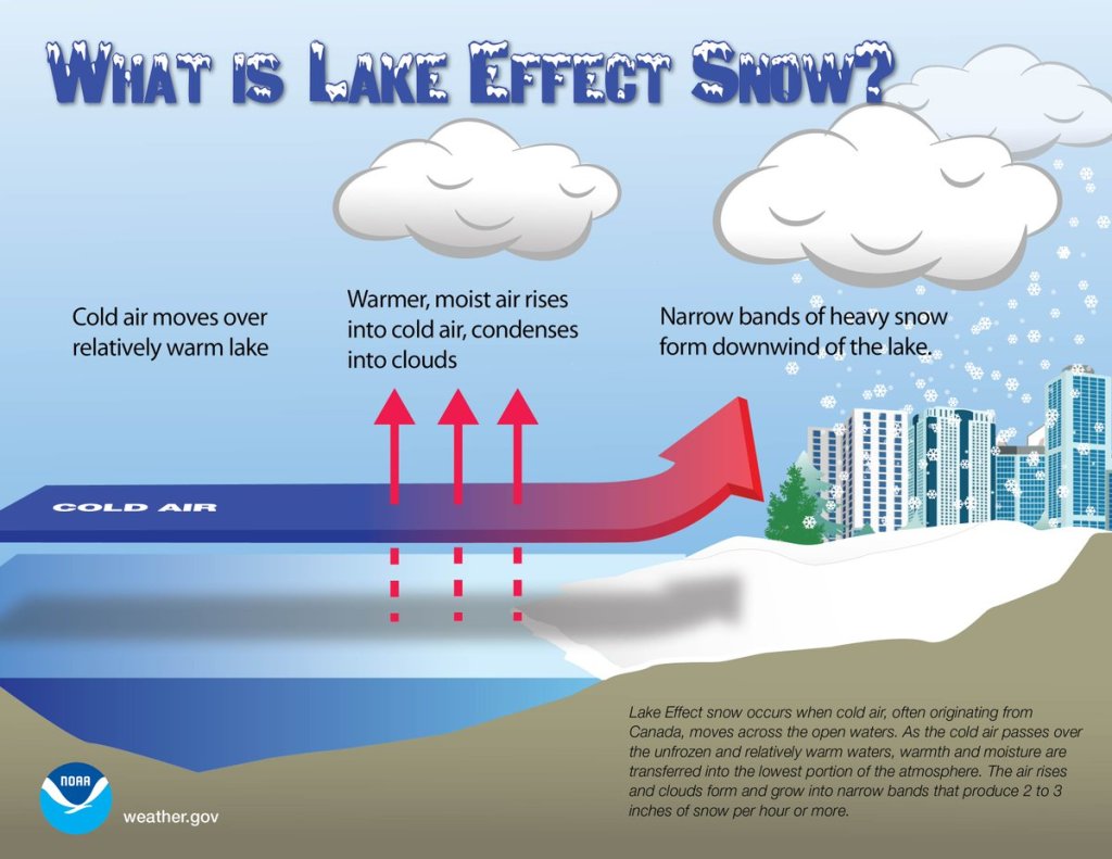
Another storm system will head towards the Mid-Atlantic by Thursday, and again, this storm should also pass far enough south to have little direct impact on us. However, unlike the system on Tuesday that will be weakening as it moves this way, this storm will strengthen. In fact, once it moves offshore, it should become a powerful storm over the North Atlantic. It may produce some gusty winds along the coast, especially Cape Cod, and possibly some additional ocean-effect snowfall, but the precipitation shield associated with the storm itself should remain offshore.

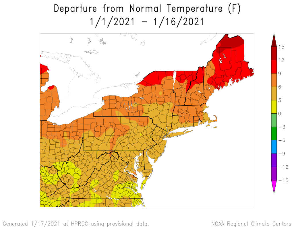
Behind that storm, much colder air will settle in for Friday and Saturday. We should finally start to clear out as high pressure builds in, though a few more ocean-effect snow showers are possible, especially across Cape Cod. The more noticeable impact is that it will be very chilly, likely colder than we just experienced this weekend. Daytime highs in the 20s (even some upper teens), and overnight lows in the teens and single-digits seem reasonable right now, with sub-zero wind chills, especially Friday into early Saturday.

Wind chills may be well below zero around here Saturday morning. Image provided by WeatherBell.

This brings us to Sunday, and our next headache. Yet another storm system will be heading for the Mid-Atlantic states, sending clouds our way. With high pressure over southern Quebec, we’ll still be on the cold side. The exact track this storm takes is still a big question mark, but this one doesn’t look like it’ll pass offshore to our south. In fact, several models bring the storm right across southern New England on Monday. We’re not going to get into too many details because it’s a week away, and technically outside the usual range of this forecast, but we’ll just let you know that there is the potential for a decent amount of snow early next week for parts of the region. It’s just potential for now and far from a lock, but the models have been showing this potential for several days now. We’ll get into more details on this one in our Weekend Outlook on Thursday.

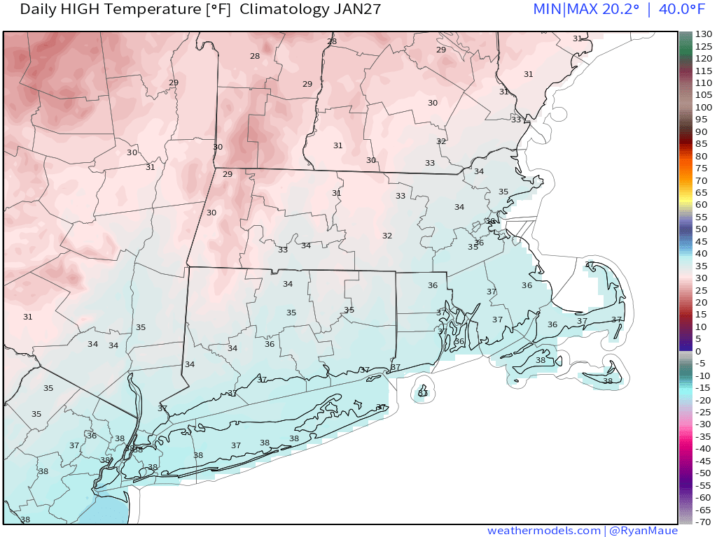
Monday: Sunny in the morning, clouds start to move in during the afternoon. High 30-37.

Monday night: Becoming partly to mostly cloudy. Low 17-24.

Tuesday: Cloudy, light snow may develop late in the day. High 29-36.

Tuesday night: Cloudy with light snow likely, possibly mixed with some rain along the south coast. Low 22-29.

Wednesday: Cloudy with light snow likely, mainly north and west of Boston, with snow or rain showers likely from Boston southward. High 32-39.

Thursday: Cloudy and breezy with a chance of snow showers, especially near the east coast. High 31-38.

Friday: Becoming partly to mostly sunny, breezy, and cold, though clouds may linger along the east coast with a few more snow showers possible. High 18-25.

Saturday: Mostly sunny and cold. High 19-26.

Sunday: Becoming mostly cloudy with a chance for snow at night. High 28-35.

Weekend Outlook: January 22-25, 2021

We’re more than halfway through meteorological winter, but for the first time in about a month, it’s actually going to feel like winter outside.

The disturbance that gave us snow showers and flurries today will push offshore tonight with some clearing, but it will be short-lived. Another system heading into the Great Lakes will send a warm front our way on Friday with clouds and somewhat milder conditions. As that system passes to our north Friday night, it will drag a strong cold front across the region. There may be a few snow showers along the front, but for the most part it will remain dry. What you will notice is gusty north to northwest winds behind the front bringing much colder air into the region for the weekend. Despite sunshine, temperatures may not reach freezing on Saturday. When you add in the gusty winds, wind chills will be in the single digits. Winds will remain gusty into the nighttime hours, when wind chills may drop below zero. The winds start to decrease on Sunday, but it will be another chilly day despite sunshine once again.

Wind chills will be near or below zero Sunday morning. Image provided by WeatherBell.

This brings us to Monday. We’re keeping an eye on a storm system that will be moving out of the Midwest and toward the East Coast. We’ll also have high pressure building in to the north so it will remain chilly. The question is, where does the low actually track? Right now, it looks like it should stay too far south to have much impact here, but that is far from definite at this point. If there are going to be any impacts, it would be mainly across southern parts of the area, and likely late Monday night into Tuesday, but again, there is still a lot that needs to be worked out. While most of the models are in pretty good agreement at this point that the storm stays south, we’ve seen plenty of times before (even earlier this winter), where the models agree on a storm missing out to the south 4-5 days in advance, and then they all shift northward a few days later. So, we’re not going to just write this off yet. Obviously, we’ll have a better idea when we get to our Weekly Outlook Monday morning.

Low pressure should stay to the south Monday night, but how far south? Images provided by Pivotal Weather.

Thursday night: Becoming clear to partly cloudy. Low 21-28.

Friday: Some morning sun, then clouds return. High 36-43.

Friday night: Partly to mostly cloudy through the evening with a slight chance for a snow shower, clearing and becoming breezy after midnight. Low 18-25.

Saturday: Sunshine and a few clouds, windy. High 23-30.

Saturday night: Clear and cold, still breezy. Low 10-17.

Sunday: Partly to mostly sunny and breezy. High 25-32.

Sunday night: Partly cloudy. Low 12-19.

Monday: Morning sunshine, clouds move in during the afternoon. High 30-37.

Weekly Outlook: January 18-24, 2021

We’ve had an extended stretch of relatively mild weather for January, but that’s about to change.

Temperatures have been well above normal across the Northeast for most of January thus far. Image provided by the Northeast Regional Climate Center.

Temperatures will remain mild compared to normal today, but we’ll have plenty of clouds once again as a weak upper-level disturbance moves across the region. It may produce a sprinkle or flurry in spots, but for the most part, we’ll remain dry. We’ll clear out tonight, then Tuesday will feature some sunshine and cooler temperatures as high pressure builds in. Some clouds will likely develop, because that’s just the way things have been this winter – we can’t seem to get a completely clear day, even when it looks like we should.

Even with high pressure building in, we’ll still have some clouds around Tuesday afternoon. Image provided by Weathermodels.com

Another weak disturbances moves through Tuesday night and early Wednesday with more clouds and possibly a few snow showers, but even colder air will start to filter in behind this system. Some clearing is possible Wednesday afternoon as the system moves away, but another quickly system follows for Thursday into Friday. This may produce some snow showers, but right now, we’re only expecting light accumulations, if that. That system will strengthen as it moves into Atlantic Canada, producing gusty northwest winds around here over the weekend as high pressure builds in, which will result in much cooler weather moving in. It does look like the colder weather will hang around through much of next week, so it will start to feel like winter once again.

Temperatures are expected to below normal across a large portion of the Northeast next week. Image provided by WeatherBell.

Monday: Some morning sun, then becoming mostly cloudy, chance for a sprinkle or a flurry, breezy. High 39-46.

Monday night: Clearing. Low 20-27.

Tuesday: A mix of sun and clouds. High 33-40.

Tuesday night: Partly to mostly cloudy with a few flurries possible. Low 22-29.

Wednesday: Plenty of clouds, maybe a few flurries in the morning and a few afternoon sunny breaks, breezy. High 29-36.

Thursday: Partly to mostly cloudy with scattered snow showers. High 28-35.

Friday: More clouds than sun. High 35-42.

Saturday: Partly to mostly sunny, windy, and colder. High 29-36.

Sunday: Sunshine and a few clouds, breezy. High 27-34.

Weekend Outlook: January 15-18, 2021

Our extended stretch of dry weather is nearing an end, with some rain on the way.

Most of the region has received less than 1 inch of liquid precipitation so far this month. Image provided by the Northeast Regional Climate Center.

The system that brought in some rain and snow showers earlier today is pulling away and we’ll have some clearing tonight. However, it won’t last too long, as clouds will stream back in on Friday ahead of low pressure moving into the Great Lakes. This is the same system that produced heavy rain and strong winds in the Pacific Northwest a few days ago, and strong winds across the Plains and Rockies last night and today. Around here, the biggest threat will be rainfall.

The system will move into the Midwest on Friday, sending a front well ahead of it towards the East Coast. A secondary area of low pressure will develop along the front in the Mid-Atlantic states and head northward along the front. This will bring rain into the region Friday night into Saturday, some of which could be heavy. We could see a little snow to start, especially across the higher elevations from central Massachusetts into southwestern New Hampshire, but temperatures should be mild, especially on Saturday as a warm front moves through. How far north the warm front gets is still a bit of a question, but it looks like most of our area should get into the mild air, with temperatures well into the 40s Saturday morning and early afternoon, possibly topping 50 in spots. While it will still be breezy, especially along the South Coast behind the warm front, the strongest winds will likely be on Sunday, behind a cold front.

Saturday’s system could produce a decent amount of rain around here. Image provided by weathermodels.com

The rain ends Saturday afternoon with the passage of that cold front, but skies probably won’t completely clear. High pressure will try to build in at the surface, but an upper-level low pressure system will make its way eastward, crossing our area later Sunday into Monday. This will keep plenty of clouds around, but with drier air moving in, only a few rain or snow showers are possible, mainly on Monday.

Thursday night: Becoming partly cloudy. Low 24-31.

Friday: Some morning sun, then clouds return. High 37-44.

Friday night: Cloudy and becoming breezy with showers developing, possibly some wet snow from the hills of Worcester County into the Monadnocks of southwestern New Hampshire. Low 30-37 during the evening, then temperatures rise after midnight.

Saturday: Cloudy and windy in the morning with rain likely, possibly heavy at times, ending in the afternoon, possibly followed by some late-day clearing. High 44-51.

Saturday night: Becoming partly cloudy and breezy. Low 27-34.

Sunday: Partly sunny and breezy. High 37-44.

Sunday night: Partly cloudy. Low 23-30.

Monday: Intervals of sun and clouds, still breezy, slight chance for a sprinkle or a flurry. High 34-41.

Weekly Outlook: January 11-17, 2021

Another fairly quiet week is coming up across the region, but don’t expect the dry spell to last too much longer.

We start the week on a chilly note with high pressure sliding offshore. A weak disturbance will spread some clouds in, but little precipitation will accompany it. The middle of the week will feature high pressure at the surface, but with some additional upper-level disturbances swinging through, we’ll have periods of clouds at times, but little to no precipitation, and temperatures that are near to above normal for the middle of January.

Average high temperatures for mid-January are in the middle to upper 30s. Image provided by Weathermodels.com

By Friday, we’ll start to see some changes as a fairly strong low pressure system moves into the Great Lakes. That will keep us on the mild side of it, with some rain possible during Friday and Saturday before a cold front finally pushes through. It won’t be raining the entire time, but it does appear as though our extended stretch of dry weather will finally end. How much rain we’ll get is still up for debate, as the models aren’t all on the same page at the moment. Cooler air settles in behind that front on Sunday.

Some models bring a decent amount of rain in for Friday and Saturday, some have very little. We’ll see which way they trend over the next few days. Images provided by Pivotal Weather.

Monday: Partly to mostly cloudy. High 34-41.

Monday night: Clearing. Low 20-27.

Tuesday: A mix of sun and clouds. High 35-42.

Tuesday night: Variably cloudy. Low 20-27.

Wednesday: Partly sunny. High 36-43.

Thursday: Intervals of clouds and sunshine. High 40-47.

Friday: Mostly cloudy with some showers possible late in the day and at night. High 43-50.

Saturday: More clouds than sun, chance for a few showers, mainly in the morning. High 40-47.

Sunday: Becoming partly to mostly sunny, breezy, and cooler. High 33-40.

Weekend Outlook: January 8-11, 2021

We’ve got a very quiet weather pattern across the region for the next several days.

High pressure is providing us plenty of sunshine afternoon. Loop provided by the College of DuPage.

A chilly night is expected tonight with high pressure in control. Clear skies and light winds will allow for some radiational cooling, with some places dropping into the teens. Friday features sunshine, but a weak cold front will move through. It will have little moisture associated with it, so aside from a few snow showers in northern New England, you won’t really notice it. For Saturday, a storm system will pass well to the south, sending some clouds our way, but little else, as it will be too far south to have any other impacts. High pressure then returns for Sunday and Monday with dry and seasonably cool conditions.

Tranquil weather is expected through the weekend. Loop provided by WeatherBell.

Thursday night: Clear skies. Low 17-24.

Friday: Plenty of sunshine. High 33-40.

Friday night: Clear to partly cloudy. Low 18-25.

Saturday: A mix of sun and clouds. High 30-37.

Saturday night: Partly cloudy. Low 19-26.

Sunday: Partly sunny. High 31-38.

Sunday night: Partly cloudy. Low 16-23.

Monday: Sunshine and some afternoon clouds. High 33-40.

Weekly Outlook: January 4-10, 2021

We’ve got a fairly quiet week coming up, but that doesn’t mean sunshine and mild weather the entire time.

The storm system that brought us some rain and snow yesterday and last night will slowly pull away from the region today, but we’ll still have plenty of clouds, and maybe a few more showers, mainly across southeastern Massachusetts and Cape Cod. By Tuesday, the storm will stall out near Atlantic Canada, but the flow around it may help produce a few ocean-effect rain or snow showers, especially across eastern parts of the region. By Wednesday, the system pulls away and high pressure builds in with dry and seasonably cool conditions into Friday.

Normal high temperatures for early January are in the middle to upper 30s around here. Image provided by Weathermodels.com

By Friday night, low pressure will be moving off the North Carolina coastline and headed off toward the northeast. Right now, it looks like this system will pass too far to the south and east to have any impact on us, except possibly Cape Cod and southeastern Massachusetts, but it’s still 5 days away and things can change, so we’ll keep an eye on it. Once that system pulls away on Saturday, high pressure builds back in for next weekend.

For now, the models are in agreement that a storm stays well to our south Friday night. Images provided by Pivotal Weather.

Monday: Plenty of clouds, some showers are possible across southeastern Massachusetts and Cape Cod, mainly in the morning, a few sunny breaks are possible well inland during the afternoon. High 35-42.

Monday night: Partly to mostly cloudy, a few rain or snow showers are possible in eastern areas. Low 24-31.

Tuesday: Mostly cloudy, chance for a few more rain or snow showers in eastern areas. High 32-39.

Tuesday night: Partly to mostly cloudy. Low 25-32.

Wednesday: Becoming partly to mostly sunny. High 33-40.

Thursday: Lots of sunshine. High 36-43.

Friday: Sunshine dimmed by increasing afternoon high clouds. High 33-40.

Saturday: Clouds early, skies start to clear out in the afternoon. High 31-38.

Sunday: Mostly sunny. High 32-39.

New Year’s Weekend Outlook: December 31, 2020 – January 4, 2021

As we get into the final days of the year and start of a new year, we’ve got a fairly complex weather pattern shaping up across the region.

A warm front will move across the region tonight, but little precipitation will accompany it. What you will notice is that temperatures will bottom out this evening, then rise as we head through the overnight hours. Low pressure will move into the St. Lawrence Valley early on Thursday, dragging a cold front across the region during the morning. Some showers will accompany that front, but they’ll be gone by midday. High pressure then builds in, allowing skies to clear out in the evening. So, if you have any New Year’s Eve plans, weather won’t be an issue, though it will be on the cold side, as you’d expect at the end of December.

Temperatures should be in the middle to upper 20s under clear to partly cloudy skies at midnight Thursday night. Image provided by WeatherBell.

New Year’s Day starts off sunny and chilly, but clouds stream back in during the afternoon ahead of low pressure moving into the Great Lakes. We’ll see precipitation moving in towards midnight, but with cold air in place, things will be tricky. Along the coast, we’re looking at just a chilly rain, but across interior sections, it’ll be a different story. We’ll likely see it start off as snow, with some minor accumulations (an inch or two), especially from the Merrimack Valley and central Massachusetts into southern New Hampshire.

A little snow may accumulate early Saturday morning across the region, Image provided by WeatherBell.

Eventually, a change to sleet and freezing rain is expected across the interior as milder air moves in aloft. Milder air will also move in at the surface, so precipitation should change over to plain rain everywhere by Saturday morning, but before that happens, a period of freezing rain could result in some slippery travel across the interior before daybreak Saturday. The rain ends by midday, then we’ll see some clearing by late afternoon. This will also be short-lived.

The GFS model shows the progression of the Friday night storm. Loop provided by the College of DuPage.

Clouds come back in on Sunday as a storm system starts to move up the East Coast. There is still plenty of uncertainty with the track of this system, but a period snow or rain is looking likely for late Sunday into early Monday, especially across southeastern Massachusetts. We should have more clarity on this system once the Friday night system moves past the region.

There are discrepancies among the models in regards to our Sunday night storm. Images provided by Pivotal Weather.

Wednesday night: Cloudy and breezy with showers developing after midnight. Low 31-38 during the evening, temperatures rise overnight.

Thursday: Showers ending in the morning, some clearing develops late in the day. High 41-48.

New Year’s Eve: Becoming clear to partly cloudy. Low 19-26.

New Year’s Day: Sunny in the morning, clouds return in the afternoon. High 34-41.

Friday night: Cloudy with rain developing after midnight across the South Coast. Inland, snow will develop, changing to sleet, freezing rain, and eventually plain rain from south to north. Low 28-35 during the evening, temperatures rise overnight.

Saturday: Any remaining wintry mix across the interior changes to plain rain early, ending by midday. Some sunny breaks develop in the afternoon. High 35-42 north and west of I-495, 43-50 elsewhere.

Sunday night: Partly cloudy. Low 25-32.

Sunday: Cloudy with rain or snow possible late in the day. High 36-43.

Sunday night: Cloudy with a chance of rain or snow. Low 27-34.

Monday: Rain or snow ending in the morning, some clearing late in the day. High 35-42.

Weekly Outlook: December 28, 2020 – January 3, 2021

We’ve reached the final days of 2020, but there may still be a little mayhem on the horizon.

We start the week out on a rather mild note. Low pressure will head up the St. Lawrence Valley today, bringing in some clouds but also milder weather. There could be a shower or two, but the bulk of the precipitation associated with this storm will stay to our north and west. The storm drags a cold front across the region at night, putting an end to our brief mild spell. Breezy and colder conditions settle in for Tuesday as high pressure starts to build back in. Wednesday also looks to be on the cold side, but should be less windy, so it won’t feel as cold.

Temperatures could reach 50 in parts of the region this afternoon. Image provided by Weathermodels.com

This brings us to the final day of a year that most of us are all too happy to see end. Another low pressure area passes to our north and west, with milder conditions once again and some rain showers, though it does look like it should be dry for midnight if you are planning to be out and about. However, the cold front trailing that system will likely stall out near or just south of the region while high pressure tries to build in from the north early on New Year’s Day. Another low pressure area will start heading toward the Midwest that day as well. The front to our south will try to head back northward as a warm front, but with high pressure to the north, cold air may remain in place at the surface, especially across the interior. As the precipitation starts to move in, we may have warm air aloft and cold air at the surface, which would be a recipe for freezing rain. Obviously, being this far out, things will likely change, but we could be looking at icing, possibly some significant icing, across the interior. This system will take it’s time moving toward the region, so even though the warmer air should eventually win out and change everything to plain rain, the rain may continue into Saturday before winding down. High pressure builds in on Sunday with drier and cooler weather. We should have some additional clarity on this situation later this week in our Weekend Outlook, which may be published on Wednesday again.

The models don’t agree on what type of precipitation we’ll have on Friday, or whether we’ll have any at all. Images provided by Pivotal Weather.

Monday: Plenty of clouds, breezy, just a slight chance for a shower. High 43-50.

Monday night: Clearing. Low 24-31.

Tuesday: Sunny in the morning, some clouds around during the afternoon, breezy. High 29-36.

Tuesday night: Clear and chilly. Low 14-21, though some of the normally colder locations could drop into the single digits.

Wednesday: More clouds than sunshine. High 33-40.

New Year’s Eve: Cloudy and breezy with showers likely during the afternoon and evening. High 44-51.

New Year’s Day: Cloudy with a chance for rain near the coast, but a wintry mix of snow, sleet, or freezing rain is possible inland. Precipitation should gradually change to rain inland as we head through the overnight hours. High 38-45.

Saturday: Mostly cloudy with more showers possible. High 43-50.

Sunday: Partly to mostly sunny. High 34-41.

Christmas Weekend Outlook: December 24-28, 2020

We’ve got a couple of busy days coming up, and not just because it’s Christmas.

Low pressure is moving across Iowa this afternoon, producing blizzard conditions across parts of the Upper Midwest and Northern Plains. That system will impact us over the next few days, but in a different way. As it moves toward the Great Lakes, it will start to send milder air into the region tonight, but more noticeably tomorrow. Southerly winds will gradually increase tomorrow, becoming quite strong tomorrow night and into Christmas morning. Sustained winds of 15-30 mph are likely, with wind gusts to 50-60 mph or more possible. This could result in power outages, so don’t be surprised if you wake up Christmas morning and can’t charge up those new electronics you found under the tree.

Damaging wind gusts are possible across much of the region Thursday night and Christmas morning. Image provided by WeatherBell.

Wind isn’t the only issue we’ll have. Rain will move in Thursday night, and continue into Christmas Day. While it may not be raining the entire time, there will be some bands of heavy rain, with rainfall totals in excess of an inch possible in many areas. The rain, combined with temperatures climbing above 50, will help to melt a lot of the snow that is on the ground. This could result in some flooding issues in some spots, but widespread flooding doesn’t look likely.

The ECMWF shows how our snow cover could quickly disappear over the next few days. Loop provided by Weathermodels.com

As this storm system moves into southeastern Canada, it will drag a strong cold front across the region on Christmas Day. Although the day will start mild, likely in the 50s for most of us, temperatures will drop during the afternoon. If the cold air moves in fast enough and the precipitation is slower to move out, we could even see some wet snowflakes before everything winds down late in the day. At night, temperatures will continue to drop, meaning that the wet roads will likely start to ice over if they are not treated, as they won’t have had much time to dry before the cold air moves in.

The GFS model shows the warmer air move in on Christmas Eve, then quickly get replaced on Christmas Day. Loop provided by WeatherBell.

High pressure builds in for the weekend with dry and seasonably cold conditions. It may still be a bit breezy on Saturday, adding to the chill, but Sunday may also be a few degrees milder. By Monday, we’ll be watching another storm system passing to our west, with some showers possible.

Wednesday night: Becoming partly to mostly cloudy. Low 23-30 this evening, but temperatures may start to rise a bit after midnight.

Christmas Eve: Mostly cloudy, becoming breezy in the afternoon. High 48-55.

Thursday night: Cloudy and windy with showers developing, becoming steady rain late at night. Temperatures gradually rise overnight.

Christmas Day: Cloudy with rain likely, possibly heavy at times, windy in the morning. High 53-60 in the morning, temperatures drop during the afternoon.

Friday night: Mostly cloudy and breezy with any lingering showers ending in the evening, possibly mixed with a few wet snowflakes, some clearing is possible late at night. Low 22-29.

Saturday: Becoming partly to mostly sunny. High 28-35 (welcome back to December).

Saturday night: Clear skies. Low 19-26.

Sunday: Partly to mostly sunny. High 32-39.

Sunday night: Increasing clouds. Low 22-29.

Monday: Mostly cloudy and breezy with a few showers possible. High 42-49.