We’ve got another week that starts out with some rain, but shouldn’t end that way.
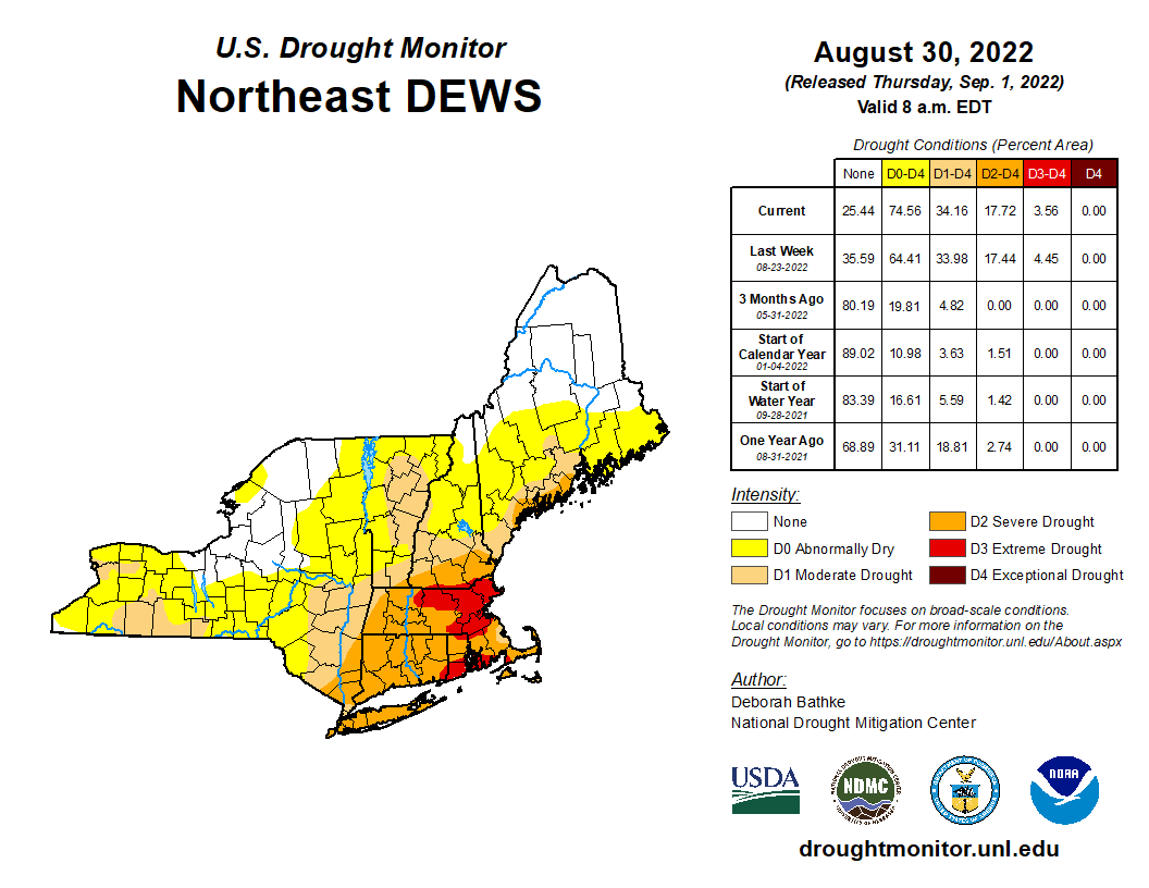
Last week’s heavy rain helped, but we remain in in severe to extreme drought. Image provided by the National Drought Mitigation Center.
We start off with a few showers this morning as a warm front moves through, but once they end we’ll see some sunshine today with warm and humid conditions. Clouds return tonight as a cold front approaches, and that front will produce some showers and thunderstorms as it moves through on Tuesday. A few storms may produce some gusty winds and heavy downpours, but for the most part, this should be a light rainfall event for the region. Behind the front, high pressure starts to build in on Wednesday, but temperatures will remain on the mild side. A stronger push of colder air moves in Wednesday night, leading to below normal temperatures for Thursday through Saturday. Temperatures may fail to reach 70 for highs in parts of the region, especially Thursday and Friday. By Sunday, the high moves off the east, allowing temperatures to moderate across the region.
Tuesday’s rain will be beneficial, but we need a lot more. Image provided by WeatherBell.
Monday: Intervals of clouds and sun, a few showers likely, mainly in the morning. High 77-84.
We’ve got a fantastic late summer/early fall weekend coming up across the region.
The forecast for the next several days is actually fairly simple. High pressure will build into the region, and slowly drift eastward over the next several days. The result is sunshine each afternoon through Sunday, with temperatures gradually warming. Some of the smoke from the wildfires out West may reach our skies this weekend, resulting in hazy conditions at times. Some clouds will start to filter in on Sunday and Monday as the next low pressure system approaches the region. Some showers are possible on Monday, but it looks like most of the activity should hold off until Monday night or Tuesday.
Some of the models have rain move in on Monday, several others keep it dry. We’re leaning toward the drier ones for now. Images provided by Pivotal Weather.
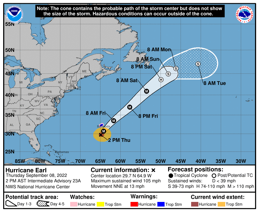
One other thing to keep in mind – Hurricane Earl will pass well south and east over the region over the next few days, but it will brush Bermuda. It will have one impact around here though – it will churn up some rough seas which will impact our coastal waters and beaches through the weekend. If you’re planning to head to the beach, there will be a high risk for rip currents, so use some caution. Offshore, small craft advisories are up for the coastal waters south and east of the Cape and Islands.
Forecast track for Hurricane Earl. Image provided by the National Hurricane Center.
Thursday night: Partly cloudy. Low 51-58.
Friday: Early clouds, then becoming mostly sunny and hazy at times. High 74-81.
Friday night: Clear skies. Low 53-60.
Saturday: Hazy sunshine. High 79-86.
Sunday night: Partly cloudy. Low 58-65.
Sunday: Partly sunny, hazy. High 79-86.
Sunday night: Partly to mostly cloudy. Low 59-66.
Monday: Intervals of clouds and sun, chance for a shower. High 74-81.
Some much-needed rain is on the way, but unfortunately much of it will fall on a holiday.
Despite last week’s rain, much of the region remains in severe or extreme drought. Image provided by the National Drought Mitigation Center.
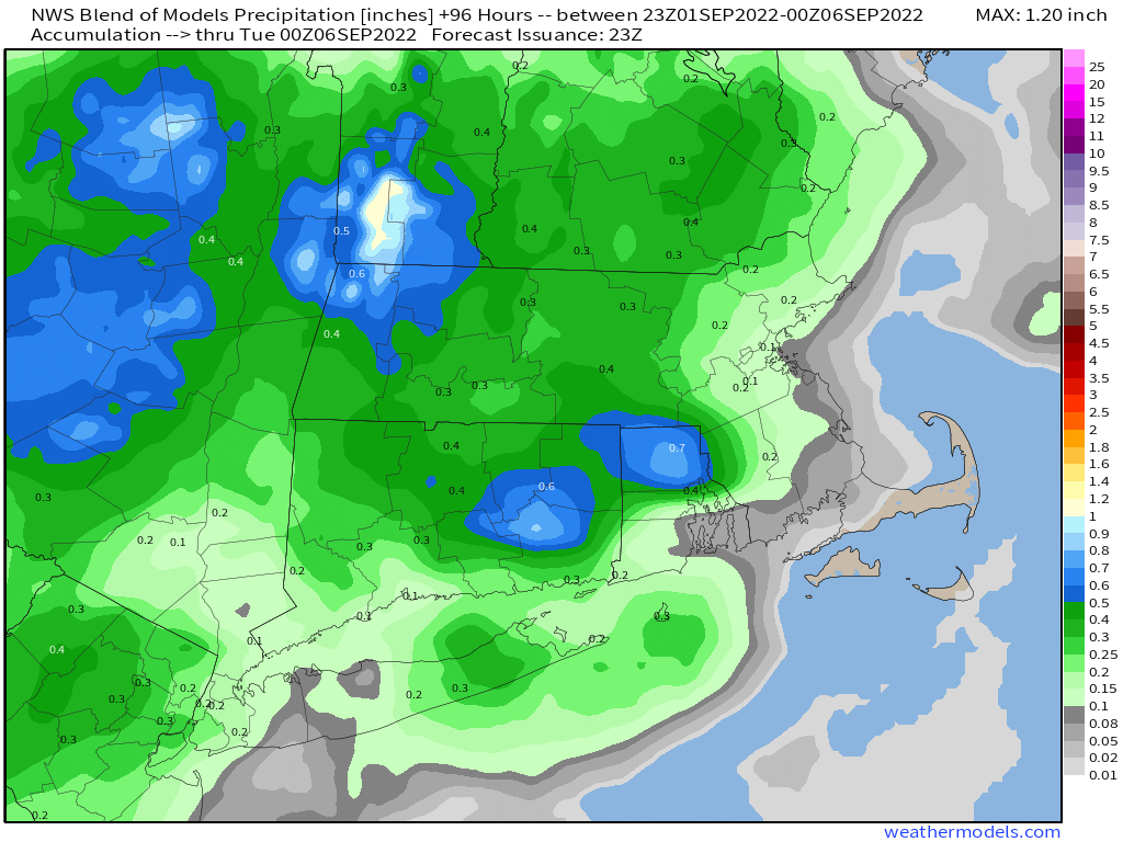
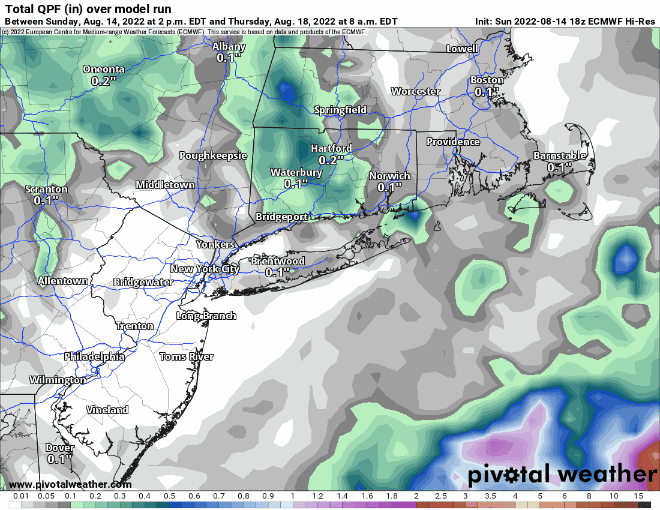
We start the week off with a cold front stalling out across the region. North of the front we’ll have some showers today with temperatures likely staying in the 60s. Closer to the South Coast, temperatures may be in the 70s with less rain at first, but still plenty of clouds. A wave of low pressure will ride along the front, bringing some additional showers or a period of steady rain in late today and tonight. By Tuesday, the front starts to push off to the south, and the shower activity winds down during the afternoon. How much rain we’ll see is still a bit of question, even as it has already started across parts of the area. Some models are still showing the potential for 3-6 inches of rain (or more) across the region, while others show less. Either way, we need all the rain we can get to help put a dent into the ongoing drought and to help refill the rivers, lakes, ponds, and reservoirs across the region. With most places likely to see at least a period of heavy rain, Flood Watches have been issued for much of the region through later Tuesday.
Some models show the potential for very heavy rain across the region today and tomorrow. Images provided by Pivotal Weather.
Skies start to clear out Tuesday night, then high pressure builds in for Wednesday right into the weekend, with a return to dry weather. After a couple of chilly day Monday and Tuesday, temperatures will return to near to above normal levels for the rest of the week and the weekend, with many days featuring highs getting back into the 80s across parts of the area once again.
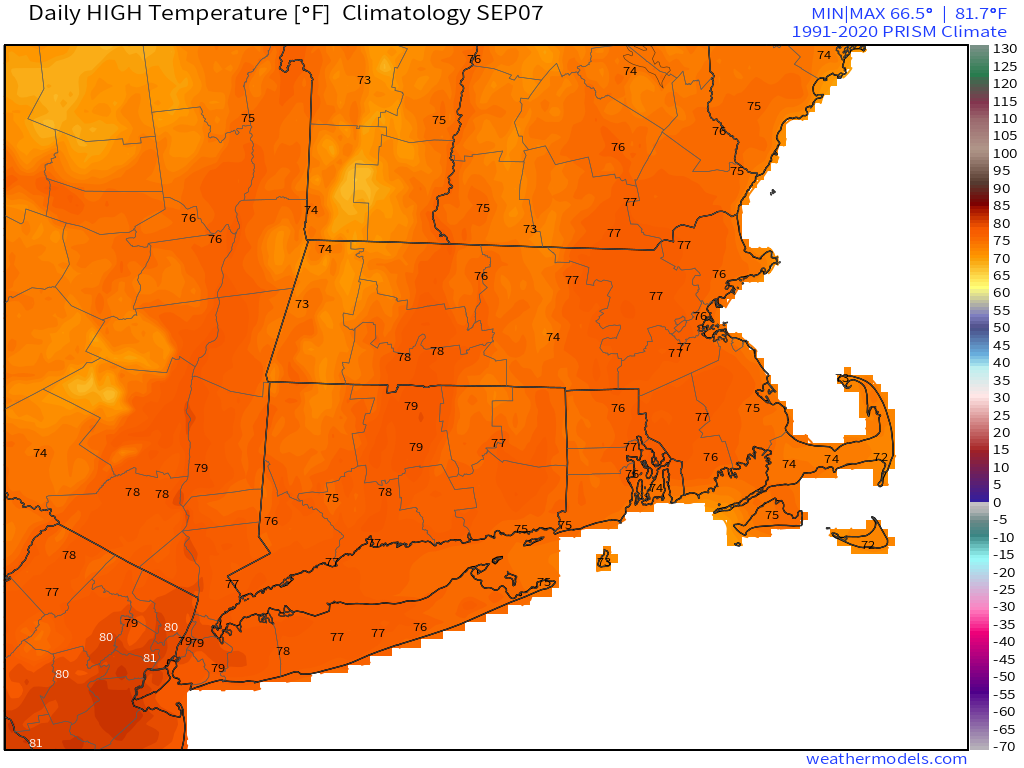
Normal high temperatures for early September are in the middle to upper 70s across the region. Image provided by Weathermodels.com
Monday: Occasional showers. High 64-71 north of the Mass Pike, 71-78 south of the Pike.
Monday night: Periods of rain and showers, some of the rain could be heavy. Low 57-64.
Tuesday: Cloudy and cool with showers gradually ending during the afternoon. High 62-69.
Tuesday night: Overcast with a few lingering showers during the evening, then some late night clearing may develop. Low 53-60.
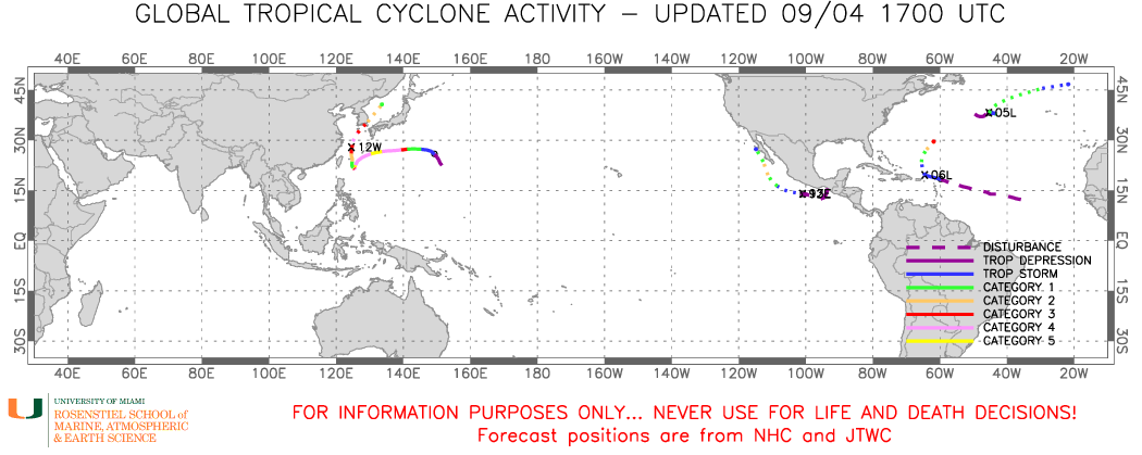
There was very little tropical activity around the world during July and August, but as the calendar has flipped to September and we approach the peak of Hurricane Season (especially in the Atlantic), several storms have developed.
There are now 4 active tropical cyclones around the world. Image provided by Brian McNoldy, University of Miami, Rosenstiel School.
The storm that is the biggest threat to land is actually in the Western Pacific Ocean. Typhoon Hinnamnor is centered about 210 miles west-northwest of Okinawa, Japan, moving toward the north at 9 mph. Maximum sustained winds are near 120 mph. A little additional strengthening is possible today before a weakening trend begins. The forecast for Hinnamnor is for gradual weakening as it moves northeastward over the next 24 hours. The center will pass close to or across southeastern portions of South Korea on Monday as a typhoon, with top winds still in the 100-110 mph range. Storm surge will likely be confined to just a small portion of the South Korean coastline, but that area includes the city of Busan, the 2nd most populous city in South Korea. Busan is also the 6th busiest port in the world. Heavy rain and gusty winds are likely across much of the Korean Peninsula, but also could impact parts of eastern China (near Shanghai) today, and parts of Japan over the next few days.
Forecast track for Typhoon Hinnamnor. Image provided by the Korean Meteorological Administration.
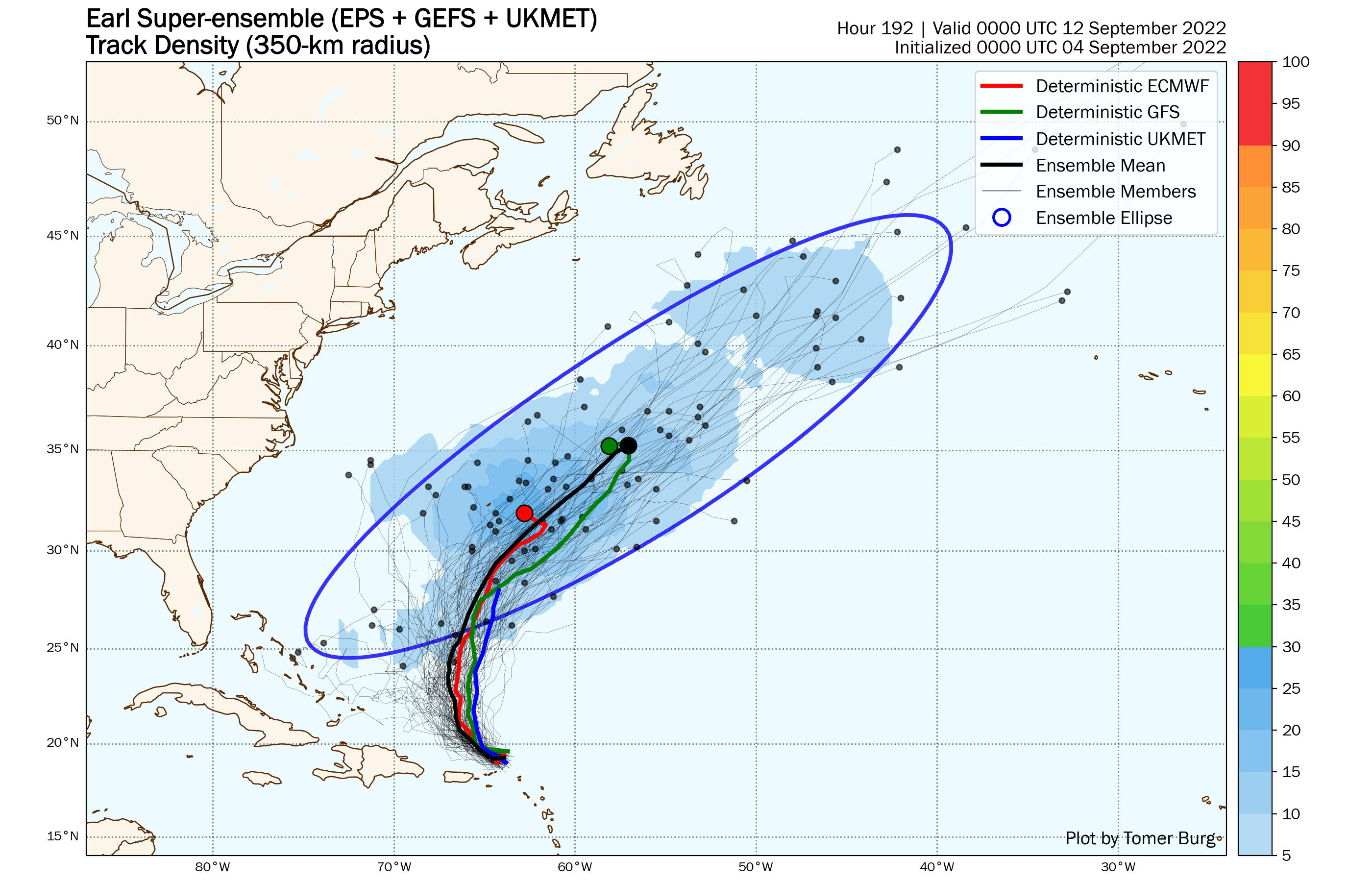
In the Atlantic, after going nearly two months without a named system, we now have twostorms to track. Tropical Storm Earl developed Saturday night east of the Lesser Antilles. As of midday Sunday, Earl was centered about 85 miles north-northeast of St. Thomas, USVI, moving toward the northwest at 3 mph. Maximum sustained winds are near 50 mph. Earl is bringing some gusty winds and heavy downpours to parts of Puerto Rico, the Virgin Islands, and northern Leeward Islands today and will continue to do so into Monday as it drifts toward the northwest and eventually north. The forecast for Earl calls for a turn more toward the north on Monday, with gradual strengthening expected. Earl is expected to become a hurricane by Tuesday and could become a rather potent storm by mid-to-late week. The official forecast from the National Hurricane Center calls for Earl to eventually turn more toward the northeast, heading out over open water southeast of Bermuda. However, as is usually the case with tropical systems, this is hardly a lock. An upper-level trough of low pressure moving into the central Atlantic is expected to help turn Earl toward the northeast and out to sea. If that trough moves a little faster, Earl may not make the northeast turn, at which point, the track becomes highly uncertain. Another trough of low pressure will be moving toward the East Coast while a ridge of high pressure settles in across the western Atlantic. This could increase the threat to Bermuda before the next trough moves in and kicks Earl out to sea. If you’re wondering about whether Earl could threat the East Coast, it is highly unlikely at this point, but the odds are not zero. A few members of the various Ensemble forecasts do show a significantly more westward track to Earl, but the vast majority still show a track out to sea (or near Bermuda then out to sea).
Most of the various ensemble members show an out to sea track for Earl, but there are a few that threat Bermuda. Iage provided by Tomer Burg.
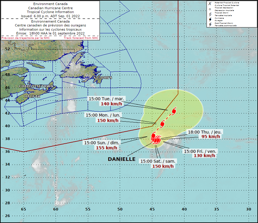
Out in the North Atlantic, Hurricane Danielle, the first hurricane of the season in the Atlantic, is strengthening this afternoon. As of midday, Danielle had maximum sustained winds near 80 mph and was centered nearly 1000 miles west of the Azores. Danielle is nearly stationary right now, but it is expected to start moving toward the northeast and then east over the next few days. Some additional strengthening is possible tonight and Monday, but after that it will start moving over cooler water, and a gradual weakening trend will begin. Danielle is expected to become extratropical later this week, and could bring heavy rain and gusty winds to parts of the British Isles as a strong extratropical system toward the end of the week.
Satellite loop of Hurricane Danielle. Loop provided by NOAA.
Finally, Tropical Depression 12-E has developed off the southwest coast of Mexico. As of midday, it was centered about 225 miles south-southwest of Acapulco, moving toward the west at 10 mph. Maximum sustained winds are near 35 mph. The forecast calls for steady strengthening, and the system could become a tropical storm later today or tonight, and a hurricane early this week. A turn more toward the northwest is expected early this week, and the system could threaten parts of the Baja Peninsula toward the latter half of the week. By the end of the week, the system, or what’s left of it, could bring some heavy rainfall into parts of the Southwest and Southern California, enhancing what has already been a very active monsoon season.
Model forecasts for the track of Tropical Depression 12-E. Image provided by WeatherBell.
With the climatological peak of hurricane season in the Atlantic about a week away, and the peak of the Eastern Pacific season encompassing most of September, additional storms are likely to form over the next few weeks.
Labor Day Weekend starts off with some fantastic early September weather, but it may not end that way.
High pressure builds in for tonight and Friday with generally dry and cool conditions. Clear skies and light winds will allow for radiational cooling tonight, which may allow some of the normally cooler locations to drop into the 40s. As the high slides offshore on Saturday, temperatures and humidity levels will start to rise a little bit. Sunday looks even warmer and a bit more humid, but with a cold front approaching we may see some showers and thunderstorms during the afternoon and evening. A few more showers or storms are possible on Labor Day before the front pushes offshore and stalls out. We should not that some of the forecast models are painting a rather wet picture for late Sunday and Monday. We’re not buying that at the moment. Things could obviously change, and we’ll re-evaluate that when we issue our Weekly Outlook early Monday morning, but don’t go cancelling any Labor Day plans just yet.
Some models show the potential for heavy rain late Sunday and Labor Day. We’re not buying it. Sure, there will probably be some rain, but not the outrageous amounts other models show. Image provided by Weathermodels.com
In other news, we have our first named “tropical” system in nearly two months, but it’s not exactly in the tropics. Tropical Storm Danielle is located about 950 miles west of the Azores, drifting toward the east at 2 mph. Maximum sustained winds are near 60, and the forecast calls for strengthening. Danielle could become the first hurricane of the year in the Atlantic on Friday. It is not a threat to any land areas.
Forecast track for Tropical Storm Danielle. Image provided by the Canadian Hurricane Centre.
Thursday night: Clear and cool. Low 48-55.
Friday: Plenty of sunshine. High 72-79. Offshore: Northeast 5-15 knots, seas 2-3 feet.
Friday night: Becoming partly cloudy. Low 53-60.
Saturday: A mix of sun and clouds. High 78-85. Offshore: East 5-10 knots, seas 2-3 feet.
Saturday night: Partly cloudy. Low 58-65.
Sunday: Partly sunny with some showers and thunderstorms possible late in the day, mainly north of the Mass Pike. High 81-88. Offshore: South 5-10 knots, seas 2 feet, visibility 1-3 miles in showers.
Sunday night: Mostly cloudy, chance for a few showers, mainly during the evening. Low 59-66.
Monday: More clouds than sun with a chance for a few showers. High 70-77. Offshore: East 5-10 knots, seas 2-3 feet, visibility 1-3 miles in showers.
The last few days of August and beginning of September, including Labor Day weekend look to be similar to the rest of the summer, warm and dry for the most part.
Despite last week’s heavy rain, rainfall is still 3-6 inches below normal over the past 90 days, and this week will provide little help. Image provided by Weathermodels.com
The week starts off with high pressure moving offshore, allowing for a sunny, warm, and humid day today. Tuesday looks similar, but we’ll see clouds start to move in as a cold front approaches the region. That front will produce some showers and possibly a thunderstorm Tuesday night into Wednesday morning before it pushes offshore. After that, high pressure builds back in with cooler and drier conditions for later Wednesday into Friday. As the high moves offshore, warmer weather returns for the holiday weekend. Some models show the potential for a cold front to bring in a few showers late Sunday, then cooler weather for Monday. We’re a little skeptical on the showers at this point, but Labor Day does look to be a bit cooler.
Dewpoints will be in the 60s and lower 70s through Wednesday morning, then drop into the 40s and lower 50s for Thursday and Friday. Loop provided by WeatherBell.
Monday: Partly to mostly sunny. High 84-91.
Monday night: Partly cloudy. Low 66-73.
Tuesday: A mix of sun and clouds, humid. High 86-93.
Tuesday night: Mostly cloudy with a few showers possible, maybe a rumble of thunder. Low 66-73.
Wednesday: Any showers end early, then becoming mostly sunny. High 82-89.
Thursday: Plenty of sunshine, drier. High 77-84.
Friday: Wall-to-wall sunshine. High 73-80.
Saturday: Sunshine and some afternoon clouds. High 79-86.
Sunday: A mix of sun and clouds, chance for a few showers late in the day. High 83-90.
The final weekend of August is shaping up to be a rather nice one weather-wise.
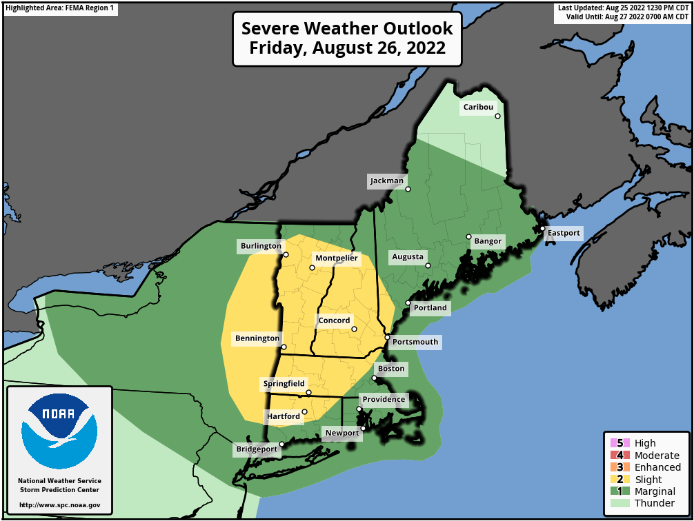
High pressure slides offshore tonight, and a cold front moves toward the region on Friday. Some showers and thunderstorms are expected ahead of the front, and a few of them could be quite strong, but it does not look like a widespread severe outbreak. Some of the storms may produce gusty winds and heavy downpours, but we probably won’t see the amount of rain we had in some of the storms earlier this week. The front moves offshore Friday night, then high pressure builds in for the weekend with dry and seasonably warm conditions. We may start to warm up a bit on Monday along with seeing humidity levels start to rise again as the high slides offshore.
There is a slight risk for severe weather across parts of New England on Friday. Image provided by the Storm Prediction Center.
Thursday night: Partly cloudy. Low 63-70.
Friday: Early sun, then clouds move in with showers and thunderstorms developing during the late afternoon. High 84-91. Offshore: South winds 10-15 knots, gusts to 20 knots, seas 2-3 feet, visibility under 1 mile in morning fog, 1-3 miles in late-day showers and thunderstorms,
Friday night: Showers and storms end in the evening, followed by clearing. Low 62-69.
Saturday: Partly to mostly sunny, not as humid. High 77-84, cooler along the coast. Offshore: East winds 5-10 knots, seas 2-4 feet.
Saturday night: Partly cloudy. Low 59-66.
Sunday: Partly to mostly sunny. High 76-83. Offshore: Southwest winds 5-15 knots, seas 2-3 feet.
Sunday night: Partly cloudy. Low 60-67.
Monday: A mix of sun and clouds. High 83-90. Offshore: Southwest winds 5-15 knots, seas 2-3 feet.
The week will start off on a damp note, but dry weather will return for a good chunk of the remainder of the week.
Low pressure will pass well north and west of the region over the next 36-48 hours. It will send a warm front toward the region today, triggering showers and possibly a few thunderstorms, but temperatures will actually remain on the cool side. Some of the models are showing the potential for some heavy rainfall today, but we’ve seen that before, and we’re not falling for it again. Will it rain? Probably. Heavy rain? Don’t count on it. Of course, we could use the rain, so it some heavy rain does materialize, that’d probably be a good thing, but we just don’t see it happening. Showers taper off tonight, and we could see some sunshine early on Tuesday. However, a cold front will be approaching, and it may trigger another round of showers and thunderstorms Tuesday afternoon and evening, mainly north and west of Boston.
Several models show the potential for heavy rain across the region today and Tuesday. We’re not buying it. Images provided by Pivotal Weather.
After that, high pressure builds in for most of the remainder of the week with very warm to hot conditions. A few showers and thunderstorms are possible during some of the afternoons, but they probably won’t be that widespread. The best chance appears to be on Friday when a frontal system moves through, with some cooler and drier air settling in for the weekend.
Dewpoints may drop into the 50s next weekend. Image provided by WeatherBell.
Monday: Mostly cloudy with showers developing, possibly a rumble of thunder. High 72-79.
Monday night: Mostly cloudy with a few more showers, mainly during the evening. Low 62-69.
Tuesday: Intervals of clouds and sunshine, chance for a few showers or thunderstorms, mainly north and west of Boston. High 76-83.
Tuesday night: A few lingering showers during the evening, then becoming partly cloudy. Low 62-69.
Wednesday: Partly to mostly sunny. High 81-88.
Thursday: Sunshine and some afternoon clouds. High 84-91.
Friday: Partly sunny, chance for some late-day showers or thunderstorms. High 82-89.
“When in drought, leave it out.” It’s an old phrase forecasters have used for quite a long time. What it means, is that when you’re in drought, rainfall will be tough to come by, so leave it out of the forecast. We found that out a few days ago when all of the models were forecasting a decent amount of rain for this area and we got little to none. Well, we’re not looking at much, if any, rainfall this weekend either.
Drought conditions continue to worse, and little relief is in sight. Image provided by the National Drought Mitigation Center.
Low pressure finally pulls away tonight and then skies start to clear out. High pressure builds in for Friday and into the weekend with dry and very warm conditions. As the high moves off to the east, humidity levels will creep up for Saturday and Sunday. Some clouds are expected on Saturday as a weak low pressure system passes well to the south. Clouds will stream back in on Monday as another frontal system moves in from the west. It could produce a few showers later Monday, but we wouldn’t count on it.
Little to no rainfall is expected across the region through late Monday. Image provided by Weathermodels.com
Thursday night: Becoming mostly clear. Low 59-66.
Friday: Sunshine and a few afternoon clouds. High 84-91. Offshore: Southwest winds 10-15 knots, seas 2-3 feet.
Friday night: Partly cloudy. Low 62-69.
Saturday: A mix of sun and clouds. High 85-92. Offshore: Southwest winds 5-10 knots, seas 1-3 feet.
Saturday night: Partly cloudy. Low 62-69.
Sunday: Partly sunny and humid. High 84-91. Offshore: Southeast winds 5-10 knots, seas 2-3 feet.
Sunday night: Becoming mostly cloudy. Low 61-68.
Monday: More clouds than sun, chance for a few showers and thunderstorms. High 77-84. Offshore: East to southeast winds 5-10 knots, seas 2-4 feet.
There’s a chance for some beneficial rainfall this week to help put a dent in the drought. Unfortunately, that chance is a lot smaller than it looked a few days ago.
High pressure will slide offshore today, allowing for another in a string of rather nice days across the region with mild temperatures and low humidity. A low pressure system will be starting to take shape off the Mid-Atlantic coast while and upper-level low also sets up residence across the Northeast. The low off the Mid-Atlantic coast will slowly rotate around the upper-level low over the next few days, passing south and east of New England. How close it gets will determine how much, if any, rainfall we get. Over the past few days, the models have been all over the place, with solutions ranging from extreme amounts of rain that would likely lead to flooding, to virtually no rain at all across the region, to everything in between. There’s still plenty of uncertainty, but we’re leaning toward the drier side of things for now, especially given the ongoing drought. We do think there will be some showers at times between late Tuesday and early Thursday morning, favoring eastern portions of the region, but we don’t think they’ll be that heavy. At this point though, every little bit helps.
Most (but not all) of the models are forecasting the bulk of the rain to stay offshore with the mid-week system. Images provided by Pivotal Weather.
By the end of the week, the low pressure both at the surface and aloft move out, replaced with high pressure, so a return to very warm and humid conditions is expected, but just a few pop-up showers and thunderstorms each afternoon. The next system will begin to approach from the west on Sunday, though the timing of this system is uncertain as well. Some models bring it in with showers and thunderstorms Sunday afternoon and evening, others hold it off until Monday. We should have a little better idea of the timing by the time we get to our Weekend Outlook Thursday afternoon.
Temperatures could get near or above 90 again on Saturday. Image provided by WeatherBell.
Monday: A mix of sun and clouds. High 77-84.
Monday night: Partly cloudy, chance for a few showers across Cape Cod and the Islands. Low 56-63.
Tuesday: Partly sunny, breezy. High 75-82.
Tuesday night: Mostly cloudy, chance for a few showers across eastern Massachusetts and the New Hampshire Seacoast. Low 58-65.
Wednesday: Plenty of clouds with a few showers possible, especially across eastern Massachusetts and southern New Hampshire, breezy. High 71-78.
Thursday: Becoming partly to mostly sunny. High 77-84.
Friday: Sunshine and some afternoon clouds. High 82-89.
Saturday: A mix of sun and clouds. High 84-91.
Sunday: Partly sunny with a chance for showers. High 79-86.