Some much-needed rain is on the way, but unfortunately much of it will fall on a holiday.
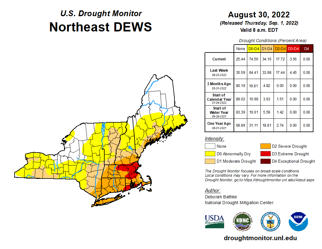
We start the week off with a cold front stalling out across the region. North of the front we’ll have some showers today with temperatures likely staying in the 60s. Closer to the South Coast, temperatures may be in the 70s with less rain at first, but still plenty of clouds. A wave of low pressure will ride along the front, bringing some additional showers or a period of steady rain in late today and tonight. By Tuesday, the front starts to push off to the south, and the shower activity winds down during the afternoon. How much rain we’ll see is still a bit of question, even as it has already started across parts of the area. Some models are still showing the potential for 3-6 inches of rain (or more) across the region, while others show less. Either way, we need all the rain we can get to help put a dent into the ongoing drought and to help refill the rivers, lakes, ponds, and reservoirs across the region. With most places likely to see at least a period of heavy rain, Flood Watches have been issued for much of the region through later Tuesday.

Skies start to clear out Tuesday night, then high pressure builds in for Wednesday right into the weekend, with a return to dry weather. After a couple of chilly day Monday and Tuesday, temperatures will return to near to above normal levels for the rest of the week and the weekend, with many days featuring highs getting back into the 80s across parts of the area once again.
Monday: Occasional showers. High 64-71 north of the Mass Pike, 71-78 south of the Pike.
Monday night: Periods of rain and showers, some of the rain could be heavy. Low 57-64.
Tuesday: Cloudy and cool with showers gradually ending during the afternoon. High 62-69.
Tuesday night: Overcast with a few lingering showers during the evening, then some late night clearing may develop. Low 53-60.
Wednesday: A mix of sun and clouds. High 68-75.
Thursday: Sunshine and a few clouds. High 72-79.
Friday: Plenty of sunshine. High 76-83.
Saturday: Mostly sunny. High 77-84.
Sunday: Partly sunny. High 77-84.
