As we head into the last week of June, we’ll enjoy some warm weather with humidity levels rising and dropping at various points.
Dewpoints could drop into the lower 50s by Friday. Image provided by WeatherBell.
A cold front will move across the region during the day today, but moisture will be limited, so only a few stray showers will likely accompany the front. Drier air settles in behind it for tonight and Tuesday. High pressure builds in behind the front on Tuesday with plenty of sunshine and warm temperatures. Another cold front will begin to approach on Wednesday, with hot and humid weather returning. As the front moves in late in the day, another round of showers and thunderstorms is expected. The timing of the front will determine whether we’re looking at more severe weather or not, but the potential exists, as long as the front moves in during the afternoon. Showers and storms come to an end late Wednesday night or early Thursday, then high pressure builds back in with cooler and drier conditions for Thursday and Friday. As that high moves offshore, warmer and more humid weather returns on Saturday. Another frontal system may move in on Sunday, with another round of showers and thunderstorms possible.
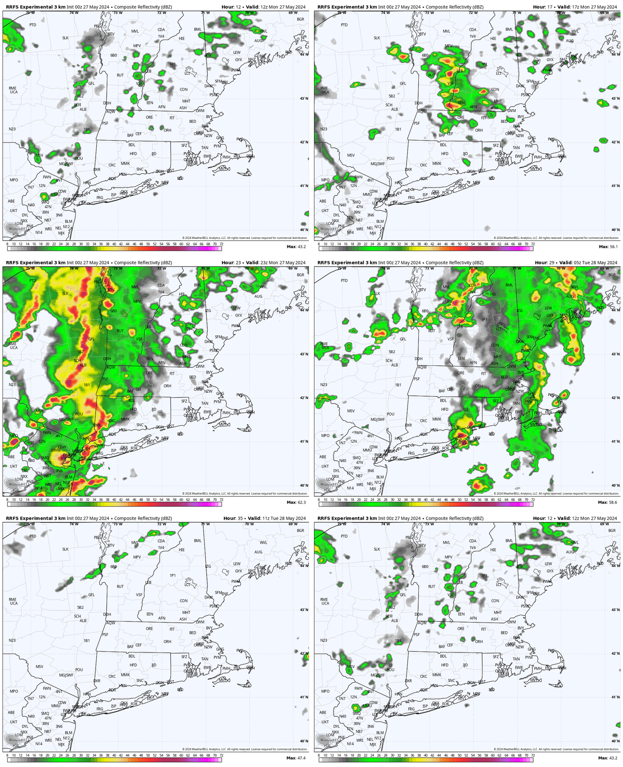
Some models have showers and thunderstorms move in late Wednesday afternoon, others wait until evening. Images provided by Pivotal Weather.
Monday: A mix of sun and clouds, slight chance for an afternoon shower. High 79-86.
Monday night: Partly cloudy during the evening, clearing overnight. Low 58-65.
Tuesday: Sunny, not as humid. High 82-89.
Tuesday night: Partly cloudy. Low 64-71.
Wednesday: Early sun, then increasing clouds, showers and thunderstorms likely late in the day and at night, breezy, more humid. High 86-93, a little cooler near the South Coast.
Thursday: Becoming partly to mostly sunny, drier. High 77-84.
Friday: Plenty of sunshine. High 73-80.
Saturday: Partly sunny. High 77-84.
Sunday: Intervals of clouds and sun, chance for some showers and thunderstorms. High 81-88.
The heat will relent for the weekend, but the humidity will take a bit longer.
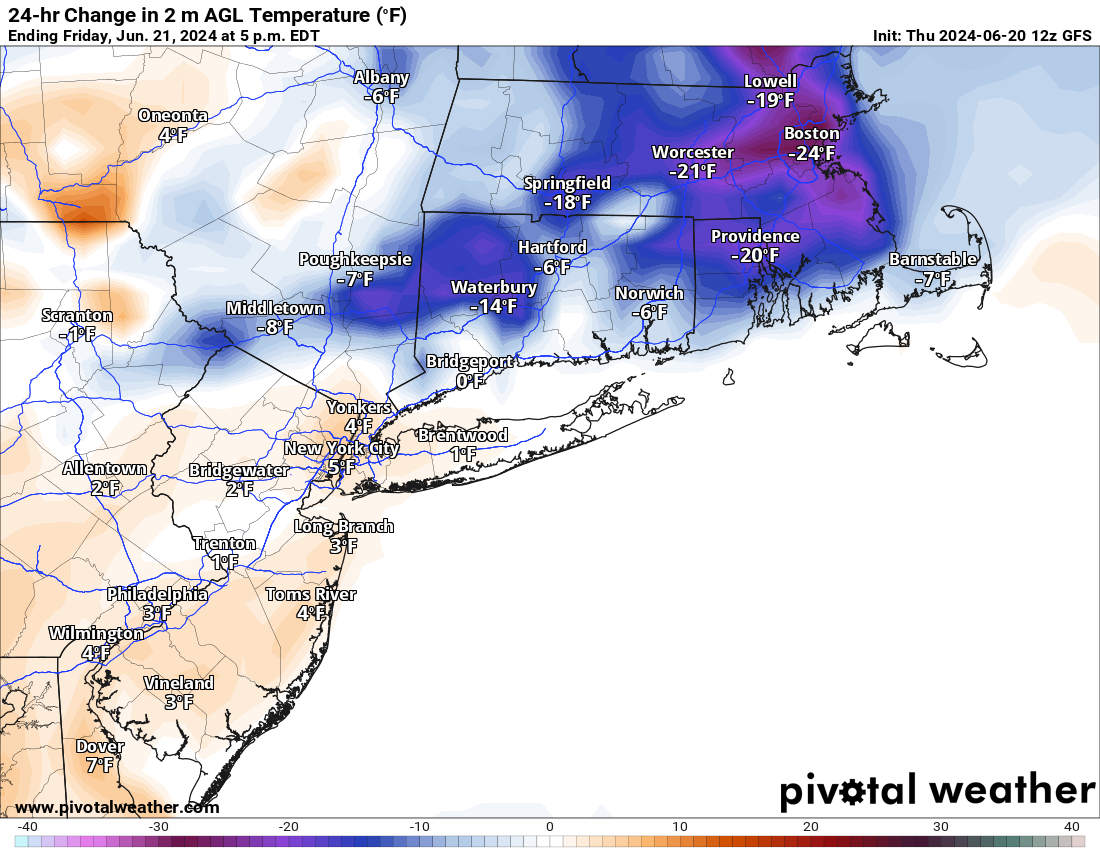
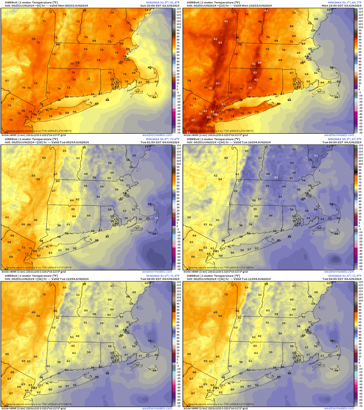
Friday afternoon temperatures will be 15-25 cooler than this afternoon across the region. Image provided by Pivotal Weather.
Today will be the last hot and humid day for a bit across the region, with some strong to severe thunderstorms bringing an end to the heat this afternoon and evening. The main threats with these storms are heavy downpours and gusty winds. Tonight will remain warm, but a backdoor cold front moves through on Friday, ushing much cooler air in, as winds shift into the northeast, and blow in over the still relatively cool Atlantic. Highs on Friday will only be in the 70s and 80s, warmest near the South Coast, where we’ll still get warm in the morning before the front moves through. Dewpoints will drop a bit, but will likely remain in the 60s, so it’ll be on the humid side still. Some showers are likely ahead of the front as well. The front stalls out near or just south of the region on Saturday, resulting in a rather comfortable day, but with a decent amount of clouds. On Sunday, that front will try to lift northward as a warm front once again, bringing the very warm and humid air back in. However, a disturbance moving in from the west will likely help to produce some showers and thunderstorms during the afternoon and evening. A cold front moves through on Monday, with warm, humid conditions ahead of it in the morning, along with more showers and thunderstorms, then cooler and drier air starts to move in by late in the day behind the front.
Dewpoints remain fairly high through the weekend, then finally start to drop late Monday. Loop provided by WeatherBell.
Thursday night: Showers and thunderstorms ending shortly after sunset, remaining partly to mostly cloudy overnight. Low 65-72.
Friday: Partly sunny with some showers likely. High 82-89 in the morning, turning cooler in the afternoon.
Friday night: Mostly cloudy, a few additional showers, mainly during the evening. Low 61-68.
Saturday: More clouds than sun, a few showers possible. High 77-84, a little cooler along the coast, especially the North Shore and NH Seacoast.
Saturday night: Mostly cloudy, chance for a shower. Low 60-67.
Sunday: Intervals of clouds and sun, breezy, showers and thunderstorms possible late in the day. High 83-90, cooler across the South Coast and Cape Cod.
Sunday night: Partly to mostly cloudy, showers taper off during the evening. Low 65-72.
Monday: A mix of sun and clouds, some showers around during the morning. High 79-86, a little cooler across Cape Cod.
Ready or not, the first heat wave of the summer is on the way later this week.
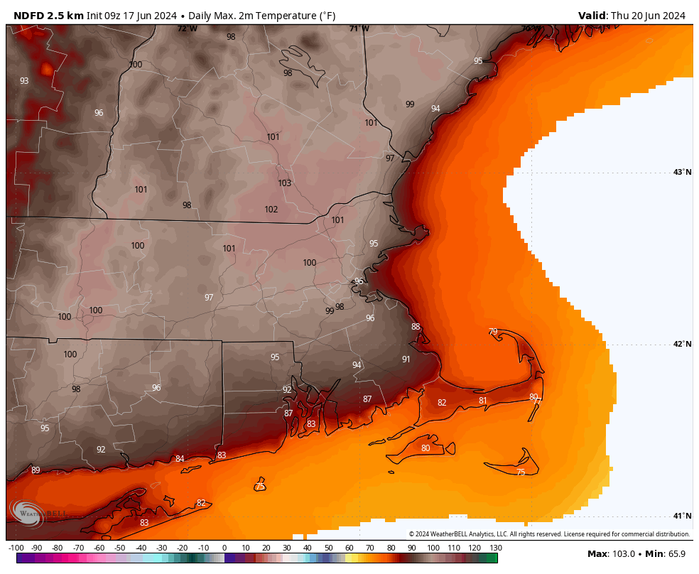
A warm front will cross the region today with just some clouds accompanying it, but little to no precipitation. Behind it, south to southwest winds will usher warmer and more humid air in, and it will remain in place for a good chunk of the week. High pressure building in both at the surface and aloft will result in partly to mostly sunny skies with hot and humid conditions from Tuesday into at least Thursday. The south winds will keep the South Coast and Cape Cod cooler, only in the 80s or even upper 70s, but inland temperatures will get well into the 90s, but when you factor in the humidity, it will feel like 95-105 degrees during the hottest part of the day each afternoon. Air temperatures could approach 100 both Wednesday and Thursday afternoon, especially from MetroWest into the Merrimack Valley, with some records possible. Excessive Heat Watches and Heat Advisories are already in effect for parts of the region from Tuesday afternoon into Friday evening. A few showers and thunderstorms may pop up each afternoon, especially Thursday, but they will be widely scattered, and only provide some relief in a few spots.
Thursday is looking like the hottest day in quite some time across the region. Image provided by WeatherBell.
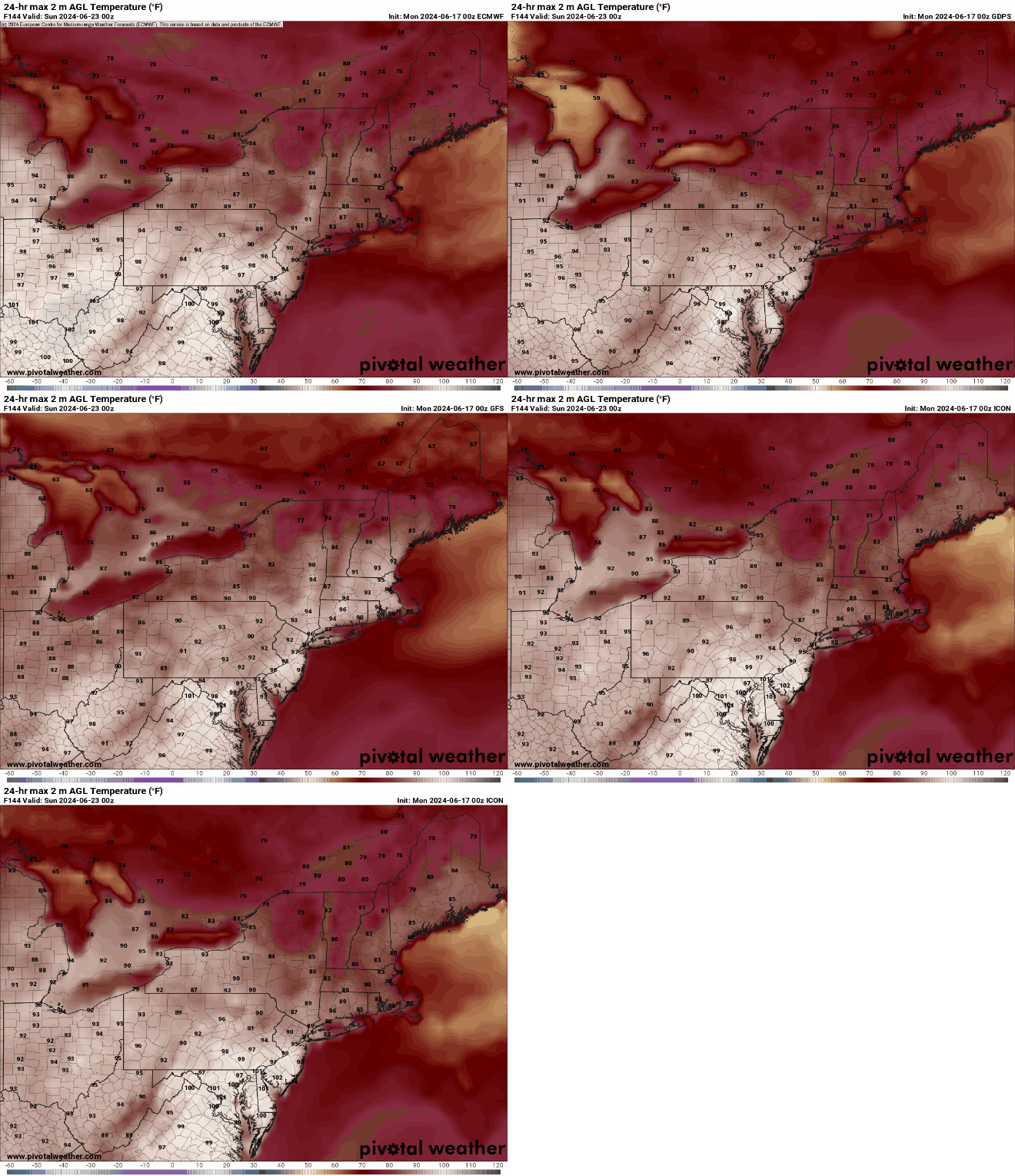
By the end of the week, a cold will start to drop down from the north, bringing more widespread showers and thunderstorms along with cooler weather, but when it moves through is still a question mark. Some models bring it down on Friday, have it lift back northward later Saturday, others have it move through on Friday, then not come back until early in the following week. This will obviously have a big impact on the temperature forecast, especially for the weekend. Some showers will likely accompany this front as waves of low pressure ride along it, but timing them is a fool’s errand at this point, because we’re not even sure yet when the front will move through.
Not all of the models have cooler air move in for Saturday. Images provided by Pivotal Weather.
Monday: A mix of sun and clouds, breezy during the afternoon. High 78-85, a little cooler near the South Coast.
Monday night: Clear to partly cloudy. Low 61-68.
Tuesday: Partly to mostly sunny. High 90-97, except 82-89 near the South Coast and 74-81 across the Cape and Islands.
Tuesday night: Clear to partly cloudy. Low 64-71.
Wednesday: Sunshine and a few clouds. High 93-100, except 85-92 near the South Coast and 77-84 across the Cape and Islands.
Thursday: Partly sunny. High 95-102, except 87-94 near the South Coast and 79-86 across the Cape and Islands.
Friday: Intervals of clouds and sun with some showers and thunderstorms possible. High 90-97, except 82-89 near the coast.
Saturday: Partly sunny, chance for an afternoon shower or thunderstorm. High 84-91, cooler near the coast.
Sunday: Intervals of clouds and sun, showers and thunderstorms possible. High 80-87, cooler near the coast.
The weekend is going to start off unsettled, but the rest of it looks terrific.
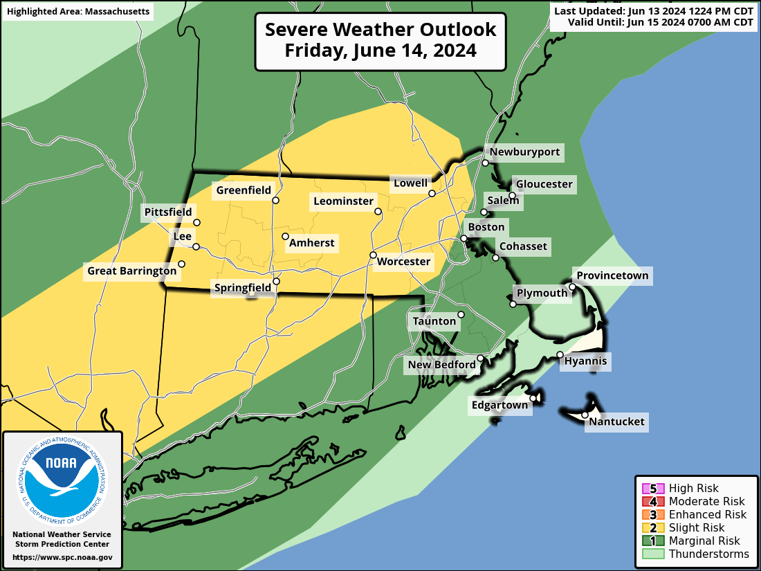
Strong to severe thunderstorms are expected on Friday, especially north and west of Boston. Image provided by the Storm Prediction Center.
High pressure will slide offshore tonight and Friday, with southwest winds bringing warm and increasingly humid air into the region. A cold front will approach from the west during the day on Friday. A line of showers and thunderstorms will develop ahead the front. Conditions should be ripe for some of these storms to become strong to severe during the afternoon and evening, especially north and west of Boston. Some of the storms produce hail and strong winds, with heavy downpours also likely. As the storms move into the Boston area and southeastern Massachusetts they should start to weaken, but some gusty winds and heavy downpours are still possible. The front moves offshore at night, bringing an end to the showers and storms, though they may not end completely until close to daybreak across parts of the Cape and possibly southeastern Massachusetts. High pressure then builds back in for Saturday and Sunday with cooler and drier air. By Monday, the high will move off to the east and warmer and more humid air will start to move back in. This will be the beginning of what looks like a hot week , but we’ll get into more details on that in our Weekly Outlook Sunday night.
The latter half of next week is looking hot around here. Image provided by Weathermodels.com
Thursday night: Clear skies, some clouds may start to drift in late at night. Low 60-67.
Friday: Morning sun, then clouds move in with shower and thunderstorms developing in the afternoon, some could be strong to severe, becoming breezy in the afternoon. High 80-87, little cooler across Cape Cod.
Friday night: Mostly cloudy with showers and thunderstorms ending from northwest to southeast. Low 57-64.
Saturday: Becoming mostly sunny and less humid. High 71-78, coolest near the coast.
Saturday night: Clear skies. Low 48-55.
Sunday: Sunshine and some afternoon clouds. High 72-79, a little cooler at the coast with afternoon seabreezes.
Sunday night: Partly cloudy. Low 53-60.
Monday: A mix of sun and clouds. High 77-84, a little cooler across the South Coast and Cape Cod.
Much of the upcoming week will feature some rather nice weather for mid-June.
Average high temperatures for mid-June are in the middle 70s across the region. Image provided by Weathermodels.com
We start the week with an upper-level low pressure area still influencing our weather for Monday and Tuesday. We’ll start both days with sunshine, but clouds will develop with a few widely scattered showers popping up each afternoon, then dissipating after sunset. Temperatures will remain a little below normal for mid-June. High pressure builds in Wednesday with drier and seasonably warm conditions. As the high slides offshore on Thursday we’ll start to turn warmer. A cold front will approach the region on Friday. Ahead of it we’ll turn even warmer with a few places possibly approaching 90 degrees. Humidity levels will also be on the increase, though we’re not expecting mid-summer humidity – dewpoints will get into the lower to perhaps middle 60s. As that front moves in, we’ll have some showers and thunderstorms move in late Friday and Friday night. The timing of the front will determine whether or not we’re looking at some severe weather. We’ll have a better idea if that is the case when we get to our Weekend Outlook on Thursday. The front moves offshore by Saturday morning, then high pressure builds back in with cooler and drier weather for the weekend.
Friday is looking like the warmest day of the week. Image provided by WeatherBell.
Monday: Sunshine and some afternoon clouds, slight chance for a shower. High 70-77.
Monday night: Clear to partly cloudy. Low 51-58.
Tuesday: A mix of sun and clouds, a stray shower is possible. High 70-77.
Tuesday night: Clear to partly cloudy. Low 54-61.
Wednesday: Partly to mostly sunny. High 73-80, coolest at the coast.
Thursday: Sunshine and a few clouds. High 80-87, cooler across the South Coast.
Friday: Partly sunny, showers and thunderstorms likely late in the day and at night. High 84-91, cooler across the South Coast.
If you’re looking for perfect summer weather this weekend, you’ll be disappointed, but it won’t be as bad as your weather app is showing.
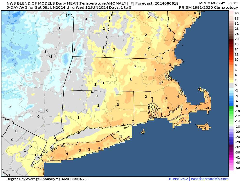
Overall, temperatures will be a little above normal over the next few days. Image provided by Weathermodels.com
A cold front will move in from the west this evening, bringing with it another round of showers and perhaps some thunderstorms as well. Beyond that, an upper-level low will drift in from the Great Lakes and sit across the Northeast through the weekend. That will keep us cooler than recent days and unsettled as well. We’re not expecting any of the days to be a washout this weekend, but what you can expect is plenty of clouds (with some sunny breaks), and daily episodes of showers, perhaps a few thunderstorms, as impulses of energy rotate around that upper low.
Some models show the potential for a few downpours over the next few days, but for the most part, precipitation totals should be on the lighter side. Images provided by Pivotal Weather.
Thursday night: A few showers possible this evening, followed by some late night clearing. Low 57-64.
Friday: A sunny start to the day, then clouds move back in during the afternoon, just a slight chance for a shower. High 77-84.
Friday night: Clear to partly cloudy. Low 53-60.
Saturday: Partly sunny, breezy, slight chance for a shower. High 71-78.
Saturday night: Partly cloudy, chance for some showers. Low 53-60.
Sunday: Intervals of clouds and sunshine, chance for a few showers, mainly in the morning. High 70-77.
Sunday night: Partly cloudy, chance for a shower or two. Low 52-59.
Monday: A mix of sun and clouds, slight chance for a shower. High 69-76.
Our stretch of nice weather will continue for a few more days, but changes are coming.
A backdoor cold front brings much cooler air in this afternoon and evening. Loop provided by Weathermodels.com
A weak disturbance passes by early in the day with some clouds and possibly a stray shower or two, otherwise, high pressure remains in control today with mainly dry conditions, but a backdoor cold front will bring some cooler weather into eastern parts of the region during the afternoon. High pressure remains in control for Tuesday with more sunshine and seasonably warm temperatures, though a seabreeze will keep coastal areas cooler. Wednesday is when the transition starts. An upper-level low starts to move out of the Midwest, sending clouds in, but we’ll remain warm, though a seabreeze is likely at the coast once again. A warm front approaches Wednesday night with showers developing, possibly a period of steady rain early Thursday. A second disturbance follows for Thursday night into Friday with another round of showers possible. With the cloud cover and rainfall, temperatures will be cooler, but probably still close to normal for early June. As the upper-level low moves through on Saturday, some additional showers are likely, possibly lingering into Sunday as well, depending on how quickly the upper-level low pressure area moves away from the region.
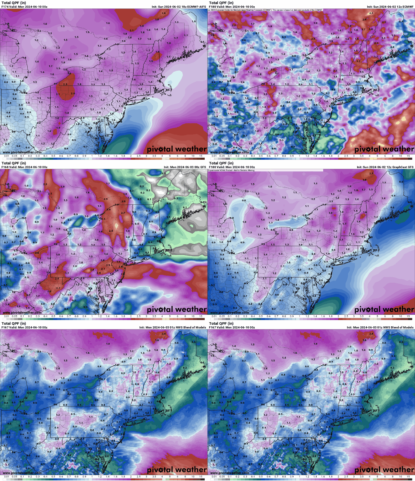
All of the models have a decent amount of rain in here for the end of the week, but some have quite a bit more than others. Images provided by Pivotal Weather.
Monday: Slight chance for a morning shower, then becoming mostly sunny. High 79-86 inland, 71-78 along the coast but dropping in the afternoon.
Monday night: Partly cloudy. Low 50-57.
Tuesday: Sunshine and some afternoon clouds. High 65-72 along the coast, 73-80 inland.
Tuesday night: Partly cloudy. Low 52-59.
Wednesday: Partly sunny, rain may develop late in the day, more likely at night. High 77-84, cooler along the coast.
Thursday: Mostly cloudy with some showers possible, especially in the morning. High 69-76, coolest near the coast.
Friday: Intervals of clouds and sun, chance for a few showers. High 70-77.
Saturday: Partly sunny, chance for a few more showers. High 69-76.
Sunday: A mix of sun and clouds, slight chance for another shower. High 70-77.
Atlantic hurricane season officially starts on Saturday June 1 and runs through November 30, and all indications are that it is going to be a very active one.
List of names for storms that form during the 2023 Hurricane Season. Image provided by NOAA.
The 2023 season was an above normal season by the numbers, with 20 named storms, 7 hurricanes, and 3 major hurricanes, but the bulk of the activity occurred during a 7-week span between August 20 and October 6. The 20 named storms was tied with 1933 for the fourth most in a single season. Hurricane Idalia made the most headlines, hitting the Big Bend region of Florida area as a strong Category 3 hurricane on August 30 after peaking as a Category 4 storm earlier that day. Hurricane Lee was the strongest storm of the season, reaching Category 5 intensity. It passed west of Bermuda and for a time looked like a potential threat to New England, eventually making landfall as a strong extratropical storm in southwestern Nova Scotia on September 16. The only other storms to make landfall in the US were Tropical Storm Harold in southern Texas on August 22 and Tropical Storm Ophelia in North Carolina on September 23. With only 3 US landfalls, and just 1 at hurricane strength this was a welcome change from 2021 when a total of 21 storms formed, 3rd most ever in a single season, and a total of eight of them made landfall in the United States. That includes 2 tropical storms that made landfall in New England that summer – Elsa and Henri. Both Elsa and Henri each made landfall near Westerly, Rhode Island about 6 weeks apart. This was just the 5th time since 1851 that two tropical systems made landfall in Southern New England or Long Island in the same year, and only the 2nd time (1961 being the other), that both storms were only tropical storm strength. (We’ll have more info on New England tropical systems a little later in this post).
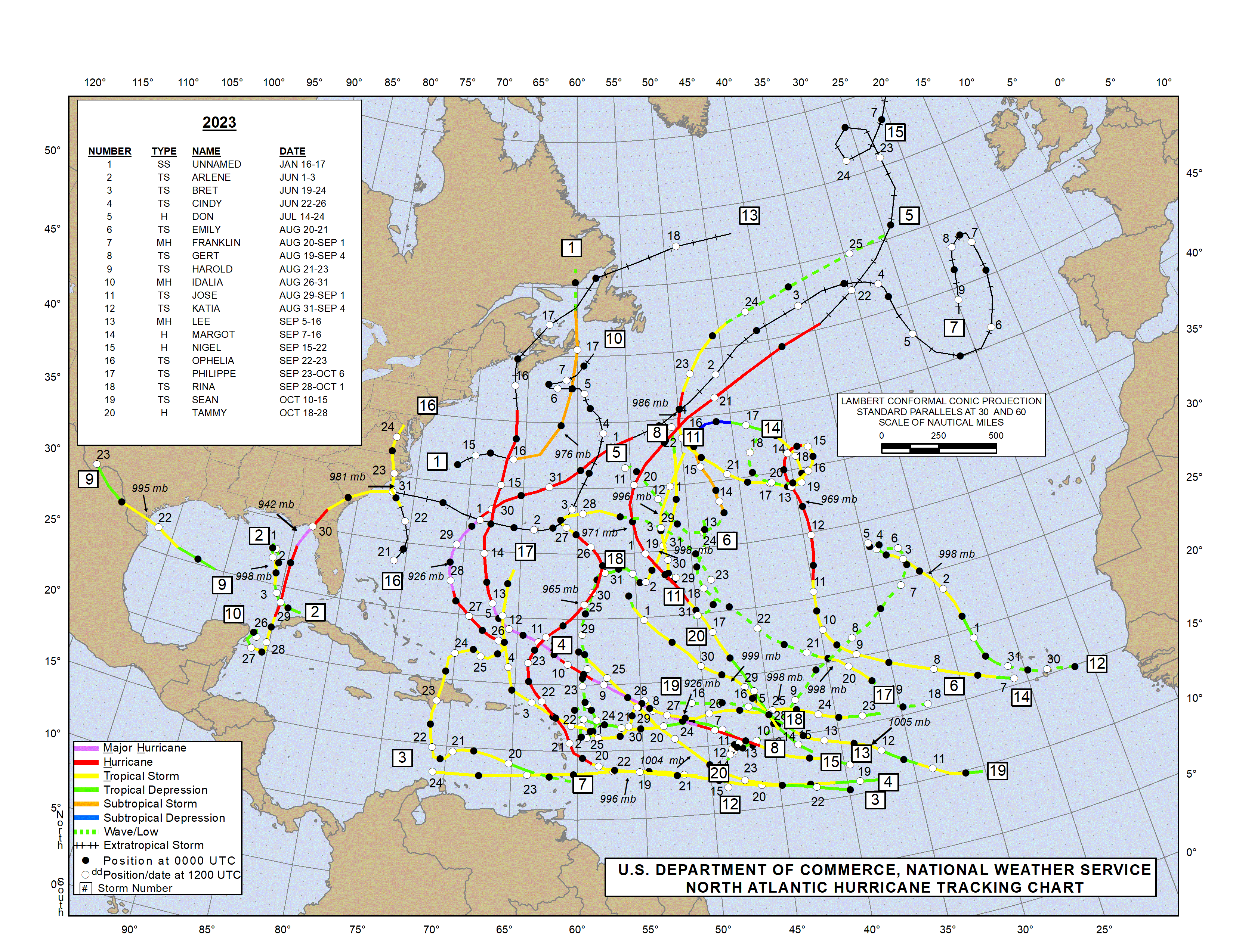
2023 was another active hurricane season. Image provided by the National Hurricane Center.
Forecasts for the upcoming season are nearly unanimous that a very active season is expected. Sea surface temperatures in the Atlantic are well above normal, near record highs in places, which would tend to lead toward a more active year. We also are transition from an El Nino to a La Nina in the Pacific, and that tends to increase Atlantic tropical activity. NOAA issued their seasonal hurricane outlook on May 23, and it calls for a 85 percent chance for an above normal season, a 10 percent chance for a near normal season, and a 5 percent chance for a below normal season. Most of the other hurricane outlooks issued by various outlets are also expecting an above to well above normal season, due to the signals mentioned above. An average season consists of 14.4 named storms, of which 7.2 become hurricanes and 3.2 become major hurricanes (Category 3 or higher on the Saffir-Simpson scale). NOAA’s forecast for this season calls for 17-25 named storms, 8-13 hurricanes, and 4-7 major hurricanes. The Tropical Meteorology Project at Colorado State, the first group to forecast how active a hurricane season would be, originally led by the late Dr. Bill Gray, will issue their updated forecast on June 11. Their initial forecast from April called for a well above average season, with 23 named storms, 11 hurricanes, and 5 major hurricanes. They also pegged the chance at a storm making landfall in the Massachusetts at 49% (33% is the average in any given year), and the odds of a hurricane making landfall in Massachusetts at 23% (14% is the average). Overall 7 of the past 8 hurricane seasons have featured above normal activity across the Atlantic.
Forecasts call for a very active Hurricane Season. Image provided by NOAA.
Despite the early start for the many of the past several years, the average date for the first named storm in the Atlantic is still June 20, and the average date for the first hurricane is August 11. Over 97% of all named storms in the Atlantic form between June 1 and November 30. Most early season storms tend to be on the weaker side. A hurricane hasn’t made landfall in the United States before July 1 since Hurricane Bonnie came ashore as a minimal hurricane near the Texas/Louisiana border on June 26, 1986.
Based on climatology, the most likely spots for an early season storm are off the Southeast coast, in the Gulf of Mexico, or the northwestern Caribbean. Image provided by the National Hurricane Center.
The number of storms that form in any given season has no correlation on how many storms (if any) will impact the United States. In 2010, 19 named storms were observed in the Atlantic, 12 of them became hurricanes, and 5 were major hurricanes. Only one storm made landfall in the United States, and that was Bonnie, which was a minimal tropical storm at landfall. In 1990, there were a total 14 named storms, 8 of them hurricanes and 1 major hurricane. Not a single one of them made landfall in the United States. On the flip side, only 7 named storms formed in 1992, and the first one didn’t develop until August 16. That storm, however, was named Andrew, and it made landfall just south of Miami as a category 5 storm. It only takes one storm to ruin your entire year.
Map showing the track of all of the hurricanes that made landfall New England or Long Island since 1851. Image provided by NOAA.
Here in New England, we should always pay attention when a storm is nearing the Bahamas, as those are the ones that have the potential to impact us, and we are extremely overdue for a hurricane to head this way. Using data back to 1851, here are some stats that show how overdue we are:
Since 1851, 39 storms of tropical storm strength of greater have made landfall in New England or Long Island, an average of one every 4.4 years. The longest we’ve ever gone without one is 11 years, between 1897 and 1908 and also between 1923 and 1934. In 2021, we had two tropical storms (Elsa and Henri) make landfall in the region.
Since 1851, 32 strong tropical storms (maximum sustained winds of 60 mph or more) have made landfall in New England or Long Island, an average of one every 5.4 years. The longest we’ve ever gone without one is 19 years, between 1897 and 1916. In 2021, we had two strong tropical storms (Elsa and Henri) make landfall in the region.
Since 1851, a hurricane has made landfall in New England or Long Island 18 times, an average of one every 9.6 years. The longest we’ve ever gone between hurricane landfalls is 38 years, between 1896 and 1934. It’s been 33 years since Bob, our 2nd longest drought on record.
Since 1851, 8 hurricanes of Category 2 intensity or stronger have made landfall in New England or Long Island, an average of one every 21.6 years. The longest we’ve gone between hits by storms of that intensity is 69 years, between 1869 and 1938. We’re at 33 years since Bob, the last one to do so.
Since 1851, New England/Long Island has had 3 Major Hurricanes (Category 3 or higher) make landfall – an unnamed storm in October of 1869 that grazed the eastern tip of Long Island before making landfall just west of Charlestown, RI; the infamous 1938 Long Island Express that made landfall near Brookhaven, NY and then again near New Haven, CT; and Hurricane Carol in 1954 which crossed East Hampton, NY and then made a 2nd landfall near Groton, CT. That’s an average of 1 every 57.7 years, and before this year, the longest time between 2 major hurricanes was 69 years (1869-1938). We’re now at 70 years since Carol, making this the longest stretch on record. There are also 3 documented storms from before 1851 – The Great Colonial Hurricane of 1635, the 1815 New England Hurricane, and the Norfolk and Long Island Hurricane of 1821. That’s it. That changes the numbers to 6 in 389 years, or one every 64.8 years, with a longest drought of 180 years.
Satellite photo of Hurricane Bob approaching New England. Bob was the last hurricane to make landfall in New England – 33 years ago. Image provided by NOAA.
We all saw what Sandy did back in 2012, and that was a minimal hurricane that eventually made landfall in southern New Jersey (technically as an extratropical storm), though there were other factors that led to the amount of damage it caused. When (not if) the next big storm comes up the coast, much of this region will not be prepared for the storm or its aftermath.
The Atlantic is quiet right now, but even if something were to form off the East Coast in the next few weeks and head this way, the waters off of New England, despite being warmer than normal, are still much too cold to sustain a tropical system, so we’d see something more like a typical nor’easter. Only two tropical storms have ever made landfall in the Northeast before the end of June. The first was an unnamed minimal tropical storm that crossed extreme eastern Long Island and went into southeastern Connecticut on May 30, 1908. The other was Tropical Storm Agnes, which made landfall near New York City on June 22, 1972, then caused devastating flooding across parts of the Mid-Atlantic states. In terms of hurricanes, the earliest one to ever make landfall up this way was Hurricane Belle, which slammed into Long Island with 90 mph winds on August 9, 1976. We did have Hurricane Arthur pass just offshore of Nantucket on July 4, 2014. While it did not make landfall, it made for a rather wet and cool holiday, especially across Cape Cod and southeastern Massachusetts. Statistically, the most likely time for a hurricane to hit New England is between the middle of August and late September. Of the 18 hurricanes that made landfall in New England or Long Island since 1851, 15 of them have done so between August 19 and September 27.
The most likely time for a tropical system to impact our area is August of September. Image provided by the National Weather Service office in Norton, MA.
As always, you should get your weather information from a trusted source (hopefully you trust us), especially when dealing with tropical systems. Much like with snowstorms in the winter, there will be plenty of hype and exaggeration on Twitter and Facebook, as well as people posting doom and gloom maps showing how a thunderstorm near the coast of Africa will develop into a Category 5 storm and head right for the East Coast in the next 2 weeks. We’re not among that group, we give you facts and our best forecasts, without any hype. If there’s reason to worry, we’ll let you know with plenty of advance warning. It’s always best to prepare ahead of the season. Chances are, you won’t have anything to worry about, but in case you do, it’s always good to be prepared.
The first weekend of June should feature some fantastic weather for our area.
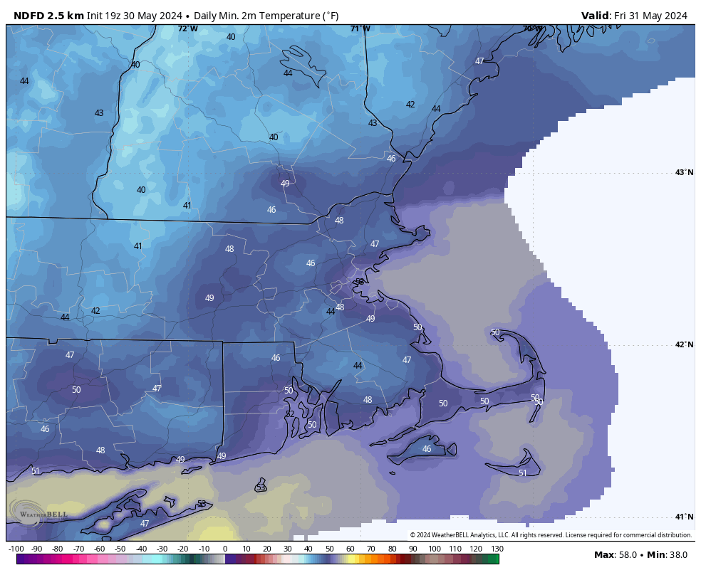
It’ll be on the chilly side if you’re heading out early Friday morning. Image provided by WeatherBell.
Low pressure pulls away from the region this evening, taking the last of the showers with it, then skies clear out, resulting in a chilly night, with temperatures dropping into the 40s in many areas. High pressure builds in for Friday with sunshine and temperatures turning milder, but still near or a little below normal for the final day of May. We’ll warm up more on Saturday as the high moves off to the East. A weak system will try to move in on Sunday, bringing us some clouds, but it looks like any rain with it should stay off to our south and west. Sunshine returns on Monday, with just a few pop-up showers or thunderstorms possible in the afternoon, mainly across the interior.
Most of the models keep any rain south and west of our area on Sunday. Images provided by Pivotal Weather.
Thursday night: Any lingering showers end this evening, then skies clear out. Low 44-51.
Friday: Sunshine and some afternoon clouds. High 68-75, coolest along the coast.
Friday night: Clear skies. Low 47-54.
Saturday: Plenty of sunshine. High 74-81, a little cooler near the coast.
Saturday night: Partly cloudy. Low 50-57.
Sunday: Partly sunny, just a slight chance for a late-day shower. High 75-82, a little cooler near the coast.
Sunday night: Partly cloudy. Low 53-60.
Monday: Partly to mostly sunny, a pop-up shower or thunderstorm is possible in the afternoon. High 76-83, a little cooler near the coast.
Unsettled weather is expected to start the week, but the end should be drier.
We could see a few showers this morning, but the heavier ones are likely this evening. Loop provided by Weatherbell.
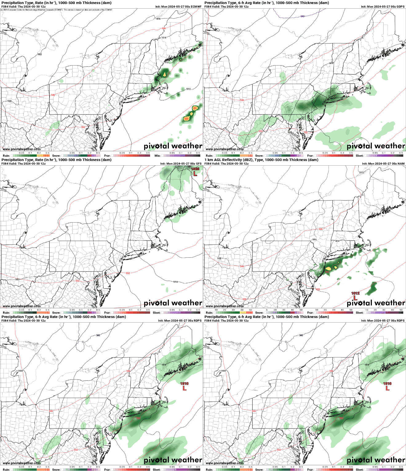
Low pressure heading into southeastern Canada will send a warm front toward the region today, but it likely stays to our south, meaning we’ll be cooler than the last several days. A few showers are possible ahead of the front during the morning and early afternoon, but the bulk of the rain should accompany the cold front later Monday and Monday night. Some of that rain could be heavy, but flooding isn’t too much of a concern, as it the rain should end fairly quickly. In fact, as the cold front moves offshore, we’ll quickly clear out on Tuesday with warmer temperatures return. After that, an upper-level low pressure area will settle into the Northeast, with cooler weather return for the middle to latter half of the week. Clouds will return on Wednesday as another system approaches the region. This system may bring in some more rain for Wednesday night into Thursday, but there is quite a bit of spread in the model solutions for this next system, so how much rain, if any, and when to expect it, is still highly uncertain. High pressure then builds in for the end of the week and the weekend, with a warming trend expected.
Will we have some rain Wednesday night and Thursday? That remains to be seen. Images provided by Pivotal Weather.
Editorial Note: Our annual start of hurricane season blog, including stats about how overdue we are heading into which is expected to be a very active season, will be published on Friday, in advance of the official start of hurricane season on Saturday.
Monday: Plenty of clouds, some areas of fog to start the day, especially south of Boston, some showers possible during the morning and early afternoon, becoming more widespread late in the day, breezy in the afternoon. High 67-74.
Monday night: Cloudy with rain and some thunderstorms likely, possibly heavy, ending shortly after midnight. Low 57-64.
Tuesday: Early clouds, then becoming partly to mostly sunny. High 76-83, cooler along the South Coast.
Tuesday night: Clear skies. Low 55-62.
Wednesday: Sunny in the morning, then increasing clouds, showers possible at night. High 71-78.
Thursday: More clouds than sun with a chance of showers. High 64-71.
Friday: Partly sunny. High 65-72.
Saturday: A mix of sun and clouds. High 67-74, a little cooler near the coast.
Sunday: Partly sunny. High 71-78, cooler along the coast.










 Storm HQ