This shouldn’t be a surprise, since it’s February, but there’s snow in the forecast.
Today’s sunshine and cool temperatures are a product of high pressure building in across the eastern Great Lakes. However, as that high slides off to the east, low pressure, currently in the western Gulf of Mexico, will slowly make its way toward the region. However, it’s not as simple as a storm system passing off to the south and bringing in some snow. This will actually be a three-part system that lasts quite a while.

The initial low pressure system will move off the Southeast coast and head northeastward, passing south of the area late Thursday and Thursday night. This will spread some light snow in Thursday afternoon and evening, mainly south of the Mass Pike. As that system pulls away, another weak system will emerge from the Carolina coast, spreading more snow in. This will overspread most of the area. Along the South Coast, we’ll see some milder air move in, especially aloft, which will likely result in some sleet or rain mixing in. That system pulls away early Friday, but yet another weak system follows in its wake, passing south of the area during the day on Friday, with even more snow expected, even down to the South Coast, as some cooler air filters in behind the previous system. That system finally pulls away Friday night, but with an upper-level low pressure system moving across the Northeast, some more snow showers are possible on Saturday.

It’s important to note that this isn’t your classic Nor’easter with a powerful system off the coast, strong winds, and bursts of heavy snow. Instead, we’re just left with a series of weak systems that will produce off-and-on light snow for a period of 24-to-36 hours across the region. Of course, even light snow will add up if it persists for that long, but this isn’t the “blockbuster” 1-to-2 feet that we sometimes receive at this time of year.
So, how much are we expecting?
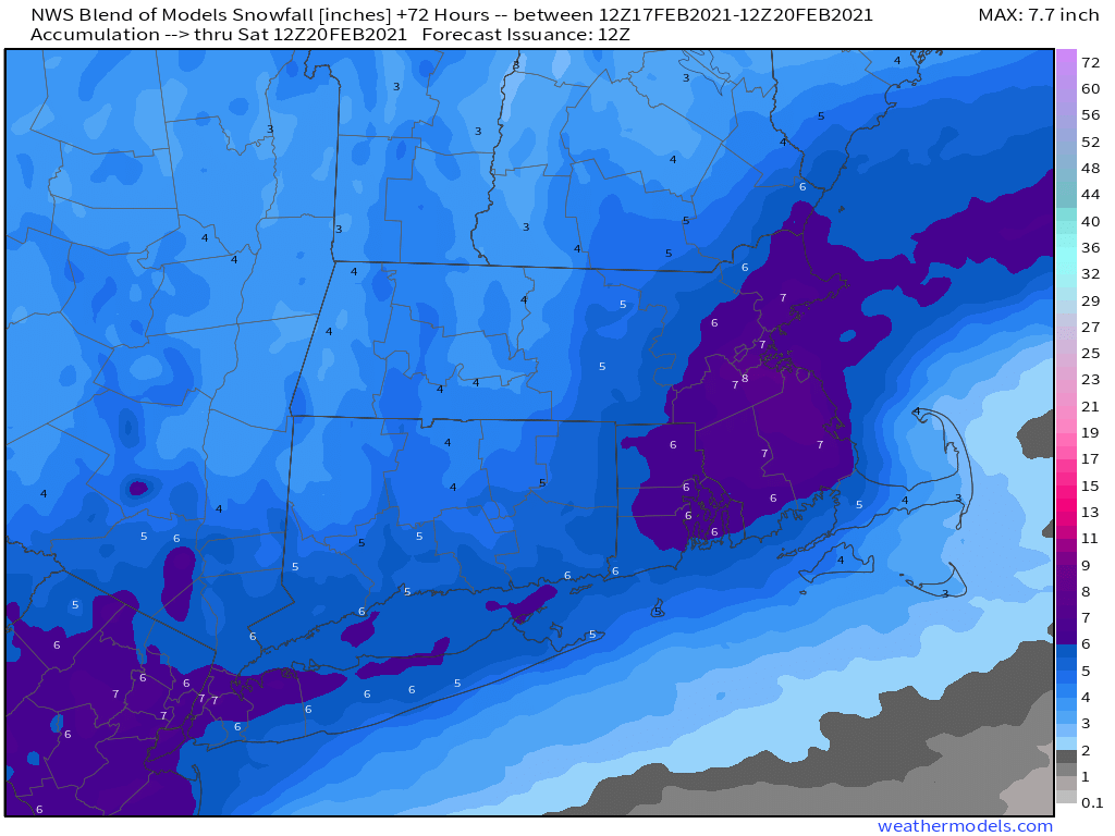
Central NH (Concord): 2-4″
Southern NH (Manchester/Nashua): 2-5″
NH Seacoast/Merrimack Valley: 3-6″
MetroWest/MetroBoston: 4-7″
Southeastern Massachusetts/RI: 5-9″
South Coast: 4-7″
Cape Cod: 3-6″ (heaviest near the Canal)
Another system may bring in some light snow or rain on Monday. We’ll have a little more detail on that in our Weekend Outlook tomorrow.
