We really haven’t had a decent-sized snowstorm around here since mid-December. That will change in a hurry on Monday. As a result, the Extreme Hype Watch we issued on Thursday has been upgraded to an Extreme Hype Warning.

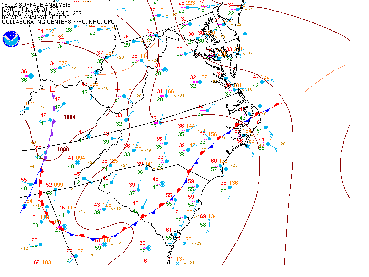
High pressure remains in place across Quebec, keeping plenty of cold air in place across the Northeast this afternoon. Meanwhile, low pressure is moving across the Ohio Valley, producing a swath of snow from the Great Lakes into the Mid-Atlantic states. As that low moves eastward, it will weaken tonight, but a new area of low pressure will develop off the Mid-Atlantic coastline. At the same time, and upper-level low pressure area will also move toward the East Coast. As the new surface low gets caught underneath the upper-air low pressure area later Monday and Monday night, it will stall out or meander around south of Long Island. Eventually, it will resume an east to northeast motion on Tuesday, passing south and east of Nantucket before moving into the Gulf of Maine.

As we mentioned, an Extreme Hype Warning has been issued, which means you’ll see blanket coverage from the network stations around here, hourly updates even when they go to regular programming, and of course, obligatory live shots from (take your pick):
- The side of an Interstate
- Logan Airport
- A local DPW salt pile
- A beach showing the rough surf and coastal flooding
- A Dunkin Donuts where they are talking to a plow operator
- All of the above
You’ll also get network reports about how the snow is creating chaos in New York City, how it put Washington at a standstill, and possibly how it dumped heavy snow on the Midwest. The latter is debatable, because anything west of the Appalachians is considered “flyover country” to the media around here.
OK, we’ve explained what’s going on in the big picture, now let’s focus on some of the details for our area (Southern New Hampshire, Eastern Massachusetts, Rhode Island):

As you can see on the radar above, snow is already moving into the Tri-State area, and will continue to make slow progress northward tonight. By morning, east to northeast winds will start to increase around here, and we’ll see some ocean-effect snow showers develop in parts of southern New Hampshire and eastern Massachusetts. These aren’t directly related to the storm, but may drop 1/4-1/2″ of snow. This is also a common occurrence before some storms around here. The snowfall from the storm will move in during the late-morning and early afternoon hours and should become moderate to heavy by late afternoon or early evening. Snow may fall at the rate of an inch or two per hour at times. This will continue overnight with precipitation starting to taper off before daybreak. For much of the region, that precipitation will fall as all snow, but a change to rain is likely along the coast and across parts of southeastern Massachusetts and southern Rhode Island. How far inland that rain-snow line penetrates will obviously have a large impact on accumulations. Right now, we don’t expect it to get past Interstate-95, and it might not even get that far.
By Tuesday morning, the steady precipitation will taper off, but the storm will still be south of Long Island. So, what we’re looking at is occasional snow showers and periods of light snow throughout the day, with rain or mixed precipitation in southeastern Massachusetts and southern Rhode Island, This likely won’t add too much accumulation, but in some places, we could see another inch or two. As the low finally gets moving, colder air will work its way back in, changing everywhere back to all snow before it ends late Tuesday night or Wednesday morning.
There are several factors that could cause problems around here. First and foremost is the wind. Northeast winds will increase to 15-25 mph inland, and 20-30 mph along the coast, with gusts of 30-50 mph. This will create near-blizzard conditions at times Monday night, with reduced visibility and blowing and drifting snow. If you don’t have to go out Monday night, stay home. Driving will be extremely hazardous. Across Cape Cod and the Islands, a High Wind Warning is in effect. Sustained winds of 25-35 mph with gusts to 60 mph are possible here. Winds will only slowly diminish across the region on Tuesday.

Along with the wind, we have coastal flooding to worry about. A Coastal Flood Watch is in effect for eastern Massachusetts, mainly for the high tide cycles Monday night and Tuesday morning. Those strong northeast winds, combined with tides that are still astronomically high, will likely produce some coastal flooding, especially in some of the normally prone areas (like Morrissey Boulevard in Boston). By Tuesday afternoon, winds will become more northerly, reducing the coastal flood threat.
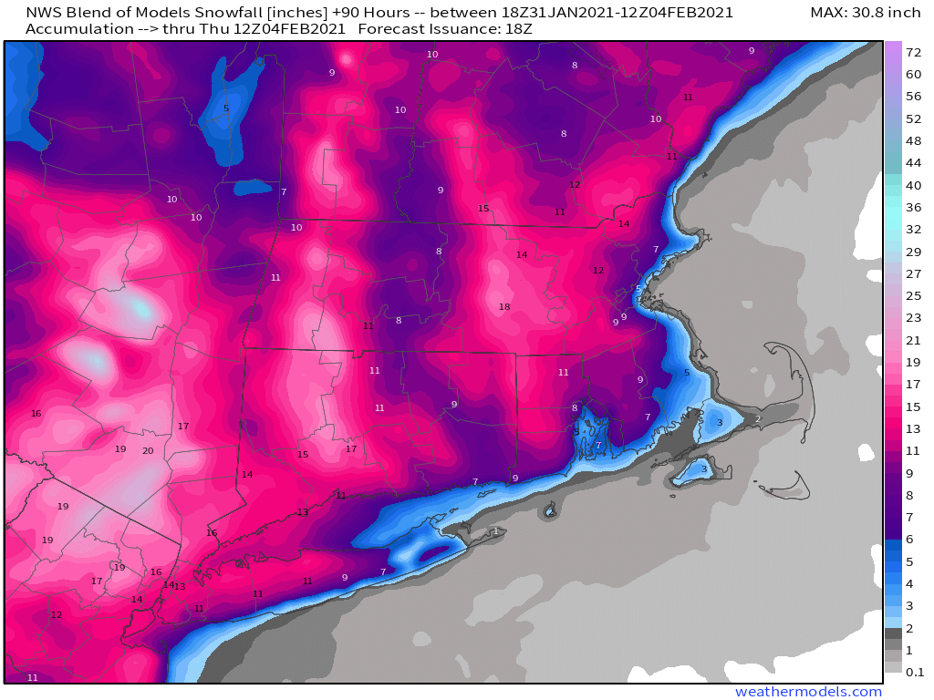
Finally, we get to the part you’re all interested in – how much snow? The good news is that they heaviest snow from this storm will likely be south and west of us, from southeastern New York and northern New Jersey into parts of Pennsylvania. Many locations in this area could see 20 or more inches of snow before everything winds down. Even New York City could see a foot to perhaps a foot and a half of snow. Around here, there will likely be many reports in excess of a foot, especially north and west of Boston. As for specifics, here’s what we’re thinking:
Cape Cod: 1-3″, heaviest near the Canal
South Coast/Immediate East Coast: 3-6″
Interior Southeastern Massachusetts/I95 Corridor from RI into Eastern MA: 6-10″
Areas North and West of Interstate-95 (including southern/Central NH): 10-15″ with some heavier amounts possible.

Obviously, some of these amounts are dependent on when/if rain starts to mix on or a complete change to rain occurs. Most of the accumulating snow will occur between late Monday afternoon and daybreak Tuesday, but there will still be some snow falling during the day on Tuesday.
Another storm will move in late this week, but this one looks to be milder, with rain for a bigger chunk of the region, though snow is a possibility across the interior. We’ll have more on that in our Weekly Outlook tomorrow morning.
Thanks for this post. I’m firmly in the Extreme Worry section on the coast in regards to snow weight. I hate shoveling the heavy stuff!
LikeLike