Since our last blog post about the tropics yesterday, we’ve had some subtle, but important changes with most of the systems we’re watching.
As of early Wednesday afternoon, Hurricane Florence was centered about 485 miles southeast of Wilmington, North Carolina, moving toward the northwest at 15 mph. Maximum sustained winds are near 130 mph, making Florence a Category 3 Hurricane. Florence may strengthen a bit today as it moves over the warmer waters of the Gulf Stream while continuing on a northwestward track. Once it gets close to the coastline is where things start to get complicated.

The upper-level steering currents will collapse as the storm nears the coastline, which will cause the storm to slow down, and perhaps even stall out. Many of the models show this stall, followed by a slow drift toward the southwest. Exactly where it stalls is somewhat important. If the storm makes landfall, and then stalls out over southern North Carolina, it will quickly weaken, lessening the wind impact, but prolonging the heavy rainfall. If the storm stalls while the center is still offshore, it will weaken more slowly as it slowly churns up the warm water it is sitting over, but this will prolong the wind and storm surge impacts along the coast.
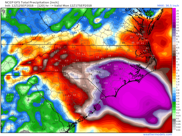
These changes are actually a bit of good news for some areas, and bad news for others. This shift in track will significantly lessen the impact and amount of rainfall expected across the Mid-Atlantic states and even northern parts of North Carolina. While heavy rain is still expected, rainfall totals of 2-4 inches and locally heavier will not cause as much flooding as 6-12 inches of rain would. To the south, this is bad news – really bad news. The impact of rain, wind, and storm surge will be prolonged across southern North Carolina, and now will extend into a large portion of South Carolina. If the southwest trend in the track were to continue even longer, as a few models of shown, these impacts could even spread into parts of Georgia.
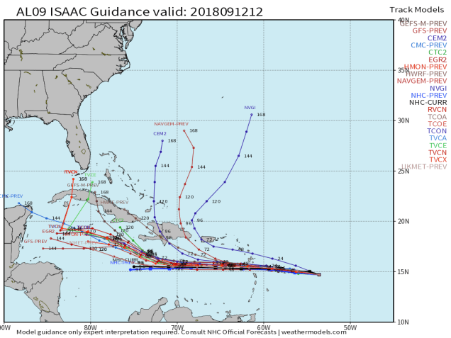
To the south, Tropical Storm Isaac is looking even weaker today, and the threat to parts of the Caribbean is diminishing. As of early Wednesday afternoon, Isaac was centered about 420 miles east of Martinique, moving toward the west at 17 mph. Maximum sustained winds have decreased to near 60 mph. Westerly shear has been impacting Isaac since Tuesday afternoon and is starting to rip the system apart. Since this shear is not expected to relax for another day or two. Tropical Storm Watches and Warnings are in effect for much of the Lesser Antilles. Isaac should cross the islands early on Thursday, bringing heavy rain and gusty winds to the region. However, the system should continue to weaken, and could degenerate into an open wave as it moves into the eastern Caribbean. It will still bring some heavy rain into Puerto Rico and the Virgin Islands, but won’t have anywhere near the impact of last year;s powerful storms. Some of the forecast models show the potential for the system to regenerate and strength as it moves into the western Caribbean this weekend, so even if the system does become an open wave in the next day or two, we’ll still keep an eye on its progress as it heads westward.

As for Hurricane Helene, not much has changed. As of midday Wednesday, Helene was centered about 1350 miles south-southwest of the Azores, moving toward the north-northwest at 14 mph. Maximum sustained winds remain near 90 mph. Helene is expected to continue northward, steadily weakening while move over cooler waters. The current forecast calls for Helene to pass very close to or over the Azores this weekend as a tropical storm. Heavy rain and gusty winds would be the main threats to the Azores. The system should lose tropical characteristics over the weekend, but may impact parts of the British Isles as a strong extratropical system early next week.

Meanwhile, an area of disturbed weather is slowly getting organized in the Gulf of Mexico. If this trend continues, the system could become a tropical depression tonight or Thursday. It should continue on a west to west-northwest track, heading towards Texas. The main threat with this system will be heavy rains across portions of southeastern Texas, likely leading to flooding in some areas.
Another disturbance is developing several hundred miles west of the Azores. Conditions are favorable for more development and this system could also become a tropical storm in the next day or so. This system will likely remain over open waters for the next several days, and is not a threat to any land areas right now.
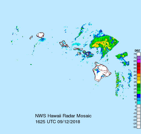
In the Pacific, Tropical Storm Olivia is gradually weakening while approaching the Hawaiian Islands. As of Wednesday morning, Olivia was centered about 140 miles east of Honolulu, moving toward the west at 12 mph. Maximum sustained winds have decreased to near 45 mph, and some additional weakening is expected. Tropical Storm Warnings remain in effect for Oahu and Maui County. Olivia will continue to bring heavy rain and gusty winds to the islands today. Rainfall totals of 5-10 inches and locally heavier will produce flooding in some areas. Once past the islands, Olivia should continue westward, likely dissipating over the open waters of the Central Pacific later this week.

In the western Pacific, Tropical Storm Barijat remains fairly weak. As of midday Wednesday, Barijat was centered a little more than 100 miles south-southwest of Hong Kong, moving toward the west at 10 mph. Maximum sustained winds were near 45 mph, and Barijat is expected to slowly weaken while continuing westward, likely making landfall in southern China over the next 12-18 hours. Heavy rain may lead to flooding across portions of southern China and northern Vietnam before the system dissipates.
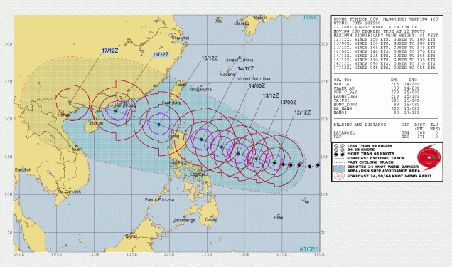
Meanwhile Super Typhoon Mangkhut remains a beast of a storm this afternoon. As of midday Wednesday, Mangkhut was centered about 870 miles east of Manila, moving toward the west at 14 mph. Maximum sustained winds are near 170 mph, making Mangkhut the strongest storm on the planet so far this year. Mangkhut has likely peaked in intensity, and a slow weakening trend is expected over the next few days. As for Mangkhut’s future, the forecast track has shifted a bit to the south since yesterday. This will now bring the center of the storm close to or over northern portions of Luzon, the largest of the islands in the Philippines. The northern tip of the island is somewhat rural, with hilly terrain, which means the storm wouldn’t affect as many people, but it will still be at or close to Super Typhoon intensity at the time, so a major impact is still expected. After that, a track into the South China Sea is still expected, with some additional weakening likely before a final landfall late this weekend early next week in the same vicinity of where Barijat is expected to make landfall today or tomorrow.
