We’ve entered the final week of September, and once again, we’ve got a little bit of everything in the forecast this week (except for snow).
The week starts off on a chilly note as high pressure moves across Maine and into Atlantic Canada. There will likely be frost and freezing temperatures across Northern New England to start the day. With high clouds filtering the sunshine and a chilly airmass in place, temperatures may struggle to reach 60 across our area. We commented to our fellow blogger and friend at Woods Hill Weather a few days ago that Monday looked like the first “Stop at Dunks for a Hot Chocolate” afternoon of the year.

The cool air won’t hang around too long, as a warm front will move through late Tuesday. It will be preceded by some heavy rainfall. While this round of rain won’t compare to last week, when many places picked up 2-4 inches or more, we are still looking at 1-2 inches of rain for much of the region, which will lead to some nuisance flooding and ponding on roadways. The heaviest of the rain looks to fall from right around the morning commute until right around the evening commute. So, much of the day will be a washout.
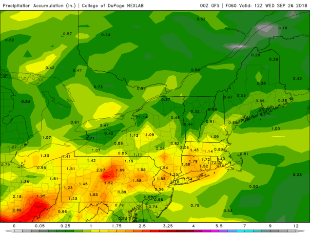
Wednesday will actually be another warm and humid day. with the warm front north of the region Temperatures should get well up into the 70s, with some lower 80s possible if we can get enough sunshine. However, you’ll need to keep the umbrellas handy once again. We may have some lingering showers in the morning, especially south of Boston, but it’s the afternoon that we need to keep an eye on. With a cold front approaching from the west, some thunderstorms will likely develop, and some of them could be strong to severe. The main threats with these storms will be heavy downpours and strong winds. While severe weather is uncommon in New England this late in the year, it is not unheard of. In fact, one of the strongest tornadoes ever recorded in New England, an F4, struck Windsor Locks, Connecticut on October 3, 1979.
Once the cold front moves through, high pressure builds in for the end of the week and into the weekend with dry and seasonably mild conditions. There are a few chances for a little rain, depending on which forecast model you happen to look at. So, this period might not be completely dry, but we’re certainly not looking at a washout either, at least not at this point.
Monday: Sunshine filtered through high clouds, but those clouds will start to thicken up late in the day. High 56-63.
Monday night: Cloudy. Low 47-54.
Tuesday: Breezy with periods of rain developing. possibly heavy at times. High 62-69.
Tuesday night: Rain tapers off to occasional showers, gradually ending overnight. Low 58-65 in the evening, then temperatures slowly rise overnight.
Wednesday: A few lingering showers south of Boston early, otherwise plenty of clouds with some sunny breaks. Breezy. Showers and thunderstorms develop in the afternoon, some of which may contain gusty winds and heavy downpours. High 73-80.
Thursday: Partly to mostly sunny. High 63-70.
Friday: Sunshine and a few clouds. High 64-71.
Saturday: Mostly sunny. High 65-72.
Sunday: Intervals of clouds and sunshine, slight chance for a shower. High 62-69.
