Memorial Day has arrived – the traditional start of summer. While much of the upcoming week will feel like summer, today will feel like Spring, which of course, it still is.
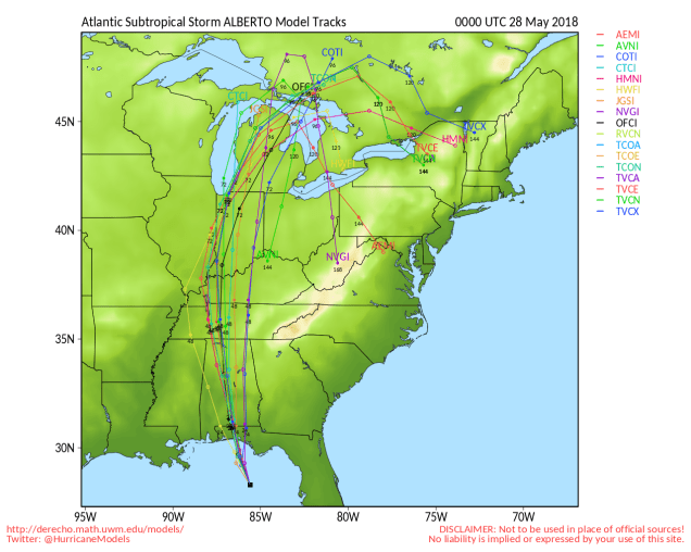
We’ll start off this forecast with a quick update on Alberto. As of 11pm Sunday, subtropical storm Alberto was centered about 95 miles south-southwest of Apalachicola, Florida, moving toward the northwest at 9 mph. Maximum sustained winds were near 65 mph. Landfall is expected near or just east of Fort Walton Beach, Florida Monday morning. While gusty winds and storm surge will be threats along the coastline, the much bigger threat will be heavy rain and flooding across much of the Southeast over the next few days, spreading into the Tennessee and Ohio Valley towards midweek. Alberto, or what’s left of it, could impact our weather late in the week (More on that in a bit).
Up here, the forecast is fairly easy for much of the week. High pressure starts to build into the region today. We’ll start the day off with some clouds and cool temperatures, but sunshine will develop, and temperatures will actually warm up close to where they should be in late May. After that, with high pressure in control, sunny and warm conditions are expected for Tuesday through Thursday.
At the end of the week is where things get interesting. What’s left of Alberto heads towards the St. Lawrence Valley on Friday, sending clouds and showers into the region, but it should remain warm. The bigger questions come during the weekend. A secondary area of low pressure will form, possibly bringing some steadier and heavier rain to the region. The question that the models haven’t resolved yet is “where does it form?” One model suggests it forms right over the Northeast, then moves offshore before stalling out, which would mean a rainy Saturday, but improving conditions on Sunday. Another model suggests that it forms to the south, which means a rainy and warm Saturday and a rainy and much cooler Sunday. Yet another model also says that it forms to the south, but so far south that high pressure builds in on Sunday, so after a rainy Saturday, we’d have clearing but also chilly temperatures on Sunday. At this point, we’re not sure which way to go, so we’ll play the middle ground (yeah, it’s a cop-out, but it’s also a week away, so give us a break).

Memorial Day: A cloudy start, maybe a little drizzle as well, then skies become partly to mostly sunny in the afternoon. High 60-67 along the coast, 68-75 inland.
Monday night: Clear to partly cloudy. Low 53-60.
Tuesday: Partly to mostly sunny. High 80-87.
Tuesday night: Clear skies. Low 50-57.
Wednesday: Plenty of sunshine. High 72-79, coolest along the coast.
Thursday: A mix of sunshine and clouds. A few showers are possible at night. High 78-85, cooler along the south coast.
Friday: Mostly cloudy with a chance of showers. High 76-83.
Saturday: Cloudy and breezy with showers likely, possibly a period of steady rain. High 70-77.
Sunday: Partly to mostly cloudy and breezy with a chance of showers. High 63-70.
