70 degrees. In July, that’s a chilly high temperature. In February, it’s a record breaker. We’re going to be challenging and possibly breaking some records this week. Don’t get too used to it though, as our early taste of Spring will be short-lived.

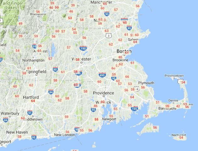
The week starts out with a warm front moving towards the region, spreading in some clouds, and eventually showers on Monday. The front moves through Monday night, then a Bermuda High sets up shop for a couple of days, with unseasonably mild conditions expected for Tuesday and especially Wednesday. How mild? Most locations should reach the upper 50s to middle 60s on Tuesday. On Wednesday, most places should get into the 60s, with some lower 70s possible, especially north and west of Boston. Of course, there is an exception. Along the South Coast, the southwest winds that will bring warmer air in for the rest of us will be blowing in off of water that is still in the 30s. So, these locations will likely stay in the upper 40s and 50s both days. Still nice, but it’s not 60s and 70s.
A cold front moves through Wednesday night, bringing a few showers with it, but also bringing an end to the mild weather. Showers may linger along the south coast into early Thursday before the front pushes offshore, then high pressure builds in from the north with much cooler conditions for Thursday and Friday. Of course, “much cooler” is relative, as these temperatures will still be near to a little above normal for late February. Another storm system then moves in from the west, with some precipitation likely late Friday into Saturday. It should fall mostly as rain, but a period of snow or freezing rain is possible, especially across the Merrimack Valley and southern New Hampshire Friday night into Saturday. We’ll keep an eye on this situation as the week goes on. Another system quickly follows with more rain or snow on Sunday.

Monday: Becoming mostly cloudy and breezy with showers possible late in the day. High 42-49.
Monday night: Showers likely in the evening, otherwise mostly cloudy and breezy. Low 39-46 in the evening, then temperatures rise overnight.
Tuesday: Becoming partly sunny, breezy, and milder. High 57-64, except 49-56 along the South Coast and across Cape Cod.
Tuesday night: Partly to mostly cloudy. Low 46-53.
Wednesday: Partly sunny, breezy, and warm. Showers possible at night. High 65-72, except 49-64 along the South Coast and across Cape Cod.
Thursday: Clouds gradually giving way to some sunshine late in the day, turning much cooler. High 41-48.
Friday: A sunny start, then clouds return. Showers likely at night, possibly starting as some snow or freezing rain in the Merrimack Valley and Southern New Hampshire. High 37-44.
Saturday: Mostly cloudy and turning milder with a chance of showers, possibly some wintry mix early in the day across southern New Hampshire. High 47-54.
Sunday: Cloudy and breezy with a chance of rain or snow. High 36-43.
