In our Weekly Outlook this past Monday, we talked about a storm heading into the Great Lakes this weekend, with a warm front bringing rain and mild conditions on Saturday, but Friday would be cool as the warm front struggled to cross our area. Well, things have changed considerably, and not for the better.
Low pressure will still move into the Great Lakes Friday/Saturday, and a warm front will get hung up to our south. The problem is, that warm front may not make it any farther north than the South Coast. Even worse, we’re looking at precipitation streaming in on Friday, continuing more or less into Saturday afternoon. Cold air in place, precipitation moving in, warmer air eventually moving in aloft. If you’ve lived around here long enough, you that means we’re looking at a snow to freezing rain situation.
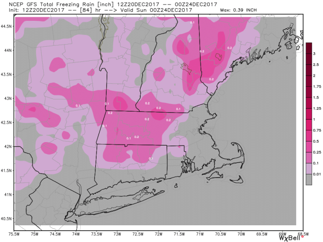
Snow should develop across southern New Hampshire and northern Massachusetts around midday Friday, with a mix of snow, sleet and freezing rain moving into the Boston area during the afternoon, and rain, possibly mixed with a little snow south of Boston by late in the day. Eventually, a change to freezing rain will take place north and west of Boston Friday night as warmer air moves in aloft. The problem is, that cold air at the surface will be pretty tough to dislodge. Temperatures will slowly drift up, likely getting above freezing by Saturday morning inside Route 495. However, from the Merrimack Valley into southern New Hampshire, there is the chance that temperatures never reach 32, or if they do, it won’t be until late in the day, after most of the precipitation has fallen.

Before the change to freezing rain, we are looking at some snow accumulation, mainly north and west of Boston. As much as 1-3″ could fall in the Merrimack Valley, with 3-5″ from the Seacoast over into southern New Hampshire. If the changeover takes even longer than we currently expect, then these totals could end up higher.

As for the potential for a White Christmas – we told you on Monday that the odds were low, but not zero, despite what some of the folks on TV were saying. Well, those odds have raised significantly. After a cold front moves through here late Saturday, it will stall offshore. Another wave of low pressure will ride along it on Christmas Day. Exactly where that front stalls is obviously key to the forecast. There’s still a large range in what the models are showing – anything from just a few flurries to heavy snow inland with rain along the coast, but it certainly seems like we’re in for *something* on Christmas Day. We’ll take a look at that in more detail once we get past the Friday/Saturday storm. Oh, and if you hear any hype for another storm next week – yes, the models are showing something, but it’s still over a week away. We don’t have to tell you that the forecasts can and will change several times before then, because you already knew that. Remember, it was just 2 days ago that we were talking about highs in the 50s on Saturday, not an ice storm.
