We’ve all heard the opening line of the song more times than we can remember:
“I’m dreaming of a white Christmas, just like the ones I used to know”
Well, this year, it won’t be a dream for a large portion of the region, it’ll be reality. Across southeastern parts of New England, mainly south and east of I-95, – sorry, it’ll be a green Christmas for you, with mostly rain from the system.
Christmas Eve will actually be a fairly nice December day by New England standards. We’ll start the day with some sunshine, but clouds will move in during the afternoon as low pressure moves into the eastern Great Lakes. High temperatures will reach the upper 30s to lower 40s, which is right around normal for late December.

As we head into Sunday night, right around the time Santa is making his rounds, snow will break out across the region, with rain across southeastern Massachusetts and parts of Rhode Island. At the same time, a secondary area of low pressure will start to take shape off the Mid-Atlantic coastline. This low will start to head northeastward, likely passing very close to, or perhaps right over, the Outer Cape, on Christmas morning. As a result of this track, the rain/snow line will likely penetrate as far inland as a Boston-Providence line. Obviously, any variation in track will impact how far inland that warmer air penetrates, which will impact the snowfall forecast. The snow will come down at a steady pace for much of Christmas morning, tapering off and ending by midday as the storm moves into the Gulf of Maine, where it will really get cranked up (more on that in a moment).
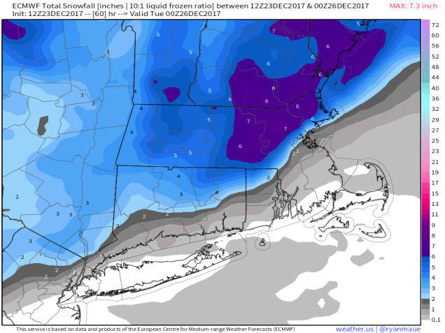
So, how much are we looking at?
If you live south and east of a line that runs from Boston to Providence (roughly Interstate 95), probably just a brief dusting at the tail end of the storm as colder air comes back in as the precipitation is ending.
If you live just west of I-95, from Northern Rhode Island into the Boston area and Metro West, 1-3 inches.
Anywhere outside of there, especially the I-495 belt from Central Massachusetts into the Merrimack Valley, North Shore, Southern New Hampshire, and the New Hampshire Seacoast, 3-6 inches, with some isolated spots picking up as much as 8 inches.
As the system moves into the Gulf of Maine Monday night into Tuesday, gusty winds are likely behind it, ushering much colder air into the region. Low temperatures Tuesday morning will drop into the middle teens to lower 20s, but wind chills will be in the single numbers and even below zero in spots Tuesday morning. This is also bad news for places that had mainly rain during the day, as it will ice everything up in the evening, creating some slippery travel. This bitterly cold air looks to remain in place for much of the week as a large area of high pressure builds in. We’ll get into more detail in our Weekly Outlook Monday morning, but this high pressure area is good news, as it may help to deflect a potential storm later in the week off to our south (much to the chagrin of the Facebook Forecasters who were already trumpeting about a potential snowstorm a week in advance because some of the models showed it).

One thought on “Bing’s Dream Will Be Reality for Most of Us.”