Weekly Outlook: February 27 – March 5, 2023

We’ve got a rather turbulent week coming up across the region.

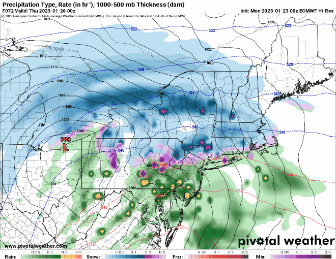
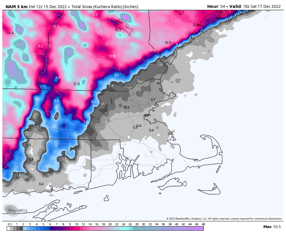
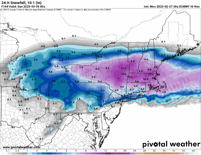
High pressure will be in control to start the week, with a mostly dry Monday, but a storm system is on the way. Low pressure will cross the Great Lakes and head up the St. Lawrence Valley while weakening. Meanwhile, a secondary area of low pressure will develop off the Mid-Atlantic coast and head eastward. We’ll be in between the two, which means some light to perhaps moderate snow developing Monday night continuing into Tuesday. The Tuesday morning commute is going to be rough, so plan accordingly. As temperatures rise to near or above freezing, we may see a change to rain, especially across southeastern Massachusetts, possibly into the Boston area. So, the afternoon commute may not be as bad, especially south of Boston. The snow winds down during the evening. Despite earlier model predictions and internet hype, this will NOT be a big storm. In general, most of us will see 2-5″ of accumulation, perhaps a little less along the coast, perhaps a little more near the hills from northwestern Rhode Island into central Massachusetts and southwestern New Hampshire.

This will be a light to moderate snowstorm for the region. Image provided by WeatherBell.

Wednesday starts off dry, but another weak disturbance moves through late in the day with a few rain or snow showers possible. Another system quickly follows for Thursday, but this one looks warmer, as it will pass north of the region, so some rain showers are expected, maybe some freezing rain as you head up into central New Hampshire. That system moves offshore Thursday evening, then high pressure builds in, but it doesn’t hang around for too long. Yet another system quickly follows for late Friday into Saturday. There’s still plenty of uncertainty with this one, but it looks to pass near or just south of the region, so more snow is possible, or perhaps a mix of snow, sleet, and rain. Obviously, we’ll have a better idea of what this storm will bring (we hope), but the time we get around to our Weekend Outlook on Thursday. Yet another weak disturbance may bring in some snow showers Saturday night and early Sunday before high pressure builds back in.

The models have differing ideas on the potential for a storm late Friday and Saturday. Images provided by Pivotal Weather.

Monday: Morning sun, clouds return in the afternoon. High 30-37.

Monday night: Cloudy with snow developing. Low 21-28, temperatures may rise a little after midnight.

Tuesday: Breezy with snow likely, possibly mixing with rain south of Boston. High 33-40.

Tuesday night: Snow (or rain), ending in the evening, some clearing after midnight. Low 22-29.

Wednesday: Some morning sun, clouds move back in during the afternoon, snow or rain showers possible in the evening. High 40-47.

Thursday: Mostly cloudy, breezy, and mild with rain showers likely. High 46-53.

Friday: Mostly cloudy and breezy, snow, sleet, rain developing late in the day, becoming windy at night. High 35-42.

Saturday: Wintry mix ending in the morning, some sunny breaks in the afternoon, then some more snow showers possible at night, windy. High 32-39.

Sunday: Some morning snow showers, becoming partly sunny, breezy. High 34-41.

Weekend Outlook: February 24-27, 2023

Winter has finally arrived, and it looks like it may hang around for a while.

Most of the snow overnight fell north of the Mass Pike. Image provided by the National Weather Service office in Norton, MA.

The second half of our double-barreled low pressure system will move across the region this evening and tonight, with another round of sleet, freezing rain, possibly some light snow, and plain rain near the South Coast. This round of precipitation should be light, and done shortly after midnight. A strong cold front moves through Friday morning, possibly accompanied by a few snow showers. We’ll gradually clear out behind it in the afternoon, but strong northwest winds will usher much cooler air in, with temperatures dropping during the day. High pressure settles in Friday night, resulting in a rather chilly night, with lows dropping into the single numbers, possibly below zero in some of the colder spots, especially into southern New Hampshire. There will still be some wind around, so wind chills will drop below zero. Saturday will be a chilly day, but clouds will quickly return and thicken up as a weak disturbance moves through, possibly producing a few snow showers. Another weak system moves through on Sunday, with a few more snow or rain showers possible, then drier weather returns for Sunday night and early Monday. Clouds move back in during the day on Monday ahead of yet another storm system.

Wind chills likely will be below zero for much of the region when you wake up Saturday morning. Image provided by WeatherBell.

We don’t normally go beyond Monday on the Weekend Outlook, but wanted to address the next storm system currently expected to move in for Monday night and Tuesday. Some of the forecast models have shown the potential for a sizeable snowstorm around here on Tuesday. As you’d expect, the model snow maps have spread like wildfire across the internet. The thing is, right now, it’s just that – potential. The potential storm is still 5 days away, and the forecast models have been horrendous beyond about 2 or 3 days, so why should we trust the models with a 5-day forecast? The Ensembles also show the potential for a snowstorm, but a light to perhaps moderate one, not the blockbuster storm some of the operational models are showing. Yes, this winter has been fairly non-existent until the last few days, but a well-advertised pattern change has taken place. That doesn’t mean that suddenly every storm is going to be all snow (the current one isn’t). We’ll obviously have a lot more detail in our Weekly Outlook early Monday morning, but for now, don’t get too concerned about the chance for a blizzard on Tuesday. Certainly you should be prepared for a storm (it is winter in New England after all), but if there’s cause for concern, we’ll let you know.

Many of the 31 members of the GFS Ensemble show only a light to moderate snowstorm Tuesday, highlighting the uncertainty with that system. Image provided by Weathermodels.com

Thursday night: Cloudy with a wintry mix of light snow, sleet, freezing rain, and plain rain near the South Coast, ending after midnight. Low 19-26 north of the Mass Pike, 27-34 south of the Pike during the evening, temperatures may rise a bit overnight.

Friday: Clouds with some afternoon sunny breaks, windy, a few stray snow showers are possible in the morning. High 31-38 in the morning, temperatures drop through the afternoon.

Friday night: Clearing, except across the Outer Cape, breezy, and cold. Low 3-10.

Saturday: Becoming cloudy with a few flurries possible. High 19-26.

Saturday night: Partly to mostly cloudy. Low 8-15.

Sunday: Mostly cloudy with a chance of snow or rain showers. High 34-41.

Sunday night: Becoming partly cloudy. Low 15-22.

Monday: Early sun, then increasing clouds. High 32-39.

Weekly Outlook: January 23-29, 2023

A fairly active weather pattern is on deck for this week, with several bouts of unsettled weather expected.

We’re starting the week off on a stormy note with low pressure passing south of the region. Colder air will work its way in behind the storm today, allowing the rain/snow line to move southward as the day progresses. So, even places that are still raining this morning will likely see some snow before the day is out and the storm pulls away. Areas south of the Mass Pike will likely see an inch or less of accumulation, with another 1-3 inches north of the Pike, and possibly a little more than that across southern New Hampshire. Everything ends this evening, then high pressure briefly builds in tomorrow with drier conditions.

Much of the region will only pickup another inch or two of snow today. Image provided by WeatherBell.

However, another storm will quickly follow for Wednesday. With some cold air in place, this one will likely start as snow across the region Wednesday afternoon, making for a rather messy afternoon commute. However, with the low passing west of us, and a secondary low pressure system developing right overhead, warmer air will move in, resulting in a change to rain Wednesday evening and night, ending Thursday morning. As that system pulls away, breezy and cooler conditions settle in late Thursday into Friday, but a cold front will approach the region on Saturday. That front may produce some snow showers Saturday afternoon and evening before it pushes offshore. Wel clear out behind it and turn colder, but yet another system quickly follows late Sunday, with some rain or snow showers possible late in the day ahead of a warm front.

Most of the models show snow falling for the Wednesday afternoon commute. Images provided by Pivotal Weather.

Monday: Breezy with snow likely north of the Mass Pike, rain changing to snow south of the Pike. High 34-41 early, temperatures drop during the afternoon.

Monday night: Snow ending in the evening, followed by clearing, windy. Low 22-29.

Tuesday: Morning clouds, some afternoon sun, breezy. High 35-42.

Tuesday night: Clear through the evening, clouds return after midnight. Low 17-24.

Wednesday: Cloudy with snow developing in the afternoon, changing to rain from south to north during the evening. High 32-39.

Thursday: Windy with periods of rain, ending in the afternoon. High 39-46 north and west of I-495, 47-54 south and east.

Friday: Partly to mostly sunny, breezy, and colder. High 32-39.

Saturday: Mostly cloudy and breezy with a few snow showers possible, clearing late in the day. High 37-44.

Sunday: Becoming mostly cloudy and breezy, snow or rain showers possible late in the day. High 35-42.

Weekend Outlook: January 20-23, 2023

We’re getting into a more active weather pattern around here, and also one that is a bit more wintry.

Tonight’s storm will bring a little bit of everything to the region. Loop provided by Weathermodels.com

Low pressure will head into the Midwest tonight while a secondary area of low pressure develops across the northern Mid-Atlantic states and passes just south of New England tonight. Rain will overspread much of the region over the next few hours, except for central New Hampshire, where precipitation will likely start as some snow. As that secondary area of low pressure passes by to the south tonight, winds will shift into the north, allowing cooler air to settle in, and the rain/snow line to start migrating southward. The steadiest precipitation likely ends before daybreak, but the old low pressure system will move through during the day on Friday, with occasional snow showers north and west of Boston, and occasional rain showers changing to snow showers from Boston southward. The rain/snow line likely doesn’t reach the South Coast before everything winds down late Friday afternoon or evening. How much snow can we expect?

South and east of I-95: Less than 1″
MetroWest/North Shore: 1-2″
Merrimack Valley/NH Seacoast: 2-4″
Southern/Central NH: 3-6″

This will not be a big snowmaker for much of our region. Image provided by Pivotal Weather.

We may see some clearing on Saturday as high pressure tries to move in, but clouds quickly return Saturday night as another system heads toward the region. This one looks to be mostly rain for Sunday night into Monday morning, but it may start as snow across southern New Hampshire, and the rain may change to snow before ending across the region Monday morning. We’ll clear out behind the system Monday afternoon, but it will be quite breezy.

Northwest winds may gust to 30-40 mph Monday afternoon. Image provided by WeatherBell.

Thursday night: Rain developing across the region, except snow across central New Hampshire. Rain changes to snow as we head through the night across southern New Hampshire and the Merrimack Valley. Low 29-36.

Friday: Occasional snow showers north and west of Boston, with rain showers changing to snow showers from Boston southward. High 34-41 in the morning, temperatures drop during the day.

Friday night: Mostly cloudy, any lingering rain or snow showers end in the evening. Low 20-27.

Saturday: Becoming partly sunny. High 30-37.

Saturday night: Clouds return. Low 11-18 across southern New Hampshire and the Merrimack Valley, 19-26 elsewhere.

Sunday: Mostly cloudy. High 36-43.

Sunday night: Cloudy and becoming windy with rain likely, possibly starting as snow across southern New Hampshire. Low 30-37, temperatures may rise a bit overnight.

Monday: Rain may change to snow before ending in the morning, becoming partly sunny and windy in the afternoon. High 40-47 early, temperatures drop during the day.

Weekend Outlook: January 6-9, 2023

The weather pattern will start to quiet down again this weekend, but not before some of us get some snow on Friday.

Drizzle and fog (and a little freezing drizzle) will gradually taper off tonight as a cold front continues to push offshore. An upper-level system quickly follows for Friday. With colder air in place, precipitation will be mainly in the form on snow north and west of Boston, while areas near the coast and south of Boston likely see mostly rain, with some snow mixed in, especially as everything winds down. Snow likely develops during the late morning hours and ends during the evening. It should be mostly light, but some bursts of moderate to perhaps heavy snow are possible. For accumulations, south and east of I-95 will have some slush at most. Areas north and west of I-95 are looking at a general 1-2″ with some spots possibly picking up 3-4″ if these heavier bursts do materialize. We’ll still have some clouds around on Saturday, then we should clear out for Sunday and Monday with seasonably chilly conditions expected.

Friday’s snow shouldn’t be a big deal, especially as you get closer to the coast. Image provided by WeatherBell.

Thursday night: Plenty of clouds, drizzle and fog linger, especially during the evening. Low 31-38.

Friday: Mostly cloudy, light snow developing north and west of I-95, rain south and east, possibly changing to snow late in the day. High 35-42.

Friday night: Snow and rain end in the evening, then skies become partly cloudy. Low 27-34.

Saturday: Intervals of clouds and sunshine. High 36-43.

Saturday night: Becoming mostly clear. Low 19-26.

Sunday: Sunshine and a few clouds. High 31-38.

Sunday night: Partly cloudy. Low 23-30.

Monday: Partly sunny. High 37-44.

Weekend Outlook: December 16-19, 2022

A rather complex storm system is heading this way, but the forecast itself isn’t too complex for most of us.

The storm system that’s been producing blizzard conditions in the Plains and severe weather in the South over the last few days will head towards the Great Lakes tonight as a secondary area of low pressure takes shape over the Mid-Atlantic states. That system will pass close to or over southeastern Massachusetts Friday night. Ahead of it, we’ll have rain moving into the region tonight. The rain may start as some wet snow across the hills of Worcester County and southwestern New Hampshire, possibly even in parts of south-central New Hampshire and the Merrimack Valley, but gusty easterly winds will quickly bring milder air in off the still relatively mild Atlantic, quickly changing any snow over to rain at the lower elevations. Friday will be a windy, rainy, and cool day across the region. Wind may gust as high as 40-50 mph near the shoreline, but with tides astronomically low, coastal flooding is not a concern. As the storm passes by Friday night, winds will shift from the east to the northeast and eventually north and northwest, bringing cooler air back in. The precipitation will be moving out, but the rain will likely change over to snow before it ends around midday across southern New Hampshire and possibly the Merrimack Valley. As for accumulations, we’re looking at an inch or less across the Merrimack Valley and the New Hampshire Seacoast, an inch or possibly two across southern New Hampshire (including Nashua and Manchester), and 3-5 inches up towards Concord. Across the hills of northern Worcester County and the Monadnocks of southwestern New Hampshire totals of 6-12 inches or more are likely.

The heaviest snow will be confined to the hills north and west of the region. Image provided by WeatherBell.

Once the storm moves out, temperatures will slowly drop during the day on Saturday, then skies start to clear out at night. An upper-level low pressure system moves across the region on Sunday with some additional clouds and possibly a few flurries. High pressure then builds in for Monday with sunshine and seasonably cool conditions.

Sunday’s temperatures will be a little below normal for mid-December, Image provided by Weathermodels.com

Thursday night: Rain developing, possibly starting as a brief period of wet snow across southern New Hampshire, becoming breezy. Low 33-40 in the evening, then temperatures slowly rise overnight.

Friday: Windy with periods of rain, possibly heavy at times. High 39-46.

Friday night: Rain may change back to snow across southern New Hampshire, breezy. Low 30-37.

Saturday: Cloudy and breezy with rain or snow showers ending by midday. Some sunny breaks may develop late. High 37-44 in the morning, temperatures drop during the afternoon.

Saturday night: Becoming clear to partly cloudy. Low 23-30.

Sunday: Intervals of clouds and sun, chance for a few flurries, breezy. High 33-40.

Sunday night: Clear to partly cloudy. Low 21-28.

Monday: Plenty of sunshine. High 35-42.

Weekend Outlook: December 9-12, 2022

Cooler weather is on the way, and it looks like may even a little snow too.

High pressure builds in with cool and dry conditions tonight and Friday. Some clouds may start to filter in for Friday night and Saturday as a large ocean storm starts backing in. With a persistent east to northeast flow around this storm, we could see some drizzle or a few showers on Saturday across parts of eastern Massachusetts, especially Cape Cod. The clouds hang around on Sunday as another low pressure system moves into the eastern Great Lakes before heading southeastward, passing south of New England Sunday night and early Monday. It will spread some precipitation in, and with temperatures near or below freezing at night, it may fall in the form of snow. Most of the precipitation will fall west of our area, but some snow showers or even a period of light snow seems likely. For many of us, it will probably be enough to coat the ground, with a few spots possibly seeing an inch or so, except across Cape Cod and southeastern Massachusetts, where it will be more rain than snow. This is not a big storm, and most of the snow will fall Sunday night and early Monday, so keep that in mind if you’ll be out and about. The system pulls away on Monday, and high pressure builds back in with sunshine returning.

A little light snow is expected Sunday night. Image provided by WeatherBell.

Thursday: Clear skies. Low 25-32.

Friday: Plenty of sunshine. High 38-45.

Friday night: Clear through the evening, clouds start to move in late at night. Low 22-29, a little milder across southeastern Massachusetts.

Saturday: Mostly cloudy, chance for some drizzle or a few showers, mainly across Cape Cod and southeastern Massachusetts. High 33-40.

Saturday night: Mostly cloudy, showers or drizzle taper off in the evening. Low 22-29, a little milder across southeastern Massachusetts.

Sunday: Plenty of clouds, snow showers possible late in the day, mixed with rain across Cape Cod. High 31-38.

Sunday night: Scattered snow showers, except rain or snow showers across Cape Cod. Low 23-30.

Monday: Any lingering rain or snow showers end early, becoming partly to mostly sunny in the afternoon. High 34-41.

Weekly Outlook: November 14-2,0 2022

Uh oh. It’s that time. You might want to sit down. Yup. We’ve got some bad news for you. That word is in the forecast. You know which one we’re talking about. The one that you really don’t like. At all. It’s 4 letters, begins with “s” and ends with “w” and it rhymes with “no”. Yeah, that word. You knew it was coming eventually, but you still didn’t want to hear (or read) it. Well, it’s too late. You’ve been warned.

We start the week off with high pressure in control for Monday. The result is plenty of sunshine, but rather chilly temperatures, a stark contrast to what we had over the weekend. But, it is November, and the nice weather can’t last forever, because this is New England, not Miami or San Diego or St. Croix. Tuesday looks dry and chilly too, but we’ll have clouds streaming in ahead of a low pressure system moving toward the region.

Normal high temperatures for mid-November are within a degree or two of 50. Iage provided by Weathermodels.com

Tuesday night, some moisture will start streaming in ahead of that storm, and with temperatures likely near or below freezing, we may see some (WARNING: BAD WORD INCOMING) “snow” developing across the area. For areas from Boston southward, it may be just a few flurries or sprinkles Tuesday evening. The more substantial moisture moves in overnight, with most rain in the I-95 corridor and points south and east. North and west of there, especially outside of I-495, some wet snow may develop, but even here, it should change to rain by daybreak. The pavement remains far too warm for any accumulations (except for bridges and overpasses), but grassy surfaces, and car windshields could see some slushy accumulation, perhaps up to an inch as you head into southern New Hampshire. Across the Worcester Hills and up into the Monadnocks, there could even be a little more than that. Everything changes over to rain during the morning, and rain continues into the afternoon before winding down. There could be some gusty winds along the coast as well, but all in all, this is not a big deal. Across parts of Cape Cod and potentially southeastern Massachusetts, temperatures could briefly spike into the 50s or even 60s if the low tracks across the area, but for the rest of, Wednesday will feature temperatures in the 40s or even 30s.

If you’re out and about before daybreak Wednesday, precipitation may not be all rain. Images provided by Pivotal Weather.

An upper-level trough of low pressure crosses the Northeast of Thursday with some clouds and possibly a few sprinkles or flurries. High pressure then builds in for the end of the week and the weekend with generally dry and chilly conditions.

Temperatures on Saturday could be 10-15 degrees below normal. Image provided by WeatherBell.

Monday: Plenty of sunshine, breezy at times. High 40-47.

Monday night: Mostly clear skies. Low 21-28.

Tuesday: Some morning sun, then clouds stream in. High 39-46.

Tuesday night: Cloudy with light rain developing at night, starting as light snow or a wintry mix north and west of Boston, gradually changing to all rain by daybreak. Up to an inch of slushy accumulation is possible on grassy surfaces north and west of I-495. Low 27-34, temperatures slowly rise after midnight.

Wednesday: Any lingering wintry mix changing to all rain, ending during the afternoon. High 40-47 north and west of Boston, 48-55 south, potentially warmer across Cape Cod.

Thursday: Partly sunny, breezy, chance for a rain or snow shower. High 40-47.

Friday: Partly to mostly sunny, breezy. High 39-46.

Saturday: Sunshine and a few clouds. High 37-44.

Sunday: Partly to mostly sunny. High 38-45.

Weekend Outlook: March 11-14, 2022

While the clocks “spring ahead” with Daylight Saving Time beginning this weekend, we’ll still be dealing with winter at times.

High pressure remains in control into Friday with generally dry weather. We’ll be on the chilly side tonight, but temperatures should rebound nicely on Friday, though we’ll see clouds streaming in and thickening up late in the day. This is in advance of a developing low pressure system that will impact us on Saturday. Earlier in the week, it looked like this system would pass west of us, with strong southerly winds bringing in very mild air and rainfall. Well, the latest indications are that the storm will pass right across southern New England, or possibly even south of it. This means that it won’t be as windy or warm as we were thinking earlier, but we’re not looking at a major snowstorm, it’ll still be too mild. We’ll have rain developing by daybreak Saturday, and it could be heavy at times during the day. It may still be quite breezy along the South Coast and across Cape Cod if the system does move across southern New England. Once it passes by during the afternoon it will continue to intensify, with strong northwest winds behind it ushering much colder air back in by late in the day. This will likely result in the rain changing to snow before it ends in the evening. How quickly it changes over and how quickly it moves out will determine whether the snow will accumulate. Right now, the best odds for any accumulation will be from central Massachusetts into southwestern and central New Hampshire. Farther north and west, this will be quite a storm for ski country, which is good news for them.

This storm will be good news for ski country. Image provided by Pivotal Weather.

Behind the storm, we’ll clear out for Saturday night and Sunday with high pressure building in. It will be breezy and quite chilly, but this won’t last long. Winds will subside Sunday afternoon, and as the high moves off to the east, temperatures will moderate nicely on Monday.

Thursday night: Clear to partly cloudy. Low 24-31.

Friday: Some morning sun, then increasing and thickening clouds. High 46-53.

Friday night: Mostly cloudy, rain develops before daybreak. Low 31-38.

Saturday: Rain, heavy at times, possibly changing to snow late in the day, becoming windy. High 45-52, possibly a little warmer across southeastern Massachusetts and Rhode Island. Temperatures will quickly drop during the afternoon

Saturday night: Windy with rain or snow showers ending in the evening, clearing late at night. Low 16-23.

Sunday: Sunshine and some afternoon clouds. High 30-37.

Sunday night: Clear to partly cloudy. Low 23-30.

Monday: Mostly sunny, some clouds may pop up in the afternoon. High 46-53.

Weekend Outlook: February 25-28, 2022

As we head into the final days of February, yesterday’s record highs are just a memory and a snowstorm now gets all of our attention.

Temperatures at midday were 30-40 degrees colder than they were at this time yesterday. Image provided by Pivotal Weather.

Low pressure will head toward the Ohio Valley tonight, then redevelop off the Mid-Atlantic coast, passing south of New England on Friday. We’ll see snow developing before daybreak on Friday, and it will quickly become heavy. Warmer air will start to move in Friday morning, first aloft, then at the surface. This will allow for a change to sleet, and along the South Coast and Cape Cod, eventually rain. The big question mark remains how far north does that sleet progress, since it will have a significant impact on snow accumulations? At this point, we’re thinking it gets to at least the Mass Pike, possibly Route 2. Is there a chance it makes it into southern New Hampshire? Yes, there is. By early afternoon, precipitation will lighten up, and as the storm starts to pull away, everything will go back to snow from northwest to southeast, with the snow ending during the evening.

How much snow do we expect? We really haven’t changed our thinking too much from yesterday:

Cape Cod: 2-5″
South Coast: 3-6″
Southeastern MA/RI: 5-9″
Metro Boston/MetroWest/Merrimack Valley/North Shore: 7-11″
Central and Southern New Hampshire/NH Seacoast: 6-10″

If the sleet doesn’t mix in, accumulations will be toward the higher end of the ranges, especially locations north of the Mass Pike. The longer that sleet occurs, the more likely accumulations will be toward the lower end of the ranges.

The ECMWF is probably closest to our thinking for snowfall. Image provided by WeatherBell.

Skies clear out late Friday night and Saturday as the storm pulls away and high pressure builds in. Another weak system moves through on Sunday with some clouds and possibly a snow shower or two. High pressure builds back in for Monday with some rather chilly weather for the final day of February.

Monday’s temperatures will be about 15 degrees below normal. Image provided by Weathermodels.com

Thursday night: Mostly cloudy with snow developing 3-5am. Low 19-26.

Friday: Breezy with snow, heavy at times in the morning, mixing with or changing to sleet south of Route 2, and changing to rain across the South Coast. Precipitation lightens up during the afternoon before changing back to snow showers. High 27-34.

Friday night: Snow showers end in the evening, skies start to clear out after midnight. Low 7-14.

Saturday: Sunshine and a few clouds. High 27-34.

Saturday night: Clear to partly cloudy. Low 13-20.

Sunday: A mix of sun and clouds, chance for a snow shower. High 33-40.

Sunday night: Becoming clear. Low 6-13.

Monday: Sunny and colder. High 20-27.