While the clocks “spring ahead” with Daylight Saving Time beginning this weekend, we’ll still be dealing with winter at times.
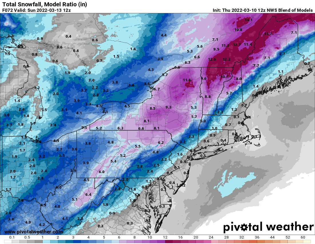
High pressure remains in control into Friday with generally dry weather. We’ll be on the chilly side tonight, but temperatures should rebound nicely on Friday, though we’ll see clouds streaming in and thickening up late in the day. This is in advance of a developing low pressure system that will impact us on Saturday. Earlier in the week, it looked like this system would pass west of us, with strong southerly winds bringing in very mild air and rainfall. Well, the latest indications are that the storm will pass right across southern New England, or possibly even south of it. This means that it won’t be as windy or warm as we were thinking earlier, but we’re not looking at a major snowstorm, it’ll still be too mild. We’ll have rain developing by daybreak Saturday, and it could be heavy at times during the day. It may still be quite breezy along the South Coast and across Cape Cod if the system does move across southern New England. Once it passes by during the afternoon it will continue to intensify, with strong northwest winds behind it ushering much colder air back in by late in the day. This will likely result in the rain changing to snow before it ends in the evening. How quickly it changes over and how quickly it moves out will determine whether the snow will accumulate. Right now, the best odds for any accumulation will be from central Massachusetts into southwestern and central New Hampshire. Farther north and west, this will be quite a storm for ski country, which is good news for them.
Behind the storm, we’ll clear out for Saturday night and Sunday with high pressure building in. It will be breezy and quite chilly, but this won’t last long. Winds will subside Sunday afternoon, and as the high moves off to the east, temperatures will moderate nicely on Monday.
Thursday night: Clear to partly cloudy. Low 24-31.
Friday: Some morning sun, then increasing and thickening clouds. High 46-53.
Friday night: Mostly cloudy, rain develops before daybreak. Low 31-38.
Saturday: Rain, heavy at times, possibly changing to snow late in the day, becoming windy. High 45-52, possibly a little warmer across southeastern Massachusetts and Rhode Island. Temperatures will quickly drop during the afternoon
Saturday night: Windy with rain or snow showers ending in the evening, clearing late at night. Low 16-23.
Sunday: Sunshine and some afternoon clouds. High 30-37.
Sunday night: Clear to partly cloudy. Low 23-30.
Monday: Mostly sunny, some clouds may pop up in the afternoon. High 46-53.
